01/31 Possible Winter Storm
+39
crippo84
jaydoy
CnWestMilford76
SoulSingMG
DAYBLAZER
SkiSeadooJoe
weatherwatchermom
GreyBeard
Grselig
essexcountypete
Joe Snow
nutleyblizzard
mwilli
le88kb
bobjohnsonforthehall
algae888
billg315
hurrysundown23
hyde345
docstox12
dsix85
TheAresian
phil155
Snownyc
CPcantmeasuresnow
heehaw453
adamfitz1969
larryrock72
SENJsnowman
Dunnzoo
rb924119
jmanley32
aiannone
amugs
sroc4
dkodgis
frank 638
Irish
Frank_Wx
43 posters
Page 1 of 30
Page 1 of 30 • 1, 2, 3 ... 15 ... 30 
 01/31 Possible Winter Storm
I don’t have time for an elaborate write up at this time, but I wanted to make space for us to share our thoughts specific to this Sunday’s possible winter storm. The pattern is conducive for a deepening low pressure to form off our coast.


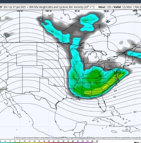
This is a look at the broader pattern (created by user on Twitter). Besides the Pacific, everything is falling into place the way we would want. Now, the Pacific is not completely failing us. The timing of the trough entering the PAC NW is key because it amplifies the western ridge and the trough upstream. The shortwave on the backside of said trough is modeled to be very potent. A second surface low transfers to the coast because of the blocking directly to our north (we have an HP this time just like the December storm). Also, this is a much colder air mass than what we had in December. Temps leading up to this storm are in the teens and single digits for most. So, ingredients are there. Stage is set. Will this be a prime time show or something an episode of three stooges?
Stay tuned!
_________________
_______________________________________________________________________________________________________
CLICK HERE to view NJ Strong Snowstorm Classifications
 Re: 01/31 Possible Winter Storm
_________________
_______________________________________________________________________________________________________
CLICK HERE to view NJ Strong Snowstorm Classifications
 Re: 01/31 Possible Winter Storm
OK, so obviously, there's still a ton of time between now and Sunday. However, what would be the worst case scenario?

Irish- Pro Enthusiast

- Posts : 788
Reputation : 19
Join date : 2019-01-16
Age : 46
Location : Old Bridge, NJ
 Re: 01/31 Possible Winter Storm
Thank you so much Frank for your post bring it on finally this quiet and boring weather pattern has woken up
frank 638- Senior Enthusiast

- Posts : 2861
Reputation : 37
Join date : 2016-01-01
Age : 41
Location : bronx ny
 Re: 01/31 Possible Winter Storm
I’m all in

dkodgis- Senior Enthusiast

- Posts : 2661
Reputation : 98
Join date : 2013-12-29
 Re: 01/31 Possible Winter Storm
That HP parked over top looks beautiful.
_________________
"In weather and in life, there's no winning and losing; there's only winning and learning."
WINTER 2012/2013 TOTALS 43.65"WINTER 2017/2018 TOTALS 62.85" WINTER 2022/2023 TOTALS 4.9"
WINTER 2013/2014 TOTALS 64.85"WINTER 2018/2019 TOTALS 14.25" WINTER 2023/2024 TOTALS 13.1"
WINTER 2014/2015 TOTALS 71.20"WINTER 2019/2020 TOTALS 6.35"
WINTER 2015/2016 TOTALS 35.00"WINTER 2020/2021 TOTALS 37.75"
WINTER 2016/2017 TOTALS 42.25"WINTER 2021/2022 TOTALS 31.65"

sroc4- Admin

- Posts : 8441
Reputation : 302
Join date : 2013-01-07
Location : Wading River, LI
 Re: 01/31 Possible Winter Storm
Scott reminds me of some very classic storms for the region. No in depth talk but wish it were Saturday.sroc4 wrote:That HP parked over top looks beautiful.
EPS looks....AMAZING!!
_________________
Mugs
AKA:King: Snow Weenie
Self Proclaimed
WINTER 2014-15 : 55.12" +.02 for 6 coatings (avg. 35")
WINTER 2015-16 Total - 29.8" (Avg 35")
WINTER 2016-17 : 39.5" so far

amugs- Advanced Forecaster - Mod

- Posts : 15130
Reputation : 213
Join date : 2013-01-07
Age : 54
Location : Hillsdale,NJ
sroc4 likes this post
 Re: 01/31 Possible Winter Storm
amugs wrote:Scott reminds me of some very classic storms for the region. No in depth talk but wish it were Saturday.sroc4 wrote:That HP parked over top looks beautiful.
EPS looks....AMAZING!!
If there is one good signal for this storm it’s that the euro And it’s ensembles are on board. Most storms we had hope for this winter the euro insisted on it missing but the CMC and GFS pulled us in.
_________________
-Alex Iannone-

aiannone- Senior Enthusiast - Mod

- Posts : 4822
Reputation : 92
Join date : 2013-01-07
Location : Saint James, LI (Northwest Suffolk Co.)
 Re: 01/31 Possible Winter Storm
amugs wrote:Scott reminds me of some very classic storms for the region. No in depth talk but wish it were Saturday.sroc4 wrote:That HP parked over top looks beautiful.
EPS looks....AMAZING!!
So, as I posted above, with many things looking amazing, what could go wrong that would give us the worst outcome?

Irish- Pro Enthusiast

- Posts : 788
Reputation : 19
Join date : 2019-01-16
Age : 46
Location : Old Bridge, NJ
 Re: 01/31 Possible Winter Storm
TWC currently has snow accumulations for my area at 10-16 inches this far out.
Thoughts on a Zoom being set up for this storm?
Thoughts on a Zoom being set up for this storm?

Irish- Pro Enthusiast

- Posts : 788
Reputation : 19
Join date : 2019-01-16
Age : 46
Location : Old Bridge, NJ
 Re: 01/31 Possible Winter Storm
Interesting old bridge isnt that far from here, i mean yeah its not close but thats a huge difference as TWC for NYC metro says 3-9 over course of 2.5 days, not going to be much stickage that light, i guess this may be a jersey special not sure how it misses the NYC area by that much being a big storm but in all honestly TWC changes snow totals more than my daughter changes outfits.

jmanley32- Senior Enthusiast

- Posts : 20635
Reputation : 108
Join date : 2013-12-12
Age : 43
Location : Yonkers, NY
 Re: 01/31 Possible Winter Storm
Irish wrote:amugs wrote:Scott reminds me of some very classic storms for the region. No in depth talk but wish it were Saturday.sroc4 wrote:That HP parked over top looks beautiful.
EPS looks....AMAZING!!
So, as I posted above, with many things looking amazing, what could go wrong that would give us the worst outcome?
Totally Mugsy. Irish. I just don’t see a way for this thing to be suppressed so to me the worst case scenario would be to see trends with the closed upper level low at 500 mb as well as the 700mb and 850mb low trend further north and west. When those closed circles are N and W of the area the wind direction changes. Exactly who sees what depends on just how far N and west it makes it. The thing about this set up is that the air mass in place as this arrives is legitimately Arctic in origin. So worst case scenario would likely vary depending on your location. Coastal plain for you and Me our worst case is a NW trend and mixing issues
_________________
"In weather and in life, there's no winning and losing; there's only winning and learning."
WINTER 2012/2013 TOTALS 43.65"WINTER 2017/2018 TOTALS 62.85" WINTER 2022/2023 TOTALS 4.9"
WINTER 2013/2014 TOTALS 64.85"WINTER 2018/2019 TOTALS 14.25" WINTER 2023/2024 TOTALS 13.1"
WINTER 2014/2015 TOTALS 71.20"WINTER 2019/2020 TOTALS 6.35"
WINTER 2015/2016 TOTALS 35.00"WINTER 2020/2021 TOTALS 37.75"
WINTER 2016/2017 TOTALS 42.25"WINTER 2021/2022 TOTALS 31.65"

sroc4- Admin

- Posts : 8441
Reputation : 302
Join date : 2013-01-07
Location : Wading River, LI
Irish likes this post
 Re: 01/31 Possible Winter Storm
And watch it does the switcharoo and the opposite is right this time, though I cannot see the Euro (can someone post maps?) the GFS and CMC are both showing good snows for several runs now. GFS has been very steadfast for quite a few runs now. I guess we will see. Gonna stay cautiously optimistic, I can say if its gonna be a big storm this would be the date for it to happen as I am supposed to travel to CT for family and I am not going to get another chance anytime soon so it will likely be a blitz.aiannone wrote:amugs wrote:Scott reminds me of some very classic storms for the region. No in depth talk but wish it were Saturday.sroc4 wrote:That HP parked over top looks beautiful.
EPS looks....AMAZING!!
If there is one good signal for this storm it’s that the euro And it’s ensembles are on board. Most storms we had hope for this winter the euro insisted on it missing but the CMC and GFS pulled us in.

jmanley32- Senior Enthusiast

- Posts : 20635
Reputation : 108
Join date : 2013-12-12
Age : 43
Location : Yonkers, NY
 Re: 01/31 Possible Winter Storm
jmanley32 wrote:Interesting old bridge isnt that far from here, i mean yeah its not close but thats a huge difference as TWC for NYC metro says 3-9 over course of 2.5 days, not going to be much stickage that light, i guess this may be a jersey special not sure how it misses the NYC area by that much being a big storm but in all honestly TWC changes snow totals more than my daughter changes outfits.
That's for damn sure and I'm certainly not going to come close to believing that these will be the final projections. Things will change over and over before Sunday. I'm just happy to see that they're so confident that the system is coming that they'd put totals like that in there.

Irish- Pro Enthusiast

- Posts : 788
Reputation : 19
Join date : 2019-01-16
Age : 46
Location : Old Bridge, NJ
 Re: 01/31 Possible Winter Storm
sroc4 wrote:Irish wrote:amugs wrote:Scott reminds me of some very classic storms for the region. No in depth talk but wish it were Saturday.sroc4 wrote:That HP parked over top looks beautiful.
EPS looks....AMAZING!!
So, as I posted above, with many things looking amazing, what could go wrong that would give us the worst outcome?
Totally Mugsy. Irish. I just don’t see a way for this thing to be suppressed so to me the worst case scenario would be to see trends with the closed upper level low at 500 mb as well as the 700mb and 850mb low trend further north and west. When those closed circles are N and W of the area the wind direction changes. Exactly who sees what depends on just how far N and west it makes it. The thing about this set up is that the air mass in place as this arrives is legitimately Arctic in origin. So worst case scenario would likely vary depending on your location. Coastal plain for you and Me our worst case is a NW trend and mixing issues
I'll take that as worst case scenario and am really looking forward to seeing the crew here track this baby over the next few days.

Irish- Pro Enthusiast

- Posts : 788
Reputation : 19
Join date : 2019-01-16
Age : 46
Location : Old Bridge, NJ
sroc4 likes this post
 Re: 01/31 Possible Winter Storm
Only the short range models have come out tonight. They don’t go out far enough, but you can tell they’re ready to explode and show the coastal.
_________________
_______________________________________________________________________________________________________
CLICK HERE to view NJ Strong Snowstorm Classifications
 Re: 01/31 Possible Winter Storm
Analysis in progress.....this is a nightmare lol
rb924119- Meteorologist

- Posts : 7033
Reputation : 195
Join date : 2013-02-06
Age : 32
Location : Greentown, Pa
 Re: 01/31 Possible Winter Storm
It literally boils down to a piece of shear vorticity over New England/southeastern Canada - how it behaves, orientation. What could possibly go wrong in forecasting that at five or six days lead?
rb924119- Meteorologist

- Posts : 7033
Reputation : 195
Join date : 2013-02-06
Age : 32
Location : Greentown, Pa
 Re: 01/31 Possible Winter Storm
Here we go Mr. Doom and gloom lol jk, interested to hear your thoughts.rb924119 wrote:It literally boils down to a piece of shear vorticity over New England/southeastern Canada - how it behaves, orientation. What could possibly go wrong in forecasting that at five or six days lead?

jmanley32- Senior Enthusiast

- Posts : 20635
Reputation : 108
Join date : 2013-12-12
Age : 43
Location : Yonkers, NY
 Re: 01/31 Possible Winter Storm
jmanley32 wrote:Here we go Mr. Doom and gloom lol jk, interested to hear your thoughts.rb924119 wrote:It literally boils down to a piece of shear vorticity over New England/southeastern Canada - how it behaves, orientation. What could possibly go wrong in forecasting that at five or six days lead?
Hey, I’m just a messenger - don’t shoot me lmaooo that said, in formulating my thoughts, I’m seeing evidence that I *might be* on the right track, and I’ll be honest, most of us aren’t gonna like what I have to say.
rb924119- Meteorologist

- Posts : 7033
Reputation : 195
Join date : 2013-02-06
Age : 32
Location : Greentown, Pa
 Re: 01/31 Possible Winter Storm
rb924119 wrote:jmanley32 wrote:Here we go Mr. Doom and gloom lol jk, interested to hear your thoughts.rb924119 wrote:It literally boils down to a piece of shear vorticity over New England/southeastern Canada - how it behaves, orientation. What could possibly go wrong in forecasting that at five or six days lead?
Hey, I’m just a messenger - don’t shoot me lmaooo that said, in formulating my thoughts, I’m seeing evidence that I *might be* on the right track, and I’ll be honest, most of us aren’t gonna like what I have to say.
Oh christ, just once I want good news!

Irish- Pro Enthusiast

- Posts : 788
Reputation : 19
Join date : 2019-01-16
Age : 46
Location : Old Bridge, NJ
 Re: 01/31 Possible Winter Storm
GFS and CMC went crazy tonight. The GFS trends tonight were extremely positive. Stronger ridge and better axis, quicker phasing with the northern stream energy, and better positioning with the mid-level lows.
_________________
_______________________________________________________________________________________________________
CLICK HERE to view NJ Strong Snowstorm Classifications
 Re: 01/31 Possible Winter Storm
rb924119 wrote:It literally boils down to a piece of shear vorticity over New England/southeastern Canada - how it behaves, orientation. What could possibly go wrong in forecasting that at five or six days lead?
Seems like first flakes could fly Sunday afternoon. Not as far out as you may think!
_________________
_______________________________________________________________________________________________________
CLICK HERE to view NJ Strong Snowstorm Classifications
 Re: 01/31 Possible Winter Storm
GFS Ensembles are also much more amplified than 18z
_________________
_______________________________________________________________________________________________________
CLICK HERE to view NJ Strong Snowstorm Classifications
 Re: 01/31 Possible Winter Storm
As the forum starts to get excited about a storm 6-7 days out, rb brings us back to Earth. I hope there will be at least some snow for us all to end the month....
https://www.youtube.com/watch?v=0x-fkSYDtUY
https://www.youtube.com/watch?v=0x-fkSYDtUY
_________________
Janet
Snowfall winter of 2023-2024 17.5"
Snowfall winter of 2022-2023 6.0"
Snowfall winter of 2021-2022 17.6" 1" sleet 2/25/22
Snowfall winter of 2020-2021 51.1"
Snowfall winter of 2019-2020 8.5"
Snowfall winter of 2018-2019 25.1"
Snowfall winter of 2017-2018 51.9"
Snowfall winter of 2016-2017 45.6"
Snowfall winter of 2015-2016 29.5"
Snowfall winter of 2014-2015 50.55"
Snowfall winter of 2013-2014 66.5"

Dunnzoo- Senior Enthusiast - Mod

- Posts : 4920
Reputation : 68
Join date : 2013-01-11
Age : 62
Location : Westwood, NJ
Page 1 of 30 • 1, 2, 3 ... 15 ... 30 
Page 1 of 30
Permissions in this forum:
You cannot reply to topics in this forum|
|
|

 Home
Home
