01/31 Possible Winter Storm
+39
crippo84
jaydoy
CnWestMilford76
SoulSingMG
DAYBLAZER
SkiSeadooJoe
weatherwatchermom
GreyBeard
Grselig
essexcountypete
Joe Snow
nutleyblizzard
mwilli
le88kb
bobjohnsonforthehall
algae888
billg315
hurrysundown23
hyde345
docstox12
dsix85
TheAresian
phil155
Snownyc
CPcantmeasuresnow
heehaw453
adamfitz1969
larryrock72
SENJsnowman
Dunnzoo
rb924119
jmanley32
aiannone
amugs
sroc4
dkodgis
frank 638
Irish
Frank_Wx
43 posters
Page 2 of 30
Page 2 of 30 •  1, 2, 3 ... 16 ... 30
 Re: 01/31 Possible Winter Storm
As the forum starts to get excited about a storm 6-7 days out, rb brings us back to Earth. I hope there will be at least some snow for us all to end the month....
https://www.youtube.com/watch?v=0x-fkSYDtUY
https://www.youtube.com/watch?v=0x-fkSYDtUY
Dunnzoo- Senior Enthusiast - Mod

- Posts : 4904
Join date : 2013-01-11
 Re: 01/31 Possible Winter Storm
Frank_Wx wrote:GFS and CMC went crazy tonight. The GFS trends tonight were extremely positive. Stronger ridge and better axis, quicker phasing with the northern stream energy, and better positioning with the mid-level lows.
That's great news, hopefully, keeps up through tomorrow. Do you have images? This storm is really 84-96 hours out, correct?

Irish- Pro Enthusiast

- Posts : 788
Reputation : 19
Join date : 2019-01-16
Age : 45
Location : Old Bridge, NJ
 Re: 01/31 Possible Winter Storm
It is 4 days out, no idea where you guys are getting 5/6/7 days. Like Frank said flakes could Fly sunday afternoon so by Sat its already thursday we should know close to what will happen.

jmanley32- Senior Enthusiast

- Posts : 20535
Reputation : 108
Join date : 2013-12-12
Age : 43
Location : Yonkers, NY
 Re: 01/31 Possible Winter Storm
my gosh the CMC literally snows from around 7pm sunday to 7am wed with the heaviest in between, crazy. Irish go look at tropical tidbits CMC, not posting the map but we both get pummeled on that run. Queens and rest western LI see i guess a stationary band....just go put it like that haha

jmanley32- Senior Enthusiast

- Posts : 20535
Reputation : 108
Join date : 2013-12-12
Age : 43
Location : Yonkers, NY
Irish likes this post
 Re: 01/31 Possible Winter Storm
Irish wrote:Frank_Wx wrote:GFS and CMC went crazy tonight. The GFS trends tonight were extremely positive. Stronger ridge and better axis, quicker phasing with the northern stream energy, and better positioning with the mid-level lows.
That's great news, hopefully, keeps up through tomorrow. Do you have images? This storm is really 84-96 hours out, correct?
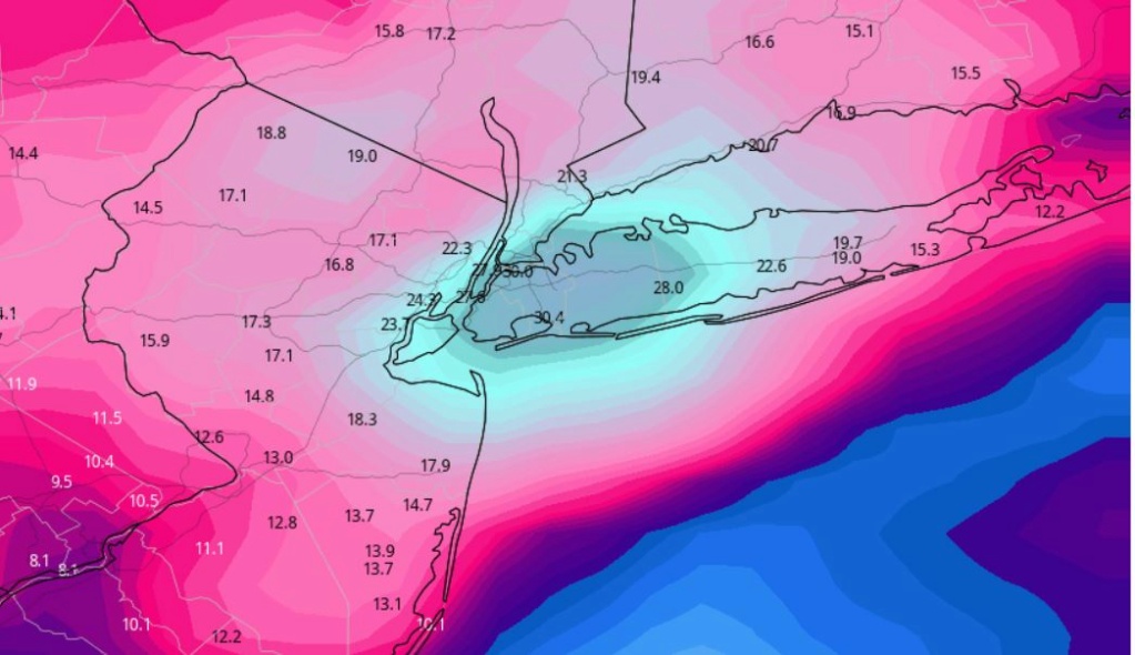
At this point, still a fantasy map perhaps, but is Oh Canada starting to show some consistency?
CMC at 00z tonight
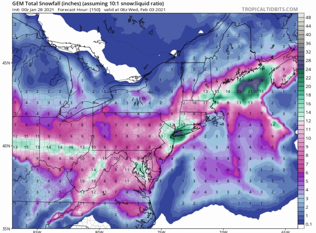 |
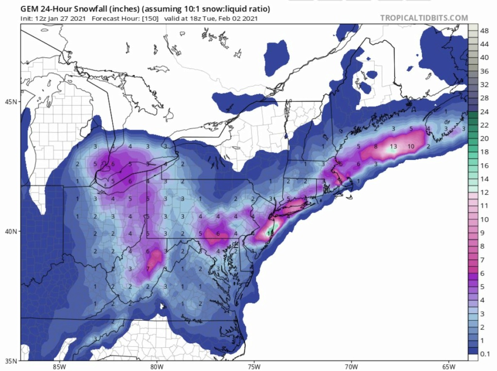
Cautious optimism continues...though my gut is telling me we have a tucked solution coming in. We shall see...
SENJsnowman- Senior Enthusiast

- Posts : 1189
Reputation : 61
Join date : 2017-01-06
Age : 51
Location : Bayville, NJ
 Re: 01/31 Possible Winter Storm
SENJ. I can see snow on the front end Sunday late day/evening. My concern is the rising temp overnight Sunday into Monday especially along the NJ Coast which will turn to a good soaking rain. More inland members north and west should be able to hold colder temps for most of the storm.
larryrock72- Posts : 140
Reputation : 5
Join date : 2017-01-03
Age : 52
Location : Barnegat, NJ
adamfitz1969- Posts : 122
Reputation : 14
Join date : 2018-03-01
Age : 54
Location : Tarrytown
 Re: 01/31 Possible Winter Storm
larryrock72 wrote:SENJ. I can see snow on the front end Sunday late day/evening. My concern is the rising temp overnight Sunday into Monday especially along the NJ Coast which will turn to a good soaking rain. More inland members north and west should be able to hold colder temps for most of the storm.
As I understand it, the rising temps along the coast in this case are going to be solely the result of a tucked storm track. Which history says is the far more likely result unfortunately. But the way these models are consistently keeping us in the game for big totals at this point, we MIGHT have a shot here. I mean, truthfully, every 12z and 00z run is kinda crucial for us at this point. Keep us one wobble away from a heavy snow axis until just before game time and then now track...
But first, I gotta wait patiently for the 12z runs and see what happens. Of course, we're also hitting prime windshield wiper effect territory too, so even changes are ok...until they become a trend. Wow...so much fun today! Time to get a little sleep so I can get my coffee ready for heehaw and the rest of the morning crew update!!
SENJsnowman- Senior Enthusiast

- Posts : 1189
Reputation : 61
Join date : 2017-01-06
Age : 51
Location : Bayville, NJ
 Re: 01/31 Possible Winter Storm
larryrock72 wrote:SENJ. I can see snow on the front end Sunday late day/evening. My concern is the rising temp overnight Sunday into Monday especially along the NJ Coast which will turn to a good soaking rain. More inland members north and west should be able to hold colder temps for most of the storm.
Also, I agree 100%...this is very likely a classic front end thump, change to rain, back end thump scenario for the Shore. I'm not super concerned about the change to rain part right now. I'm concerned for sure, just not super concerned. Honestly, I'll smell the rain all day long and even take some of it on the chin if that clears way for some heavier snow after that. But as far as I can see, our worst case scenario as of now should include at least a decent front or back end thump, which is a 1000x better than any prospect we've had since March 2018.
rb, as a local, what are your prospects for a Coastal Ocean/Lower Monmouth imby result at this point? (based on what you see now...and of course also duly noting the fact that you have had insufficient free time available to conduct, much less write up, a sufficient analysis!
SENJsnowman- Senior Enthusiast

- Posts : 1189
Reputation : 61
Join date : 2017-01-06
Age : 51
Location : Bayville, NJ
larryrock72 likes this post
 Re: 01/31 Possible Winter Storm
the canadian was incredible tonight....with a phase of the northern stream....incredible runs
adamfitz1969- Posts : 122
Reputation : 14
Join date : 2018-03-01
Age : 54
Location : Tarrytown
 Re: 01/31 Possible Winter Storm
Ok, folks. Videos have been cut, and one is in the process of uploading. I decided to do them in two parts; the first covers why I thought the previous system would come further north and lead to a warmer, sloppy mix with little snow for us, but give central New England more. I know there were some questions on that, and I wanted to address them. I also wanted to address a couple of other quick details in there, so I took the opportunity to do so. If you’re curious about the previous event and what I had to say, feel free to listen. If not, no worries. Just keep in mind that I discuss a lot of the same maps and concepts in detail in that first video that I reference again in the second. So if you find you’re confused about things I say in the second and you didn’t watch the first, you might have missed the explanation.
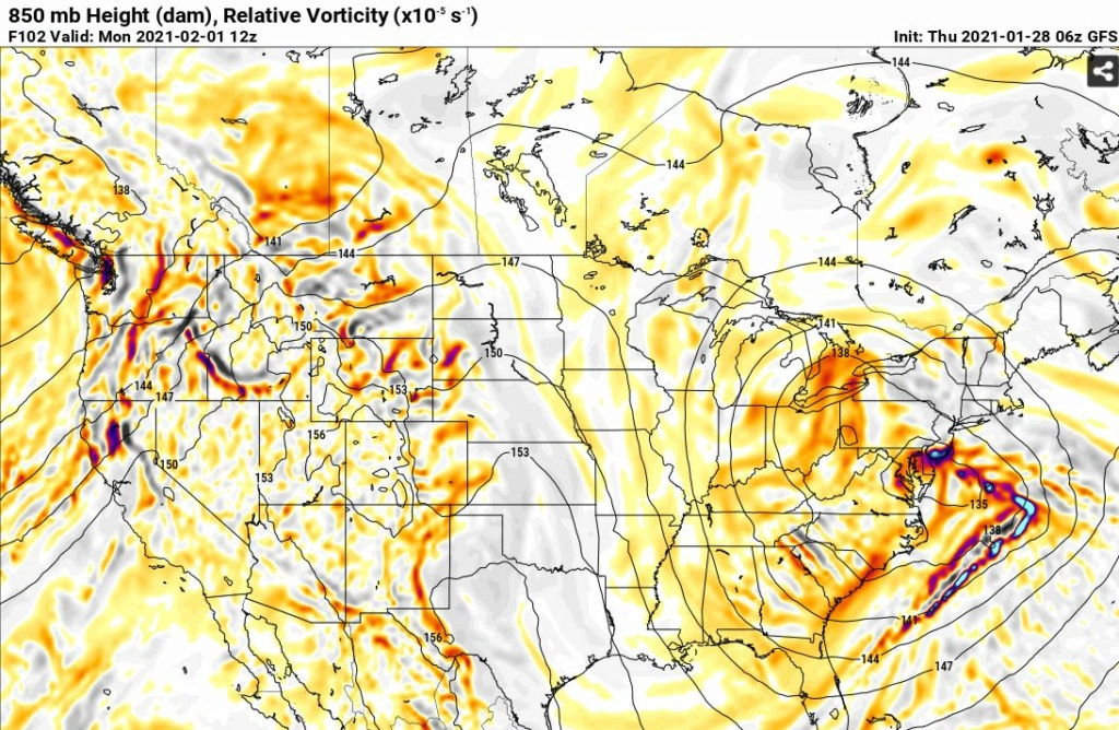
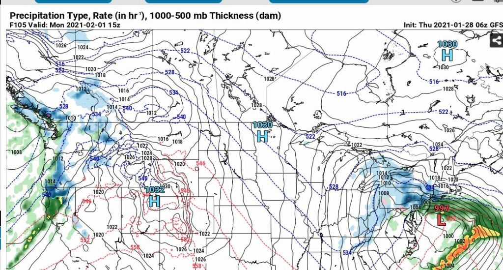
The second video is all about the upcoming storm, but uses a lot of the same ideas described in the first. In short, I think the models are overplaying the role of the blocking/confluence in southeastern Canada/northern New England, and will adjust to have less influence and be more meridionally (north-south, or at least northwest-southeast oriented) in future runs. As a result, that will create more space to allow our system of interest to get further northeast, likely to near the latitude of the NY/PA border, or even slightly northeast of there, before being forced east or slightly south of east beneath the block. Additionally, I think the eastward-displaced ridge that continues to move eastward through the western U.S. will force a redevelopment further east overall, and with a further north track to start, a further north redevelopment as well. This will, therefore, allow warmer air to surge northward and turn most of us, if not all of us over to a mix/rain, and keep the best snow totals over central and northern New England. That said, I think a general 2-5/3-6/4-7 is probable for those north of 195 in NJ and west of the Garden State Parkway before the change.
As usual, I hope you all enjoy the videos, and if you have any questions, please feel free to ask!! Lastly, I want to apologize for the quality - it’s late, and I didn’t want to spend hours trying to make it perfect like I normally try to do. Also, I was definitely rushed because I had a lot to say between the two videos haha anyway, I hope you all enjoy them, and that they make sense! Thanks for watching!!
rb924119- Meteorologist

- Posts : 6928
Reputation : 194
Join date : 2013-02-06
Age : 32
Location : Greentown, Pa
billg315 likes this post
 Re: 01/31 Possible Winter Storm
Quite honestly, I see this being very similar to the December storm in terms of the geographic snowfall distributions and overall evolution.
rb924119- Meteorologist

- Posts : 6928
Reputation : 194
Join date : 2013-02-06
Age : 32
Location : Greentown, Pa
 Re: 01/31 Possible Winter Storm
Also, each video is about 20 minutes. I did a better job this time of keeping them a little shorter than the last one lol I’ll post the links in the morning......or, later in the morning when I get up lol
rb924119- Meteorologist

- Posts : 6928
Reputation : 194
Join date : 2013-02-06
Age : 32
Location : Greentown, Pa
larryrock72 likes this post
 Re: 01/31 Possible Winter Storm
_________________
_______________________________________________________________________________________________________
CLICK HERE to view NJ Strong Snowstorm Classifications
 Re: 01/31 Possible Winter Storm
Frank_Wx wrote:GFS and CMC went crazy tonight. The GFS trends tonight were extremely positive. Stronger ridge and better axis, quicker phasing with the northern stream energy, and better positioning with the mid-level lows.
Absolutely massive hits. Thermal profiles will be a concern along and SE of the 95 if this amps up. However, staying on the good side of the thermals can render the goods in a big way.
heehaw453- Advanced Forecaster

- Posts : 3906
Reputation : 86
Join date : 2014-01-20
Location : Bedminster Township, PA Elevation 600' ASL
 Re: 01/31 Possible Winter Storm
I’m confused about what you say about the first storm and the heaviest snows hitting central New England? The heaviest snows from the Dec 16-17 storm were in Central New York State from Binghamton to Albany. That whole area received from 24-44 inches of snow.

CPcantmeasuresnow- Wx Statistician Guru

- Posts : 7274
Reputation : 230
Join date : 2013-01-07
Age : 103
Location : Eastern Orange County, NY
heehaw453- Advanced Forecaster

- Posts : 3906
Reputation : 86
Join date : 2014-01-20
Location : Bedminster Township, PA Elevation 600' ASL
 Re: 01/31 Possible Winter Storm
CPcantmeasuresnow wrote:I’m confused about what you say about the first storm and the heaviest snows hitting central New England? The heaviest snows from the Dec 16-17 storm were in Central New York State from Binghamton to Albany. That whole area received from 24-44 inches of snow.
He’s referring to the storm of two days ago
_________________
_______________________________________________________________________________________________________
CLICK HERE to view NJ Strong Snowstorm Classifications
CPcantmeasuresnow likes this post
 Re: 01/31 Possible Winter Storm
Good morning and hello to everyone. It’s been about 5 years since we got a classic these are the perfect setups but they come with heart breaks a lot.this can easily be a storm for the books for both reasons it comes together just right and most be over happy or a phase more east and just some lighter snows this is what the board was made for the tracking gotta love it and yes I been following since accuchat just never signed up
Snownyc- Posts : 23
Reputation : 0
Join date : 2021-01-27
 Re: 01/31 Possible Winter Storm
All weather sites has nyc over a foot in their 7 day forecast hope it ain’t a ginx and this storm is only about 80 hrs out of reach
Snownyc- Posts : 23
Reputation : 0
Join date : 2021-01-27
 Re: 01/31 Possible Winter Storm
rb924119 wrote:Also, each video is about 20 minutes. I did a better job this time of keeping them a little shorter than the last one lol I’ll post the links in the morning......or, later in the morning when I get up lol
Where would I find your videos?
phil155- Pro Enthusiast

- Posts : 483
Reputation : 4
Join date : 2019-12-16
 Re: 01/31 Possible Winter Storm
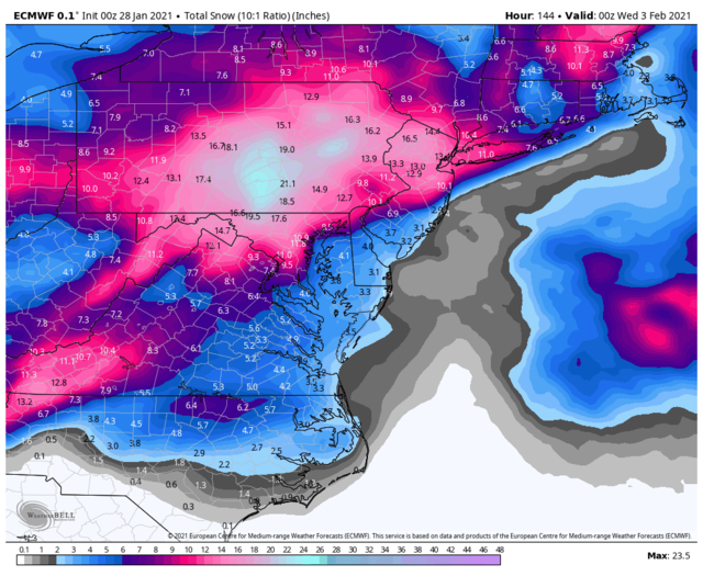
I don’t like what the euro is doing at all
_________________
"In weather and in life, there's no winning and losing; there's only winning and learning."
WINTER 2012/2013 TOTALS 43.65"WINTER 2017/2018 TOTALS 62.85" WINTER 2022/2023 TOTALS 4.9"
WINTER 2013/2014 TOTALS 64.85"WINTER 2018/2019 TOTALS 14.25" WINTER 2023/2024 TOTALS 13.1"
WINTER 2014/2015 TOTALS 71.20"WINTER 2019/2020 TOTALS 6.35"
WINTER 2015/2016 TOTALS 35.00"WINTER 2020/2021 TOTALS 37.75"
WINTER 2016/2017 TOTALS 42.25"WINTER 2021/2022 TOTALS 31.65"

sroc4- Admin

- Posts : 8354
Reputation : 302
Join date : 2013-01-07
Location : Wading River, LI
 Re: 01/31 Possible Winter Storm
That's both ominous and vague. Would you care to elaborate?
TheAresian- Senior Enthusiast

- Posts : 145
Reputation : 10
Join date : 2019-11-13
Location : Painted Post, NY
heehaw453- Advanced Forecaster

- Posts : 3906
Reputation : 86
Join date : 2014-01-20
Location : Bedminster Township, PA Elevation 600' ASL
heehaw453- Advanced Forecaster

- Posts : 3906
Reputation : 86
Join date : 2014-01-20
Location : Bedminster Township, PA Elevation 600' ASL
 Re: 01/31 Possible Winter Storm
TheAresian wrote:That's both ominous and vague. Would you care to elaborate?
500mb low tracks from the west looking good but is starting to show it halt and begin tracking west of us. Tucks the sLP track closer to the coast and Brings in the warm air and changes over coastal plain into the lower Hv. I had mentioned earlier about how these systems end up undermodeled in the md range and as we start to get in right the true strength of the system is show. With the blocking relaxing a little is there enough resistance in the atmosphere to keep this oversimplified system from continuing to trend tighter into the coast?
From a big picture stand point We are currently in a moderately amplified MJo phase that favors a warm push in the east combined with the La Niña influences which looking at the SOI indexes indicates similar. So again the the northern resistance relaxing does it relax too much so that the other atmospheric factors take over. Let me be clear I’m not talking about an all out cutter here and warm surge with rain to all but the coastal plain and even into the LHV need to worry about how much change over is seen on Monday.
Add in the fact that ray(rb) has spoken as well
_________________
"In weather and in life, there's no winning and losing; there's only winning and learning."
WINTER 2012/2013 TOTALS 43.65"WINTER 2017/2018 TOTALS 62.85" WINTER 2022/2023 TOTALS 4.9"
WINTER 2013/2014 TOTALS 64.85"WINTER 2018/2019 TOTALS 14.25" WINTER 2023/2024 TOTALS 13.1"
WINTER 2014/2015 TOTALS 71.20"WINTER 2019/2020 TOTALS 6.35"
WINTER 2015/2016 TOTALS 35.00"WINTER 2020/2021 TOTALS 37.75"
WINTER 2016/2017 TOTALS 42.25"WINTER 2021/2022 TOTALS 31.65"

sroc4- Admin

- Posts : 8354
Reputation : 302
Join date : 2013-01-07
Location : Wading River, LI
Page 2 of 30 •  1, 2, 3 ... 16 ... 30
Page 2 of 30
Permissions in this forum:
You cannot reply to topics in this forum|
|
|

 Home
Home