February 1st-2nd Godzilla, Part III: 1st Call Snow Map
Page 1 of 24 • 1, 2, 3 ... 12 ... 24 
 February 1st-2nd Godzilla, Part III: 1st Call Snow Map
1. Primary low near Ohio gives way to a secondary low near Hatteras. The initial WAA, or overrunning snow, may drop 4"+ over parts of the area. Especially the more SW you are.
2. 500mb, 700mb, and 850mb lows will pass to our south then head northeast off the coast
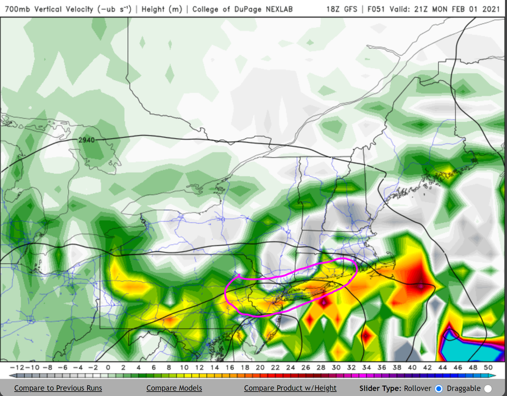
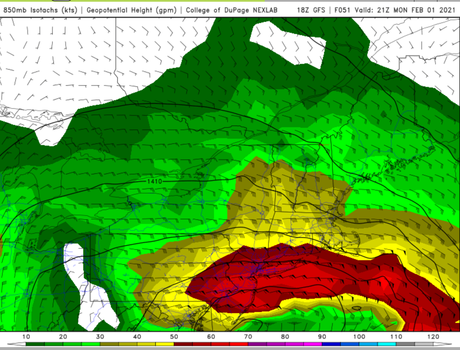
3. As these mid-level lows approach our area, enhanced H5 PvA / 700mb vertical velocity along an extremely powerful low level jet will enable 2-3"/hour snowfall rates over parts of PA, NJ, NYC and LI
4. The high latitude blocking will allow the surface low to slow down once it reaches our latitude, then as the trough amplifies from northern stream phasing, this low is likely to stall/occlude off NJ coast while pounding the area with moderate to heavy snow
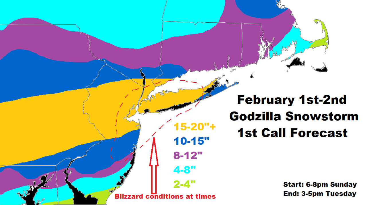
5. There will be high winds at certain times over immediate coastal sections. This includes NYC and LI. Blizzard conditions are probable if not highly likely. We'll see if Upton issues Blizzard Warnings
6. My snow map is angled more W-E than SW-NE because we're getting precip from overrunning, the banding from the secondary as it comes up the coast, and the CCB that develops once the trough closes off and the SLP is captured. Ratios will be 10:1, but I can see north-central NJ, NW NJ, SE NY and EPA get into higher ratios given there very cold temps.
GFS 700mb VV's - other models also place the best VV's over this circled area
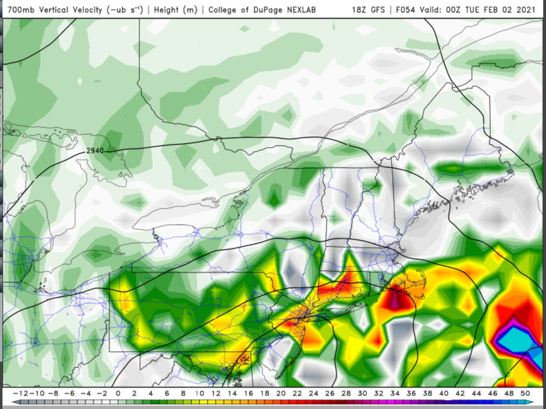
Then you can see it angles SW to NE
GFS 850mb LLJ - absolute annihilation
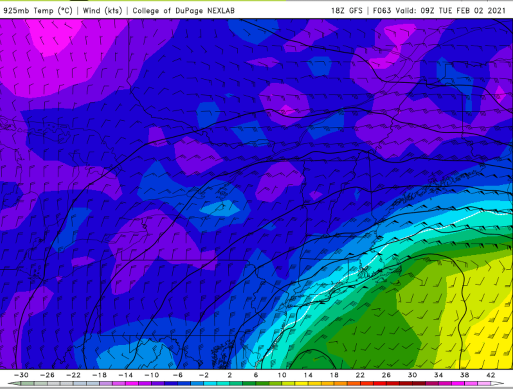
GFS 925mb temps - this is the warmest frame but notice the time stamp. It is 4am Tuesday, when damage has already been done. Because the SLP is tucked into the coast, some drier air will work its way in over coastal sections and LI. There may be a period of rain/sleet but not much at all.
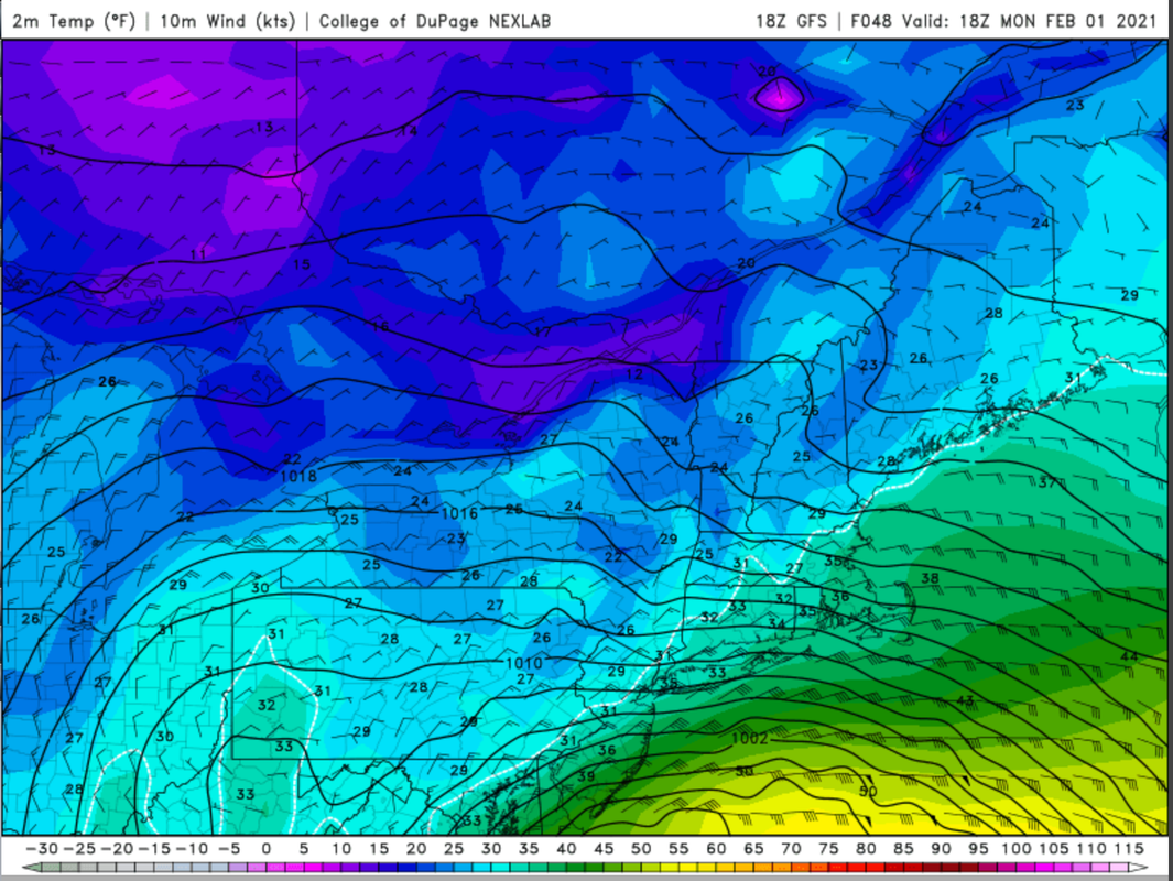
GFS surface temps - marginal if not warm for the shore, NYC and LI. Time stamp is early Monday afternoon. That also happens to be the heart of this storm, when insane precip rates are likely to fall. Therefore, I am not putting a whole lot of stock into the surface temps as I think snow will have no issue accumulating. I think the GFS is over-doing them quite frankly. Wet bulb will keep these areas below freezing.
1st call snow map - I don't think this storm is playing games. I think it will be the real deal for the reasons called out above. Virtually every model is painting Godzilla snow amounts for the NYC metro area. Regardless of the models, I really tried to base this map off where the best dynamics will be. Small changes with the path of the SLP would mean consequences to this map, because you are risking a new placement with the LLJ and 700mb VV's. Some ensemble members try to bring this low even MORE west, which would bring warmer air into the shore, NYC, and LI. These places are right on the fringe as is, which is also why they will see the best snowfall rates from this storm. Since this is a highly volatile system this is also a highly volatile first call. I would be shocked if I did not have to issue a second map. Most likely I will, but not until tomorrow afternoon.
_________________
_______________________________________________________________________________________________________
CLICK HERE to view NJ Strong Snowstorm Classifications
SkiSeadooJoe, rb924119, Grselig, dolphins222, brownie, dkodgis, weatherwatchermom and like this post
 Re: February 1st-2nd Godzilla, Part III: 1st Call Snow Map

weatherwatchermom- Senior Enthusiast

- Posts : 3793
Reputation : 78
Join date : 2014-11-25
Location : Hazlet Township, NJ
 Re: February 1st-2nd Godzilla, Part III: 1st Call Snow Map
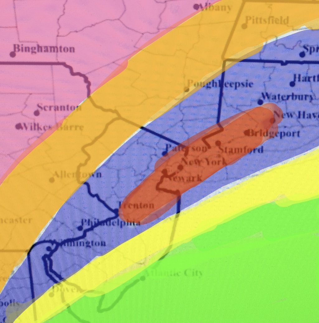
billg315 wrote:Green: Mostly Rain. Snow at start and end but so much more rain as to render any accumulation marginal. But watch winds and coastal flooding.
Yellow: 5-10”. Snow will have some sleet and rain mix in at times in the middle of the storm, especially close to the shore, which will keep totals down a tad. If you get less mixing you’ll be closer to 10”; more and you’ll be near 5”.
Blue/Purple: 10-15”. Heavy snow throughout. Maybe a lull during transfer to coastal early Monday, but will pick up again as coastal takes over.
Red (in middle of Blue): 15-20” in jackpot zone. CCB band crushes it.
Orange: 5-10” of snow. Good steady snow but just a tad away from the heaviest bands.
Pink: 3-5” of snow. I just think this is going to be where the cutoff is for the really heavy snow from the coastal. This area may benefit more from the WWA out front which could boost this total a bit.
_________________
_______________________________________________________________________________________________________
CLICK HERE to view NJ Strong Snowstorm Classifications
 Re: February 1st-2nd Godzilla, Part III: 1st Call Snow Map
Your map and analysis, awesome as always.

billg315- Advanced Forecaster - Mod

- Posts : 4483
Reputation : 185
Join date : 2015-01-24
Age : 50
Location : Flemington, NJ
 Re: February 1st-2nd Godzilla, Part III: 1st Call Snow Map

jmanley32- Senior Enthusiast

- Posts : 20535
Reputation : 108
Join date : 2013-12-12
Age : 43
Location : Yonkers, NY
 Re: February 1st-2nd Godzilla, Part III: 1st Call Snow Map
frank 638- Senior Enthusiast

- Posts : 2843
Reputation : 37
Join date : 2016-01-01
Age : 40
Location : bronx ny
 Re: February 1st-2nd Godzilla, Part III: 1st Call Snow Map
As stated in my write-up, the banding with this storm is horizontal and as such my map reflects that

_________________
_______________________________________________________________________________________________________
CLICK HERE to view NJ Strong Snowstorm Classifications
 Re: February 1st-2nd Godzilla, Part III: 1st Call Snow Map

_________________
_______________________________________________________________________________________________________
CLICK HERE to view NJ Strong Snowstorm Classifications
Zhukov1945 likes this post
 Re: February 1st-2nd Godzilla, Part III: 1st Call Snow Map
frank 638- Senior Enthusiast

- Posts : 2843
Reputation : 37
Join date : 2016-01-01
Age : 40
Location : bronx ny
CPcantmeasuresnow likes this post
 Re: February 1st-2nd Godzilla, Part III: 1st Call Snow Map

_________________
_______________________________________________________________________________________________________
CLICK HERE to view NJ Strong Snowstorm Classifications
CPcantmeasuresnow likes this post
 Re: February 1st-2nd Godzilla, Part III: 1st Call Snow Map

_________________
_______________________________________________________________________________________________________
CLICK HERE to view NJ Strong Snowstorm Classifications
 Re: February 1st-2nd Godzilla, Part III: 1st Call Snow Map
Frank_Wx wrote:Oh jesus
Overlay that with your snow map and you have a legit blizzard.

billg315- Advanced Forecaster - Mod

- Posts : 4483
Reputation : 185
Join date : 2015-01-24
Age : 50
Location : Flemington, NJ
 Re: February 1st-2nd Godzilla, Part III: 1st Call Snow Map
Watch the pivot points to the north of 700/850hPa mid level low redevelopment on Monday for clues as to where axis of heavy snowfall could begin. Forecast models suggest a 70+kt LLJ will develop in this region as the coastal low takes over. pic.twitter.com/GUQqrph9D2
— John Homenuk (@jhomenuk) January 30, 2021
_________________
_______________________________________________________________________________________________________
CLICK HERE to view NJ Strong Snowstorm Classifications
 Re: February 1st-2nd Godzilla, Part III: 1st Call Snow Map
Grselig- Senior Enthusiast

- Posts : 1408
Reputation : 140
Join date : 2013-03-04
Age : 54
Location : Wayne NJ
 Re: February 1st-2nd Godzilla, Part III: 1st Call Snow Map
The new 18z #NAM advertising some insane snowfall rates as the coastal storm develops offshore Monday PM.
— Allan Nosoff (@AWxNYC) January 30, 2021
A 1-2"+/hr snow band will likely develop; exact placement still TBD. Stay tuned!pic.twitter.com/zbNs3e3HVW
_________________
_______________________________________________________________________________________________________
CLICK HERE to view NJ Strong Snowstorm Classifications
 Re: February 1st-2nd Godzilla, Part III: 1st Call Snow Map
Man those 850s Late Monday night into Tuesday over Long Island are not good at all....Frank_Wx wrote:EURO closely resembles my first forecast, but believes I should expand the yellow more S-SE. We'll see! Temps scare me a bit there. But holy capocollo! What a run

mmanisca- Pro Enthusiast

- Posts : 299
Reputation : 3
Join date : 2013-01-23
Age : 65
Location : Deer Park, Long Island
 Re: February 1st-2nd Godzilla, Part III: 1st Call Snow Map
mwilli- Posts : 132
Reputation : 3
Join date : 2019-02-11
 Re: February 1st-2nd Godzilla, Part III: 1st Call Snow Map
heehaw453- Advanced Forecaster

- Posts : 3906
Reputation : 86
Join date : 2014-01-20
Location : Bedminster Township, PA Elevation 600' ASL
 Re: February 1st-2nd Godzilla, Part III: 1st Call Snow Map
Can it get any bettter than this for me?!! Thats a blizzard even well inland if that map verified, which with these convective dynamics could at times and the criteria is 35mph, which should be no issue achiving. where does it stop! only thundersnow will complete this as the best storm ever in my recent memory, PLEASE don't let us down. 55-65mph gusts this has not been discussed yet by major outlets, but the Euro usually overdoes winds but this close in yup, def blizzard conditions if not warnings. As soon as those go up let the panic ensue, I had a mad dash to find new winter wear and everywhere was sold out!! Still need new gloves gonna have keep looking tomorrow, my wife found one lowly snow suit at target and she said the lines were to the back of the isles.billg315 wrote:Frank_Wx wrote:Oh jesus
Overlay that with your snow map and you have a legit blizzard.
Last edited by jmanley32 on Sat Jan 30, 2021 7:35 pm; edited 1 time in total

jmanley32- Senior Enthusiast

- Posts : 20535
Reputation : 108
Join date : 2013-12-12
Age : 43
Location : Yonkers, NY
SENJsnowman likes this post
 Re: February 1st-2nd Godzilla, Part III: 1st Call Snow Map
jmanley32 wrote:Can it get any bettter than this for me?!! where does it stop! only thundersnow will complete this as the best storm ever. 61mph jeeze, but the Euro usually overdoes winds but this close in yup, def blizzard conditions if not warnings. As soon as those go up let the panic ensue, i had a mad dash to find new winter wear and everywhere was sold out!! Still need new gloves gonna have keep looking tomorrow, my wife found one lowly snow suit at target and she said the lines were to the back of the isles.billg315 wrote:Frank_Wx wrote:Oh jesus
Overlay that with your snow map and you have a legit blizzard.
Oh boy. So the panic has begun. We tried to get snow boots for our 1 year old dog. Ordered online for pickup. I wonder if they sold out. Yes, he likes to eat the snow.

Grselig- Senior Enthusiast

- Posts : 1408
Reputation : 140
Join date : 2013-03-04
Age : 54
Location : Wayne NJ
 Re: February 1st-2nd Godzilla, Part III: 1st Call Snow Map
Hpow long is the duration of the winds, thats just one frame? That will determine any warnings I think. Oh thats accumulated I see, but still over what period of time?Frank_Wx wrote:Oh jesus

jmanley32- Senior Enthusiast

- Posts : 20535
Reputation : 108
Join date : 2013-12-12
Age : 43
Location : Yonkers, NY
 Re: February 1st-2nd Godzilla, Part III: 1st Call Snow Map
Yeah and we did not plan to well and have get groceries tomorrow lol, will go as soon as they open and will likely be okay then.Grselig wrote:jmanley32 wrote:Can it get any bettter than this for me?!! where does it stop! only thundersnow will complete this as the best storm ever. 61mph jeeze, but the Euro usually overdoes winds but this close in yup, def blizzard conditions if not warnings. As soon as those go up let the panic ensue, i had a mad dash to find new winter wear and everywhere was sold out!! Still need new gloves gonna have keep looking tomorrow, my wife found one lowly snow suit at target and she said the lines were to the back of the isles.billg315 wrote:Frank_Wx wrote:Oh jesus
Overlay that with your snow map and you have a legit blizzard.
Oh boy. So the panic has begun. We tried to get snow boots for our 1 year old dog. Ordered online for pickup. I wonder if they sold out. Yes, he likes to eat the snow.

jmanley32- Senior Enthusiast

- Posts : 20535
Reputation : 108
Join date : 2013-12-12
Age : 43
Location : Yonkers, NY
Grselig likes this post
 Re: February 1st-2nd Godzilla, Part III: 1st Call Snow Map
Guest- Guest
 Re: February 1st-2nd Godzilla, Part III: 1st Call Snow Map
https://www.weather.gov/media/okx/01302021pm_socialmedia.pdf

jmanley32- Senior Enthusiast

- Posts : 20535
Reputation : 108
Join date : 2013-12-12
Age : 43
Location : Yonkers, NY
 Re: February 1st-2nd Godzilla, Part III: 1st Call Snow Map
Rooster89 wrote:What does that guys tweet mean?
@Rooster89 do you mean the Zilla reference? Between 12-23 inches Frank changes the banner to Godzilla mode. I think above 23 its a Roidzilla. Just fun stuff

Grselig- Senior Enthusiast

- Posts : 1408
Reputation : 140
Join date : 2013-03-04
Age : 54
Location : Wayne NJ
Page 1 of 24 • 1, 2, 3 ... 12 ... 24 

 Home
Home