
 Search
Super Bowl Snowstorm, Part II: First Call
Page 1 of 14 • 1, 2, 3 ... 7 ... 14 ![]()

Super Bowl Snowstorm, Part II: First Call
![]() by Frank_Wx Fri Feb 05, 2021 7:43 pm
by Frank_Wx Fri Feb 05, 2021 7:43 pm
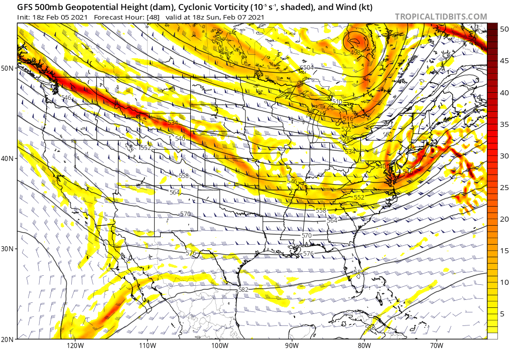
GFS 500mb
NAM 500mb
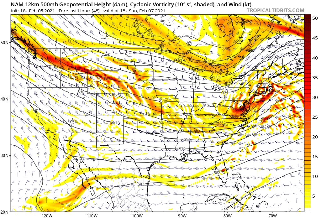
The NAM is showing an area-wide 8-12" snowstorm. A true Mothrazilla. The reason for that is how much it amplifies heights along the coast, allowing the upper air vorticity and SLP to track along the NJ shore. On the other hand, notice how the GFS is a bit more east with the trough. However, it has been trending west for at least 4 consecutive runs. If these trends continue, it will not be far off from the NAM. I would say the EURO is closer to the GFS than it is the NAM.
My snow map reflects a blend of the NAM and GFS/EURO, but my gut tells me we will not see this come much further NW in tonight or tomorrow's runs. The 250mb jet is too far south and east, and there is only partial phasing with the northern jet which is not enough to tug the low so much into the coast. This to me resembles a true southern stream low. It is likely to start as rain for the shore and SNJ before changing to snow. As the precip rates get heavier, the column will cool and gradually transition to snow. The snow will definitely be heavy at times. It is going to blanket the area quickly. It looks like an 8-10 hour storm.
Obviously, I could be wrong with the track of the storm and it very well could keep trending more and more NW. If so, the jackpot area will expand further inland/north, but the risk of LESS snow would also grow for those along the immediate coast as warmer air invades. Let's see what tonight's models do.
_________________
_______________________________________________________________________________________________________
CLICK HERE to view NJ Strong Snowstorm Classifications

Frank_Wx- Godzilla Seeker

- Posts : 21305
Reputation : 328
Join date : 2013-01-05
Age : 32
Location : Jersey City, NJ -

SkiSeadooJoe, weatherwatchermom, billg315 and Bwtr like this post
Re: Super Bowl Snowstorm, Part II: First Call
![]() by Snow88 Fri Feb 05, 2021 8:06 pm
by Snow88 Fri Feb 05, 2021 8:06 pm
I wouldnt be shocked to see this bump northwest again tonight

Snow88- Senior Enthusiast

- Posts : 2193
Reputation : 4
Join date : 2013-01-09
Age : 35
Location : Brooklyn, NY
Re: Super Bowl Snowstorm, Part II: First Call
![]() by billg315 Fri Feb 05, 2021 8:11 pm
by billg315 Fri Feb 05, 2021 8:11 pm

billg315- Advanced Forecaster - Mod

- Posts : 4483
Reputation : 185
Join date : 2015-01-24
Age : 50
Location : Flemington, NJ
amugs likes this post
Re: Super Bowl Snowstorm, Part II: First Call
![]() by jmanley32 Fri Feb 05, 2021 8:32 pm
by jmanley32 Fri Feb 05, 2021 8:32 pm

jmanley32- Senior Enthusiast
- Posts : 20535
Reputation : 108
Join date : 2013-12-12
Age : 43
Location : Yonkers, NY
SENJsnowman likes this post
frank 638- Senior Enthusiast
- Posts : 2843
Reputation : 37
Join date : 2016-01-01
Age : 40
Location : bronx ny
Re: Super Bowl Snowstorm, Part II: First Call
![]() by Frank_Wx Fri Feb 05, 2021 9:33 pm
by Frank_Wx Fri Feb 05, 2021 9:33 pm

_________________
_______________________________________________________________________________________________________
CLICK HERE to view NJ Strong Snowstorm Classifications
Frank_Wx- Godzilla Seeker
- Posts : 21305
Reputation : 328
Join date : 2013-01-05
Age : 32
Location : Jersey City, NJ -
Re: Super Bowl Snowstorm, Part II: First Call
![]() by Frank_Wx Fri Feb 05, 2021 9:57 pm
by Frank_Wx Fri Feb 05, 2021 9:57 pm


_________________
_______________________________________________________________________________________________________
CLICK HERE to view NJ Strong Snowstorm Classifications
Frank_Wx- Godzilla Seeker
- Posts : 21305
Reputation : 328
Join date : 2013-01-05
Age : 32
Location : Jersey City, NJ -
Re: Super Bowl Snowstorm, Part II: First Call
![]() by Frank_Wx Fri Feb 05, 2021 9:58 pm
by Frank_Wx Fri Feb 05, 2021 9:58 pm
Frank_Wx wrote:Negative trends with the upper level jet on last three runs of the NAM. Hence my concern for this to come too far NW like 12z/18z runs showed. Wouldn’t shock me to see this tick even more SE tomorrow.
_________________
_______________________________________________________________________________________________________
CLICK HERE to view NJ Strong Snowstorm Classifications
Frank_Wx- Godzilla Seeker
- Posts : 21305
Reputation : 328
Join date : 2013-01-05
Age : 32
Location : Jersey City, NJ -
Re: Super Bowl Snowstorm, Part II: First Call
![]() by jmanley32 Fri Feb 05, 2021 10:00 pm
by jmanley32 Fri Feb 05, 2021 10:00 pm
Im confused what you just wrote your concerned it will get too far NW but you expect it to go further SE tomorrow? So does that mean you expect totals to be even lower for NYC area or do you still think ur map is good?Frank_Wx wrote:Negative trends with the upper level jet on last three runs of the NAM. Hence my concern for this to come too far NW like 12z/18z runs showed. Wouldn’t shock me to see this tick even more SE tomorrow.
jmanley32- Senior Enthusiast
- Posts : 20535
Reputation : 108
Join date : 2013-12-12
Age : 43
Location : Yonkers, NY
Re: Super Bowl Snowstorm, Part II: First Call
![]() by jmanley32 Fri Feb 05, 2021 10:01 pm
by jmanley32 Fri Feb 05, 2021 10:01 pm
jmanley32- Senior Enthusiast
- Posts : 20535
Reputation : 108
Join date : 2013-12-12
Age : 43
Location : Yonkers, NY
Re: Super Bowl Snowstorm, Part II: First Call
![]() by aiannone Fri Feb 05, 2021 10:03 pm
by aiannone Fri Feb 05, 2021 10:03 pm

_________________
-Alex Iannone-

aiannone- Senior Enthusiast - Mod
- Posts : 4815
Reputation : 92
Join date : 2013-01-07
Location : Saint James, LI (Northwest Suffolk Co.)
Re: Super Bowl Snowstorm, Part II: First Call
![]() by Frank_Wx Fri Feb 05, 2021 10:08 pm
by Frank_Wx Fri Feb 05, 2021 10:08 pm
jmanley32 wrote:Im confused what you just wrote your concerned it will get too far NW but you expect it to go further SE tomorrow? So does that mean you expect totals to be even lower for NYC area or do you still think ur map is good?Frank_Wx wrote:Negative trends with the upper level jet on last three runs of the NAM. Hence my concern for this to come too far NW like 12z/18z runs showed. Wouldn’t shock me to see this tick even more SE tomorrow.
Might get lowered for coastal NJ and parts of LI
_________________
_______________________________________________________________________________________________________
CLICK HERE to view NJ Strong Snowstorm Classifications
Frank_Wx- Godzilla Seeker
- Posts : 21305
Reputation : 328
Join date : 2013-01-05
Age : 32
Location : Jersey City, NJ -
Re: Super Bowl Snowstorm, Part II: First Call
![]() by jmanley32 Fri Feb 05, 2021 10:11 pm
by jmanley32 Fri Feb 05, 2021 10:11 pm
yeah 3km was a nuts run, dunno how much i buy it but I hope!!aiannone wrote:Wow
jmanley32- Senior Enthusiast
- Posts : 20535
Reputation : 108
Join date : 2013-12-12
Age : 43
Location : Yonkers, NY
Re: Super Bowl Snowstorm, Part II: First Call
![]() by Frank_Wx Fri Feb 05, 2021 10:15 pm
by Frank_Wx Fri Feb 05, 2021 10:15 pm

_________________
_______________________________________________________________________________________________________
CLICK HERE to view NJ Strong Snowstorm Classifications
Frank_Wx- Godzilla Seeker
- Posts : 21305
Reputation : 328
Join date : 2013-01-05
Age : 32
Location : Jersey City, NJ -
Re: Super Bowl Snowstorm, Part II: First Call
![]() by aiannone Fri Feb 05, 2021 10:18 pm
by aiannone Fri Feb 05, 2021 10:18 pm
Frank_Wx wrote:RGEM
Frank I think you hit the Vino a bit early. That’s Tuesday’s 12z run
_________________
-Alex Iannone-
aiannone- Senior Enthusiast - Mod
- Posts : 4815
Reputation : 92
Join date : 2013-01-07
Location : Saint James, LI (Northwest Suffolk Co.)
CPcantmeasuresnow and crippo84 like this post
Re: Super Bowl Snowstorm, Part II: First Call
![]() by Frank_Wx Fri Feb 05, 2021 10:22 pm
by Frank_Wx Fri Feb 05, 2021 10:22 pm
aiannone wrote:Frank_Wx wrote:RGEM
Frank I think you hit the Vino a bit early. That’s Tuesday’s 12z run
Oh madonne

_________________
_______________________________________________________________________________________________________
CLICK HERE to view NJ Strong Snowstorm Classifications
Frank_Wx- Godzilla Seeker
- Posts : 21305
Reputation : 328
Join date : 2013-01-05
Age : 32
Location : Jersey City, NJ -
Re: Super Bowl Snowstorm, Part II: First Call
![]() by aiannone Fri Feb 05, 2021 10:25 pm
by aiannone Fri Feb 05, 2021 10:25 pm
Frank_Wx wrote:aiannone wrote:Frank_Wx wrote:RGEM
Frank I think you hit the Vino a bit early. That’s Tuesday’s 12z run
Oh madonne
RGEM has been wavering for days. Hasn’t had one consistent run to run yet
_________________
-Alex Iannone-
aiannone- Senior Enthusiast - Mod
- Posts : 4815
Reputation : 92
Join date : 2013-01-07
Location : Saint James, LI (Northwest Suffolk Co.)
Re: Super Bowl Snowstorm, Part II: First Call
![]() by Frank_Wx Fri Feb 05, 2021 10:28 pm
by Frank_Wx Fri Feb 05, 2021 10:28 pm
I would say SREFS are second worst. Maybe it’s tied
_________________
_______________________________________________________________________________________________________
CLICK HERE to view NJ Strong Snowstorm Classifications
Frank_Wx- Godzilla Seeker
- Posts : 21305
Reputation : 328
Join date : 2013-01-05
Age : 32
Location : Jersey City, NJ -
Re: Super Bowl Snowstorm, Part II: First Call
![]() by aiannone Fri Feb 05, 2021 10:44 pm
by aiannone Fri Feb 05, 2021 10:44 pm
Frank_Wx wrote:RGEM is one of the worst models ever
I would say SREFS are second worst. Maybe it’s tied
Honestly, King Nam so far this winter. And to give credit where it’s deserved, NAM was the first to bring this storm back to life
_________________
-Alex Iannone-
aiannone- Senior Enthusiast - Mod
- Posts : 4815
Reputation : 92
Join date : 2013-01-07
Location : Saint James, LI (Northwest Suffolk Co.)
Re: Super Bowl Snowstorm, Part II: First Call
![]() by aiannone Fri Feb 05, 2021 10:48 pm
by aiannone Fri Feb 05, 2021 10:48 pm

_________________
-Alex Iannone-
aiannone- Senior Enthusiast - Mod
- Posts : 4815
Reputation : 92
Join date : 2013-01-07
Location : Saint James, LI (Northwest Suffolk Co.)
Re: Super Bowl Snowstorm, Part II: First Call
![]() by Frank_Wx Fri Feb 05, 2021 11:14 pm
by Frank_Wx Fri Feb 05, 2021 11:14 pm
_________________
_______________________________________________________________________________________________________
CLICK HERE to view NJ Strong Snowstorm Classifications
Frank_Wx- Godzilla Seeker
- Posts : 21305
Reputation : 328
Join date : 2013-01-05
Age : 32
Location : Jersey City, NJ -
Re: Super Bowl Snowstorm, Part II: First Call
![]() by Irish Sat Feb 06, 2021 4:03 am
by Irish Sat Feb 06, 2021 4:03 am

Irish- Pro Enthusiast

- Posts : 788
Reputation : 19
Join date : 2019-01-16
Age : 45
Location : Old Bridge, NJ
Re: Super Bowl Snowstorm, Part II: First Call
![]() by CPcantmeasuresnow Sat Feb 06, 2021 4:54 am
by CPcantmeasuresnow Sat Feb 06, 2021 4:54 am
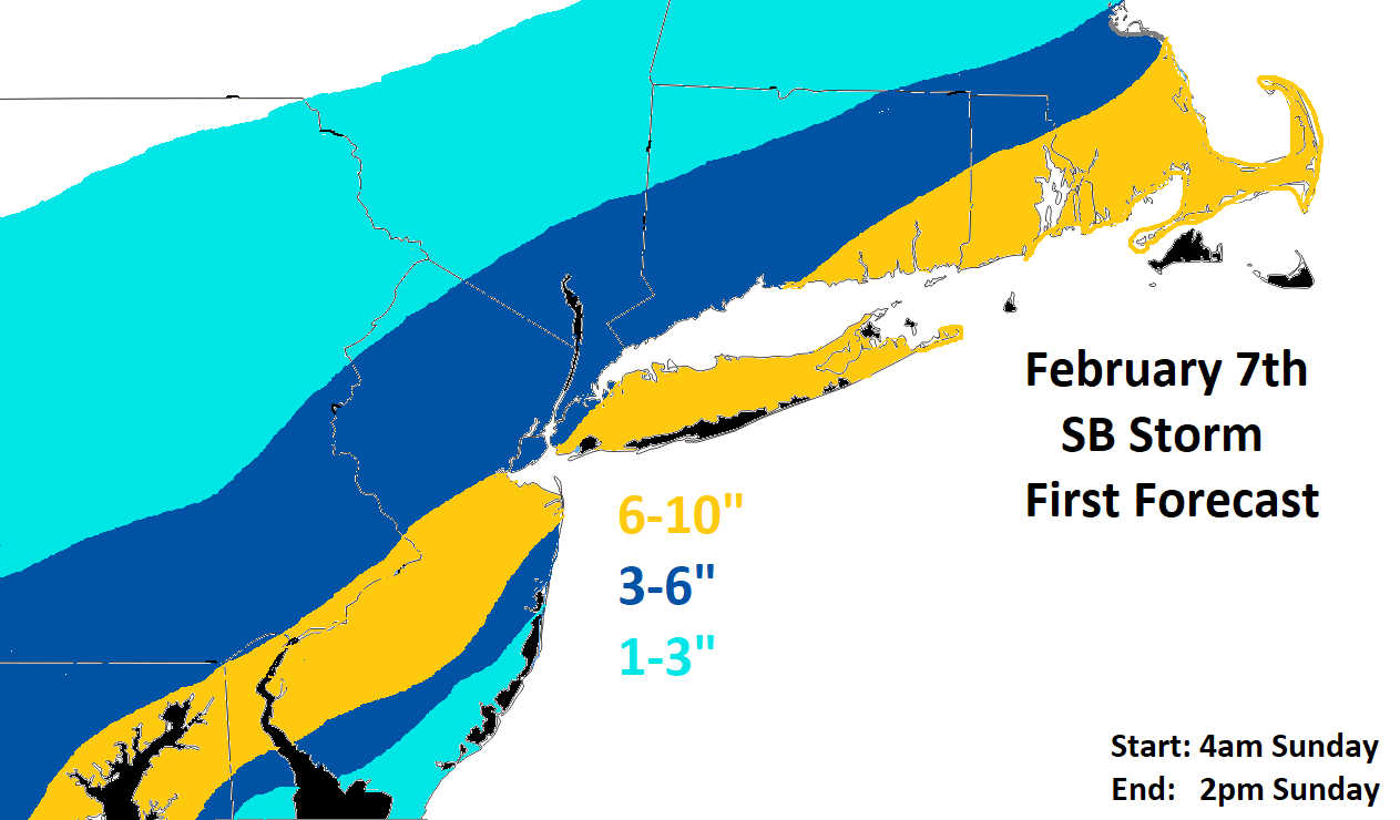
WSW for city for 5-7. Hoping they’re being a little conservative with that and they can get in 6- 9 range. Nitpicking I Know.

CPcantmeasuresnow- Wx Statistician Guru

- Posts : 7274
Reputation : 230
Join date : 2013-01-07
Age : 103
Location : Eastern Orange County, NY
Re: Super Bowl Snowstorm, Part II: First Call
![]() by docstox12 Sat Feb 06, 2021 6:18 am
by docstox12 Sat Feb 06, 2021 6:18 am
CPcantmeasuresnow wrote:WWA for Orange County For 3-6. Sounds a little optimistic but I’ll take it.
WSW for city for 5-7. Hoping they’re being a little conservative with that and they can get in 6- 9 range. Nitpicking I Know.
24 degrees.Latest GFS shows around four for us CP.WWA for 3 to 6, so maybe a chance for better.We are closer to a normal years snowfall here in the HV, so much better than last year.

docstox12- Wx Statistician Guru
- Posts : 8530
Reputation : 222
Join date : 2013-01-07
Age : 73
Location : Monroe NY
CPcantmeasuresnow likes this post
Re: Super Bowl Snowstorm, Part II: First Call
![]() by Snow88 Sat Feb 06, 2021 6:32 am
by Snow88 Sat Feb 06, 2021 6:32 am
Snow88- Senior Enthusiast
- Posts : 2193
Reputation : 4
Join date : 2013-01-09
Age : 35
Location : Brooklyn, NY
Page 1 of 14 • 1, 2, 3 ... 7 ... 14 ![]()
|
|
|