
 Search
Super Bowl Snowstorm, Part II: First Call
Page 2 of 14 •  1, 2, 3 ... 8 ... 14
 ![]()
Re: Super Bowl Snowstorm, Part II: First Call
![]() by docstox12 Sat Feb 06, 2021 6:18 am
by docstox12 Sat Feb 06, 2021 6:18 am
CPcantmeasuresnow wrote:WWA for Orange County For 3-6. Sounds a little optimistic but I’ll take it.
WSW for city for 5-7. Hoping they’re being a little conservative with that and they can get in 6- 9 range. Nitpicking I Know.
24 degrees.Latest GFS shows around four for us CP.WWA for 3 to 6, so maybe a chance for better.We are closer to a normal years snowfall here in the HV, so much better than last year.
docstox12- Wx Statistician Guru

- Posts : 8530
Join date : 2013-01-07
CPcantmeasuresnow likes this post
Re: Super Bowl Snowstorm, Part II: First Call
![]() by Snow88 Sat Feb 06, 2021 6:32 am
by Snow88 Sat Feb 06, 2021 6:32 am
Snow88- Senior Enthusiast

- Posts : 2193
Join date : 2013-01-09
Re: Super Bowl Snowstorm, Part II: First Call
![]() by Taffy Sat Feb 06, 2021 7:37 am
by Taffy Sat Feb 06, 2021 7:37 am

Taffy- Pro Enthusiast

- Posts : 530
Reputation : 19
Join date : 2013-10-06
Location : Hopkinton, MA
Re: Super Bowl Snowstorm, Part II: First Call
![]() by Frank_Wx Sat Feb 06, 2021 8:15 am
by Frank_Wx Sat Feb 06, 2021 8:15 am


_________________
_______________________________________________________________________________________________________
CLICK HERE to view NJ Strong Snowstorm Classifications

Frank_Wx- Godzilla Seeker

- Posts : 21305
Reputation : 328
Join date : 2013-01-05
Age : 32
Location : Jersey City, NJ -

weatherwatchermom likes this post
Re: Super Bowl Snowstorm, Part II: First Call
![]() by heehaw453 Sat Feb 06, 2021 9:11 am
by heehaw453 Sat Feb 06, 2021 9:11 am

heehaw453- Advanced Forecaster

- Posts : 3906
Reputation : 86
Join date : 2014-01-20
Location : Bedminster Township, PA Elevation 600' ASL
Re: Super Bowl Snowstorm, Part II: First Call
![]() by amugs Sat Feb 06, 2021 9:37 am
by amugs Sat Feb 06, 2021 9:37 am

_________________
Mugs
AKA:King: Snow Weenie
Self Proclaimed
WINTER 2014-15 : 55.12" +.02 for 6 coatings (avg. 35")
WINTER 2015-16 Total - 29.8" (Avg 35")
WINTER 2016-17 : 39.5" so far

amugs- Advanced Forecaster - Mod

- Posts : 15095
Reputation : 213
Join date : 2013-01-07
Age : 54
Location : Hillsdale,NJ
Taffy likes this post
Re: Super Bowl Snowstorm, Part II: First Call
![]() by amugs Sat Feb 06, 2021 9:40 am
by amugs Sat Feb 06, 2021 9:40 am

_________________
Mugs
AKA:King: Snow Weenie
Self Proclaimed
WINTER 2014-15 : 55.12" +.02 for 6 coatings (avg. 35")
WINTER 2015-16 Total - 29.8" (Avg 35")
WINTER 2016-17 : 39.5" so far
amugs- Advanced Forecaster - Mod
- Posts : 15095
Reputation : 213
Join date : 2013-01-07
Age : 54
Location : Hillsdale,NJ
CPcantmeasuresnow likes this post
Re: Super Bowl Snowstorm, Part II: First Call
![]() by amugs Sat Feb 06, 2021 9:41 am
by amugs Sat Feb 06, 2021 9:41 am
_________________
Mugs
AKA:King: Snow Weenie
Self Proclaimed
WINTER 2014-15 : 55.12" +.02 for 6 coatings (avg. 35")
WINTER 2015-16 Total - 29.8" (Avg 35")
WINTER 2016-17 : 39.5" so far
amugs- Advanced Forecaster - Mod
- Posts : 15095
Reputation : 213
Join date : 2013-01-07
Age : 54
Location : Hillsdale,NJ
weatherwatchermom likes this post
Re: Super Bowl Snowstorm, Part II: First Call
![]() by billg315 Sat Feb 06, 2021 9:47 am
by billg315 Sat Feb 06, 2021 9:47 am

billg315- Advanced Forecaster - Mod
- Posts : 4483
Reputation : 185
Join date : 2015-01-24
Age : 50
Location : Flemington, NJ
weatherwatchermom likes this post
Re: Super Bowl Snowstorm, Part II: First Call
![]() by amugs Sat Feb 06, 2021 9:50 am
by amugs Sat Feb 06, 2021 9:50 am

_________________
Mugs
AKA:King: Snow Weenie
Self Proclaimed
WINTER 2014-15 : 55.12" +.02 for 6 coatings (avg. 35")
WINTER 2015-16 Total - 29.8" (Avg 35")
WINTER 2016-17 : 39.5" so far
amugs- Advanced Forecaster - Mod
- Posts : 15095
Reputation : 213
Join date : 2013-01-07
Age : 54
Location : Hillsdale,NJ
Re: Super Bowl Snowstorm, Part II: First Call
![]() by billg315 Sat Feb 06, 2021 10:08 am
by billg315 Sat Feb 06, 2021 10:08 am
billg315- Advanced Forecaster - Mod
- Posts : 4483
Reputation : 185
Join date : 2015-01-24
Age : 50
Location : Flemington, NJ
Frank_Wx, kalleg, brownie, Lauraanne2, Vinnydula, Mobodato, weatherwatchermom and Bwtr like this post
Re: Super Bowl Snowstorm, Part II: First Call
![]() by billg315 Sat Feb 06, 2021 10:59 am
by billg315 Sat Feb 06, 2021 10:59 am
billg315- Advanced Forecaster - Mod
- Posts : 4483
Reputation : 185
Join date : 2015-01-24
Age : 50
Location : Flemington, NJ
Re: Super Bowl Snowstorm, Part II: First Call
![]() by Fededle22 Sat Feb 06, 2021 1:20 pm
by Fededle22 Sat Feb 06, 2021 1:20 pm
Fededle22- Posts : 169
Reputation : 2
Join date : 2013-03-08
Location : West Orange, NJ
Re: Super Bowl Snowstorm, Part II: First Call
![]() by Frank_Wx Sat Feb 06, 2021 1:24 pm
by Frank_Wx Sat Feb 06, 2021 1:24 pm
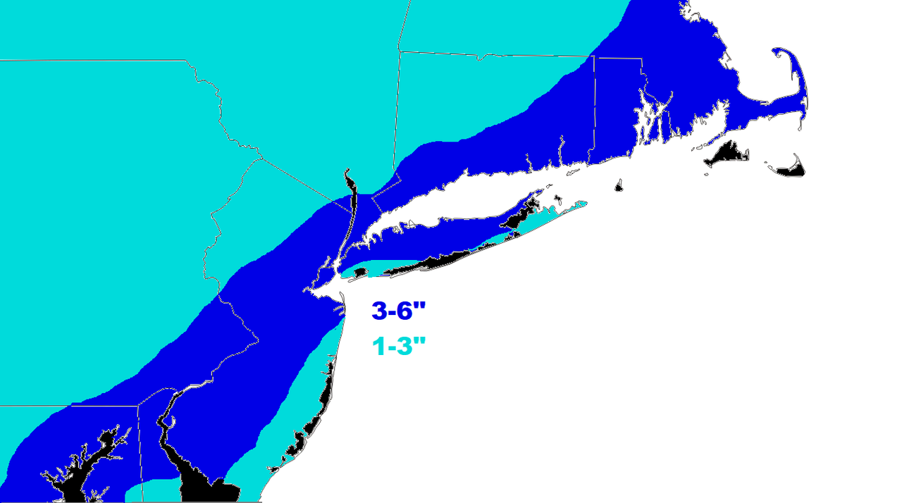
Fededle22 wrote:Very quiet here considering we have a storm impacting the area tomorrow morning. I guess it has been resolved that it is not going to be as much snow as previously thought? Are we still looking at a 6am start time? 4-6 inches by me?
It’s a sunny and warm day! I will have my final forecast out in a couple of hours. Here’s the EURO

The sun feels pretty strong and this storm is coming in the middle of the day. I will definitely be cutting the 6-10 zone...likely in half.
_________________
_______________________________________________________________________________________________________
CLICK HERE to view NJ Strong Snowstorm Classifications
Frank_Wx- Godzilla Seeker
- Posts : 21305
Reputation : 328
Join date : 2013-01-05
Age : 32
Location : Jersey City, NJ -
Re: Super Bowl Snowstorm, Part II: First Call
![]() by CPcantmeasuresnow Sat Feb 06, 2021 2:30 pm
by CPcantmeasuresnow Sat Feb 06, 2021 2:30 pm

CPcantmeasuresnow- Wx Statistician Guru
- Posts : 7274
Reputation : 230
Join date : 2013-01-07
Age : 103
Location : Eastern Orange County, NY
Re: Super Bowl Snowstorm, Part II: First Call
![]() by skinsfan1177 Sat Feb 06, 2021 2:59 pm
by skinsfan1177 Sat Feb 06, 2021 2:59 pm

skinsfan1177- Senior Enthusiast
- Posts : 4485
Reputation : 35
Join date : 2013-01-07
Age : 46
Location : Point Pleasant Boro
amugs likes this post
Re: Super Bowl Snowstorm, Part II: First Call
![]() by Irish Sat Feb 06, 2021 3:18 pm
by Irish Sat Feb 06, 2021 3:18 pm
Frank_Wx wrote:Fededle22 wrote:Very quiet here considering we have a storm impacting the area tomorrow morning. I guess it has been resolved that it is not going to be as much snow as previously thought? Are we still looking at a 6am start time? 4-6 inches by me?
It’s a sunny and warm day! I will have my final forecast out in a couple of hours. Here’s the EURO
The sun feels pretty strong and this storm is coming in the middle of the day. I will definitely be cutting the 6-10 zone...likely in half.
Good idea, all other outlets have done the same.

Irish- Pro Enthusiast
- Posts : 788
Reputation : 19
Join date : 2019-01-16
Age : 45
Location : Old Bridge, NJ
Re: Super Bowl Snowstorm, Part II: First Call
![]() by Frank_Wx Sat Feb 06, 2021 3:47 pm
by Frank_Wx Sat Feb 06, 2021 3:47 pm
_________________
_______________________________________________________________________________________________________
CLICK HERE to view NJ Strong Snowstorm Classifications
Frank_Wx- Godzilla Seeker
- Posts : 21305
Reputation : 328
Join date : 2013-01-05
Age : 32
Location : Jersey City, NJ -
billg315 likes this post
Re: Super Bowl Snowstorm, Part II: First Call
![]() by heehaw453 Sat Feb 06, 2021 4:12 pm
by heehaw453 Sat Feb 06, 2021 4:12 pm
heehaw453- Advanced Forecaster
- Posts : 3906
Reputation : 86
Join date : 2014-01-20
Location : Bedminster Township, PA Elevation 600' ASL
Re: Super Bowl Snowstorm, Part II: First Call
![]() by amugs Sat Feb 06, 2021 4:28 pm
by amugs Sat Feb 06, 2021 4:28 pm
Upton even talks about about tjis in their latest update . Here's E
 A little agreesive the 5-9" I'd say 4-8" but splitting hairs.
Upton:
One concern with the global models is that they are
not handling the banding potential well and are over smoothing the
liquid equivalent amounts. The GFS shows excellent lift in the
dendritic growth zone (-12C to -18C) even as far north as the Lower
Hudson Valley where current forecast liquid amounts are lower.
Frontogenesis on the NW side or colder side of the middle level low
is impressive for about a 3-6 hour period from late morning into the
afternoon across much of the region. The mesoscale models agree with
this lift, but are stronger in magnitude and therefore higher in
snowfall/banding potential.
Basically saying we are going with SR models like the NAMs.
_________________
Mugs
AKA:King: Snow Weenie
Self Proclaimed
WINTER 2014-15 : 55.12" +.02 for 6 coatings (avg. 35")
WINTER 2015-16 Total - 29.8" (Avg 35")
WINTER 2016-17 : 39.5" so far
amugs- Advanced Forecaster - Mod
- Posts : 15095
Reputation : 213
Join date : 2013-01-07
Age : 54
Location : Hillsdale,NJ
Re: Super Bowl Snowstorm, Part II: First Call
![]() by amugs Sat Feb 06, 2021 4:53 pm
by amugs Sat Feb 06, 2021 4:53 pm

_________________
Mugs
AKA:King: Snow Weenie
Self Proclaimed
WINTER 2014-15 : 55.12" +.02 for 6 coatings (avg. 35")
WINTER 2015-16 Total - 29.8" (Avg 35")
WINTER 2016-17 : 39.5" so far
amugs- Advanced Forecaster - Mod
- Posts : 15095
Reputation : 213
Join date : 2013-01-07
Age : 54
Location : Hillsdale,NJ
Re: Super Bowl Snowstorm, Part II: First Call
![]() by jmanley32 Sat Feb 06, 2021 5:18 pm
by jmanley32 Sat Feb 06, 2021 5:18 pm
NWS is taking only SR models, I think we see the higher end of 3-6 and some spots higher than that. Only place NWS disagrees with franks bap is suffolk county and eadtern CT to beantown could see 6 to 9. If the storm blows up just a bit quicker some of us from NYC on east could see 6-9 IMO just going by SR models. mugs whats the href? or was that your code again for SREF?amugs wrote:HREF ensemble is impressive but overdone is day? Based on WRF and NMB weightings?

jmanley32- Senior Enthusiast
- Posts : 20535
Reputation : 108
Join date : 2013-12-12
Age : 43
Location : Yonkers, NY
Re: Super Bowl Snowstorm, Part II: First Call
![]() by jmanley32 Sat Feb 06, 2021 5:19 pm
by jmanley32 Sat Feb 06, 2021 5:19 pm
For my area anyways spot on with my winter storm warning, 5-9.amugs wrote:The convection has formed is far far greater and showing the latent heat response to the jet and the forcing. Models have not shown tjis convection well except for the NAM models.
Upton even talks about about tjis in their latest update . Here's EA little agreesive the 5-9" I'd say 4-8" but splitting hairs.
Upton:
One concern with the global models is that they are
not handling the banding potential well and are over smoothing the
liquid equivalent amounts. The GFS shows excellent lift in the
dendritic growth zone (-12C to -18C) even as far north as the Lower
Hudson Valley where current forecast liquid amounts are lower.
Frontogenesis on the NW side or colder side of the middle level low
is impressive for about a 3-6 hour period from late morning into the
afternoon across much of the region. The mesoscale models agree with
this lift, but are stronger in magnitude and therefore higher in
snowfall/banding potential.
Basically saying we are going with SR models like the NAMs.
jmanley32- Senior Enthusiast
- Posts : 20535
Reputation : 108
Join date : 2013-12-12
Age : 43
Location : Yonkers, NY
Re: Super Bowl Snowstorm, Part II: First Call
![]() by jmanley32 Sat Feb 06, 2021 5:21 pm
by jmanley32 Sat Feb 06, 2021 5:21 pm
yeah people are out and about, I guess it was nice I missed out. Tonight I think the posts will start especially with the observations and nowcasting starting, we are already as stated seeing stronger convection to the south than was expected by this time stamp, i think there may be surprises for some.Fededle22 wrote:Very quiet here considering we have a storm impacting the area tomorrow morning. I guess it has been resolved that it is not going to be as much snow as previously thought? Are we still looking at a 6am start time? 4-6 inches by me?
jmanley32- Senior Enthusiast
- Posts : 20535
Reputation : 108
Join date : 2013-12-12
Age : 43
Location : Yonkers, NY
Re: Super Bowl Snowstorm, Part II: First Call
![]() by amugs Sat Feb 06, 2021 5:45 pm
by amugs Sat Feb 06, 2021 5:45 pm

_________________
Mugs
AKA:King: Snow Weenie
Self Proclaimed
WINTER 2014-15 : 55.12" +.02 for 6 coatings (avg. 35")
WINTER 2015-16 Total - 29.8" (Avg 35")
WINTER 2016-17 : 39.5" so far
amugs- Advanced Forecaster - Mod
- Posts : 15095
Reputation : 213
Join date : 2013-01-07
Age : 54
Location : Hillsdale,NJ
Re: Super Bowl Snowstorm, Part II: First Call
![]() by Frank_Wx Sat Feb 06, 2021 6:16 pm
by Frank_Wx Sat Feb 06, 2021 6:16 pm
_________________
_______________________________________________________________________________________________________
CLICK HERE to view NJ Strong Snowstorm Classifications
Frank_Wx- Godzilla Seeker
- Posts : 21305
Reputation : 328
Join date : 2013-01-05
Age : 32
Location : Jersey City, NJ -
Re: Super Bowl Snowstorm, Part II: First Call
![]() by Frank_Wx Sat Feb 06, 2021 6:22 pm
by Frank_Wx Sat Feb 06, 2021 6:22 pm
_________________
_______________________________________________________________________________________________________
CLICK HERE to view NJ Strong Snowstorm Classifications
Frank_Wx- Godzilla Seeker
- Posts : 21305
Reputation : 328
Join date : 2013-01-05
Age : 32
Location : Jersey City, NJ -
Page 2 of 14 • 1, 2, 3 ... 8 ... 14 ![]()
|
|
|