Thursday, 02/18: The Next One
+11
mmanisca
aiannone
SNOW MAN
sabamfa
jmanley32
nutleyblizzard
amugs
billg315
heehaw453
SENJsnowman
Frank_Wx
15 posters
Page 3 of 5 •  1, 2, 3, 4, 5
 Re: Thursday, 02/18: The Next One
I think Euro is underdoing the WAA frontogenesis a bit. Mesos will be best at determining how far north it gets. This will be a longer duration event because you have the initial WAA and then precip from the developing storm. If that coastal cranks a bit that can surprise with higher amounts.
heehaw453- Advanced Forecaster

- Posts : 3906
Join date : 2014-01-20
 Re: Thursday, 02/18: The Next One
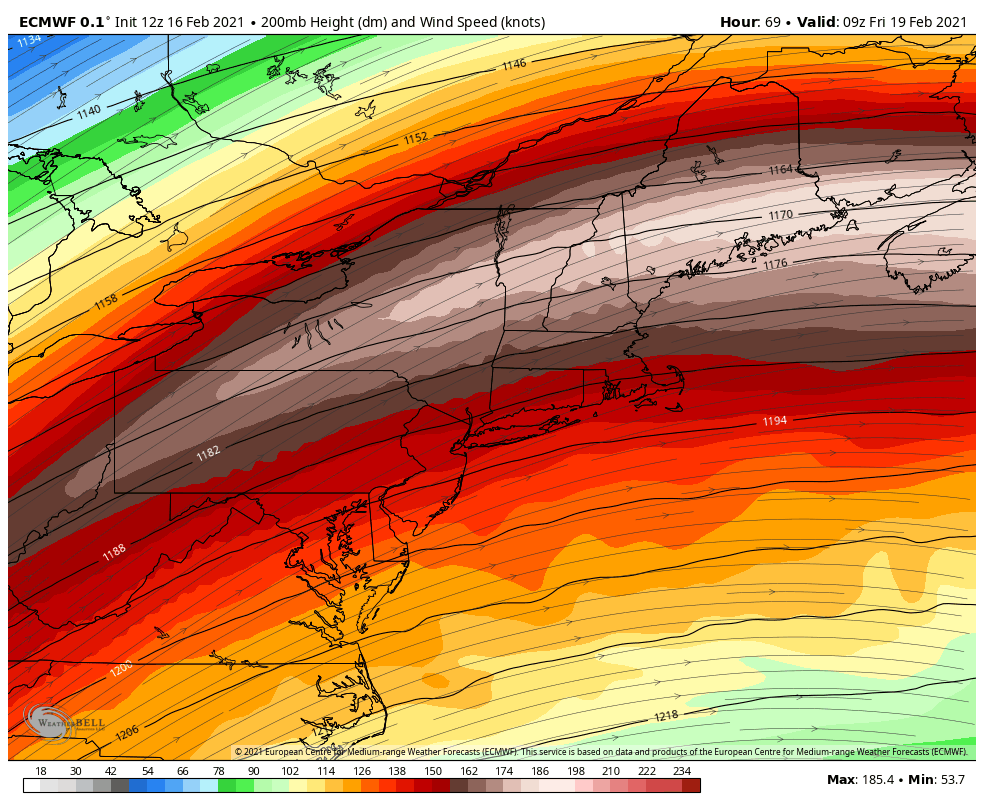
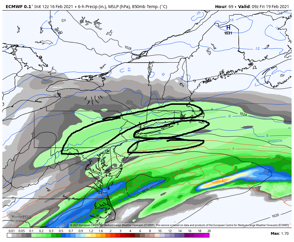
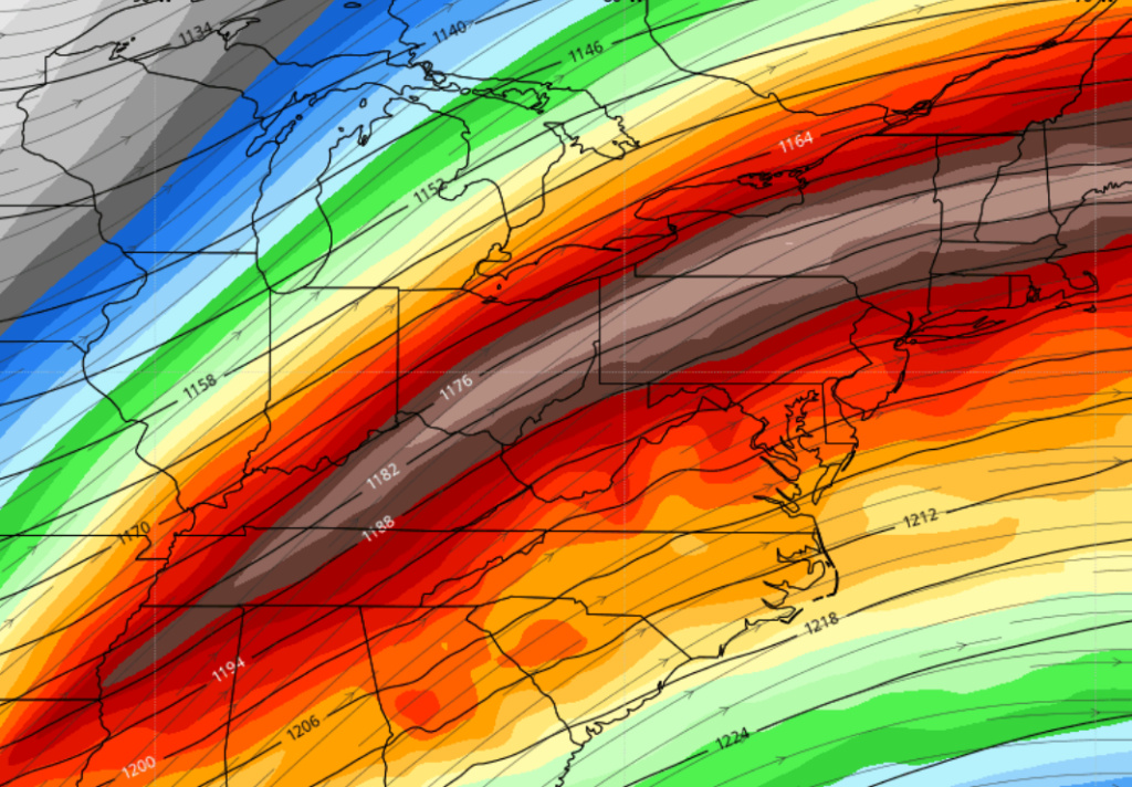
Energy slides a little south on this Euro run. Puts heaviest snow right across central and southern NJ as the secondary tries to develop off the VA coast. I wonder if this is legit because of the strong high pressure planted to the north, or if this will simply waffle back with the typical NW trend in the final 24 hours as we've been seeing all winter.
billg315- Advanced Forecaster - Mod

- Posts : 4483
Join date : 2015-01-24
 Re: Thursday, 02/18: The Next One
_________________
-Alex Iannone-

aiannone- Senior Enthusiast - Mod

- Posts : 4815
Reputation : 92
Join date : 2013-01-07
Location : Saint James, LI (Northwest Suffolk Co.)
 Re: Thursday, 02/18: The Next One
Upper air energy on the Euro was shifted a bit south from last run. The heaviest snow axis here is a bit south of what the NAM was showing. This is good news in that it shows the cold air is hanging tough and not budging with all that high pressure to our north. question is will that also keep the heaviest snows suppressed to SNJ and CNJ, or will we see the now common NW shift tomorrow and see that heaviest snow across NNJ and NYC?

billg315- Advanced Forecaster - Mod

- Posts : 4483
Reputation : 185
Join date : 2015-01-24
Age : 50
Location : Flemington, NJ
 Re: Thursday, 02/18: The Next One
billg315 wrote:Energy slides a little south on this Euro run. Puts heaviest snow right across central and southern NJ as the secondary tries to develop off the VA coast. I wonder if this is legit because of the strong high pressure planted to the north, or if this will simply waffle back with the typical NW trend in the final 24 hours as we've been seeing all winter.
And at that moment, SENJ knew that the hunt was on...
SENJsnowman- Senior Enthusiast

- Posts : 1189
Reputation : 61
Join date : 2017-01-06
Age : 51
Location : Bayville, NJ
 Re: Thursday, 02/18: The Next One
_________________
"In weather and in life, there's no winning and losing; there's only winning and learning."
WINTER 2012/2013 TOTALS 43.65"WINTER 2017/2018 TOTALS 62.85" WINTER 2022/2023 TOTALS 4.9"
WINTER 2013/2014 TOTALS 64.85"WINTER 2018/2019 TOTALS 14.25" WINTER 2023/2024 TOTALS 13.1"
WINTER 2014/2015 TOTALS 71.20"WINTER 2019/2020 TOTALS 6.35"
WINTER 2015/2016 TOTALS 35.00"WINTER 2020/2021 TOTALS 37.75"
WINTER 2016/2017 TOTALS 42.25"WINTER 2021/2022 TOTALS 31.65"

sroc4- Admin

- Posts : 8354
Reputation : 302
Join date : 2013-01-07
Location : Wading River, LI
CPcantmeasuresnow likes this post
 Re: Thursday, 02/18: The Next One
jmanley32 wrote:
not sure how far south you are but good snows into central southern nj. In fact on gfs that area jackpots with 8 to 10 verbatim. Anything 6 plus is good to me and that looks very possible with this one.
JMan, absolutely man, as of now, I'm looking great now for a sweet front end thump of up to say 6" or even a bit more and VERY grateful to be in that position. And it's scheduled to start pre-dawn and crank throughout the whole morning and on into the early afternoon. According to Mt Holly, we aren't looking at the first change to mix until at least 1 pm first and then a change to rain around 4 pm with a disappointing .5"+ of rain Thursday night and into Friday. If that happens verbatim, this would probably still be the BEST storm all year imby and would make Thursday yet another majestic day to go with the 2-3 awesome snow days we've already had. Now, we're not talking about the kind of production that Irish or heehaw or Mugs or you have gotten out of this winter, but just this morning my 10 year old did say that this winter there has been 'so much snow.' So, for sure I'm quite half full about it all!
So, with all that said, at the moment I am 'determined to prevent' the change over to rain. I want a full blown storm beginning to end. 8-12" of snow with no rain!!! Any chance? I think so. High chance? No way, it's quite small in fact. Growing chance? Oh yeah, it's doubled in the past 24 hrs. As of this morning, I thought your neck of the woods looked like the r/s battle zone, but now it seems to have shifted further south, and so has the heavier precip axis. I'm not sure if a further SE trend imperils the front end thump or not and I'm not sure if it's even possible at this point for the coast to stay all snow, but here we are, approaching game time and still in the hunt!
I think using the CP playbook here, the 12z runs tonight should have the best handle as this present storm will be out of the way and we'll see if the heretofore reliable 'nw tick' materializes as Bill suggested. If that happens, we're obviously done down here in Ocean County as far as staying all snow. But I think even then, we still see 3-5" of good early and late morning snow.
SENJsnowman- Senior Enthusiast

- Posts : 1189
Reputation : 61
Join date : 2017-01-06
Age : 51
Location : Bayville, NJ
jmanley32 likes this post
 Re: Thursday, 02/18: The Next One
Well I'm rooting for you but also am hoping to get a good 6 inches hopefully. If not so be it. As you said we got our 22 inch storm which far surpasses any storm we have had in a long time. You need get out of there and come north like CP keeps telling me to move north of Westchester, NY LOL. It may happen one day but for now our weather happens here just not as often and it is to be expected. Lets see what models do. Any further SE or S track will bring down totals up here but def give you a run for getting the goods. I think we all know we all want the goods though lolSENJsnowman wrote:jmanley32 wrote:
not sure how far south you are but good snows into central southern nj. In fact on gfs that area jackpots with 8 to 10 verbatim. Anything 6 plus is good to me and that looks very possible with this one.
JMan, absolutely man, as of now, I'm looking great now for a sweet front end thump of up to say 6" or even a bit more and VERY grateful to be in that position. And it's scheduled to start pre-dawn and crank throughout the whole morning and on into the early afternoon. According to Mt Holly, we aren't looking at the first change to mix until at least 1 pm first and then a change to rain around 4 pm with a disappointing .5"+ of rain Thursday night and into Friday. If that happens verbatim, this would probably still be the BEST storm all year imby and would make Thursday yet another majestic day to go with the 2-3 awesome snow days we've already had. Now, we're not talking about the kind of production that Irish or heehaw or Mugs or you have gotten out of this winter, but just this morning my 10 year old did say that this winter there has been 'so much snow.' So, for sure I'm quite half full about it all!
So, with all that said, at the moment I am 'determined to prevent' the change over to rain. I want a full blown storm beginning to end. 8-12" of snow with no rain!!! Any chance? I think so. High chance? No way, it's quite small in fact. Growing chance? Oh yeah, it's doubled in the past 24 hrs. As of this morning, I thought your neck of the woods looked like the r/s battle zone, but now it seems to have shifted further south, and so has the heavier precip axis. I'm not sure if a further SE trend imperils the front end thump or not and I'm not sure if it's even possible at this point for the coast to stay all snow, but here we are, approaching game time and still in the hunt!
I think using the CP playbook here, the 12z runs tonight should have the best handle as this present storm will be out of the way and we'll see if the heretofore reliable 'nw tick' materializes as Bill suggested. If that happens, we're obviously done down here in Ocean County as far as staying all snow. But I think even then, we still see 3-5" of good early and late morning snow.

jmanley32- Senior Enthusiast

- Posts : 20535
Reputation : 108
Join date : 2013-12-12
Age : 43
Location : Yonkers, NY
 Re: Thursday, 02/18: The Next One
aiannone wrote:Expect watches to go up at the 4pm update. Great way to finish off an ugly day. WE WILL REBUILD
Right on cue Alex. Mt. Holly:
..WINTER STORM WATCH IN EFFECT FROM LATE WEDNESDAY NIGHT THROUGHFRIDAY AFTERNOON...
* WHAT...Heavy mixed precipitation possible. Total snow and sleet accumulations of 5 to 8 inches.
* WHERE...Portions of northern and northwest New Jersey and east central, northeast and southeast Pennsylvania.
* WHEN...From late Wednesday night through Friday afternoon.
* IMPACTS...Travel could be very difficult. The hazardous conditions could impact the morning or evening commute.
* ADDITIONAL DETAILS...Precipitation will begin as snow Thursday morning, with the heaviest snowfall expected Thursday morning into early Thursday afternoon. Sleet and/or freezing rain may then mix in Thursday evening into Thursday night. Light wintry precipitation will likely continue into the daytime hours on Friday. PRECAUTIONARY/PREPAREDNESS ACTIONS... Monitor the latest forecasts for updates on this situation.

billg315- Advanced Forecaster - Mod

- Posts : 4483
Reputation : 185
Join date : 2015-01-24
Age : 50
Location : Flemington, NJ
 Re: Thursday, 02/18: The Next One
Just a HWO right now, says potential for significant snow, I bet Upton waits till tomorrow knowing them.

jmanley32- Senior Enthusiast

- Posts : 20535
Reputation : 108
Join date : 2013-12-12
Age : 43
Location : Yonkers, NY
 Re: Thursday, 02/18: The Next One
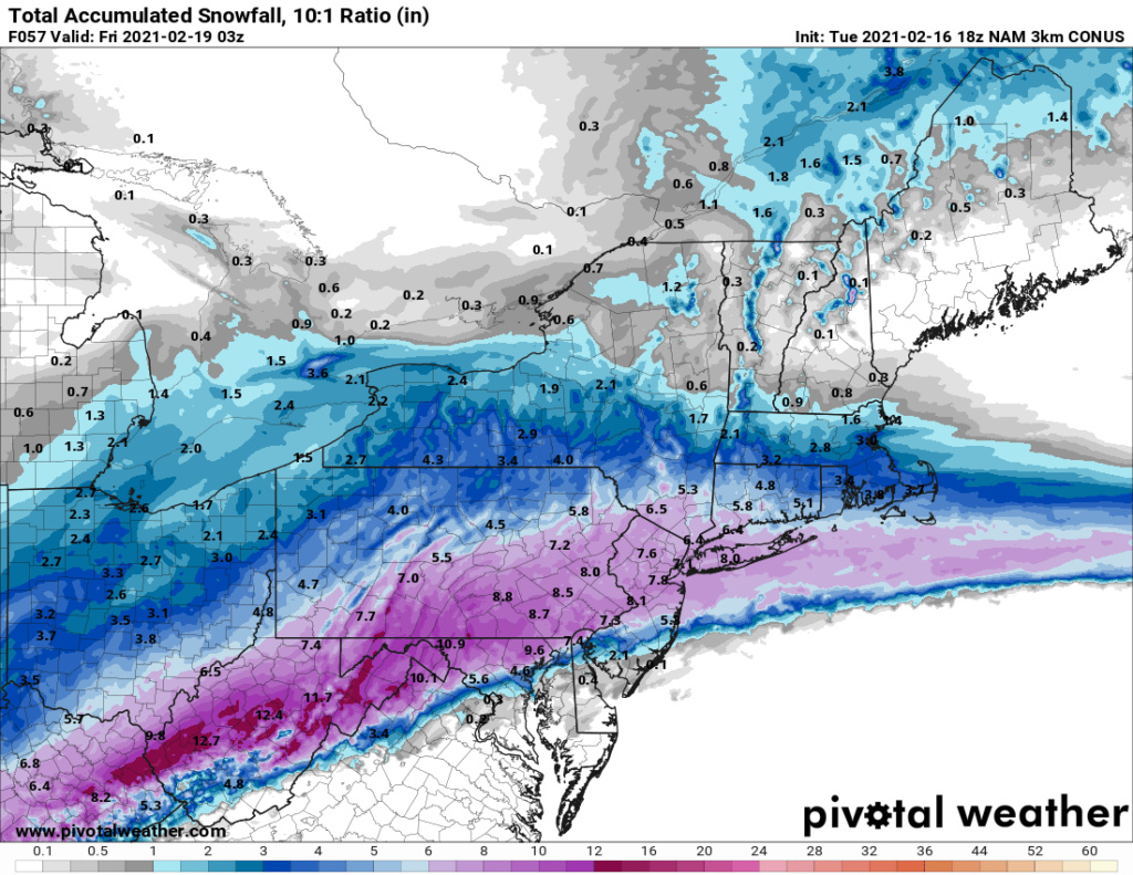
18Z NAM is quite cold. mid 20's for the heart of the snowfall through NYC LI and NNJ
_________________
-Alex Iannone-

aiannone- Senior Enthusiast - Mod

- Posts : 4815
Reputation : 92
Join date : 2013-01-07
Location : Saint James, LI (Northwest Suffolk Co.)
 Re: Thursday, 02/18: The Next One
So, no wsw yet from Mt Holly for Southern NJ, but I bet it's probably coming with their 4 pm update as well.
Still, the language they are using is sooooo much more snow friendly than what I'm used to. They even talk about the nice "front-end thump"! I did also put in bold the mention of a more nw push of the warm nose due to the track of the ull, as per the NAM. Still the favored result, unfortunately.
The trend over the last couple of days has been colder with
this system with the East Coast ridge trending flatter and the
northern high trending stronger. Consequently this setup would
likely result in a general thump of snow Thursday morning into
early Thursday afternoon, before warmer air arrives aloft and we
see precipitation types transition from south to north to
sleet/freezing rain/rain Thursday afternoon into Thursday night.
The main questions are how long-lasting and powerful that
initial thump of snow is, and also how quickly the column warms.
The NAM in particular shows a band of robust 700-850 MB
frontogenesis (FGEN) lifting across the area in the warm air
advection regime. This along with increasing upper- level
divergence in the right entrance region of the northern jet
would tend to result in a zone of moderate to heavy snow (front-
end thump) when many locations could quickly pick up several
inches of snow on Thursday. Given the robust cold air damming
setup, would not be surprised if many locations northwest of
I-95 never get above freezing and thus see only frozen
precipitation during the entirety of the event.
The model guidance mainly shows the burst of snow overspreading
much of the area Thursday morning, then a wintry mix develops
into the I- 95 corridor. Some guidance has the mixing farther
northwestward however. Given the track of the surface low and
the cold air damming signature, we continued the inland movement
of the wintry mix even into the Lehigh Valley for a time. The
NAM is warmer aloft farther northwest as it hangs onto a weak
primary low into northwest Pennsylvania longer and has the
secondary low along or just inland from the southeastern New
Jersey coast. The farther northwest warming aloft from the NAM
was not completely discounted as we may have to watch for any
northwest shift in the storm track (secondary low development
closer to the coast), which has happened many times this winter.
Given the synoptic setup though with the strong high to our
north which gradually shifts east, the secondary surface low may
not have much space to trend northwestward. At this time,
warning criteria snow is quite possible for at least a portion
of the region and a Winter Storm Watch will probably be needed
by late today.
The storm while deepening some will track northeastward and
away from our area Friday. There should be some lingering wrap-
around snow or wintry mix across about the northern half of our
area to start Friday, otherwise improving conditions are
anticipated with probably some sunshine returning for the
afternoon under a brisk northwesterly wind.
Still, the language they are using is sooooo much more snow friendly than what I'm used to. They even talk about the nice "front-end thump"!
The trend over the last couple of days has been colder with
this system with the East Coast ridge trending flatter and the
northern high trending stronger. Consequently this setup would
likely result in a general thump of snow Thursday morning into
early Thursday afternoon, before warmer air arrives aloft and we
see precipitation types transition from south to north to
sleet/freezing rain/rain Thursday afternoon into Thursday night.
The main questions are how long-lasting and powerful that
initial thump of snow is, and also how quickly the column warms.
The NAM in particular shows a band of robust 700-850 MB
frontogenesis (FGEN) lifting across the area in the warm air
advection regime. This along with increasing upper- level
divergence in the right entrance region of the northern jet
would tend to result in a zone of moderate to heavy snow (front-
end thump) when many locations could quickly pick up several
inches of snow on Thursday. Given the robust cold air damming
setup, would not be surprised if many locations northwest of
I-95 never get above freezing and thus see only frozen
precipitation during the entirety of the event.
The model guidance mainly shows the burst of snow overspreading
much of the area Thursday morning, then a wintry mix develops
into the I- 95 corridor. Some guidance has the mixing farther
northwestward however. Given the track of the surface low and
the cold air damming signature, we continued the inland movement
of the wintry mix even into the Lehigh Valley for a time. The
NAM is warmer aloft farther northwest as it hangs onto a weak
primary low into northwest Pennsylvania longer and has the
secondary low along or just inland from the southeastern New
Jersey coast. The farther northwest warming aloft from the NAM
was not completely discounted as we may have to watch for any
northwest shift in the storm track (secondary low development
closer to the coast), which has happened many times this winter.
Given the synoptic setup though with the strong high to our
north which gradually shifts east, the secondary surface low may
not have much space to trend northwestward. At this time,
warning criteria snow is quite possible for at least a portion
of the region and a Winter Storm Watch will probably be needed
by late today.
The storm while deepening some will track northeastward and
away from our area Friday. There should be some lingering wrap-
around snow or wintry mix across about the northern half of our
area to start Friday, otherwise improving conditions are
anticipated with probably some sunshine returning for the
afternoon under a brisk northwesterly wind.
SENJsnowman- Senior Enthusiast

- Posts : 1189
Reputation : 61
Join date : 2017-01-06
Age : 51
Location : Bayville, NJ
larryrock72 likes this post
 Re: Thursday, 02/18: The Next One
aiannone wrote:18Z NAM is quite cold. mid 20's for the heart of the snowfall through NYC LI and NNJ
the 850s don't get above freezing until around midnight Thursday into Friday, but even then the surface is below freezing still for all but the SNJ coast.

billg315- Advanced Forecaster - Mod

- Posts : 4483
Reputation : 185
Join date : 2015-01-24
Age : 50
Location : Flemington, NJ
 Re: Thursday, 02/18: The Next One
WOW 18z NAM!!

jmanley32- Senior Enthusiast

- Posts : 20535
Reputation : 108
Join date : 2013-12-12
Age : 43
Location : Yonkers, NY
 Re: Thursday, 02/18: The Next One
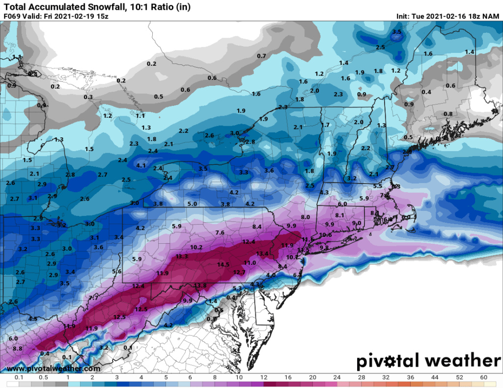
NAM has 8-12" of snow from I-195 in central NJ north before a change to sleet early Friday morning. SNJ gets a couple quick inches then a sleet onslaught. 2-3" of SLEET. That is a lot of sleet.

billg315- Advanced Forecaster - Mod

- Posts : 4483
Reputation : 185
Join date : 2015-01-24
Age : 50
Location : Flemington, NJ
 Re: Thursday, 02/18: The Next One
High end Mothra in NYC area if NAM is right verbatim. Won't be but this looks great, SNJsnowman how far south are you do you miss the bigger snows?

jmanley32- Senior Enthusiast

- Posts : 20535
Reputation : 108
Join date : 2013-12-12
Age : 43
Location : Yonkers, NY
 Re: Thursday, 02/18: The Next One
SENJ your part of Ocean County does pretty well before the changeover 3-7" and then you get another inch or two of sleet on top of that. Southern Ocean Co ... not so good.

billg315- Advanced Forecaster - Mod

- Posts : 4483
Reputation : 185
Join date : 2015-01-24
Age : 50
Location : Flemington, NJ
 Re: Thursday, 02/18: The Next One
K word snow map is a low end G word for northern NJ into Westchester County NY and into Orange County, CP you watching!, wow
The main precip has ended central to northern NJ into NYC area by time theres any changeover and it doesnt appear there is ever one on 18z NAM. Woowoo
The main precip has ended central to northern NJ into NYC area by time theres any changeover and it doesnt appear there is ever one on 18z NAM. Woowoo
Last edited by jmanley32 on Tue Feb 16, 2021 3:39 pm; edited 1 time in total

jmanley32- Senior Enthusiast

- Posts : 20535
Reputation : 108
Join date : 2013-12-12
Age : 43
Location : Yonkers, NY

aiannone- Senior Enthusiast - Mod

- Posts : 4815
Reputation : 92
Join date : 2013-01-07
Location : Saint James, LI (Northwest Suffolk Co.)

jmanley32- Senior Enthusiast

- Posts : 20535
Reputation : 108
Join date : 2013-12-12
Age : 43
Location : Yonkers, NY
 Re: Thursday, 02/18: The Next One
HAHA you gotta laugh at upton the got NJ in WSW and eastern northern CT and MA but NYC area to eastern CT nothing, what goes on with Upton.
Literally spoke 2 seconds too early lol
/O.NEW.KOKX.WS.A.0003.210218T1100Z-210219T1100Z/
Northern Fairfield-Northern New Haven-Northern Middlesex-
Northern New London-Southern Fairfield-Southern New Haven-
Southern Middlesex-Southern New London-Western Passaic-
Eastern Passaic-Hudson-Western Bergen-Eastern Bergen-
Western Essex-Eastern Essex-Western Union-Eastern Union-Orange-
Putnam-Rockland-Northern Westchester-Southern Westchester-
New York (Manhattan)-Bronx-Richmond (Staten Island)-
Kings (Brooklyn)-Northwestern Suffolk-Northeastern Suffolk-
Southwestern Suffolk-Southeastern Suffolk-Northern Queens-
Northern Nassau-Southern Queens-Southern Nassau-
342 PM EST Tue Feb 16 2021
...WINTER STORM WATCH IN EFFECT FROM THURSDAY MORNING THROUGH
LATE THURSDAY NIGHT...
* WHAT...Heavy snow. Total snow accumulations of 4 to 8 inches.
* WHERE...Portions of northeast New Jersey, southern Connecticut
and southeast New York.
* WHEN...From Thursday morning through late Thursday night.
* IMPACTS...Plan on slippery road conditions. The hazardous
conditions could impact the morning or evening commute.
Last edited by jmanley32 on Tue Feb 16, 2021 3:44 pm; edited 1 time in total

jmanley32- Senior Enthusiast

- Posts : 20535
Reputation : 108
Join date : 2013-12-12
Age : 43
Location : Yonkers, NY
 Re: Thursday, 02/18: The Next One
Winter Storm Watch from THU 6:00 AM EST until FRI 6:00 AM EST
1 of 2
Action Recommended
Make preparations per the instructions
Issued By
New York City - NY, US, National Weather Service
Affected Area
Portions of northeast New Jersey, southern Connecticut and southeast New York
Description
...WINTER STORM WATCH IN EFFECT FROM THURSDAY MORNING THROUGH LATE THURSDAY NIGHT...
WHAT...Heavy snow. Total snow accumulations of 4 to 8 inches.
WHERE...Portions of northeast New Jersey, southern Connecticut and southeast New York.
WHEN...From Thursday morning through late Thursday night.
IMPACTS...Plan on slippery road conditions. The hazardous conditions could impact the morning or evening commute.
PRECAUTIONARY/PREPAREDNESS ACTIONS...
Monitor the latest forecasts for updates on this situation.
_________________
-Alex Iannone-

aiannone- Senior Enthusiast - Mod

- Posts : 4815
Reputation : 92
Join date : 2013-01-07
Location : Saint James, LI (Northwest Suffolk Co.)
 Re: Thursday, 02/18: The Next One
Alex u beat me to it, I think 4 inches is way to low, I think 8 is more likely but its a watch and they always err lower end in case that verifies. Heres hoping but even a nice new coating of 4 inches will be nice.

jmanley32- Senior Enthusiast

- Posts : 20535
Reputation : 108
Join date : 2013-12-12
Age : 43
Location : Yonkers, NY

billg315- Advanced Forecaster - Mod

- Posts : 4483
Reputation : 185
Join date : 2015-01-24
Age : 50
Location : Flemington, NJ
 Re: Thursday, 02/18: The Next One
Hey Jman, I live about 5 miles west of the Ocean, 2 miles west of the bay and about 1 mile south of the Toms River.
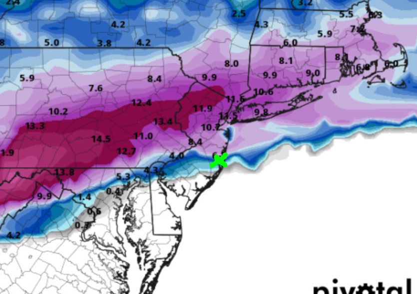
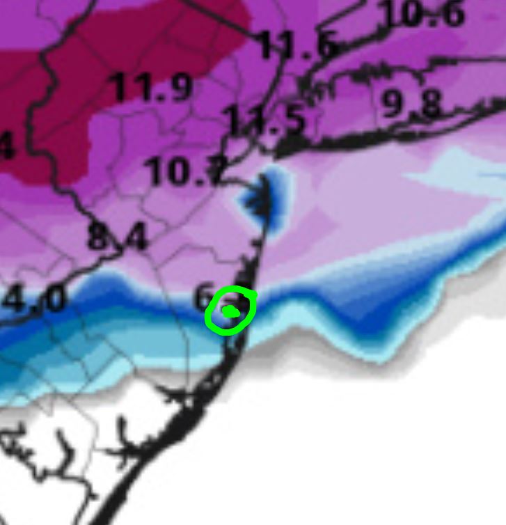
We're starting to really lock in 6"+ for that front end thump and I am ecstatic about that.
Ideally, could use another 25-50 mile SE shift and then just ride it out!
So, I'm not going to spend the next 36 hours relentlessly posting about my own particular chances for a big snow like a usually do.
Ok, that's not true at all, I just can't help myself. Rather, I'll just apologize in advance for all my impending mishegas!!! Good luck to everyone, Rooting for a SE tick in the track along with a NW expansion of the precip!!!
SENJsnowman- Senior Enthusiast

- Posts : 1189
Reputation : 61
Join date : 2017-01-06
Age : 51
Location : Bayville, NJ
 Re: Thursday, 02/18: The Next One
LOL you get me my man. We the same in some ways and I love how you have supported my weeniness when some haven't. Anyways even a push S for you I will still be happy shoot verbatim I see almost a foot I will gladly give you a push and we in my area will still sit well.SENJsnowman wrote:Hey Jman, I live about 5 miles west of the Ocean, 2 miles west of the bay and about 1 mile south of the Toms River.
We're starting to really lock in 6"+ for that front end thump and I am ecstatic about that.
Ideally, could use another 25-50 mile SE shift and then just ride it out!
So, I'm not going to spend the next 36 hours relentlessly posting about my own particular chances for a big snow like a usually do.
Ok, that's not true at all, I just can't help myself. Rather, I'll just apologize in advance for all my impending mishegas!!! Good luck to everyone, Rooting for a SE tick in the track along with a NW expansion of the precip!!!

jmanley32- Senior Enthusiast

- Posts : 20535
Reputation : 108
Join date : 2013-12-12
Age : 43
Location : Yonkers, NY
SENJsnowman likes this post
 Re: Thursday, 02/18: The Next One
sitting essentially under that 10.7
phil155- Pro Enthusiast

- Posts : 483
Reputation : 4
Join date : 2019-12-16
Page 3 of 5 •  1, 2, 3, 4, 5
Permissions in this forum:
You cannot reply to topics in this forum
 Home
Home
