
 Search
Thursday, 02/18: The Next One
Page 4 of 5 •  1, 2, 3, 4, 5
 ![]()
Re: Thursday, 02/18: The Next One
![]() by jmanley32 Tue Feb 16, 2021 6:03 pm
by jmanley32 Tue Feb 16, 2021 6:03 pm
LOL you get me my man. We the same in some ways and I love how you have supported my weeniness when some haven't. Anyways even a push S for you I will still be happy shoot verbatim I see almost a foot I will gladly give you a push and we in my area will still sit well.SENJsnowman wrote:Hey Jman, I live about 5 miles west of the Ocean, 2 miles west of the bay and about 1 mile south of the Toms River.
We're starting to really lock in 6"+ for that front end thump and I am ecstatic about that.
Ideally, could use another 25-50 mile SE shift and then just ride it out!
So, I'm not going to spend the next 36 hours relentlessly posting about my own particular chances for a big snow like a usually do.
Ok, that's not true at all, I just can't help myself. Rather, I'll just apologize in advance for all my impending mishegas!!! Good luck to everyone, Rooting for a SE tick in the track along with a NW expansion of the precip!!!


jmanley32- Senior Enthusiast

- Posts : 20535
Join date : 2013-12-13
SENJsnowman likes this post
Re: Thursday, 02/18: The Next One
![]() by phil155 Tue Feb 16, 2021 6:06 pm
by phil155 Tue Feb 16, 2021 6:06 pm
phil155- Pro Enthusiast

- Posts : 483
Join date : 2019-12-16
Re: Thursday, 02/18: The Next One
![]() by SENJsnowman Tue Feb 16, 2021 6:13 pm
by SENJsnowman Tue Feb 16, 2021 6:13 pm
phil155 wrote:sitting essentially under that 10.7
You've had some month then, huh! You might hit 4 feet yet on Thursday, no? I can't even imagine...
SENJsnowman- Senior Enthusiast
- Posts : 1189
Reputation : 61
Join date : 2017-01-06
Age : 51
Location : Bayville, NJ
Re: Thursday, 02/18: The Next One
![]() by heehaw453 Tue Feb 16, 2021 6:21 pm
by heehaw453 Tue Feb 16, 2021 6:21 pm

heehaw453- Advanced Forecaster

- Posts : 3906
Reputation : 86
Join date : 2014-01-20
Location : Bedminster Township, PA Elevation 600' ASL
Re: Thursday, 02/18: The Next One
![]() by aiannone Tue Feb 16, 2021 6:23 pm
by aiannone Tue Feb 16, 2021 6:23 pm

_________________
-Alex Iannone-

aiannone- Senior Enthusiast - Mod

- Posts : 4815
Reputation : 92
Join date : 2013-01-07
Location : Saint James, LI (Northwest Suffolk Co.)
SENJsnowman likes this post
Re: Thursday, 02/18: The Next One
![]() by frank 638 Tue Feb 16, 2021 6:26 pm
by frank 638 Tue Feb 16, 2021 6:26 pm
frank 638- Senior Enthusiast
- Posts : 2843
Reputation : 37
Join date : 2016-01-01
Age : 40
Location : bronx ny
Re: Thursday, 02/18: The Next One
![]() by billg315 Tue Feb 16, 2021 6:55 pm
by billg315 Tue Feb 16, 2021 6:55 pm

Last edited by billg315 on Tue Feb 16, 2021 6:58 pm; edited 1 time in total

billg315- Advanced Forecaster - Mod
- Posts : 4483
Reputation : 185
Join date : 2015-01-24
Age : 50
Location : Flemington, NJ
Re: Thursday, 02/18: The Next One
![]() by jmanley32 Tue Feb 16, 2021 6:57 pm
by jmanley32 Tue Feb 16, 2021 6:57 pm
Nice good 1st call, and would be happy with that. I think it has the potential to go up a bit like 8-12 potentially in the banding areas. Which looks to set up over NNJ, LI LHV and southern CT if that model holds.aiannone wrote:

jmanley32- Senior Enthusiast
- Posts : 20535
Reputation : 108
Join date : 2013-12-13
Age : 43
Location : Yonkers, NY
Re: Thursday, 02/18: The Next One
![]() by heehaw453 Tue Feb 16, 2021 7:02 pm
by heehaw453 Tue Feb 16, 2021 7:02 pm
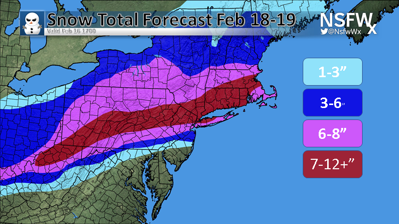
billg315 wrote:18z GFS Snow Map:
This feels like a 6-10" with localized 1' amounts who ever gets under the best banding.
heehaw453- Advanced Forecaster
- Posts : 3906
Reputation : 86
Join date : 2014-01-20
Location : Bedminster Township, PA Elevation 600' ASL
Re: Thursday, 02/18: The Next One
![]() by amugs Tue Feb 16, 2021 7:03 pm
by amugs Tue Feb 16, 2021 7:03 pm
_________________
Mugs
AKA:King: Snow Weenie
Self Proclaimed
WINTER 2014-15 : 55.12" +.02 for 6 coatings (avg. 35")
WINTER 2015-16 Total - 29.8" (Avg 35")
WINTER 2016-17 : 39.5" so far

amugs- Advanced Forecaster - Mod
- Posts : 15095
Reputation : 213
Join date : 2013-01-07
Age : 54
Location : Hillsdale,NJ
heehaw453 likes this post
Re: Thursday, 02/18: The Next One
![]() by billg315 Tue Feb 16, 2021 7:10 pm
by billg315 Tue Feb 16, 2021 7:10 pm
billg315- Advanced Forecaster - Mod
- Posts : 4483
Reputation : 185
Join date : 2015-01-24
Age : 50
Location : Flemington, NJ
heehaw453 likes this post
Re: Thursday, 02/18: The Next One
![]() by billg315 Tue Feb 16, 2021 7:11 pm
by billg315 Tue Feb 16, 2021 7:11 pm
heehaw453 wrote:billg315 wrote:18z GFS Snow Map:
This feels like a 6-10" with localized 1' amounts who ever gets under the best banding.
Yep, agree.
billg315- Advanced Forecaster - Mod
- Posts : 4483
Reputation : 185
Join date : 2015-01-24
Age : 50
Location : Flemington, NJ
Re: Thursday, 02/18: The Next One
![]() by heehaw453 Tue Feb 16, 2021 7:14 pm
by heehaw453 Tue Feb 16, 2021 7:14 pm
heehaw453- Advanced Forecaster
- Posts : 3906
Reputation : 86
Join date : 2014-01-20
Location : Bedminster Township, PA Elevation 600' ASL
SENJsnowman likes this post
Re: Thursday, 02/18: The Next One
![]() by billg315 Tue Feb 16, 2021 7:17 pm
by billg315 Tue Feb 16, 2021 7:17 pm
heehaw453 wrote:I will start watching the NAM very closely starting 0Z tonight and especially tomorrow. It sniffs out sneaky warm layers in the soundings as good as anything within 24-36 of an event. The sneaky warm layer is the caveat when you have intense WAA.
NAM did a good job with that in the 2/1 storm. I'll be keeping an eye on that too. NAM definitely shows some warm air aloft over southern and central NJ, but not before that snow has done some damage. Will definitely be in better range tomorrow morning.
billg315- Advanced Forecaster - Mod
- Posts : 4483
Reputation : 185
Join date : 2015-01-24
Age : 50
Location : Flemington, NJ
SENJsnowman likes this post
Re: Thursday, 02/18: The Next One
![]() by SENJsnowman Tue Feb 16, 2021 7:36 pm
by SENJsnowman Tue Feb 16, 2021 7:36 pm
I hope they aren’t trying to tell me something.

SENJsnowman- Senior Enthusiast
- Posts : 1189
Reputation : 61
Join date : 2017-01-06
Age : 51
Location : Bayville, NJ
Re: Thursday, 02/18: The Next One
![]() by amugs Tue Feb 16, 2021 7:44 pm
by amugs Tue Feb 16, 2021 7:44 pm
Mecs peeps is evolving.
_________________
Mugs
AKA:King: Snow Weenie
Self Proclaimed
WINTER 2014-15 : 55.12" +.02 for 6 coatings (avg. 35")
WINTER 2015-16 Total - 29.8" (Avg 35")
WINTER 2016-17 : 39.5" so far
amugs- Advanced Forecaster - Mod
- Posts : 15095
Reputation : 213
Join date : 2013-01-07
Age : 54
Location : Hillsdale,NJ
Grselig likes this post
Re: Thursday, 02/18: The Next One
![]() by amugs Tue Feb 16, 2021 7:49 pm
by amugs Tue Feb 16, 2021 7:49 pm

_________________
Mugs
AKA:King: Snow Weenie
Self Proclaimed
WINTER 2014-15 : 55.12" +.02 for 6 coatings (avg. 35")
WINTER 2015-16 Total - 29.8" (Avg 35")
WINTER 2016-17 : 39.5" so far
amugs- Advanced Forecaster - Mod
- Posts : 15095
Reputation : 213
Join date : 2013-01-07
Age : 54
Location : Hillsdale,NJ
billg315 likes this post
Re: Thursday, 02/18: The Next One
![]() by jmanley32 Tue Feb 16, 2021 7:53 pm
by jmanley32 Tue Feb 16, 2021 7:53 pm
F yeah!!!! I have been in the jackpot along with many others all this year, its amazing. After the last two years we deserve it!! This is pretty ballsy call with the + on there. Is this a trustable source?amugs wrote:Good call - Balls to the Wall
Mecs peeps is evolving.
Last edited by jmanley32 on Tue Feb 16, 2021 7:55 pm; edited 1 time in total
jmanley32- Senior Enthusiast
- Posts : 20535
Reputation : 108
Join date : 2013-12-13
Age : 43
Location : Yonkers, NY
Re: Thursday, 02/18: The Next One
![]() by amugs Tue Feb 16, 2021 7:53 pm
by amugs Tue Feb 16, 2021 7:53 pm
remember this is s cold air mass in place temps do not get above 25/26* if that* for NNJ so snow ratios will be better than 10:1 IMO more like 12:1 maybe 14:1 looking at the Chart Alex posted a week back

_________________
Mugs
AKA:King: Snow Weenie
Self Proclaimed
WINTER 2014-15 : 55.12" +.02 for 6 coatings (avg. 35")
WINTER 2015-16 Total - 29.8" (Avg 35")
WINTER 2016-17 : 39.5" so far
amugs- Advanced Forecaster - Mod
- Posts : 15095
Reputation : 213
Join date : 2013-01-07
Age : 54
Location : Hillsdale,NJ
Re: Thursday, 02/18: The Next One
![]() by jmanley32 Tue Feb 16, 2021 7:57 pm
by jmanley32 Tue Feb 16, 2021 7:57 pm
What do you think about north of NYC for rations? Not IMBY don't worry general area in NY that might see higher ratios I am asking. Its freaking cold out, we went out for a walk and the cold and wind blew in out of nowhere, was that part of the incoming cold for this storm? It was quick and the wind was fierce. I am fine with 10:1 but just curious if you think its NNJ and across horizontally.amugs wrote:GEFS are wet and improving each run
remember this is s cold air mass in place temps do not get above 25/26* if that* for NNJ so snow ratios will be better than 10:1 IMO more like 12:1 maybe 14:1 looking at the Chart Alex posted a week back
jmanley32- Senior Enthusiast
- Posts : 20535
Reputation : 108
Join date : 2013-12-13
Age : 43
Location : Yonkers, NY
Re: Thursday, 02/18: The Next One
![]() by SENJsnowman Tue Feb 16, 2021 8:02 pm
by SENJsnowman Tue Feb 16, 2021 8:02 pm
SENJsnowman- Senior Enthusiast
- Posts : 1189
Reputation : 61
Join date : 2017-01-06
Age : 51
Location : Bayville, NJ
Re: Thursday, 02/18: The Next One
![]() by aiannone Tue Feb 16, 2021 8:03 pm
by aiannone Tue Feb 16, 2021 8:03 pm
amugs wrote:GEFS are wet and improving each run
remember this is s cold air mass in place temps do not get above 25/26* if that* for NNJ so snow ratios will be better than 10:1 IMO more like 12:1 maybe 14:1 looking at the Chart Alex posted a week back
Temps at height of precip via 18z NAM, 18z GFS and 18z EURO


Ratio Chart:

_________________
-Alex Iannone-
aiannone- Senior Enthusiast - Mod
- Posts : 4815
Reputation : 92
Join date : 2013-01-07
Location : Saint James, LI (Northwest Suffolk Co.)
Re: Thursday, 02/18: The Next One
![]() by jmanley32 Tue Feb 16, 2021 8:09 pm
by jmanley32 Tue Feb 16, 2021 8:09 pm
cool yeah I seen this b4 not as clean a chart though. Wow so my temps stay in the 2nd range so up to 15 inches IF the area stays in 1.0 qpf, but looks like locally more, could this be a G? Frank is leaving HA, he isnt chiming in cuz he is crying.aiannone wrote:amugs wrote:GEFS are wet and improving each run
remember this is s cold air mass in place temps do not get above 25/26* if that* for NNJ so snow ratios will be better than 10:1 IMO more like 12:1 maybe 14:1 looking at the Chart Alex posted a week back
Temps at height of precip via 18z NAM, 18z GFS and 18z EURO
Ratio Chart:
jmanley32- Senior Enthusiast
- Posts : 20535
Reputation : 108
Join date : 2013-12-13
Age : 43
Location : Yonkers, NY
Re: Thursday, 02/18: The Next One
![]() by jmanley32 Tue Feb 16, 2021 8:16 pm
by jmanley32 Tue Feb 16, 2021 8:16 pm
jmanley32- Senior Enthusiast
- Posts : 20535
Reputation : 108
Join date : 2013-12-13
Age : 43
Location : Yonkers, NY
Re: Thursday, 02/18: The Next One
![]() by heehaw453 Tue Feb 16, 2021 8:21 pm
by heehaw453 Tue Feb 16, 2021 8:21 pm
SENJsnowman wrote:Don’t like the fact that Mt Holly ‘refuses’ to raise a wsa for Ocean County.
I hope they aren’t trying to tell me something.
The XFactor is the IP (sleet). The models are rarely going to cross section the mid-levels entirely accurate and sniff out the warm tongues. Even the NAM misses many of them. The further NW of the I-95 the less your chance of this mixing earlier than progged. Mt Holly definitely doesn't have the confidence in that right now, but that may change tomorrow. Dual-Pol radar will be in heavy use come Thursday around here, I'm sure of it and we will all be wondering when it's our turn.
heehaw453- Advanced Forecaster
- Posts : 3906
Reputation : 86
Join date : 2014-01-20
Location : Bedminster Township, PA Elevation 600' ASL
Re: Thursday, 02/18: The Next One
![]() by heehaw453 Tue Feb 16, 2021 8:24 pm
by heehaw453 Tue Feb 16, 2021 8:24 pm
jmanley32 wrote:What do you think about north of NYC for rations? Not IMBY don't worry general area in NY that might see higher ratios I am asking. Its freaking cold out, we went out for a walk and the cold and wind blew in out of nowhere, was that part of the incoming cold for this storm? It was quick and the wind was fierce. I am fine with 10:1 but just curious if you think its NNJ and across horizontally.amugs wrote:GEFS are wet and improving each run
remember this is s cold air mass in place temps do not get above 25/26* if that* for NNJ so snow ratios will be better than 10:1 IMO more like 12:1 maybe 14:1 looking at the Chart Alex posted a week back
The biggest bust potential is early mixing. Seen it too many times over the years. Models sometimes miss that warm tongue. If you can avoid mixing on this one until 90% of the QPF is exhausted you'll do very well.
heehaw453- Advanced Forecaster
- Posts : 3906
Reputation : 86
Join date : 2014-01-20
Location : Bedminster Township, PA Elevation 600' ASL
Re: Thursday, 02/18: The Next One
![]() by billg315 Tue Feb 16, 2021 8:31 pm
by billg315 Tue Feb 16, 2021 8:31 pm
billg315- Advanced Forecaster - Mod
- Posts : 4483
Reputation : 185
Join date : 2015-01-24
Age : 50
Location : Flemington, NJ
heehaw453 and Zhukov1945 like this post
Page 4 of 5 • 1, 2, 3, 4, 5 ![]()