
 Search
Long Range Discussion 22.0
Page 6 of 31 •  1 ... 5, 6, 7 ... 18 ... 31
 ![]()
Re: Long Range Discussion 22.0
![]() by amugs Tue Nov 16, 2021 10:13 am
by amugs Tue Nov 16, 2021 10:13 am

amugs- Advanced Forecaster - Mod

- Posts : 15095
Join date : 2013-01-07
phil155 likes this post
Re: Long Range Discussion 22.0
![]() by sroc4 Wed Nov 17, 2021 12:42 pm
by sroc4 Wed Nov 17, 2021 12:42 pm
Still way too much time and too many model runs to get excited, or write anything off just yet.
sroc4- Admin

- Posts : 8354
Join date : 2013-01-07
weatherwatchermom, SENJsnowman and phil155 like this post

dkodgis- Senior Enthusiast

- Posts : 2560
Reputation : 98
Join date : 2013-12-29
Re: Long Range Discussion 22.0
![]() by heehaw453 Thu Nov 18, 2021 10:54 am
by heehaw453 Thu Nov 18, 2021 10:54 am

heehaw453- Advanced Forecaster

- Posts : 3906
Reputation : 86
Join date : 2014-01-20
Location : Bedminster Township, PA Elevation 600' ASL
Re: Long Range Discussion 22.0
![]() by heehaw453 Mon Nov 22, 2021 2:45 pm
by heehaw453 Mon Nov 22, 2021 2:45 pm

heehaw453- Advanced Forecaster
- Posts : 3906
Reputation : 86
Join date : 2014-01-20
Location : Bedminster Township, PA Elevation 600' ASL
sroc4 likes this post
Re: Long Range Discussion 22.0
![]() by heehaw453 Tue Nov 23, 2021 2:05 pm
by heehaw453 Tue Nov 23, 2021 2:05 pm

heehaw453- Advanced Forecaster
- Posts : 3906
Reputation : 86
Join date : 2014-01-20
Location : Bedminster Township, PA Elevation 600' ASL
Re: Long Range Discussion 22.0
![]() by sroc4 Tue Nov 23, 2021 4:10 pm
by sroc4 Tue Nov 23, 2021 4:10 pm
algae888 wrote:Not sure what everyone else is seeing but 12 of the next 14 days look to be below normal starting with yesterday for CPK. That is the longest stretch of below normal temps in many months. Last night and today's guidance have shifted to a more colder pattern due to the pollward aleutian ridge which is now a little further East than previously modeled. Classic nina December. also the polar vortex is on our side of the globe If you believe the EPS and GEPS. Several clippers are going to pass through starting Sunday and continuing into next week any one of them could produce our first snow of the season here. I don't believe the MJO is driving the pattern right now It's basically been in the circle of death And the next wave looks to be weaker according to latest guidance Obviously things can change but I am somewhat encouraged todayalgae888 wrote:
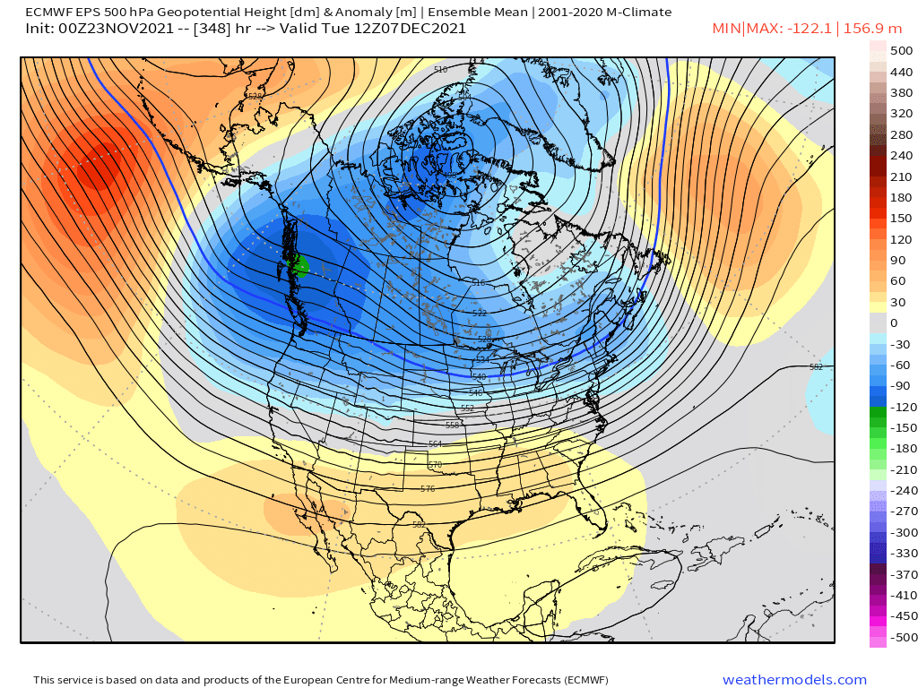
The map above was overnights 00z hr 348. Here is the same map from weather bell. There are several very important areas to look at. First notice the three areas in black circles over Canada. There are three clusters of negatives over western, central and eastern Canada. This likely represents where there are three groupings of members and where they thing the center of the trough should be. But there is a good chance that the cluster in the center are members who's solns has the trough too far west or east with regards to the two clusters in the west and the east, and in fact there wont be a trough in the cneter of Canada at this time at all. As we get closer in time these will correct. The fundamental picture would ultimately change if that happens.
Next look at the black oval circling the orange colors over the entire southern CONUS. Because of the three cluster, esp the one in the middle, the ridging in the south appears to be suppressed adding to a colder soln to the the CONUS as a whole.
And finally look at the black circle just south of the Aleutian islands. This one could end up being the most important to watch. Because if there is a ridge south of the Aleutian Islands there WILL be a trough along the WC of NA. This you can count on.

Now look at todays 12z Euro Ens below. You can already see the corrections. The center concentration of negatives(yellow circle below) are now more focused on the trough along the WC and the Trough along the EC. The result of this is now the southern ridge beginning to flex up the center (red arrow), and you still have positive heights indicating ridging conts to be most likely south of the Aleutians.

Now remember this is still 50 members avg way out in time, so all the ridge and trough features are still likely way too smooth. What most likely happens here is as the members begin to hone in on where the final soln lies the wavelengths will get more amplified and the ridge trough features get more amplified.
So with the MJO forecasted the way it is and the Strat forecast over the next 3-4weeks set up the way it is I expect the trough in the west will be real. The result will be a progressive pattern that sees energy crashing the west coast, dips into the heartland and interact with energy diving in from the polar branch strengthening it--Yellow boxes [x]. But there doesn't appear to have any resistance or help from the Pac side OR the Atlantic side to prevent it from amplifying the SE ridge out ahead, cut well to the west, raising heights along the coast which warm sectors the shy-za out of our area, then lifts north dragging a cold front in behind it. The cold air likely wont be as cold as it could be because you have Pac air masses mixing with polar air mass given the pattern.
It appears that after about this time next week we lose the -AO/-NAO blocking, and by the 3rd-4th the +PNA blocking breaks down and goes negative supporting the trough along the WC. So I will def agree that with the exception of Turkey day we will be mostly BN temp wise(hence why I wrote the scroll the way it is) and I am def not writing off solns like the 12z euro for sunday eve briunging a little snow to the region. Afterall we still do have a +PNA and a -NAO. Any time you have this timing doesnt always have to be perfect. Keep an eye on things between now and the 3rd or so. But I do believe the pattern looks poised to fundamentally shift as we head beyond the first few days of Dec. As I always say though LR forecasts are always subject to change and evolution; so what may look one way now may still may evolve differently as we get closer.
_________________
"In weather and in life, there's no winning and losing; there's only winning and learning."
WINTER 2012/2013 TOTALS 43.65"WINTER 2017/2018 TOTALS 62.85" WINTER 2022/2023 TOTALS 4.9"
WINTER 2013/2014 TOTALS 64.85"WINTER 2018/2019 TOTALS 14.25" WINTER 2023/2024 TOTALS 13.1"
WINTER 2014/2015 TOTALS 71.20"WINTER 2019/2020 TOTALS 6.35"
WINTER 2015/2016 TOTALS 35.00"WINTER 2020/2021 TOTALS 37.75"
WINTER 2016/2017 TOTALS 42.25"WINTER 2021/2022 TOTALS 31.65"

sroc4- Admin
- Posts : 8354
Reputation : 302
Join date : 2013-01-07
Location : Wading River, LI
rb924119 likes this post
Re: Long Range Discussion 22.0
![]() by rb924119 Tue Nov 23, 2021 4:53 pm
by rb924119 Tue Nov 23, 2021 4:53 pm
Nah, in all seriousness, Algae, disagreement is good! And if the ensemble played out verbatim, I’d agree with you. But in this case, I think Scott is bang-on in his above explanation about how the modeling is likely to end up correcting as we get closer to a particular forecast period. He just did a substantially better job at demonstrating it haha
rb924119- Meteorologist

- Posts : 6928
Reputation : 194
Join date : 2013-02-06
Age : 32
Location : Greentown, Pa
Re: Long Range Discussion 22.0
![]() by heehaw453 Tue Nov 23, 2021 5:40 pm
by heehaw453 Tue Nov 23, 2021 5:40 pm
heehaw453- Advanced Forecaster
- Posts : 3906
Reputation : 86
Join date : 2014-01-20
Location : Bedminster Township, PA Elevation 600' ASL
Re: Long Range Discussion 22.0
![]() by Frank_Wx Thu Nov 25, 2021 8:04 am
by Frank_Wx Thu Nov 25, 2021 8:04 am
_________________
_______________________________________________________________________________________________________
CLICK HERE to view NJ Strong Snowstorm Classifications

Frank_Wx- Godzilla Seeker
- Posts : 21305
Reputation : 328
Join date : 2013-01-05
Age : 32
Location : Jersey City, NJ -

SENJsnowman likes this post
Re: Long Range Discussion 22.0
![]() by amugs Fri Nov 26, 2021 9:39 am
by amugs Fri Nov 26, 2021 9:39 am


Last edited by amugs on Fri Nov 26, 2021 7:47 pm; edited 1 time in total
_________________
Mugs
AKA:King: Snow Weenie
Self Proclaimed
WINTER 2014-15 : 55.12" +.02 for 6 coatings (avg. 35")
WINTER 2015-16 Total - 29.8" (Avg 35")
WINTER 2016-17 : 39.5" so far

amugs- Advanced Forecaster - Mod
- Posts : 15095
Reputation : 213
Join date : 2013-01-07
Age : 54
Location : Hillsdale,NJ
Re: Long Range Discussion 22.0
![]() by heehaw453 Fri Nov 26, 2021 2:04 pm
by heehaw453 Fri Nov 26, 2021 2:04 pm
amugs wrote:Big trough over us end of next week per GEFS and EPS. Hope we can get some white golf out of this.
That's the next window of interest IMO. Some models are really throwing that upper level trough negatively tilted creating a significant storm on east coast. I'd like to see this look within 120 hours as we saw recently Thanksgiving Day storm fizzle out within 5 days lead time.
heehaw453- Advanced Forecaster
- Posts : 3906
Reputation : 86
Join date : 2014-01-20
Location : Bedminster Township, PA Elevation 600' ASL
Re: Long Range Discussion 22.0
![]() by sroc4 Fri Nov 26, 2021 2:29 pm
by sroc4 Fri Nov 26, 2021 2:29 pm
heehaw453 wrote:amugs wrote:Big trough over us end of next week per GEFS and EPS. Hope we can get some white golf out of this.
That's the next window of interest IMO. Some models are really throwing that upper level trough negatively tilted creating a significant storm on east coast. I'd like to see this look within 120 hours as we saw recently Thanksgiving Day storm fizzle out within 5 days lead time.
Have to watch and see:
A) Where does the west coast ridge axis set up
B) the trough over the WC of Canada will have energy crashing the coast. That energy will flatten down our PNA ridge, so the timing of this energy relative to any kind of shortwave rounding the trough will be crucial, and
C) If the heights are real on the EPS off the NNE/ Nova Scotia coast like that there will be a SE to SSE wind vector involved leading to surface and mid level temperature issues so placement of any developing system will be critical.
If nothing else there is at lest tracking going on. After this time frame chances will get even more challenging IMHO.
_________________
"In weather and in life, there's no winning and losing; there's only winning and learning."
WINTER 2012/2013 TOTALS 43.65"WINTER 2017/2018 TOTALS 62.85" WINTER 2022/2023 TOTALS 4.9"
WINTER 2013/2014 TOTALS 64.85"WINTER 2018/2019 TOTALS 14.25" WINTER 2023/2024 TOTALS 13.1"
WINTER 2014/2015 TOTALS 71.20"WINTER 2019/2020 TOTALS 6.35"
WINTER 2015/2016 TOTALS 35.00"WINTER 2020/2021 TOTALS 37.75"
WINTER 2016/2017 TOTALS 42.25"WINTER 2021/2022 TOTALS 31.65"
sroc4- Admin
- Posts : 8354
Reputation : 302
Join date : 2013-01-07
Location : Wading River, LI
Re: Long Range Discussion 22.0
![]() by amugs Sat Nov 27, 2021 11:33 am
by amugs Sat Nov 27, 2021 11:33 am

_________________
Mugs
AKA:King: Snow Weenie
Self Proclaimed
WINTER 2014-15 : 55.12" +.02 for 6 coatings (avg. 35")
WINTER 2015-16 Total - 29.8" (Avg 35")
WINTER 2016-17 : 39.5" so far
amugs- Advanced Forecaster - Mod
- Posts : 15095
Reputation : 213
Join date : 2013-01-07
Age : 54
Location : Hillsdale,NJ
Re: Long Range Discussion 22.0
![]() by amugs Sat Nov 27, 2021 2:26 pm
by amugs Sat Nov 27, 2021 2:26 pm

_________________
Mugs
AKA:King: Snow Weenie
Self Proclaimed
WINTER 2014-15 : 55.12" +.02 for 6 coatings (avg. 35")
WINTER 2015-16 Total - 29.8" (Avg 35")
WINTER 2016-17 : 39.5" so far
amugs- Advanced Forecaster - Mod
- Posts : 15095
Reputation : 213
Join date : 2013-01-07
Age : 54
Location : Hillsdale,NJ
Re: Long Range Discussion 22.0
![]() by rb924119 Sat Nov 27, 2021 6:28 pm
by rb924119 Sat Nov 27, 2021 6:28 pm
rb924119- Meteorologist
- Posts : 6928
Reputation : 194
Join date : 2013-02-06
Age : 32
Location : Greentown, Pa
Re: Long Range Discussion 22.0
![]() by Frank_Wx Sun Nov 28, 2021 9:18 am
by Frank_Wx Sun Nov 28, 2021 9:18 am
_________________
_______________________________________________________________________________________________________
CLICK HERE to view NJ Strong Snowstorm Classifications
Frank_Wx- Godzilla Seeker
- Posts : 21305
Reputation : 328
Join date : 2013-01-05
Age : 32
Location : Jersey City, NJ -
Re: Long Range Discussion 22.0
![]() by amugs Sun Nov 28, 2021 9:46 am
by amugs Sun Nov 28, 2021 9:46 am
rb924119 wrote:Sorry, mugsy, I just can’t get excited for anything significant these next several weeks. The image you post led is just that; a snapshot of a reflecting progressive pattern. That trough is lifting out as the ridge folds over and moves downstream. Any system caught in there will either cut or end up transferring too late for us to benefit IMO.
Rb I am just showing that there is potential for this snap shot of time around Dec 7th. We'll see what happens with tropical forcing and the response to this. I have a feeling we may have some wild swings and extremes through March.
_________________
Mugs
AKA:King: Snow Weenie
Self Proclaimed
WINTER 2014-15 : 55.12" +.02 for 6 coatings (avg. 35")
WINTER 2015-16 Total - 29.8" (Avg 35")
WINTER 2016-17 : 39.5" so far
amugs- Advanced Forecaster - Mod
- Posts : 15095
Reputation : 213
Join date : 2013-01-07
Age : 54
Location : Hillsdale,NJ


algae888- Advanced Forecaster
- Posts : 5311
Reputation : 46
Join date : 2013-02-05
Age : 62
Location : mt. vernon, new york
Re: Long Range Discussion 22.0
![]() by algae888 Sun Nov 28, 2021 10:17 am
by algae888 Sun Nov 28, 2021 10:17 am
algae888- Advanced Forecaster
- Posts : 5311
Reputation : 46
Join date : 2013-02-05
Age : 62
Location : mt. vernon, new york
Re: Long Range Discussion 22.0
![]() by aiannone Sun Nov 28, 2021 12:54 pm
by aiannone Sun Nov 28, 2021 12:54 pm
“I've been warning for weeks in the Premium Consulting Long Range discussions of major stratospheric warming was likely in the middle of December. Looks like models are starting to catch on. This should be interesting. :-) Zonal is coming, for a short time, as part of the pattern transition.”
_________________
-Alex Iannone-

aiannone- Senior Enthusiast - Mod
- Posts : 4815
Reputation : 92
Join date : 2013-01-07
Location : Saint James, LI (Northwest Suffolk Co.)
rb924119, weatherwatchermom and SENJsnowman like this post
Re: Long Range Discussion 22.0
![]() by amugs Sun Nov 28, 2021 5:28 pm
by amugs Sun Nov 28, 2021 5:28 pm
algae888 wrote:Above map is MJO phase 6 for December during negative enso. Anthony posted this in another forum. It looks like we will stay below average temperature wise but have unfavorable storm tracks for the 1st week of December After that however we will see what happens with this MJO pulse does it move out of phase 6 and head toward the cold phases or does it die there we shall see
Lets hope this is correct as swing
 through 6 and head into much more favorable 7 then phase 8
_________________
Mugs
AKA:King: Snow Weenie
Self Proclaimed
WINTER 2014-15 : 55.12" +.02 for 6 coatings (avg. 35")
WINTER 2015-16 Total - 29.8" (Avg 35")
WINTER 2016-17 : 39.5" so far
amugs- Advanced Forecaster - Mod
- Posts : 15095
Reputation : 213
Join date : 2013-01-07
Age : 54
Location : Hillsdale,NJ
Re: Long Range Discussion 22.0
![]() by rb924119 Sun Nov 28, 2021 6:19 pm
by rb924119 Sun Nov 28, 2021 6:19 pm
aiannone wrote:From Steve D:
“I've been warning for weeks in the Premium Consulting Long Range discussions of major stratospheric warming was likely in the middle of December. Looks like models are starting to catch on. This should be interesting. :-) Zonal is coming, for a short time, as part of the pattern transition.”
He’s a couple weeks faster than me, approximately, with the start of the Stratospheric warming, but I fully agree with the overall premise. Though I’d like to see the models that he’s referencing here, because nothing that I’ve seen has supported this idea with any consistency, aside from a few GFS Operational runs (which we all know how to handle beyond Day…..2 lmaoooo)
rb924119- Meteorologist
- Posts : 6928
Reputation : 194
Join date : 2013-02-06
Age : 32
Location : Greentown, Pa
Re: Long Range Discussion 22.0
![]() by rb924119 Sun Nov 28, 2021 6:23 pm
by rb924119 Sun Nov 28, 2021 6:23 pm
amugs wrote:algae888 wrote:Above map is MJO phase 6 for December during negative enso. Anthony posted this in another forum. It looks like we will stay below average temperature wise but have unfavorable storm tracks for the 1st week of December After that however we will see what happens with this MJO pulse does it move out of phase 6 and head toward the cold phases or does it die there we shall see
Lets hope this is correct as swing
I wouldn’t hold my breath, mugsy. Exceptionally strong standing wave over the Maritime Continent being enhanced by the La Niña will kill this. But as I said, I want to see this wave constructively interfere in Phase 6 and into 7 as much as possible before being shredded, because this WILL destructively interfere with the Stratospheric PV and constructively interfere with the downwelling easterly QBO. The longer and stronger in Phase 6/7 now, the greater the potential reward later, IMO.
rb924119- Meteorologist
- Posts : 6928
Reputation : 194
Join date : 2013-02-06
Age : 32
Location : Greentown, Pa
amugs and SENJsnowman like this post
Re: Long Range Discussion 22.0
![]() by amugs Mon Nov 29, 2021 8:43 am
by amugs Mon Nov 29, 2021 8:43 am
ok..here's our next system potential to follow...still a bit out... just keep an eye on the ensembles until we're around 4-5 days
— NsfwWx
but a pretty robust wave passing through with inversion... euro a bit late on the trough tilt, heavier snows inland... GFS is a bit faster to coast pic.twitter.com/LM5ijgjmke(@NsfwWx) November 29, 2021
We shall see but interesting how it was cutter city two days ago and last night 18Z runs it started to shift these SE on BOTH ENS and OP runs. Only 6 days away LOL!
Up close views:
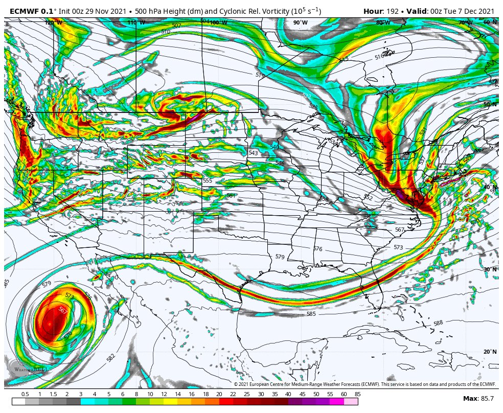

Smoke City for LI! IF IT VERIFIES!!

_________________
Mugs
AKA:King: Snow Weenie
Self Proclaimed
WINTER 2014-15 : 55.12" +.02 for 6 coatings (avg. 35")
WINTER 2015-16 Total - 29.8" (Avg 35")
WINTER 2016-17 : 39.5" so far
amugs- Advanced Forecaster - Mod
- Posts : 15095
Reputation : 213
Join date : 2013-01-07
Age : 54
Location : Hillsdale,NJ
rb924119 likes this post
Re: Long Range Discussion 22.0
![]() by heehaw453 Mon Nov 29, 2021 9:34 am
by heehaw453 Mon Nov 29, 2021 9:34 am
heehaw453- Advanced Forecaster
- Posts : 3906
Reputation : 86
Join date : 2014-01-20
Location : Bedminster Township, PA Elevation 600' ASL
sroc4 and rb924119 like this post
Re: Long Range Discussion 22.0
![]() by MattyICE Mon Nov 29, 2021 11:46 am
by MattyICE Mon Nov 29, 2021 11:46 am
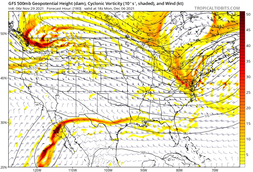
This image highlights just a snapshot, but the context surrounding it ends up being very similar to what I think will be the true evolution. While there is moderate HP north of main, it scoots away to the east as the LP approaches. No 50/50 LP to block that HP in place to supply cold air…no Greenland Block/-NAO to hold a 50/50 in even if there was one. So even if we do get Pacific “help” in the form of a relaxed EPO or a temporary PNA ridge “spike”, most of that gets mitigated on today’s 12z operational GFS. Still fun to track, and obviously things can change - all caveats apply - but I agree with those who have viewed this threat period with skepticism.
MattyICE- Advanced Forecaster
- Posts : 249
Reputation : 6
Join date : 2017-11-10
Age : 38
Location : Clifton, NJ (Eastern Passaic County)
sroc4 and rb924119 like this post
Page 6 of 31 • 1 ... 5, 6, 7 ... 18 ... 31 ![]()
|
|
|