
 Search
Long Range Discussion 22.0
Page 16 of 31 •  1 ... 9 ... 15, 16, 17 ... 23 ... 31
 ![]()
Re: Long Range Discussion 22.0
![]() by rb924119 Sun Dec 26, 2021 2:22 pm
by rb924119 Sun Dec 26, 2021 2:22 pm
dkodgis wrote:And…we watch paint dry
We’re facing the Guns of warmth now, Damian, but we’ll get the sweet smell of Roses later - “all we need is just a little patience”.
Not gonna lie, I thought that was pretty clever lmao
Remember, Week 2 into Week 3 of January has always been my target period for the flip before we should largely run the rest of the table with Winter. Again, it’s only my opinion, but so far, the cards that I was expecting to be played have been, so I see no reason to abandon what’s gotten me to this point.
rb924119- Meteorologist

- Posts : 6889
Join date : 2013-02-06
Re: Long Range Discussion 22.0
![]() by Wheezer Sun Dec 26, 2021 2:27 pm
by Wheezer Sun Dec 26, 2021 2:27 pm
rb924119 wrote:Wheezer wrote:It just seems like we've been poo-pooing this LaNina event far to long as record warmth has inundated the lower 48 all winter. And now we see a +80 point rise in SOI in just over just a few days, which tells me , atm , that LaNina is well in control still.
Who’s been disregarding the La Niña? If anything, I feel like we have collectively been acknowledging the fact that it has, and continues to drive the pattern.
Refering more to those that had predicted back in November a fast and early .start to winter
Wheezer- Posts : 30
Join date : 2017-11-08
CPcantmeasuresnow and rb924119 like this post
Re: Long Range Discussion 22.0
![]() by dkodgis Sun Dec 26, 2021 3:10 pm
by dkodgis Sun Dec 26, 2021 3:10 pm

dkodgis- Senior Enthusiast

- Posts : 2495
Reputation : 98
Join date : 2013-12-29
rb924119 likes this post
Re: Long Range Discussion 22.0
![]() by Frank_Wx Sun Dec 26, 2021 3:40 pm
by Frank_Wx Sun Dec 26, 2021 3:40 pm
_________________
_______________________________________________________________________________________________________
CLICK HERE to view NJ Strong Snowstorm Classifications

Frank_Wx- Godzilla Seeker

- Posts : 21305
Reputation : 328
Join date : 2013-01-05
Age : 31
Location : Jersey City, NJ -

rb924119 and MattyICE like this post
Re: Long Range Discussion 22.0
![]() by amugs Sun Dec 26, 2021 4:29 pm
by amugs Sun Dec 26, 2021 4:29 pm
Wheeler a few calls for this due to typical Nina's are a fast start to winter and there where indicators and analogs showing such. We learn with each season, pattern and storm in the hobby, & profession.
_________________
Mugs
AKA:King: Snow Weenie
Self Proclaimed
WINTER 2014-15 : 55.12" +.02 for 6 coatings (avg. 35")
WINTER 2015-16 Total - 29.8" (Avg 35")
WINTER 2016-17 : 39.5" so far

amugs- Advanced Forecaster - Mod

- Posts : 15093
Reputation : 213
Join date : 2013-01-07
Age : 54
Location : Hillsdale,NJ
rb924119 likes this post
Re: Long Range Discussion 22.0
![]() by Frank_Wx Sun Dec 26, 2021 10:31 pm
by Frank_Wx Sun Dec 26, 2021 10:31 pm
amugs wrote:The gradient pattern is difficult for the models and Ens to figure out 7 days let alone 4 days out. But the NAO looks to be holding on which will help at times as long as the trough over the WC is not on roids. If the trough gets pumped then things will be to far west for us and become purely inland runners. BUT I like where the gradient t is for now being modeled. Transitions is the pattern.
Wheeler a few calls for this due to typical Nina's are a fast start to winter and there where indicators and analogs showing such. We learn with each season, pattern and storm in the hobby, & profession.
SWFEs often produce a narrow jackpot zone that usually sit just north of the baroclinic zone. There may be just enough blocking to prevent the inland runners / cutters but I’m not feeling hopeful just yet.
_________________
_______________________________________________________________________________________________________
CLICK HERE to view NJ Strong Snowstorm Classifications
Frank_Wx- Godzilla Seeker
- Posts : 21305
Reputation : 328
Join date : 2013-01-05
Age : 31
Location : Jersey City, NJ -
phil155 likes this post
Re: Long Range Discussion 22.0
![]() by rb924119 Mon Dec 27, 2021 2:08 am
by rb924119 Mon Dec 27, 2021 2:08 am
rb924119- Meteorologist
- Posts : 6889
Reputation : 194
Join date : 2013-02-06
Age : 32
Location : Greentown, Pa
Sparky Sparticles likes this post

Snow88- Senior Enthusiast
- Posts : 2193
Reputation : 4
Join date : 2013-01-09
Age : 35
Location : Brooklyn, NY
Re: Long Range Discussion 22.0
![]() by billg315 Mon Dec 27, 2021 10:50 am
by billg315 Mon Dec 27, 2021 10:50 am
rb924119 wrote:Maybe this belongs in Banter, but the EURO Op at Days 11-12 would probably be a HECS if extrapolated verbatim lol just figured I’d post it so we can all dream in unison and maybe make it a reality haha
Hope springs eternal. At least the expected temperature regime in that time-frame is snow friendly.

billg315- Advanced Forecaster - Mod
- Posts : 4462
Reputation : 185
Join date : 2015-01-24
Age : 50
Location : Flemington, NJ
rb924119 likes this post
Re: Long Range Discussion 22.0
![]() by heehaw453 Mon Dec 27, 2021 11:42 am
by heehaw453 Mon Dec 27, 2021 11:42 am
heehaw453- Advanced Forecaster

- Posts : 3906
Reputation : 86
Join date : 2014-01-20
Location : Bedminster Township, PA Elevation 600' ASL
rb924119 likes this post
dkodgis- Senior Enthusiast
- Posts : 2495
Reputation : 98
Join date : 2013-12-29
Re: Long Range Discussion 22.0
![]() by amugs Mon Dec 27, 2021 1:37 pm
by amugs Mon Dec 27, 2021 1:37 pm
_________________
Mugs
AKA:King: Snow Weenie
Self Proclaimed
WINTER 2014-15 : 55.12" +.02 for 6 coatings (avg. 35")
WINTER 2015-16 Total - 29.8" (Avg 35")
WINTER 2016-17 : 39.5" so far
amugs- Advanced Forecaster - Mod
- Posts : 15093
Reputation : 213
Join date : 2013-01-07
Age : 54
Location : Hillsdale,NJ
rb924119 likes this post
Re: Long Range Discussion 22.0
![]() by amugs Mon Dec 27, 2021 1:38 pm
by amugs Mon Dec 27, 2021 1:38 pm

_________________
Mugs
AKA:King: Snow Weenie
Self Proclaimed
WINTER 2014-15 : 55.12" +.02 for 6 coatings (avg. 35")
WINTER 2015-16 Total - 29.8" (Avg 35")
WINTER 2016-17 : 39.5" so far
amugs- Advanced Forecaster - Mod
- Posts : 15093
Reputation : 213
Join date : 2013-01-07
Age : 54
Location : Hillsdale,NJ
rb924119 likes this post
Re: Long Range Discussion 22.0
![]() by heehaw453 Mon Dec 27, 2021 1:48 pm
by heehaw453 Mon Dec 27, 2021 1:48 pm

heehaw453- Advanced Forecaster
- Posts : 3906
Reputation : 86
Join date : 2014-01-20
Location : Bedminster Township, PA Elevation 600' ASL
rb924119 and phil155 like this post
Re: Long Range Discussion 22.0
![]() by amugs Mon Dec 27, 2021 2:01 pm
by amugs Mon Dec 27, 2021 2:01 pm
From 33 n Rain wx bd

_________________
Mugs
AKA:King: Snow Weenie
Self Proclaimed
WINTER 2014-15 : 55.12" +.02 for 6 coatings (avg. 35")
WINTER 2015-16 Total - 29.8" (Avg 35")
WINTER 2016-17 : 39.5" so far
amugs- Advanced Forecaster - Mod
- Posts : 15093
Reputation : 213
Join date : 2013-01-07
Age : 54
Location : Hillsdale,NJ
phil155 likes this post
Re: Long Range Discussion 22.0
![]() by amugs Mon Dec 27, 2021 2:03 pm
by amugs Mon Dec 27, 2021 2:03 pm
_________________
Mugs
AKA:King: Snow Weenie
Self Proclaimed
WINTER 2014-15 : 55.12" +.02 for 6 coatings (avg. 35")
WINTER 2015-16 Total - 29.8" (Avg 35")
WINTER 2016-17 : 39.5" so far
amugs- Advanced Forecaster - Mod
- Posts : 15093
Reputation : 213
Join date : 2013-01-07
Age : 54
Location : Hillsdale,NJ
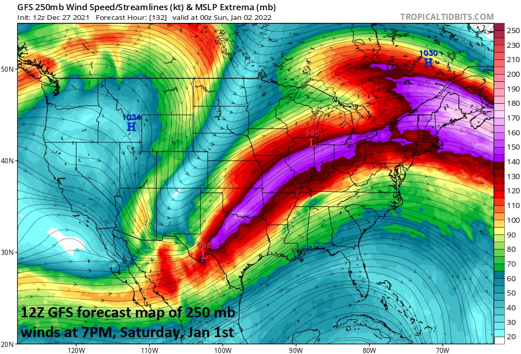
Re: Long Range Discussion 22.0
![]() by heehaw453 Mon Dec 27, 2021 2:23 pm
by heehaw453 Mon Dec 27, 2021 2:23 pm
amugs wrote:Nice jet streak
There is a window there Mugs, but we have bad wave spacing as modelled. Extremely complex for this to work out as the low has room to go east based on the WAR position. The other thing is the antecedent air mass would be bad. Of course this implies this Euro run has it right one week out which we know it doesn't. Definitely worth watching though.

heehaw453- Advanced Forecaster
- Posts : 3906
Reputation : 86
Join date : 2014-01-20
Location : Bedminster Township, PA Elevation 600' ASL
amugs likes this post
Re: Long Range Discussion 22.0
![]() by amugs Mon Dec 27, 2021 7:27 pm
by amugs Mon Dec 27, 2021 7:27 pm
Legitimate Eastern US storm chances are appearing in the 5-7 day timeframe, thanks to the temporary collapse of the Pacific Ridge. This collapse makes the overall pattern more progressive, allowing troughs to make it into the previously walled-off Eastern US. pic.twitter.com/TYQwsNlAtp
— Nikhil Trivedi (@DCAreaWx) December 27, 2021
_________________
Mugs
AKA:King: Snow Weenie
Self Proclaimed
WINTER 2014-15 : 55.12" +.02 for 6 coatings (avg. 35")
WINTER 2015-16 Total - 29.8" (Avg 35")
WINTER 2016-17 : 39.5" so far
amugs- Advanced Forecaster - Mod
- Posts : 15093
Reputation : 213
Join date : 2013-01-07
Age : 54
Location : Hillsdale,NJ
Re: Long Range Discussion 22.0
![]() by heehaw453 Tue Dec 28, 2021 10:07 am
by heehaw453 Tue Dec 28, 2021 10:07 am
Need to see this look within 5 days.
Some pictures to show differences of the mess we are in and where models are hinting of going. Note the positive tilt of the PAC trough in the Now picture and this is what IMO is causing that SE ridge to pump. Even deep trough can be go not so bad if it was neutral.
Future

Now

heehaw453- Advanced Forecaster
- Posts : 3906
Reputation : 86
Join date : 2014-01-20
Location : Bedminster Township, PA Elevation 600' ASL
Re: Long Range Discussion 22.0
![]() by heehaw453 Tue Dec 28, 2021 11:25 am
by heehaw453 Tue Dec 28, 2021 11:25 am

heehaw453- Advanced Forecaster
- Posts : 3906
Reputation : 86
Join date : 2014-01-20
Location : Bedminster Township, PA Elevation 600' ASL
Re: Long Range Discussion 22.0
![]() by sroc4 Tue Dec 28, 2021 12:24 pm
by sroc4 Tue Dec 28, 2021 12:24 pm
heehaw453 wrote:Of course I'm not letting the GFS suck me into this at day 5+, but that is a nice h5 look for decent snow. If that is true, then coastal areas have a shot at something around 1/2-3. Will the GFS show this in 2 days, lol?
As long as we cont to maintain those positive heights in the west there is a chance. Like you said still too far out to take serious though. CMC much flatter out west with 12z resulting in the progressive flow and nothing. Must must must maintain some sort of ridging in the west. As we have said in the past baby bear needed.
GFS vs CMC:


_________________
"In weather and in life, there's no winning and losing; there's only winning and learning."
WINTER 2012/2013 TOTALS 43.65"WINTER 2017/2018 TOTALS 62.85" WINTER 2022/2023 TOTALS 4.9"
WINTER 2013/2014 TOTALS 64.85"WINTER 2018/2019 TOTALS 14.25" WINTER 2023/2024 TOTALS 13.1"
WINTER 2014/2015 TOTALS 71.20"WINTER 2019/2020 TOTALS 6.35"
WINTER 2015/2016 TOTALS 35.00"WINTER 2020/2021 TOTALS 37.75"
WINTER 2016/2017 TOTALS 42.25"WINTER 2021/2022 TOTALS 31.65"

sroc4- Admin
- Posts : 8331
Reputation : 301
Join date : 2013-01-07
Location : Wading River, LI
heehaw453 likes this post
Re: Long Range Discussion 22.0
![]() by rb924119 Tue Dec 28, 2021 12:34 pm
by rb924119 Tue Dec 28, 2021 12:34 pm
heehaw453 wrote:There is some indication of a more serviceable PAC as we get passed January 7. This would allow for much better storm potential and the colder air to bleed eastward. I would take this with a grain of salt for now as the PAC trough could easily hang tough and pump the SE ridge and push things back even further.
Need to see this look within 5 days.
Some pictures to show differences of the mess we are in and where models are hinting of going. Note the positive tilt of the PAC trough in the Now picture and this is what IMO is causing that SE ridge to pump. Even deep trough can be go not so bad if it was neutral.
Future
Now
Right on track
rb924119- Meteorologist
- Posts : 6889
Reputation : 194
Join date : 2013-02-06
Age : 32
Location : Greentown, Pa
heehaw453 likes this post
Re: Long Range Discussion 22.0
![]() by SENJsnowman Tue Dec 28, 2021 12:47 pm
by SENJsnowman Tue Dec 28, 2021 12:47 pm
SENJsnowman- Senior Enthusiast
- Posts : 1186
Reputation : 61
Join date : 2017-01-06
Age : 51
Location : Bayville, NJ
Re: Long Range Discussion 22.0
![]() by heehaw453 Tue Dec 28, 2021 1:44 pm
by heehaw453 Tue Dec 28, 2021 1:44 pm

heehaw453- Advanced Forecaster
- Posts : 3906
Reputation : 86
Join date : 2014-01-20
Location : Bedminster Township, PA Elevation 600' ASL
Re: Long Range Discussion 22.0
![]() by rb924119 Tue Dec 28, 2021 1:45 pm
by rb924119 Tue Dec 28, 2021 1:45 pm
SENJsnowman wrote:Rb, are the horrific temps and pattern coming up for this week a direct manifestation of “the worse it gets sooner, the better it will be later” that you have been alluding to?
Not just the next week or so, but the whole month of December as well haha it’s a process that takes time evolve, and we are nearing the point in that evolution where it’s darkest just before dawn. At least in my opinion.
rb924119- Meteorologist
- Posts : 6889
Reputation : 194
Join date : 2013-02-06
Age : 32
Location : Greentown, Pa
SENJsnowman, MattyICE, phil155 and Bwtr like this post
Re: Long Range Discussion 22.0
![]() by heehaw453 Tue Dec 28, 2021 1:55 pm
by heehaw453 Tue Dec 28, 2021 1:55 pm
rb924119 wrote:SENJsnowman wrote:Rb, are the horrific temps and pattern coming up for this week a direct manifestation of “the worse it gets sooner, the better it will be later” that you have been alluding to?
Not just the next week or so, but the whole month of December as well haha it’s a process that takes time evolve, and we are nearing the point in that evolution where it’s darkest just before dawn. At least in my opinion.
So far RB it does look like your forecast is coming into better view we approach January. Also there are some hints of PV lobe displacement coming from Hudson Bay that could enhance the colder temps. All I can say is I want to believe, I really do, but I just need to see things materialize further to have much confidence.
heehaw453- Advanced Forecaster
- Posts : 3906
Reputation : 86
Join date : 2014-01-20
Location : Bedminster Township, PA Elevation 600' ASL
sroc4, rb924119, SENJsnowman and phil155 like this post
Re: Long Range Discussion 22.0
![]() by sroc4 Tue Dec 28, 2021 5:39 pm
by sroc4 Tue Dec 28, 2021 5:39 pm
heehaw453 wrote:The 12Z Euro western heights are pumped tantamount with GFS. The issue is you don't have much s/w energy rounding the base of the trough and it's a bit of a positive tilt. If this was to amount to anything I'd like to see more neutral tilt and some s/w energy rounding the base. However, any s/w energy sampling won't be for a few days, and the tilt could definitely be adjusted at this range. I'd just say low probability window right now.
The real difference between the two is the timing and positioning of the energy early on. Look at the difference between the side by sides with Euro on the left and GFS on the right by hr 90. Euro already phasing alot of energy where as GFS is not.

Its messy with all that phasing energy as it exits into the Plains and heads into the east but by hr 126 on the Euro, which coincides with the image you posted above, it results in one long strong strung out progressive line of vorticity and a seperate thinner line of vort well out ahead of it just off the E coast ; hence the very positive tilt you mention whereas the GFS is weaker with the trailing line of vorticity and taking its time but catching up with the second leading line of vorticity.

Notice the difference between the gap between the two lines I drew outlining the two areas of SW to NE oriented vorticity on both models on both hr 126 and the last image which is hr 138. The euro keeps both lines or vort separate hence the warmer run and no storm forming south of us. The GFS however catches up with that energy and you get a phase, and hence a storm develop to the south and a colder soln. The phase is just a few hours too late so you still have a pos tilt,(albiet much less pos/closer to neutral tilt) relative to the euro soln, and the system scrapes the area.


Overall if you look at the western trough in the side by side comparisons they look pretty damn similar which is good news. There is SO much energy coming into the west coast of NA and diving in from Alaska etc that I think its still at least 2 days before we start to see some consistency with how models from run to run depict all the energy. Heck look at the energy difference even at hr 75 on the side by side:

_________________
"In weather and in life, there's no winning and losing; there's only winning and learning."
WINTER 2012/2013 TOTALS 43.65"WINTER 2017/2018 TOTALS 62.85" WINTER 2022/2023 TOTALS 4.9"
WINTER 2013/2014 TOTALS 64.85"WINTER 2018/2019 TOTALS 14.25" WINTER 2023/2024 TOTALS 13.1"
WINTER 2014/2015 TOTALS 71.20"WINTER 2019/2020 TOTALS 6.35"
WINTER 2015/2016 TOTALS 35.00"WINTER 2020/2021 TOTALS 37.75"
WINTER 2016/2017 TOTALS 42.25"WINTER 2021/2022 TOTALS 31.65"
sroc4- Admin
- Posts : 8331
Reputation : 301
Join date : 2013-01-07
Location : Wading River, LI
heehaw453, Wheezer and phil155 like this post
Page 16 of 31 • 1 ... 9 ... 15, 16, 17 ... 23 ... 31 ![]()
|
|
|