Long Range Discussion 22.0
+33
skinsfan1177
chief7
WeatherBob
emokid51783
hyde345
jmanley32
dsix85
jaydoy
billg315
lglickman1
CPcantmeasuresnow
Snow88
mmanisca
phil155
weatherwatchermom
Dunnzoo
nutleyblizzard
Radz
Irish
Wheezer
Math23x7
rb924119
SENJsnowman
heehaw453
algae888
aiannone
MattyICE
frank 638
Frank_Wx
docstox12
dkodgis
amugs
sroc4
37 posters
Page 24 of 31
Page 24 of 31 •  1 ... 13 ... 23, 24, 25 ... 27 ... 31
 Re: Long Range Discussion 22.0
Upton takerb924119 wrote:We can’t sleep on the 13th either, although I think that will likely just miss to our east.
"In wake of polar trough, northern stream upper flow will dominate
mid to late week with E US trough amplifying in response to a series
of shortwaves moving through the flow. The shortwave energy of note
appears to be NE PAC origin, diving towards the SE US coast for
midweek. General agreement with this energy being the catalyst for
northern and southern stream phasing Thu/Fri with development of
[url=https://forecast.weather.gov/glossary.php?word=closed low]closed low[/url] upper low and strong low pressure off the SE US coast. At
this time, model consensus is that that this phasing will take place
too far east in a progressive flow, keeping developing low pressure
well east of the region. Since this is still 5-6 days out, with
these interactions inherently tough for models to resolve, something
that bears watching through the week for development and track
closer to the coast. Otherwise, locally just a weak and dry frontal
passage on Thursday in response to digging and eastward translating
northern stream trough.
algae888- Advanced Forecaster

- Posts : 5311
Join date : 2013-02-05
 Re: Long Range Discussion 22.0
rb924119 wrote:We can’t sleep on the 13th either, although I think that will likely just miss to our east.
Let me know as soon as you get a feel on this, my Mom is supposed to fly out to Florida Thursday at 2 pm, I may change her flight to the 12th.
Dunnzoo- Senior Enthusiast - Mod

- Posts : 4892
Join date : 2013-01-11
 Re: Long Range Discussion 22.0
Snow88 wrote:Someone post the gfs for next weekend lol
I feel like we should have a Clown Maps thread lol. Although I guess sometimes they're posted in the banter thread when it's too far in the future. Would be fun to see a collective of all the huge outputs historically and for those that don't get too superstitious - see what's being forecast in the long term.

crippo84- Posts : 383
Reputation : 20
Join date : 2013-11-07
Age : 40
Location : East Village, NYC
 Re: Long Range Discussion 22.0
_________________
Mugs
AKA:King: Snow Weenie
Self Proclaimed
WINTER 2014-15 : 55.12" +.02 for 6 coatings (avg. 35")
WINTER 2015-16 Total - 29.8" (Avg 35")
WINTER 2016-17 : 39.5" so far

amugs- Advanced Forecaster - Mod

- Posts : 15093
Reputation : 213
Join date : 2013-01-07
Age : 54
Location : Hillsdale,NJ
 Re: Long Range Discussion 22.0
Rb would you look at this forecast !!


_________________
Mugs
AKA:King: Snow Weenie
Self Proclaimed
WINTER 2014-15 : 55.12" +.02 for 6 coatings (avg. 35")
WINTER 2015-16 Total - 29.8" (Avg 35")
WINTER 2016-17 : 39.5" so far

amugs- Advanced Forecaster - Mod

- Posts : 15093
Reputation : 213
Join date : 2013-01-07
Age : 54
Location : Hillsdale,NJ
 Re: Long Range Discussion 22.0
Hereeeeee she comessssssssssssss. GEM and EURO seeing the light for the 16th? I think we’re headed in the right direction!
rb924119- Meteorologist

- Posts : 6890
Reputation : 194
Join date : 2013-02-06
Age : 32
Location : Greentown, Pa
 Re: Long Range Discussion 22.0
The EURO just NAM’d us for the 16th.
rb924119- Meteorologist

- Posts : 6890
Reputation : 194
Join date : 2013-02-06
Age : 32
Location : Greentown, Pa
 Re: Long Range Discussion 22.0
amugs wrote:Rb would you look at this forecast !!
That’s not a favorable look for us verbatim. But it’s a 600+ he control run. I’m not worried lol the ensemble looks much better, for whatever it may be worth - still assessing the value of this model.
rb924119- Meteorologist

- Posts : 6890
Reputation : 194
Join date : 2013-02-06
Age : 32
Location : Greentown, Pa
 Re: Long Range Discussion 22.0
Tonight’s EURO looks like today’s EURO Control through ten days. This is wild.
rb924119- Meteorologist

- Posts : 6890
Reputation : 194
Join date : 2013-02-06
Age : 32
Location : Greentown, Pa
weatherwatchermom and Bwtr like this post
 Re: Long Range Discussion 22.0
To be intellectually honest, technically, it didn’t NAM us verbatim. Our northern posters of the Hudson Valley and NEPA got NAM’d. BUT, the changes aloft are exactly what I’m looking for and am beginning to expect the more I analyze this. I’ll probably post a video tomorrow explaining these ideas. It’s a very complicated evolution, and I need to look at everything with a clear mind lol one of the hardest events I’ve looked at in quite some time. Gonna sleep on it and get back to it in the morning. Good night folks. Dunnz, I’ll also touch on the 13th threat that I and algae brought up earlier, but as I said, I think that will miss to our east.
rb924119- Meteorologist

- Posts : 6890
Reputation : 194
Join date : 2013-02-06
Age : 32
Location : Greentown, Pa
Dunnzoo likes this post
 Re: Long Range Discussion 22.0
Guidance is not in consensus w.r.t. which s/w energy to focus on. Euro/Canadian are bullish on 1/16, but not GFS. I don't think we'll have much clarity on this until Tuesday night/Wed overall. Some of the operational models like Euro/Canadian want to hang onto the primary low a bit too long for central and southern half of the forum and this turn into rain there. But their ensembles are not that way and provide a faster and cleaner transfer of energy to a coastal. That's always complex, but what seems clear is the progressive nature of storm movement will be much less so there is potential for a larger scale event. But as usual at this range it depends and the devil is in the details.
heehaw453- Advanced Forecaster

- Posts : 3906
Reputation : 86
Join date : 2014-01-20
Location : Bedminster Township, PA Elevation 600' ASL
SENJsnowman likes this post
 Re: Long Range Discussion 22.0
Yeah heehaw, I noticed looking at the long range, the temps seem to be on the high side and rain sneaking in.

Irish- Pro Enthusiast

- Posts : 788
Reputation : 19
Join date : 2019-01-16
Age : 45
Location : Old Bridge, NJ
 Re: Long Range Discussion 22.0
I look at this like a baseball game where the pitcher (who represents the overall weather pattern in this analogy) starts giving up long fly balls left and right. Some may go just outside the foul pole or get caught on the track against the wall, but as long as they don’t pull that pitcher, you know it’s only a matter of time before a couple clear the fences for home runs.

billg315- Advanced Forecaster - Mod

- Posts : 4469
Reputation : 185
Join date : 2015-01-24
Age : 50
Location : Flemington, NJ
 Re: Long Range Discussion 22.0
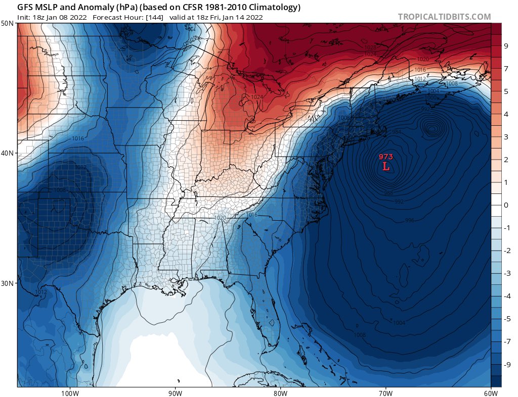
Wow on the system in atlantic this week 955mb? It also looks like the size of Sandy, Any chance we putt this far enough west to get a MECS or even better? It clips maine atm. I wish you guys would post those Euro snow maps lol, I agree a clown map thread lol

jmanley32- Senior Enthusiast

- Posts : 20517
Reputation : 108
Join date : 2013-12-12
Age : 42
Location : Yonkers, NY
 Re: Long Range Discussion 22.0
billg315 wrote:I look at this like a baseball game where the pitcher (who represents the overall weather pattern in this analogy) starts giving up long fly balls left and right. Some may go just outside the foul pole or get caught on the track against the wall, but as long as they don’t pull that pitcher, you know it’s only a matter of time before a couple clear the fences for home runs.
You are probably right Billg. As the SOI values continue to fall we open up the sub tropical jet for moisture and energy and generate split flows with arctic air on the northern side. That is indicative of el nino type patterns which we are not in, but yet here we are. We saw recently major snowfall for our coastal areas in a pattern that really had no business producing that kind of system. It was just perfectly timed window. Things still come down to timing at the end of the day...
As these values fall I would expect a much more active pattern in general.

heehaw453- Advanced Forecaster

- Posts : 3906
Reputation : 86
Join date : 2014-01-20
Location : Bedminster Township, PA Elevation 600' ASL
 Re: Long Range Discussion 22.0
Here are the potential storms as outlined by ShowMeSnow from another bd. Models like Fridays storm are going to have a hard time like in 13-14, 14-15 with some much energy flying around North America.


_________________
Mugs
AKA:King: Snow Weenie
Self Proclaimed
WINTER 2014-15 : 55.12" +.02 for 6 coatings (avg. 35")
WINTER 2015-16 Total - 29.8" (Avg 35")
WINTER 2016-17 : 39.5" so far

amugs- Advanced Forecaster - Mod

- Posts : 15093
Reputation : 213
Join date : 2013-01-07
Age : 54
Location : Hillsdale,NJ
 Re: Long Range Discussion 22.0
Like Al mentioned there are several waves of upper energy to watch by the time we get to next weekend. It’s possible the energy off the SE coast, which is the storm around the 14th, disrupts the flow downstream and prevents the storm on the 16th-17th from coming together. That said, look at how many pieces of energy models are having to focus on. We’re going to see drastic changes run to run. We’ll need to wait until Wednesday to really have a better idea of what’s going on with all of these. My guess is, the waves between 15th-17th don’t materialize for us, but we’ll have a better pattern from the 19th onward.


_________________
_______________________________________________________________________________________________________
CLICK HERE to view NJ Strong Snowstorm Classifications
rb924119 likes this post
 Re: Long Range Discussion 22.0
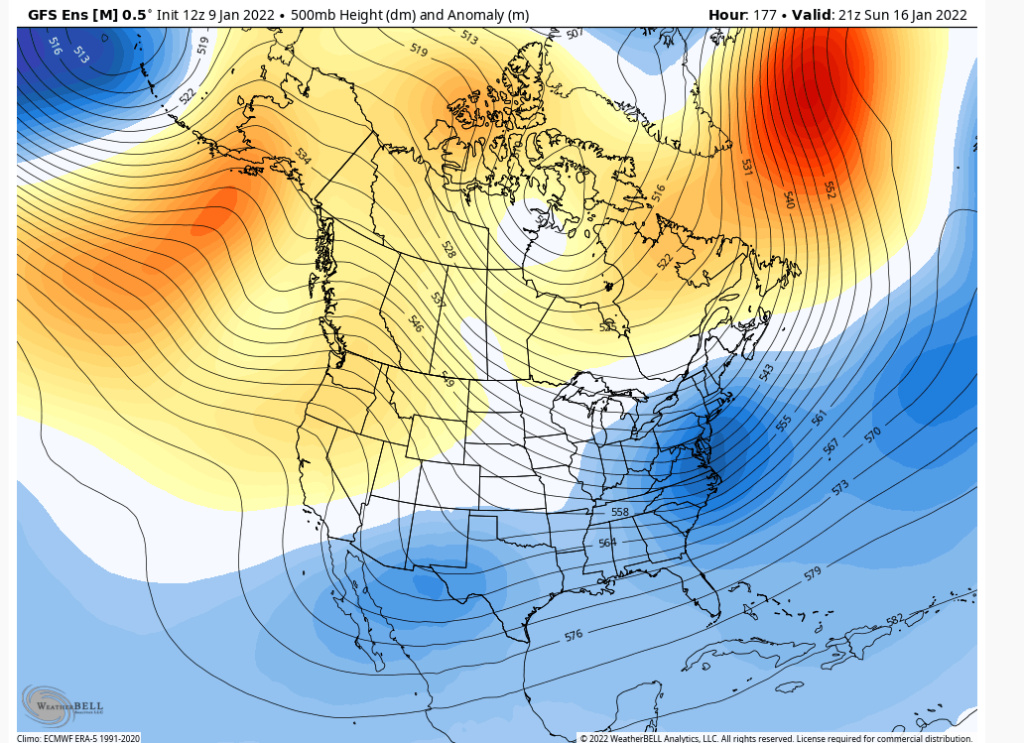
The GFS is slowly coming around to a storm on Sunday. Give it a day IMO for some changes on the op, but clearly the H5 ensembles between Canadian and GFS are similar. The ridging in west coast and the transient block in eastern North Atlantic are all similar. Canadian is much sharper trough and consequently fires up a much stronger storm whereas the GFS is flat and tends to push the storm OTS, but it's really quite remarkable similarity on the ensembles. Something be brewing as this is not a benign look...


heehaw453- Advanced Forecaster

- Posts : 3906
Reputation : 86
Join date : 2014-01-20
Location : Bedminster Township, PA Elevation 600' ASL
rb924119 and dolphins222 like this post
 Re: Long Range Discussion 22.0
This is the ORIGINAL period of interest highlighted by rb wan kenobi nearly a month ago.
Now, finally, it's been delivered to heehaw's medium range domain, where he and Mugsy can now just beat it into submission with optimistic and favorable updates for like 3 straight days...until finally....Voila! A snowstorm occurs this weekend, right on cue!
OK, a bit too optimistic and deterministic I suppose to call that analysis, but that's how the early season has gone so far...
SENJsnowman- Senior Enthusiast

- Posts : 1186
Reputation : 61
Join date : 2017-01-06
Age : 51
Location : Bayville, NJ
CPcantmeasuresnow, rb924119, jmanley32, heehaw453 and Bwtr like this post
 Re: Long Range Discussion 22.0
Trying to figure this forecast out is about as easy as trying to wrestle with a grizzly bear. Assessing the MJO is like trying to interpret a piece of abstract art, and then trying to assess the interplay of everything else on top of that with the evolving pattern is just brutal. But progress is being made. I think…..? Lmao
This is HARD.
This is HARD.
rb924119- Meteorologist

- Posts : 6890
Reputation : 194
Join date : 2013-02-06
Age : 32
Location : Greentown, Pa
 Re: Long Range Discussion 22.0
rb924119 wrote:Trying to figure this forecast out is about as easy as trying to wrestle with a grizzly bear. Assessing the MJO is like trying to interpret a piece of abstract art, and then trying to assess the interplay of everything else on top of that with the evolving pattern is just brutal. But progress is being made. I think…..? Lmao
This is HARD.
Since you mentioned “Field of Dreams”…I’ll raise you

MattyICE- Advanced Forecaster

- Posts : 249
Reputation : 6
Join date : 2017-11-10
Age : 38
Location : Clifton, NJ (Eastern Passaic County)
rb924119 likes this post
 Re: Long Range Discussion 22.0
Frank_Wx wrote:Like Al mentioned there are several waves of upper energy to watch by the time we get to next weekend. It’s possible the energy off the SE coast, which is the storm around the 14th, disrupts the flow downstream and prevents the storm on the 16th-17th from coming together. That said, look at how many pieces of energy models are having to focus on. We’re going to see drastic changes run to run. We’ll need to wait until Wednesday to really have a better idea of what’s going on with all of these. My guess is, the waves between 15th-17th don’t materialize for us, but we’ll have a better pattern from the 19th onward.
I think that I’ve finally come a conclusion for the threat on the 16th, and I think I agree with your above sentiment. I think that this is going to end up being an event for the Mid-Atlantic (Richmond, Baltimore/D.C. and maybe Cape May). It’s an unfortunate conclusion to come to, but with such a complex setup, my/our opinions may very well be wrong.
Video forthcoming explaining why and how I came to this conclusion/opinion.
Dunnz, I think you’ll be fine for the 13th. As previously stated, I think it misses wide right.
rb924119- Meteorologist

- Posts : 6890
Reputation : 194
Join date : 2013-02-06
Age : 32
Location : Greentown, Pa
Dunnzoo and heehaw453 like this post
 Re: Long Range Discussion 22.0
You guys are using OP 500mb maps a week out in this most volatile pattern with HUGE changes between the MJO in Phase 8, SOI crash, a cut off low in the Baja of Cali = Split Flow and STJ injection happening not to mention a NAO going Negative, EPO and PNA flipping with a PV entering the picture?
ENS peeps are teh way to go. In no way can one say this is a miss at the 15-17th time frame at this stage with all the aforementioned IMO.
Time will tell. GEFS and EURO ENS are showing some very good LP positions and indicy members. Just like Friday's storm models are going o struggle mightily until we are in a few days.
Time will tell but the Massive Ocean storm has a huge role in the follow up system. If that system doesn't exit quick enough than we may very miss the 15-17th but if it does than the follow up storm can come N.
_________________
Mugs
AKA:King: Snow Weenie
Self Proclaimed
WINTER 2014-15 : 55.12" +.02 for 6 coatings (avg. 35")
WINTER 2015-16 Total - 29.8" (Avg 35")
WINTER 2016-17 : 39.5" so far

amugs- Advanced Forecaster - Mod

- Posts : 15093
Reputation : 213
Join date : 2013-01-07
Age : 54
Location : Hillsdale,NJ
CPcantmeasuresnow likes this post
 Re: Long Range Discussion 22.0
amugs wrote:You guys are using OP 500mb maps a week out in this most volatile pattern with HUGE changes between the MJO in Phase 8, SOI crash, a cut off low in the Baja of Cali = Split Flow and STJ injection happening not to mention a NAO going Negative, EPO and PNA flipping with a PV entering the picture?
ENS peeps are teh way to go. In no way can one say this is a miss at the 15-17th time frame at this stage with all the aforementioned IMO.
Time will tell. GEFS and EURO ENS are showing some very good LP positions and indicy members. Just like Friday's storm models are going o struggle mightily until we are in a few days.
Time will tell but the Massive Ocean storm has a huge role in the follow up system. If that system doesn't exit quick enough than we may very miss the 15-17th but if it does than the follow up storm can come N.
Mugsy, calm down brother haha they weren’t using that GFS map as a forecast, they were using it to illustrate the mass chaos that the models have to try to predict, and explain that high model volatility and drastic swing swings from run to run will continue for several days yet before they start getting a better idea. Frank just followed up with his own opinion on the 16th event specifically. I then followed up on Frank with my opinion, and my reasoning will be provided shortly (video is currently uploading and then has to be processed by the server).
I said that the conclusion that I have come to was disappointing because this has been a time period that I thought we would capitalize on, and we still might! But, my opinion has now changed basis my latest analysis. Just trying to be objective with my outlooks and give everybody the best information that I possibly can. Nothing says that I’m right
rb924119- Meteorologist

- Posts : 6890
Reputation : 194
Join date : 2013-02-06
Age : 32
Location : Greentown, Pa
heehaw453 likes this post
 Re: Long Range Discussion 22.0
amugs wrote:You guys are using OP 500mb maps a week out in this most volatile pattern with HUGE changes between the MJO in Phase 8, SOI crash, a cut off low in the Baja of Cali = Split Flow and STJ injection happening not to mention a NAO going Negative, EPO and PNA flipping with a PV entering the picture?
ENS peeps are teh way to go. In no way can one say this is a miss at the 15-17th time frame at this stage with all the aforementioned IMO.
Time will tell. GEFS and EURO ENS are showing some very good LP positions and indicy members. Just like Friday's storm models are going o struggle mightily until we are in a few days.
Time will tell but the Massive Ocean storm has a huge role in the follow up system. If that system doesn't exit quick enough than we may very miss the 15-17th but if it does than the follow up storm can come N.
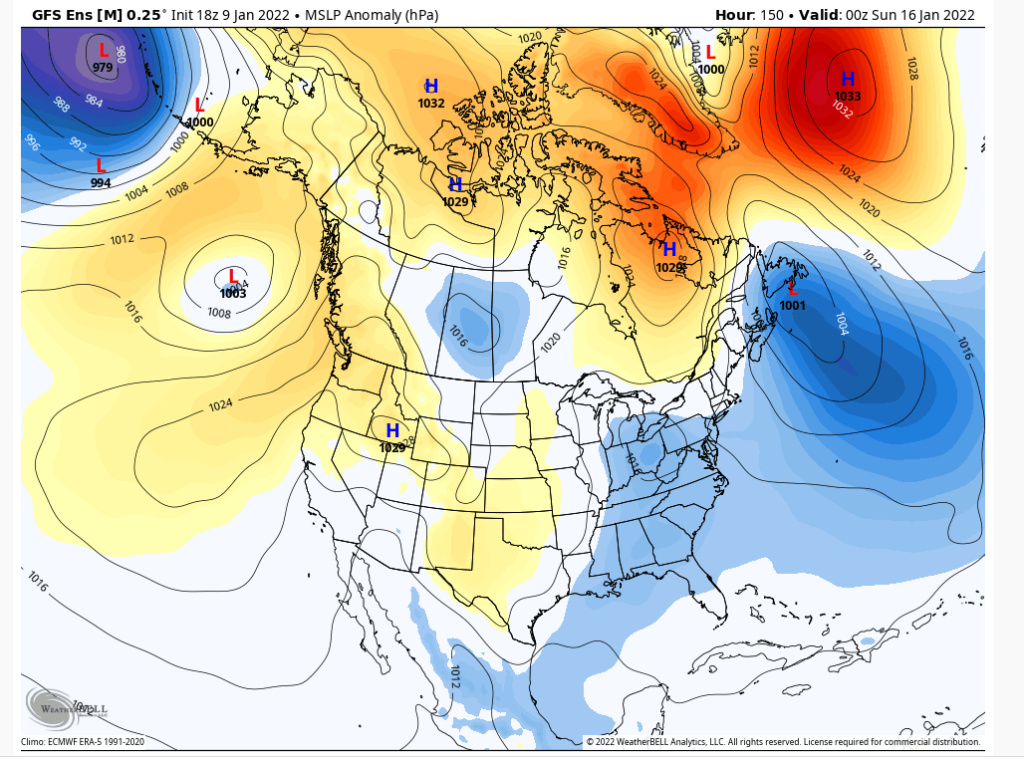
Too early to bail on it. The issue I see on EPS guidance is the block isn't as strong especially west of the main east based block which allows the 50/50 low to slip away quickly. This gives room for the mid atlantic storm to move on out. The Canadian is a stronger block west of the east based block and keeps the mid atlantic storm at bay allowing it to mature below our latitude and be closer to the coast. The GEFS is closer to the Canadian but actually stronger blocking. The transient NAO IMO is the key and usually big storms for the northeast are most heavily waited on that feature. It's all about timing...
Top in Euro ensembles and bottom is GFS ensembles. That's a big difference.

heehaw453- Advanced Forecaster

- Posts : 3906
Reputation : 86
Join date : 2014-01-20
Location : Bedminster Township, PA Elevation 600' ASL
 Re: Long Range Discussion 22.0
heehaw453 wrote:amugs wrote:You guys are using OP 500mb maps a week out in this most volatile pattern with HUGE changes between the MJO in Phase 8, SOI crash, a cut off low in the Baja of Cali = Split Flow and STJ injection happening not to mention a NAO going Negative, EPO and PNA flipping with a PV entering the picture?
ENS peeps are teh way to go. In no way can one say this is a miss at the 15-17th time frame at this stage with all the aforementioned IMO.
Time will tell. GEFS and EURO ENS are showing some very good LP positions and indicy members. Just like Friday's storm models are going o struggle mightily until we are in a few days.
Time will tell but the Massive Ocean storm has a huge role in the follow up system. If that system doesn't exit quick enough than we may very miss the 15-17th but if it does than the follow up storm can come N.
Too early to bail on it. The issue I see on EPS guidance is the block isn't as strong especially west of the main east based block which allows the 50/50 low to slip away quickly. This gives room for the mid atlantic storm to move on out. The Canadian is a stronger block west of the east based block and keeps the mid atlantic storm at bay allowing it to mature below our latitude and be closer to the coast. The GEFS is closer to the Canadian but actually stronger blocking. The transient NAO IMO is the key and usually big storms for the northeast are most heavily waited on that feature. It's all about timing...
Top in Euro ensembles and bottom is GFS ensembles. That's a big difference.
Interesting view! I’m actually of an opposing view point. Kind of lol I think the block itself is displaced too far equatorward and the departing storm from the 13th is too slow. This combination will be compounded by hemispheric and tropical forcings to keep the height field too suppressed for storm on the 16th to gain sufficient latitude once it develops, and instead be forced straight out to sea.
rb924119- Meteorologist

- Posts : 6890
Reputation : 194
Join date : 2013-02-06
Age : 32
Location : Greentown, Pa
 Re: Long Range Discussion 22.0
rb924119 wrote:heehaw453 wrote:amugs wrote:You guys are using OP 500mb maps a week out in this most volatile pattern with HUGE changes between the MJO in Phase 8, SOI crash, a cut off low in the Baja of Cali = Split Flow and STJ injection happening not to mention a NAO going Negative, EPO and PNA flipping with a PV entering the picture?
ENS peeps are teh way to go. In no way can one say this is a miss at the 15-17th time frame at this stage with all the aforementioned IMO.
Time will tell. GEFS and EURO ENS are showing some very good LP positions and indicy members. Just like Friday's storm models are going o struggle mightily until we are in a few days.
Time will tell but the Massive Ocean storm has a huge role in the follow up system. If that system doesn't exit quick enough than we may very miss the 15-17th but if it does than the follow up storm can come N.
Too early to bail on it. The issue I see on EPS guidance is the block isn't as strong especially west of the main east based block which allows the 50/50 low to slip away quickly. This gives room for the mid atlantic storm to move on out. The Canadian is a stronger block west of the east based block and keeps the mid atlantic storm at bay allowing it to mature below our latitude and be closer to the coast. The GEFS is closer to the Canadian but actually stronger blocking. The transient NAO IMO is the key and usually big storms for the northeast are most heavily waited on that feature. It's all about timing...
Top in Euro ensembles and bottom is GFS ensembles. That's a big difference.
Interesting view! I’m actually of an opposing view point. Kind of lol I think the block itself is displaced too far equatorward and the departing storm from the 13th is too slow. This combination will be compounded by hemispheric and tropical forcings to keep the height field too suppressed for storm on the 16th to gain sufficient latitude once it develops, and instead be forced straight out to sea.
I totally can see that Rb. It's going to be interesting the next few days to see how guidance resolves this.
heehaw453- Advanced Forecaster

- Posts : 3906
Reputation : 86
Join date : 2014-01-20
Location : Bedminster Township, PA Elevation 600' ASL
rb924119 likes this post
Page 24 of 31 •  1 ... 13 ... 23, 24, 25 ... 27 ... 31
Page 24 of 31
Permissions in this forum:
You cannot reply to topics in this forum|
|
|

 Home
Home