
 Search
January 7th 2022 Snowstorm Threat
Page 1 of 15 • 1, 2, 3 ... 8 ... 15 ![]()

January 7th 2022 Snowstorm Threat
![]() by Frank_Wx Tue Jan 04, 2022 8:04 am
by Frank_Wx Tue Jan 04, 2022 8:04 am
Southern portions of our area saw a nice snowfall yesterday. The precip did not get very far north, which I had a feeling would happen and is why I took this threat off the SCI list. But then almost all models showed some form of accumulation into NYC just 36 hours before and I figured the northern trend was real. That wasn’t the case, and the 2-4 call for NYC busted.
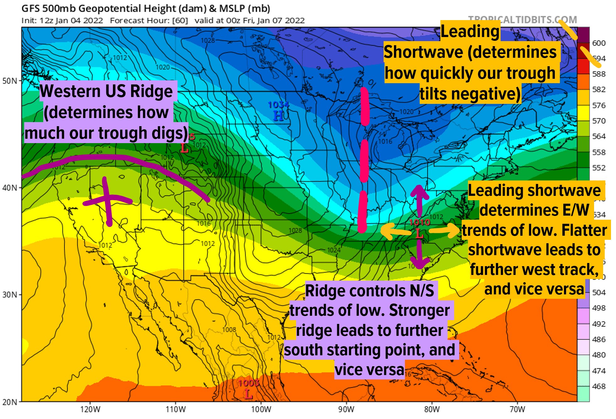
Luckily we can quickly forget and focus on the next storm threat for this Friday. This event also boils down to wave spacing. With yesterday’s storm, there was not sufficient space for the low pressure to amplify because of depressed heights over the region from last weekends cold front. So it stayed to our south. With Fridays event, I am noticing a similar trend. The NAM, which is the most aggressive with bringing Mothrazilla type of snow to the area, has the main energy digging into the OH valley ahead of an amplifying western ridge spike. Heights along the EC rise in response to the developing storm which allows the low pressure to stay near the coast and lash the area with heavy snow. GFS does not think the upper air energy will dig like the NAM has it. Mostly because of a more flatter western ridge and lower heights along the EC due to a separate piece of upper energy that’s dragged across New England. The atmosphere looks “too busy” on the GFS whereas on the NAM things are falling into place smoother.
So, we don’t have the answers right now. That said, even the GFS shows a 1-3” snowfall so pretty much all guidance shows some form of snow. But, I’m not excited yet because I can see an easy way how this storm never materializes or organizes too Far East. Where the Arctic boundary sets up is key. And where it decides to set up depends on the path of the upper energy which is driven by the flow downstream ahead of a spiking ridge. We’ll see how models trend in the coming days.
_________________
_______________________________________________________________________________________________________
CLICK HERE to view NJ Strong Snowstorm Classifications

Frank_Wx- Godzilla Seeker

- Posts : 21305
Reputation : 328
Join date : 2013-01-05
Age : 32
Location : Jersey City, NJ -

rb924119 likes this post
Re: January 7th 2022 Snowstorm Threat
![]() by dsix85 Tue Jan 04, 2022 8:06 am
by dsix85 Tue Jan 04, 2022 8:06 am
dsix85- Pro Enthusiast

- Posts : 349
Reputation : 8
Join date : 2014-01-01
Location : New York
rb924119 likes this post
Re: January 7th 2022 Snowstorm Threat
![]() by heehaw453 Tue Jan 04, 2022 8:18 am
by heehaw453 Tue Jan 04, 2022 8:18 am
GFS ensembles mean low pressure is inside BM last few runs and it's more potent than before. Euro ensembles are keeping the wave around BM and less potent at our latitude. The difference is how far the 500mb trough is being placed.
Frank is absolutely correct that we don't have the necessary clarity on this one yet, however just based on synoptics I think moderate event is a realistic possibility ATTM.
heehaw453- Advanced Forecaster

- Posts : 3906
Reputation : 86
Join date : 2014-01-20
Location : Bedminster Township, PA Elevation 600' ASL
rb924119 likes this post
Re: January 7th 2022 Snowstorm Threat
![]() by heehaw453 Tue Jan 04, 2022 8:31 am
by heehaw453 Tue Jan 04, 2022 8:31 am

heehaw453- Advanced Forecaster
- Posts : 3906
Reputation : 86
Join date : 2014-01-20
Location : Bedminster Township, PA Elevation 600' ASL
rb924119 likes this post
Re: January 7th 2022 Snowstorm Threat
![]() by dsix85 Tue Jan 04, 2022 8:36 am
by dsix85 Tue Jan 04, 2022 8:36 am
dsix85- Pro Enthusiast
- Posts : 349
Reputation : 8
Join date : 2014-01-01
Location : New York
rb924119 likes this post
Re: January 7th 2022 Snowstorm Threat
![]() by heehaw453 Tue Jan 04, 2022 8:44 am
by heehaw453 Tue Jan 04, 2022 8:44 am
Yeah quick hitter I think is high confidence bet.dsix85 wrote:Given the progressive flow, I assume this would be a quick hitter, maybe a 12ish hour event ?
heehaw453- Advanced Forecaster
- Posts : 3906
Reputation : 86
Join date : 2014-01-20
Location : Bedminster Township, PA Elevation 600' ASL
rb924119 likes this post
Re: January 7th 2022 Snowstorm Threat
![]() by Frank_Wx Tue Jan 04, 2022 8:44 am
by Frank_Wx Tue Jan 04, 2022 8:44 am
dsix85 wrote:Given the progressive flow, I assume this would be a quick hitter, maybe a 12ish hour event ?
8-12 hours, yes.
_________________
_______________________________________________________________________________________________________
CLICK HERE to view NJ Strong Snowstorm Classifications
Frank_Wx- Godzilla Seeker
- Posts : 21305
Reputation : 328
Join date : 2013-01-05
Age : 32
Location : Jersey City, NJ -
rb924119 and phil155 like this post
Re: January 7th 2022 Snowstorm Threat
![]() by amugs Tue Jan 04, 2022 10:54 am
by amugs Tue Jan 04, 2022 10:54 am
Critical feature to monitor. W/the height field compressed over the NE, that limits the ceiling as the follow-up wave's ability to amplify is curtailed. But it also prevents a storm track inland. 12z NAM follows suit w/this feature, but plenty of time for changes in this regard. https://t.co/kFL9v8kaw5 pic.twitter.com/WA00UsYJVF
— Mike Mostwill (@MikeMostwill) January 4, 2022
_________________
Mugs
AKA:King: Snow Weenie
Self Proclaimed
WINTER 2014-15 : 55.12" +.02 for 6 coatings (avg. 35")
WINTER 2015-16 Total - 29.8" (Avg 35")
WINTER 2016-17 : 39.5" so far

amugs- Advanced Forecaster - Mod

- Posts : 15095
Reputation : 213
Join date : 2013-01-07
Age : 54
Location : Hillsdale,NJ
Re: January 7th 2022 Snowstorm Threat
![]() by heehaw453 Tue Jan 04, 2022 11:13 am
by heehaw453 Tue Jan 04, 2022 11:13 am

heehaw453- Advanced Forecaster
- Posts : 3906
Reputation : 86
Join date : 2014-01-20
Location : Bedminster Township, PA Elevation 600' ASL
Re: January 7th 2022 Snowstorm Threat
![]() by heehaw453 Tue Jan 04, 2022 12:11 pm
by heehaw453 Tue Jan 04, 2022 12:11 pm
heehaw453- Advanced Forecaster
- Posts : 3906
Reputation : 86
Join date : 2014-01-20
Location : Bedminster Township, PA Elevation 600' ASL
Re: January 7th 2022 Snowstorm Threat
![]() by SoulSingMG Tue Jan 04, 2022 12:15 pm
by SoulSingMG Tue Jan 04, 2022 12:15 pm

SoulSingMG- Senior Enthusiast

- Posts : 2853
Reputation : 74
Join date : 2013-12-11
Location : Long Island City, NY
Re: January 7th 2022 Snowstorm Threat
![]() by phil155 Tue Jan 04, 2022 12:17 pm
by phil155 Tue Jan 04, 2022 12:17 pm
dsix85 wrote:Bernie more convinced on a potential I-95 special. https://twitter.com/accurayno/status/1478350494896734214?s=21
Seems like Bernie thinks this is most likely west of the 95 corridor
phil155- Pro Enthusiast
- Posts : 483
Reputation : 4
Join date : 2019-12-16
CPcantmeasuresnow likes this post
Re: January 7th 2022 Snowstorm Threat
![]() by aiannone Tue Jan 04, 2022 12:44 pm
by aiannone Tue Jan 04, 2022 12:44 pm
_________________
-Alex Iannone-

aiannone- Senior Enthusiast - Mod
- Posts : 4815
Reputation : 92
Join date : 2013-01-07
Location : Saint James, LI (Northwest Suffolk Co.)
Re: January 7th 2022 Snowstorm Threat
![]() by amugs Tue Jan 04, 2022 1:34 pm
by amugs Tue Jan 04, 2022 1:34 pm
Nikhil Trivedi
_________________
Mugs
AKA:King: Snow Weenie
Self Proclaimed
WINTER 2014-15 : 55.12" +.02 for 6 coatings (avg. 35")
WINTER 2015-16 Total - 29.8" (Avg 35")
WINTER 2016-17 : 39.5" so far
amugs- Advanced Forecaster - Mod
- Posts : 15095
Reputation : 213
Join date : 2013-01-07
Age : 54
Location : Hillsdale,NJ
Re: January 7th 2022 Snowstorm Threat
![]() by heehaw453 Tue Jan 04, 2022 1:40 pm
by heehaw453 Tue Jan 04, 2022 1:40 pm
heehaw453- Advanced Forecaster
- Posts : 3906
Reputation : 86
Join date : 2014-01-20
Location : Bedminster Township, PA Elevation 600' ASL
Re: January 7th 2022 Snowstorm Threat
![]() by MattyICE Tue Jan 04, 2022 1:53 pm
by MattyICE Tue Jan 04, 2022 1:53 pm
MattyICE- Advanced Forecaster
- Posts : 249
Reputation : 6
Join date : 2017-11-10
Age : 38
Location : Clifton, NJ (Eastern Passaic County)
rb924119 and SENJsnowman like this post
Re: January 7th 2022 Snowstorm Threat
![]() by aiannone Tue Jan 04, 2022 1:53 pm
by aiannone Tue Jan 04, 2022 1:53 pm
_________________
-Alex Iannone-
aiannone- Senior Enthusiast - Mod
- Posts : 4815
Reputation : 92
Join date : 2013-01-07
Location : Saint James, LI (Northwest Suffolk Co.)
heehaw453 likes this post
Re: January 7th 2022 Snowstorm Threat
![]() by aiannone Tue Jan 04, 2022 1:56 pm
by aiannone Tue Jan 04, 2022 1:56 pm
The main reason I'm skeptical we'll see a shift is that precipitation is much less correlated with low-level warm air advection & frontogenesis than other storms (compare red+purple max here to snow above).
— Nick P Bassill (@NickPBassill) January 4, 2022
These are often a basis for snowbands shifting north in my experience... pic.twitter.com/t3OfxugKY4
_________________
-Alex Iannone-
aiannone- Senior Enthusiast - Mod
- Posts : 4815
Reputation : 92
Join date : 2013-01-07
Location : Saint James, LI (Northwest Suffolk Co.)
Re: January 7th 2022 Snowstorm Threat
![]() by amugs Tue Jan 04, 2022 2:14 pm
by amugs Tue Jan 04, 2022 2:14 pm
aiannone wrote:The upper level energy is coming ashore later today so the 00z runs will be big
Question is when because 0Z runs data is sampled 5 hours before teh run and will it be fully sampled.
_________________
Mugs
AKA:King: Snow Weenie
Self Proclaimed
WINTER 2014-15 : 55.12" +.02 for 6 coatings (avg. 35")
WINTER 2015-16 Total - 29.8" (Avg 35")
WINTER 2016-17 : 39.5" so far
amugs- Advanced Forecaster - Mod
- Posts : 15095
Reputation : 213
Join date : 2013-01-07
Age : 54
Location : Hillsdale,NJ
Re: January 7th 2022 Snowstorm Threat
![]() by amugs Tue Jan 04, 2022 2:29 pm
by amugs Tue Jan 04, 2022 2:29 pm
Updated 12z GEFS tracks. Control is near 40/70 with a fairly tight cluster to the ESE and quite a few off to the WNW pic.twitter.com/1M4udMeyrN
— Anthony Siciliano (@AMSweather) January 4, 2022
_________________
Mugs
AKA:King: Snow Weenie
Self Proclaimed
WINTER 2014-15 : 55.12" +.02 for 6 coatings (avg. 35")
WINTER 2015-16 Total - 29.8" (Avg 35")
WINTER 2016-17 : 39.5" so far
amugs- Advanced Forecaster - Mod
- Posts : 15095
Reputation : 213
Join date : 2013-01-07
Age : 54
Location : Hillsdale,NJ
Re: January 7th 2022 Snowstorm Threat
![]() by amugs Tue Jan 04, 2022 2:31 pm
by amugs Tue Jan 04, 2022 2:31 pm
Vort is stronger and WC ridge is fine just need that energy to lift up and out faster and be weaker. Need a bit more separation for this to work well for our area.

_________________
Mugs
AKA:King: Snow Weenie
Self Proclaimed
WINTER 2014-15 : 55.12" +.02 for 6 coatings (avg. 35")
WINTER 2015-16 Total - 29.8" (Avg 35")
WINTER 2016-17 : 39.5" so far
amugs- Advanced Forecaster - Mod
- Posts : 15095
Reputation : 213
Join date : 2013-01-07
Age : 54
Location : Hillsdale,NJ
Re: January 7th 2022 Snowstorm Threat
![]() by Frank_Wx Tue Jan 04, 2022 2:44 pm
by Frank_Wx Tue Jan 04, 2022 2:44 pm
amugs wrote:EPS further SE - the storm tomorrow vorticity is stronger on teh EURO and EPS doesn't allow heights to recover so the storm can climb in latitude and slips ESE.
Vort is stronger and WC ridge is fine just need that energy to lift up and out faster and be weaker. Need a bit more separation for this to work well for our area.
Yea…this touches on the wave spacing I mentioned. Still time left to correct this. There’s a pesky trough directly south of Greenland that is churning the energies downstream.
_________________
_______________________________________________________________________________________________________
CLICK HERE to view NJ Strong Snowstorm Classifications
Frank_Wx- Godzilla Seeker
- Posts : 21305
Reputation : 328
Join date : 2013-01-05
Age : 32
Location : Jersey City, NJ -
Re: January 7th 2022 Snowstorm Threat
![]() by aiannone Tue Jan 04, 2022 3:43 pm
by aiannone Tue Jan 04, 2022 3:43 pm

18z NAM was 1-3" east of 95
_________________
-Alex Iannone-
aiannone- Senior Enthusiast - Mod
- Posts : 4815
Reputation : 92
Join date : 2013-01-07
Location : Saint James, LI (Northwest Suffolk Co.)
Re: January 7th 2022 Snowstorm Threat
![]() by heehaw453 Tue Jan 04, 2022 3:59 pm
by heehaw453 Tue Jan 04, 2022 3:59 pm
Last edited by heehaw453 on Tue Jan 04, 2022 4:12 pm; edited 1 time in total
heehaw453- Advanced Forecaster
- Posts : 3906
Reputation : 86
Join date : 2014-01-20
Location : Bedminster Township, PA Elevation 600' ASL
Re: January 7th 2022 Snowstorm Threat
![]() by CPcantmeasuresnow Tue Jan 04, 2022 4:10 pm
by CPcantmeasuresnow Tue Jan 04, 2022 4:10 pm
aiannone wrote:
18z NAM was 1-3" east of 95
Hope that changes because boring comes to mind with this depiction as is.

CPcantmeasuresnow- Wx Statistician Guru

- Posts : 7274
Reputation : 230
Join date : 2013-01-07
Age : 103
Location : Eastern Orange County, NY
Page 1 of 15 • 1, 2, 3 ... 8 ... 15 ![]()
|
|
|