January 7th 2022 Snowstorm Threat
Page 3 of 15 •  1, 2, 3, 4 ... 9 ... 15
 Re: January 7th 2022 Snowstorm Threat
Sanchize06- Senior Enthusiast

- Posts : 1041
Join date : 2013-02-05
 Re: January 7th 2022 Snowstorm Threat
heehaw453- Advanced Forecaster

- Posts : 3906
Join date : 2014-01-20
 Re: January 7th 2022 Snowstorm Threat

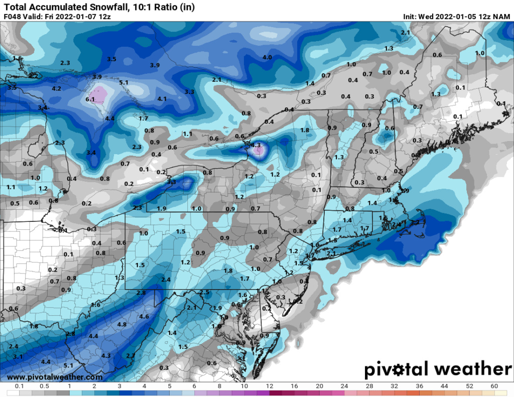
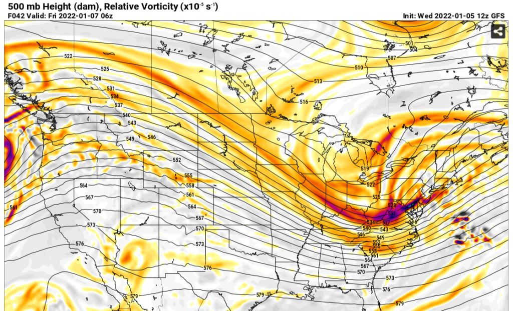
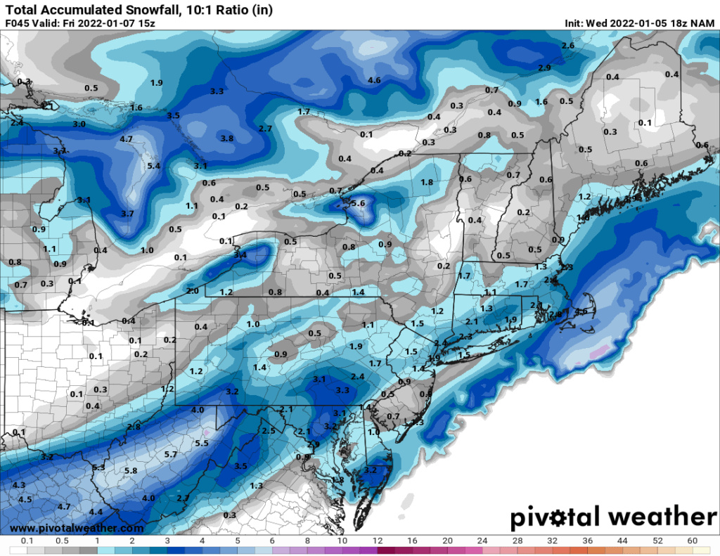
But the NAM is successful in developing a trough and consolidating the energy at the base much earlier than the GFS, which allows the low to mature faster and raise heights along the east coast. This keeps the storm tracking more west instead of slip east.

_________________
_______________________________________________________________________________________________________
CLICK HERE to view NJ Strong Snowstorm Classifications
heehaw453 likes this post
 Re: January 7th 2022 Snowstorm Threat
dsix85- Pro Enthusiast

- Posts : 349
Reputation : 8
Join date : 2014-01-01
Location : New York
 Re: January 7th 2022 Snowstorm Threat
_________________
_______________________________________________________________________________________________________
CLICK HERE to view NJ Strong Snowstorm Classifications
heehaw453 likes this post
 Re: January 7th 2022 Snowstorm Threat
The first HRRR run is in range for Friday’s storm, and is not only quite amplified, but showing a strong signal for an intense snow band that should it verify, could lead to an overperformer along and/or NW of I-95. pic.twitter.com/mzlHLUNeyy
— Tomer Burg (@burgwx) January 5, 2022
This was my first guess map as of yesterday — I’ll update it again later this afternoon.
— Tomer Burg (@burgwx) January 5, 2022
I’m going to be cautious here since my last guess siding with a NW trend failed, but I do see a *potential* here for a slight NW adjustment & narrow 5-10” corridor from N NJ northeastward. pic.twitter.com/bQCHZj2MIt
_________________
Mugs
AKA:King: Snow Weenie
Self Proclaimed
WINTER 2014-15 : 55.12" +.02 for 6 coatings (avg. 35")
WINTER 2015-16 Total - 29.8" (Avg 35")
WINTER 2016-17 : 39.5" so far

amugs- Advanced Forecaster - Mod

- Posts : 15095
Reputation : 213
Join date : 2013-01-07
Age : 54
Location : Hillsdale,NJ

aiannone- Senior Enthusiast - Mod

- Posts : 4815
Reputation : 92
Join date : 2013-01-07
Location : Saint James, LI (Northwest Suffolk Co.)
 Re: January 7th 2022 Snowstorm Threat
heehaw453- Advanced Forecaster

- Posts : 3906
Reputation : 86
Join date : 2014-01-20
Location : Bedminster Township, PA Elevation 600' ASL
 Re: January 7th 2022 Snowstorm Threat
heehaw453- Advanced Forecaster

- Posts : 3906
Reputation : 86
Join date : 2014-01-20
Location : Bedminster Township, PA Elevation 600' ASL
 Re: January 7th 2022 Snowstorm Threat
MattyICE- Advanced Forecaster

- Posts : 249
Reputation : 6
Join date : 2017-11-10
Age : 38
Location : Clifton, NJ (Eastern Passaic County)
CPcantmeasuresnow, essexcountypete and heehaw453 like this post
 Re: January 7th 2022 Snowstorm Threat
MattyICE wrote:IMO the NAM, at least for now and until it can stumble upon two consecutive runs that are remotely similar, has to be discounted regardless of whether it brings us a widespread warning criteria event or a barely nuisance level event.
Yeah, NAM is always going to give extreme solutions, but both solutions ATTM are extremely viable. It's very complex on how that s/w develops. Just the right or wrong tilt/spin makes all the difference in the world.
heehaw453- Advanced Forecaster

- Posts : 3906
Reputation : 86
Join date : 2014-01-20
Location : Bedminster Township, PA Elevation 600' ASL
essexcountypete and MattyICE like this post
heehaw453- Advanced Forecaster

- Posts : 3906
Reputation : 86
Join date : 2014-01-20
Location : Bedminster Township, PA Elevation 600' ASL

aiannone- Senior Enthusiast - Mod

- Posts : 4815
Reputation : 92
Join date : 2013-01-07
Location : Saint James, LI (Northwest Suffolk Co.)
 Re: January 7th 2022 Snowstorm Threat
Key to Thursday night snow and how much resides with this weak low coming north from the Bahamas. NAM/GFS jumps the primary to this low quicker resulting in less snow N/W of the low. RGEM, HRRR, and Euro do not as quickly, and more snow is found NW since the primary holds longer. pic.twitter.com/l8By4RpACx
— Bobby Martrich | EPAWA Meteorologist ☈ (@epawawx) January 5, 2022
Interesting
_________________
Mugs
AKA:King: Snow Weenie
Self Proclaimed
WINTER 2014-15 : 55.12" +.02 for 6 coatings (avg. 35")
WINTER 2015-16 Total - 29.8" (Avg 35")
WINTER 2016-17 : 39.5" so far

amugs- Advanced Forecaster - Mod

- Posts : 15095
Reputation : 213
Join date : 2013-01-07
Age : 54
Location : Hillsdale,NJ
phil155 likes this post
 Re: January 7th 2022 Snowstorm Threat


_________________
"In weather and in life, there's no winning and losing; there's only winning and learning."
WINTER 2012/2013 TOTALS 43.65"WINTER 2017/2018 TOTALS 62.85" WINTER 2022/2023 TOTALS 4.9"
WINTER 2013/2014 TOTALS 64.85"WINTER 2018/2019 TOTALS 14.25" WINTER 2023/2024 TOTALS 13.1"
WINTER 2014/2015 TOTALS 71.20"WINTER 2019/2020 TOTALS 6.35"
WINTER 2015/2016 TOTALS 35.00"WINTER 2020/2021 TOTALS 37.75"
WINTER 2016/2017 TOTALS 42.25"WINTER 2021/2022 TOTALS 31.65"

sroc4- Admin

- Posts : 8354
Reputation : 302
Join date : 2013-01-07
Location : Wading River, LI
jmanley32, SENJsnowman and phil155 like this post
 Re: January 7th 2022 Snowstorm Threat
Rayno still harping on a 3-6" snowfall for NNJ through ELI and into CT.
Same read from Paul Dorian
https://arcfieldweather.com/blog/2022/1/5/j0gsdi9byd5urzlcq0gi82zlyoditb
_________________
Mugs
AKA:King: Snow Weenie
Self Proclaimed
WINTER 2014-15 : 55.12" +.02 for 6 coatings (avg. 35")
WINTER 2015-16 Total - 29.8" (Avg 35")
WINTER 2016-17 : 39.5" so far

amugs- Advanced Forecaster - Mod

- Posts : 15095
Reputation : 213
Join date : 2013-01-07
Age : 54
Location : Hillsdale,NJ
 Re: January 7th 2022 Snowstorm Threat

nutleyblizzard- Senior Enthusiast

- Posts : 1954
Reputation : 41
Join date : 2014-01-30
Age : 58
Location : Nutley, new jersey
 Re: January 7th 2022 Snowstorm Threat
_________________
Mugs
AKA:King: Snow Weenie
Self Proclaimed
WINTER 2014-15 : 55.12" +.02 for 6 coatings (avg. 35")
WINTER 2015-16 Total - 29.8" (Avg 35")
WINTER 2016-17 : 39.5" so far

amugs- Advanced Forecaster - Mod

- Posts : 15095
Reputation : 213
Join date : 2013-01-07
Age : 54
Location : Hillsdale,NJ
 Re: January 7th 2022 Snowstorm Threat
Of course the reality is always if you’re five to ten miles outside or God forbid in between two of the bands you’re most likely scrooed.
Last edited by CPcantmeasuresnow on Wed Jan 05, 2022 1:11 pm; edited 1 time in total

CPcantmeasuresnow- Wx Statistician Guru

- Posts : 7274
Reputation : 230
Join date : 2013-01-07
Age : 103
Location : Eastern Orange County, NY
phil155 likes this post
heehaw453- Advanced Forecaster

- Posts : 3906
Reputation : 86
Join date : 2014-01-20
Location : Bedminster Township, PA Elevation 600' ASL
 Re: January 7th 2022 Snowstorm Threat
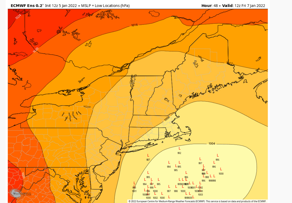
nutleyblizzard wrote:It’s becoming apparent that the global and hi-res models are having convection issues. The 12z RGEM for example had a low just off the coast then it jumped to a convection blob offshore. Then it inexplicably transferred back to the coast followed by transferring once again to an offshore low. Like that’s going to happen. Also we’re dealing with a small disturbance north of the Bahamas that can throw a monkey wrench into the forecast. I don’t think the models will have a clue until 0z or even 12z tomorrow. Until then windshield wiper is in effect.
I wouldn’t focus so much on where the specific “L” shows up. No it wouldn’t happen like you say, but it would be indicative of there being strung out energies and multiple centers trying to figure out who wants to be primary and who should transfer energy to whom. That’s my interpretation Which is very real and what will limit how powerful a storm can get.
MattyICE- Advanced Forecaster

- Posts : 249
Reputation : 6
Join date : 2017-11-10
Age : 38
Location : Clifton, NJ (Eastern Passaic County)
 Re: January 7th 2022 Snowstorm Threat
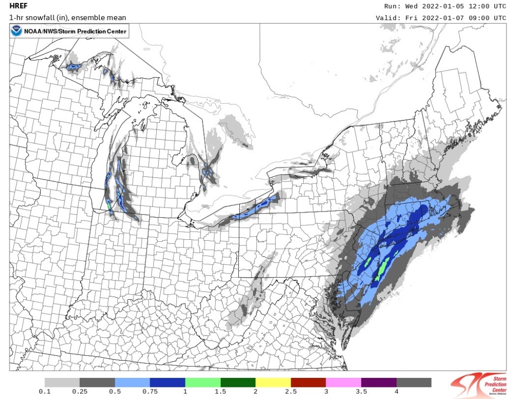
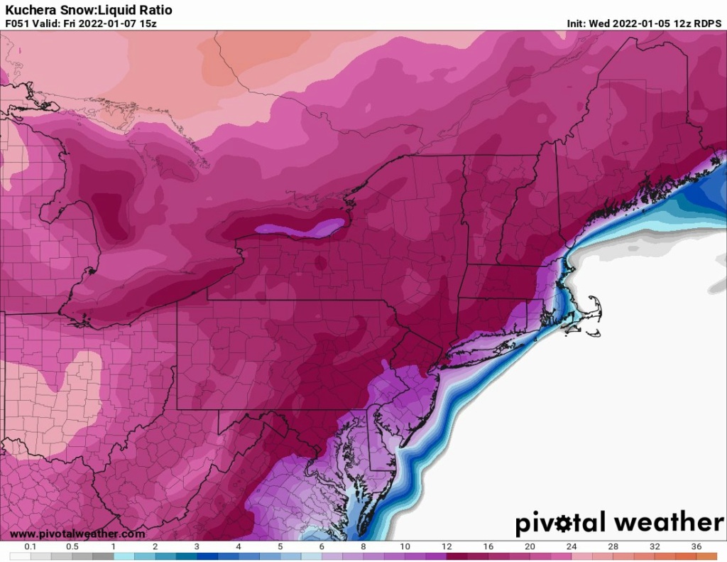
SROC pointed it out before with the 3K NAM and the HRRR and HREFs have it as well as the RGEM. Very interesting for sure.
Where and if this PVA sets up can be the difference between 2" and 4".
Also ratios will be 12:15-1 in NNJ on North.
_________________
Mugs
AKA:King: Snow Weenie
Self Proclaimed
WINTER 2014-15 : 55.12" +.02 for 6 coatings (avg. 35")
WINTER 2015-16 Total - 29.8" (Avg 35")
WINTER 2016-17 : 39.5" so far

amugs- Advanced Forecaster - Mod

- Posts : 15095
Reputation : 213
Join date : 2013-01-07
Age : 54
Location : Hillsdale,NJ
 Re: January 7th 2022 Snowstorm Threat
CPcantmeasuresnow wrote:That’s a fairly large area of a half inch of liquid which of course is almost double that in the meso bands. I’d sign up for that without a second thought, even without being under one of the bands.
Of course the reality is always if you’re five to ten miles outside or God forbid in between two of the bands you’re most likely scrooed.
CP, that map that Mugs posted is indicating how much snow could potentially fall per hour depending on the max banding we get, not liquid QPF. In our areas we could potentially be in .50-.75 per hour for a time if we get some banding. I think us folks N and W will see 2-3, maybe 4 if things work out. It's better than nothing I guess.

hyde345- Pro Enthusiast

- Posts : 1082
Reputation : 48
Join date : 2013-01-08
Location : Hyde Park, NY
CPcantmeasuresnow likes this post
 Re: January 7th 2022 Snowstorm Threat
hyde345 wrote:CPcantmeasuresnow wrote:That’s a fairly large area of a half inch of liquid which of course is almost double that in the meso bands. I’d sign up for that without a second thought, even without being under one of the bands.
Of course the reality is always if you’re five to ten miles outside or God forbid in between two of the bands you’re most likely scrooed.
CP, that map that Mugs posted is indicating how much snow could potentially fall per hour depending on the max banding we get, not liquid QPF. In our areas we could potentially be in .50-.75 per hour for a time if we get some banding. I think us folks N and W will see 2-3, maybe 4 if things work out. It's better than nothing I guess.
Thanks Hyde. I thought that was to good to be true.

CPcantmeasuresnow- Wx Statistician Guru

- Posts : 7274
Reputation : 230
Join date : 2013-01-07
Age : 103
Location : Eastern Orange County, NY
hyde345 likes this post
 Re: January 7th 2022 Snowstorm Threat
heehaw453- Advanced Forecaster

- Posts : 3906
Reputation : 86
Join date : 2014-01-20
Location : Bedminster Township, PA Elevation 600' ASL
 Re: January 7th 2022 Snowstorm Threat
Looks like from that map the same for NYC on north into my neck of the woods, just been watching the forum as been busy with work. Reel this one in guys! Looking more or less or the same in terms of seeing 6+ somewhere?amugs wrote:Globals are starting to resolve the meso and ingredients set up I would assume but the mess have the physics and algorithms to pick this up.
SROC pointed it out before with the 3K NAM and the HRRR and HREFs have it as well as the RGEM. Very interesting for sure.
Where and if this PVA sets up can be the difference between 2" and 4".
Also ratios will be 12:15-1 in NNJ on North.

jmanley32- Senior Enthusiast

- Posts : 20535
Reputation : 108
Join date : 2013-12-12
Age : 43
Location : Yonkers, NY
 Re: January 7th 2022 Snowstorm Threat
_________________
-Alex Iannone-

aiannone- Senior Enthusiast - Mod

- Posts : 4815
Reputation : 92
Join date : 2013-01-07
Location : Saint James, LI (Northwest Suffolk Co.)
Page 3 of 15 •  1, 2, 3, 4 ... 9 ... 15

 Home
Home
