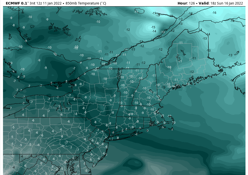
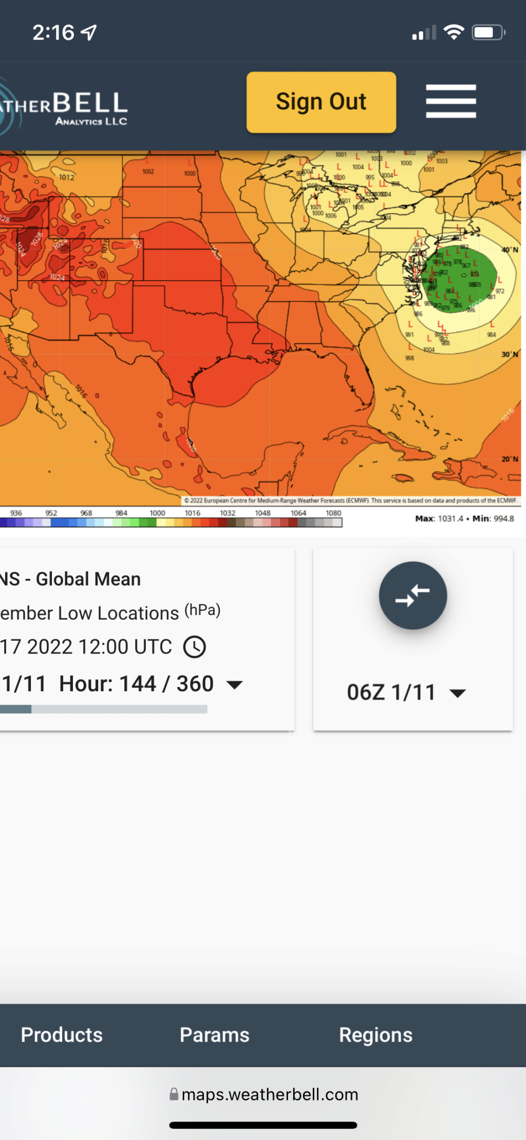
Momentum building for possible storm on JAN 16th?
Page 2 of 23 •  1, 2, 3 ... 12 ... 23
 Re: Momentum building for possible storm on JAN 16th?
lglickman1- Pro Enthusiast

- Posts : 319
Join date : 2013-02-05
rb924119 and essexcountypete like this post
 Re: Momentum building for possible storm on JAN 16th?
A long, long way to go with this one. Lot's of scenarios here.
CPcantmeasuresnow- Wx Statistician Guru

- Posts : 7274
Join date : 2013-01-07
rb924119 likes this post
 Re: Momentum building for possible storm on JAN 16th?
bobjohnsonforthehall wrote:If it phases with that trailing shortwave will that hold the storm back and make it run up through PA?
Very good question, as we are now seeing that become a greater possibility as well (the phasing). Unfortunately, it’s not east to answer haha it would definitely slow the storm down and extend the duration of the impacts. That much is certain. Aside from that, what I think we would see happen, is that it turn into more of a Miller-B, where the phase would force the initial low to cut up into West Virginia (or thereabouts), and then a secondary to form in response to the occlusion process somewhere over or near the Delmarva, at the triple point between the warm, cold and occluded fronts. Does this remind anybody of anything? Blizzard of January 2016. If we saw this phase occur, which is now becoming a clear possibility, I think we’d see a very similar evolution to the Blizzard of January 2016.
rb924119- Meteorologist

- Posts : 6928
Reputation : 194
Join date : 2013-02-06
Age : 32
Location : Greentown, Pa
phil155 likes this post
 Re: Momentum building for possible storm on JAN 16th?
dsix85 wrote:It made worth asking even though it was mentioned before, should we not be concerned about most of the area showing rain but rather more excited at the idea of a major system heading our way?
rb924119- Meteorologist

- Posts : 6928
Reputation : 194
Join date : 2013-02-06
Age : 32
Location : Greentown, Pa
 Re: Momentum building for possible storm on JAN 16th?
_________________
"In weather and in life, there's no winning and losing; there's only winning and learning."
WINTER 2012/2013 TOTALS 43.65"WINTER 2017/2018 TOTALS 62.85" WINTER 2022/2023 TOTALS 4.9"
WINTER 2013/2014 TOTALS 64.85"WINTER 2018/2019 TOTALS 14.25" WINTER 2023/2024 TOTALS 13.1"
WINTER 2014/2015 TOTALS 71.20"WINTER 2019/2020 TOTALS 6.35"
WINTER 2015/2016 TOTALS 35.00"WINTER 2020/2021 TOTALS 37.75"
WINTER 2016/2017 TOTALS 42.25"WINTER 2021/2022 TOTALS 31.65"

sroc4- Admin

- Posts : 8354
Reputation : 302
Join date : 2013-01-07
Location : Wading River, LI
rb924119 and Hardwaremike like this post
 Re: Momentum building for possible storm on JAN 16th?
rb924119 wrote:bobjohnsonforthehall wrote:If it phases with that trailing shortwave will that hold the storm back and make it run up through PA?
Very good question, as we are now seeing that become a greater possibility as well (the phasing). Unfortunately, it’s not east to answer haha it would definitely slow the storm down and extend the duration of the impacts. That much is certain. Aside from that, what I think we would see happen, is that it turn into more of a Miller-B, where the phase would force the initial low to cut up into West Virginia (or thereabouts), and then a secondary to form in response to the occlusion process somewhere over or near the Delmarva, at the triple point between the warm, cold and occluded fronts. Does this remind anybody of anything? Blizzard of January 2016. If we saw this phase occur, which is now becoming a clear possibility, I think we’d see a very similar evolution to the Blizzard of January 2016.
The blizzard of 96 had temperatures in the teens through most of the event, even down to the city. We certainly wouldn't have that, right?

CPcantmeasuresnow- Wx Statistician Guru

- Posts : 7274
Reputation : 230
Join date : 2013-01-07
Age : 103
Location : Eastern Orange County, NY
rb924119 likes this post
 Re: Momentum building for possible storm on JAN 16th?
bobjohnsonforthehall wrote:If it phases with that trailing shortwave will that hold the storm back and make it run up through PA?
If that happens then yes…the storms gets tugged west and we pretty much all rain. From the H5 map below the vort you’re talking about is the northern most circle. Our southern vort is the main low pressure. This energy actually closes off over Oklahoma which is pretty crazy. I don’t think that is right. Once this energy is better sampled, my guess is the ULL closes off further east. Which means your low center tracks more offshore.

dsix85 wrote:It made worth asking even though it was mentioned before, should we not be concerned about most of the area showing rain but rather more excited at the idea of a major system heading our way?
Seeing precipitation maps is pretty meaningless. Just have to look at what’s happening aloft. Without a doubt, things have changed drastically. I’m still sticking to my original probability %’s until at least tomorrow night.
_________________
_______________________________________________________________________________________________________
CLICK HERE to view NJ Strong Snowstorm Classifications
 Re: Momentum building for possible storm on JAN 16th?
CPcantmeasuresnow wrote:And now all the players are on board. Except we're now to far west. Who would have thought in 24 hours the changes would be that drastic on the models.
A long, long way to go with this one. Lot's of scenarios here.
“If you build it, they will come.” We built the pattern Cp
rb924119- Meteorologist

- Posts : 6928
Reputation : 194
Join date : 2013-02-06
Age : 32
Location : Greentown, Pa
CPcantmeasuresnow likes this post
 Re: Momentum building for possible storm on JAN 16th?
CPcantmeasuresnow wrote:And now all the players are on board. Except we're now to far west. Who would have thought in 24 hours the changes would be that drastic on the models.
A long, long way to go with this one. Lot's of scenarios here.
We would do very well on that run N and W although it's a little to close for comfort. Stunning changes between 00z and 12z on CMC and Euro.
hyde345- Pro Enthusiast

- Posts : 1082
Reputation : 48
Join date : 2013-01-08
Location : Hyde Park, NY
 Re: Momentum building for possible storm on JAN 16th?
_________________
_______________________________________________________________________________________________________
CLICK HERE to view NJ Strong Snowstorm Classifications
sroc4, CPcantmeasuresnow, rb924119, essexcountypete and Sparky Sparticles like this post
 Re: Momentum building for possible storm on JAN 16th?
Frank_Wx wrote:bobjohnsonforthehall wrote:If it phases with that trailing shortwave will that hold the storm back and make it run up through PA?
If that happens then yes…the storms gets tugged west and we pretty much all rain. From the H5 map below the vort you’re talking about is the northern most circle. Our southern vort is the main low pressure. This energy actually closes off over Oklahoma which is pretty crazy. I don’t think that is right. Once this energy is better sampled, my guess is the ULL closes off further east. Which means your low center tracks more offshore.dsix85 wrote:It made worth asking even though it was mentioned before, should we not be concerned about most of the area showing rain but rather more excited at the idea of a major system heading our way?
Seeing precipitation maps is pretty meaningless. Just have to look at what’s happening aloft. Without a doubt, things have changed drastically. I’m still sticking to my original probability %’s until at least tomorrow night.
Depends when/where it phases, Frank. If it doesn’t phase until it’s over the Mid-Atlantic, then yeah, we get warm sectors and central/northern New England get the goods. But if it phases over Kentucky, which another shift like we just saw and that’s where it will be, then you’re looking at January 2016 2.0 in my opinion.
rb924119- Meteorologist

- Posts : 6928
Reputation : 194
Join date : 2013-02-06
Age : 32
Location : Greentown, Pa
amugs likes this post
 Re: Momentum building for possible storm on JAN 16th?
CPcantmeasuresnow wrote:rb924119 wrote:bobjohnsonforthehall wrote:If it phases with that trailing shortwave will that hold the storm back and make it run up through PA?
Very good question, as we are now seeing that become a greater possibility as well (the phasing). Unfortunately, it’s not east to answer haha it would definitely slow the storm down and extend the duration of the impacts. That much is certain. Aside from that, what I think we would see happen, is that it turn into more of a Miller-B, where the phase would force the initial low to cut up into West Virginia (or thereabouts), and then a secondary to form in response to the occlusion process somewhere over or near the Delmarva, at the triple point between the warm, cold and occluded fronts. Does this remind anybody of anything? Blizzard of January 2016. If we saw this phase occur, which is now becoming a clear possibility, I think we’d see a very similar evolution to the Blizzard of January 2016.
The blizzard of 96 had temperatures in the teens through most of the event, even down to the city. We certainly wouldn't have that, right?
2016, Cp, not ‘96 lmao
rb924119- Meteorologist

- Posts : 6928
Reputation : 194
Join date : 2013-02-06
Age : 32
Location : Greentown, Pa
 Re: Momentum building for possible storm on JAN 16th?
heehaw453- Advanced Forecaster

- Posts : 3906
Reputation : 86
Join date : 2014-01-20
Location : Bedminster Township, PA Elevation 600' ASL
rb924119 likes this post
 Re: Momentum building for possible storm on JAN 16th?

crippo84- Posts : 383
Reputation : 20
Join date : 2013-11-07
Age : 40
Location : East Village, NYC
kalleg, rb924119, Grselig and heehaw453 like this post
 Re: Momentum building for possible storm on JAN 16th?
CPcantmeasuresnow wrote:rb924119 wrote:bobjohnsonforthehall wrote:If it phases with that trailing shortwave will that hold the storm back and make it run up through PA?
Very good question, as we are now seeing that become a greater possibility as well (the phasing). Unfortunately, it’s not east to answer haha it would definitely slow the storm down and extend the duration of the impacts. That much is certain. Aside from that, what I think we would see happen, is that it turn into more of a Miller-B, where the phase would force the initial low to cut up into West Virginia (or thereabouts), and then a secondary to form in response to the occlusion process somewhere over or near the Delmarva, at the triple point between the warm, cold and occluded fronts. Does this remind anybody of anything? Blizzard of January 2016. If we saw this phase occur, which is now becoming a clear possibility, I think we’d see a very similar evolution to the Blizzard of January 2016.
The blizzard of 96 had temperatures in the teens through most of the event, even down to the city. We certainly wouldn't have that, right?
Blizzard of 96 was my favorite snow storm, I was living in jersey city at the time
phil155- Pro Enthusiast

- Posts : 483
Reputation : 4
Join date : 2019-12-16
Grselig, essexcountypete and heehaw453 like this post
 Re: Momentum building for possible storm on JAN 16th?

nutleyblizzard- Senior Enthusiast

- Posts : 1954
Reputation : 41
Join date : 2014-01-30
Age : 58
Location : Nutley, new jersey
rb924119, essexcountypete and heehaw453 like this post
heehaw453- Advanced Forecaster

- Posts : 3906
Reputation : 86
Join date : 2014-01-20
Location : Bedminster Township, PA Elevation 600' ASL
essexcountypete likes this post
 Re: Momentum building for possible storm on JAN 16th?
nutleyblizzard wrote:We’re still 6 days from the event which is an eternity for tracking a monster like this. My advice to everyone is to follow the ensembles for now. There’s going to be a lot of run to run variability with the OP’s which I fear will cause a lot of undue stress.
We all know that this a great, logical, clear-minded, and well thought out post. But what fun would there be in that????

rb924119- Meteorologist

- Posts : 6928
Reputation : 194
Join date : 2013-02-06
Age : 32
Location : Greentown, Pa
CPcantmeasuresnow, kalleg, Grselig, essexcountypete, heehaw453, Sparky Sparticles and phil155 like this post
 Re: Momentum building for possible storm on JAN 16th?
The key is that it isn’t too cold. It moderated enough on todays runs thanks to the forecasted height field evolution, but just little enough to not be too moderated. Again, I personally think that what we saw today was an over-correction. But we’ll see.
rb924119- Meteorologist

- Posts : 6928
Reputation : 194
Join date : 2013-02-06
Age : 32
Location : Greentown, Pa
heehaw453 likes this post

nutleyblizzard- Senior Enthusiast

- Posts : 1954
Reputation : 41
Join date : 2014-01-30
Age : 58
Location : Nutley, new jersey
 Re: Momentum building for possible storm on JAN 16th?
nutleyblizzard wrote:We’re still 6 days from the event which is an eternity for tracking a monster like this. My advice to everyone is to follow the ensembles for now. There’s going to be a lot of run to run variability with the OP’s which I fear will cause a lot of undue stress.
Good advice. Every single operational, CMC, Euro, UKIE, and GFS are showing something similar. It will be interesting to see the CMC and Euro ensembles.

hyde345- Pro Enthusiast

- Posts : 1082
Reputation : 48
Join date : 2013-01-08
Location : Hyde Park, NY

hyde345- Pro Enthusiast

- Posts : 1082
Reputation : 48
Join date : 2013-01-08
Location : Hyde Park, NY
rb924119 likes this post
rb924119- Meteorologist

- Posts : 6928
Reputation : 194
Join date : 2013-02-06
Age : 32
Location : Greentown, Pa
hyde345 likes this post
heehaw453- Advanced Forecaster

- Posts : 3906
Reputation : 86
Join date : 2014-01-20
Location : Bedminster Township, PA Elevation 600' ASL
rb924119 likes this post
 Re: Momentum building for possible storm on JAN 16th?

_________________
_______________________________________________________________________________________________________
CLICK HERE to view NJ Strong Snowstorm Classifications
Irish and Bwtr like this post
 Re: Momentum building for possible storm on JAN 16th?
By my eye it’s over Western Virginia and West Virginia in the ensemble mean. I expect this to shift further south/west as lead time decreases using my same ideas, and still like the Central Mid-Atlantic as the sweet spot. This is gonna be fun, as the January 2016 analog may be a good one.
rb924119- Meteorologist

- Posts : 6928
Reputation : 194
Join date : 2013-02-06
Age : 32
Location : Greentown, Pa
amugs likes this post

nutleyblizzard- Senior Enthusiast

- Posts : 1954
Reputation : 41
Join date : 2014-01-30
Age : 58
Location : Nutley, new jersey
Page 2 of 23 •  1, 2, 3 ... 12 ... 23
|
|
|

 Home
Home