
 Search
Momentum building for possible storm on JAN 16th?
Page 3 of 23 •  1, 2, 3, 4 ... 13 ... 23
 ![]()
Re: Momentum building for possible storm on JAN 16th?
![]() by rb924119 Tue Jan 11, 2022 2:25 pm
by rb924119 Tue Jan 11, 2022 2:25 pm
heehaw453 wrote:EPS has a lot of bombs. Like an unbelievable amount of bombs at D5+. It's getting phased early it would seem.

By my eye it’s over Western Virginia and West Virginia in the ensemble mean. I expect this to shift further south/west as lead time decreases using my same ideas, and still like the Central Mid-Atlantic as the sweet spot. This is gonna be fun, as the January 2016 analog may be a good one.
rb924119- Meteorologist

- Posts : 6928
Join date : 2013-02-06
amugs likes this post
Re: Momentum building for possible storm on JAN 16th?
![]() by nutleyblizzard Tue Jan 11, 2022 2:26 pm
by nutleyblizzard Tue Jan 11, 2022 2:26 pm
MEh. I still think this came too far west and will correct eastward in time. Models have often under modeled the strength of the NAO block. In the end I think this beast goes just inside the BM.rb924119 wrote:nutleyblizzard wrote:
Calm down everyone EPS is east.
Not really lol


nutleyblizzard- Senior Enthusiast

- Posts : 1954
Join date : 2014-01-30
Re: Momentum building for possible storm on JAN 16th?
![]() by rb924119 Tue Jan 11, 2022 2:30 pm
by rb924119 Tue Jan 11, 2022 2:30 pm
nutleyblizzard wrote:MEh. I still think this came too far west and will correct eastward in time. Models have often under modeled the strength of the NAO block. In the end I think this beast goes just inside the BM.rb924119 wrote:nutleyblizzard wrote:
Calm down everyone EPS is east.
Not really lol
I agree. As I have said, I think that this was an over-correction. But I think we see an overall shift southward of the evolution, not necessarily just eastward.
rb924119- Meteorologist
- Posts : 6928
Reputation : 194
Join date : 2013-02-06
Age : 32
Location : Greentown, Pa
Re: Momentum building for possible storm on JAN 16th?
![]() by hyde345 Tue Jan 11, 2022 2:31 pm
by hyde345 Tue Jan 11, 2022 2:31 pm
rb924119 wrote:heehaw453 wrote:EPS has a lot of bombs. Like an unbelievable amount of bombs at D5+. It's getting phased early it would seem.
By my eye it’s over Western Virginia and West Virginia in the ensemble mean. I expect this to shift further south/west as lead time decreases using my same ideas, and still like the Central Mid-Atlantic as the sweet spot. This is gonna be fun, as the January 2016 analog may be a good one.
I hope not. I got 3 flakes from that 2016 storm.

hyde345- Pro Enthusiast

- Posts : 1082
Reputation : 48
Join date : 2013-01-08
Location : Hyde Park, NY
Re: Momentum building for possible storm on JAN 16th?
![]() by Frank_Wx Tue Jan 11, 2022 2:32 pm
by Frank_Wx Tue Jan 11, 2022 2:32 pm
_________________
_______________________________________________________________________________________________________
CLICK HERE to view NJ Strong Snowstorm Classifications

Frank_Wx- Godzilla Seeker

- Posts : 21305
Reputation : 328
Join date : 2013-01-05
Age : 32
Location : Jersey City, NJ -

Re: Momentum building for possible storm on JAN 16th?
![]() by Frank_Wx Tue Jan 11, 2022 2:36 pm
by Frank_Wx Tue Jan 11, 2022 2:36 pm
_________________
_______________________________________________________________________________________________________
CLICK HERE to view NJ Strong Snowstorm Classifications
Frank_Wx- Godzilla Seeker
- Posts : 21305
Reputation : 328
Join date : 2013-01-05
Age : 32
Location : Jersey City, NJ -
Re: Momentum building for possible storm on JAN 16th?
![]() by rb924119 Tue Jan 11, 2022 2:39 pm
by rb924119 Tue Jan 11, 2022 2:39 pm
Frank_Wx wrote:Something I just noticed and don't really like - at least on the GFS - is how there is a High Pressure east of Maine. Between that and the east-based NAO block I fear that would give credence to a storm tracking up the coast or even slightly inland. Hmmm, will need to keep an eye on that feature.
Without the secondary phase, this is a valid concern if these northern tracks are legitimate. But if we get that secondary phase, then I wouldn’t worry too much about it. That secondary phase would be your injection of fresh cold air, as that is a direct Arctic discharge into the backside of our storm. Baby go boom lol
rb924119- Meteorologist
- Posts : 6928
Reputation : 194
Join date : 2013-02-06
Age : 32
Location : Greentown, Pa
Re: Momentum building for possible storm on JAN 16th?
![]() by nutleyblizzard Tue Jan 11, 2022 2:40 pm
by nutleyblizzard Tue Jan 11, 2022 2:40 pm
RB who knows at this point. We’re in a pattern that’s very convoluted with a lot of moving parts. Our line of thinking may blow up in our face and the storm heads for Philly ala March of 93. That’s why I love this hobby. Man it’s going to be a long sleepless week ahead.rb924119 wrote:nutleyblizzard wrote:MEh. I still think this came too far west and will correct eastward in time. Models have often under modeled the strength of the NAO block. In the end I think this beast goes just inside the BM.rb924119 wrote:nutleyblizzard wrote:
Calm down everyone EPS is east.
Not really lol
I agree. As I have said, I think that this was an over-correction. But I think we see an overall shift southward of the evolution, not necessarily just eastward.

nutleyblizzard- Senior Enthusiast
- Posts : 1954
Reputation : 41
Join date : 2014-01-30
Age : 58
Location : Nutley, new jersey
rb924119 and SENJsnowman like this post
Re: Momentum building for possible storm on JAN 16th?
![]() by rb924119 Tue Jan 11, 2022 2:52 pm
by rb924119 Tue Jan 11, 2022 2:52 pm

Seems I’m not the only one drawing this comparison. His son is in my camp, Joe thinks this is more like March ‘94. Not familiar with March ‘94, so maybe others can comment.
rb924119- Meteorologist
- Posts : 6928
Reputation : 194
Join date : 2013-02-06
Age : 32
Location : Greentown, Pa
phil155 likes this post
Re: Momentum building for possible storm on JAN 16th?
![]() by essexcountypete Tue Jan 11, 2022 3:03 pm
by essexcountypete Tue Jan 11, 2022 3:03 pm
rb924119 wrote:nutleyblizzard wrote:We’re still 6 days from the event which is an eternity for tracking a monster like this. My advice to everyone is to follow the ensembles for now. There’s going to be a lot of run to run variability with the OP’s which I fear will cause a lot of undue stress.
We all know that this a great, logical, clear-minded, and well thought out post. But what fun would there be in that????

So what you're saying is that it's perfectly normal that I've already refreshed this topic a dozen times today?
Some of us just like that feeling of the windshield wiper whacking us on the way by. It reminds us we're alive and tracking.

essexcountypete- Pro Enthusiast
- Posts : 783
Reputation : 12
Join date : 2013-12-09
Location : Bloomfield, NJ
kalleg, rb924119, SENJsnowman and Irish like this post
Re: Momentum building for possible storm on JAN 16th?
![]() by rb924119 Tue Jan 11, 2022 3:14 pm
by rb924119 Tue Jan 11, 2022 3:14 pm
essexcountypete wrote:rb924119 wrote:nutleyblizzard wrote:We’re still 6 days from the event which is an eternity for tracking a monster like this. My advice to everyone is to follow the ensembles for now. There’s going to be a lot of run to run variability with the OP’s which I fear will cause a lot of undue stress.
We all know that this a great, logical, clear-minded, and well thought out post. But what fun would there be in that????
So what you're saying is that it's perfectly normal that I've already refreshed this topic a dozen times today?
Some of us just like that feeling of the windshield wiper whacking us on the way by. It reminds us we're alive and tracking.
COMPLETELY normal. I can’t believe you’ve only done it a dozen times - I’m on about 40 lmaooo and, considering that this thread is only three pages long and already has 1240 views, I think it’s safe to assume that we aren’t alone hahaha
Your second comment is too funny ahaha funny because it’s so true.
rb924119- Meteorologist
- Posts : 6928
Reputation : 194
Join date : 2013-02-06
Age : 32
Location : Greentown, Pa
essexcountypete likes this post
Re: Momentum building for possible storm on JAN 16th?
![]() by bobjohnsonforthehall Tue Jan 11, 2022 3:17 pm
by bobjohnsonforthehall Tue Jan 11, 2022 3:17 pm
essexcountypete wrote:rb924119 wrote:nutleyblizzard wrote:We’re still 6 days from the event which is an eternity for tracking a monster like this. My advice to everyone is to follow the ensembles for now. There’s going to be a lot of run to run variability with the OP’s which I fear will cause a lot of undue stress.
We all know that this a great, logical, clear-minded, and well thought out post. But what fun would there be in that????
So what you're saying is that it's perfectly normal that I've already refreshed this topic a dozen times today?
Some of us just like that feeling of the windshield wiper whacking us on the way by. It reminds us we're alive and tracking.

Ride that wiper. EEEYYYAAAHHHH

bobjohnsonforthehall- Posts : 311
Reputation : 19
Join date : 2016-10-02
Location : Flemington NJ
kalleg, rb924119 and essexcountypete like this post
Re: Momentum building for possible storm on JAN 16th?
![]() by mikeypizano Tue Jan 11, 2022 3:21 pm
by mikeypizano Tue Jan 11, 2022 3:21 pm

mikeypizano- Pro Enthusiast
- Posts : 1118
Reputation : 66
Join date : 2017-01-05
Age : 35
Location : Wilkes-Barre/Scranton, PA
rb924119 likes this post
Re: Momentum building for possible storm on JAN 16th?
![]() by Grselig Tue Jan 11, 2022 3:30 pm
by Grselig Tue Jan 11, 2022 3:30 pm
bobjohnsonforthehall wrote:essexcountypete wrote:rb924119 wrote:nutleyblizzard wrote:We’re still 6 days from the event which is an eternity for tracking a monster like this. My advice to everyone is to follow the ensembles for now. There’s going to be a lot of run to run variability with the OP’s which I fear will cause a lot of undue stress.
We all know that this a great, logical, clear-minded, and well thought out post. But what fun would there be in that????
So what you're saying is that it's perfectly normal that I've already refreshed this topic a dozen times today?
Some of us just like that feeling of the windshield wiper whacking us on the way by. It reminds us we're alive and tracking.
Ride that wiper. EEEYYYAAAHHHH
Its a disease! The only cure is more snow!

Grselig- Senior Enthusiast
- Posts : 1408
Reputation : 140
Join date : 2013-03-04
Age : 54
Location : Wayne NJ
CPcantmeasuresnow, rb924119 and essexcountypete like this post
Re: Momentum building for possible storm on JAN 16th?
![]() by nutleyblizzard Tue Jan 11, 2022 3:47 pm
by nutleyblizzard Tue Jan 11, 2022 3:47 pm
nutleyblizzard- Senior Enthusiast
- Posts : 1954
Reputation : 41
Join date : 2014-01-30
Age : 58
Location : Nutley, new jersey
Re: Momentum building for possible storm on JAN 16th?
![]() by heehaw453 Tue Jan 11, 2022 4:07 pm
by heehaw453 Tue Jan 11, 2022 4:07 pm
rb924119 wrote:Frank_Wx wrote:Something I just noticed and don't really like - at least on the GFS - is how there is a High Pressure east of Maine. Between that and the east-based NAO block I fear that would give credence to a storm tracking up the coast or even slightly inland. Hmmm, will need to keep an eye on that feature.
Without the secondary phase, this is a valid concern if these northern tracks are legitimate. But if we get that secondary phase, then I wouldn’t worry too much about it. That secondary phase would be your injection of fresh cold air, as that is a direct Arctic discharge into the backside of our storm. Baby go boom lol
Yeah pinwheeled right off the TPV lobe over Hudson Bay.
heehaw453- Advanced Forecaster

- Posts : 3906
Reputation : 86
Join date : 2014-01-20
Location : Bedminster Township, PA Elevation 600' ASL
rb924119 likes this post
Re: Momentum building for possible storm on JAN 16th?
![]() by Irish Tue Jan 11, 2022 4:14 pm
by Irish Tue Jan 11, 2022 4:14 pm

Irish- Pro Enthusiast
- Posts : 788
Reputation : 19
Join date : 2019-01-16
Age : 45
Location : Old Bridge, NJ
rb924119 and heehaw453 like this post
Re: Momentum building for possible storm on JAN 16th?
![]() by CPcantmeasuresnow Tue Jan 11, 2022 4:18 pm
by CPcantmeasuresnow Tue Jan 11, 2022 4:18 pm
Grselig wrote:bobjohnsonforthehall wrote:essexcountypete wrote:rb924119 wrote:nutleyblizzard wrote:We’re still 6 days from the event which is an eternity for tracking a monster like this. My advice to everyone is to follow the ensembles for now. There’s going to be a lot of run to run variability with the OP’s which I fear will cause a lot of undue stress.
We all know that this a great, logical, clear-minded, and well thought out post. But what fun would there be in that????
So what you're saying is that it's perfectly normal that I've already refreshed this topic a dozen times today?
Some of us just like that feeling of the windshield wiper whacking us on the way by. It reminds us we're alive and tracking.
Ride that wiper. EEEYYYAAAHHHH
Its a disease! The only cure is more snow!
Except it's not even a cure, it's just a drug to treat the symptoms. But several days after the storm you need more, or all the symptoms return, whining, depression, insomnia etc.

CPcantmeasuresnow- Wx Statistician Guru

- Posts : 7274
Reputation : 230
Join date : 2013-01-07
Age : 103
Location : Eastern Orange County, NY
rb924119, Grselig, essexcountypete and heehaw453 like this post
Re: Momentum building for possible storm on JAN 16th?
![]() by amugs Tue Jan 11, 2022 4:47 pm
by amugs Tue Jan 11, 2022 4:47 pm
March 2-3 was an good storm to the NYC Metro and coastal regions. Move this 100 miles SE and its a banger, it was March this is the heart of Jan.
STORM DESCRIPTION
A powerful nor'easter brought two days of rain, sleet, snow, high winds, coastal flooding and beach erosion to New Jersey.
Synoptic Discussion
The storm system developed along the Front Range of the Rockies on February 27th. It sank southward into western Texas on February 28th, moved eastward to Louisiana on March 1st, and reached South Carolina on the 2nd. It then turned northeastward, strengthening rapidly as it reached the Delmarva peninsula early on the 3rd. The storm continued moving northeastward but only strengthened a little more, reaching Nova Scotia early on the 4th.
Local Discussion
Precipitation slowly overspread the state from south to north during the day on the 2nd, becoming heavy at times several hours after beginning. Across the south, precipitation that began in the form of snow changed to sleet and then rain by midday on the 2nd as warm air moved northward both at the surface and aloft. Further north, precipitation gradually mixed with and changed to sleet and rain across central New Jersey during the night of the 2nd. Across northern New Jersey, precipitation mixed with sleet, but generally remained in frozen form for the duration of the storm. Precipitation intensity decreased significantly overnight on the 2nd and continued at a very light rate for most of the 3rd. The rain and drizzle across southern and central New Jersey and the sleet and drizzle across northern New Jersey briefly mixed with snow before ending during the evening of the 3rd as cold air wrapped back across the state in the storm's wake. Accumulations were highest across the northwest, where they averaged from 8 to 16 inches. Across northeastern and central New Jersey, accumulations ranged from 5 to 8 inches, while across east-central and southern New Jersey, accumulations were mainly on the order of a coating to 4 inches. The storm also caused wind gusts in excess of 60 mph, especially along the coast, which in turn resulted in significant beach erosion and mostly minor coastal flooding.


_________________
Mugs
AKA:King: Snow Weenie
Self Proclaimed
WINTER 2014-15 : 55.12" +.02 for 6 coatings (avg. 35")
WINTER 2015-16 Total - 29.8" (Avg 35")
WINTER 2016-17 : 39.5" so far

amugs- Advanced Forecaster - Mod

- Posts : 15095
Reputation : 213
Join date : 2013-01-07
Age : 54
Location : Hillsdale,NJ
rb924119 likes this post
Re: Momentum building for possible storm on JAN 16th?
![]() by amugs Tue Jan 11, 2022 4:54 pm
by amugs Tue Jan 11, 2022 4:54 pm
There is a quantum amout of time, 12 more cycle model runs and we see with these bigger storms that they are here, gone tomorrow, correct left, right and settle in. The energy is not in well samples areas and won't be until Thursday so make the popcorn and hang tight.
NAM just brought Fridays storm closer to the coast and LI. Just saying....
_________________
Mugs
AKA:King: Snow Weenie
Self Proclaimed
WINTER 2014-15 : 55.12" +.02 for 6 coatings (avg. 35")
WINTER 2015-16 Total - 29.8" (Avg 35")
WINTER 2016-17 : 39.5" so far
amugs- Advanced Forecaster - Mod
- Posts : 15095
Reputation : 213
Join date : 2013-01-07
Age : 54
Location : Hillsdale,NJ
rb924119 likes this post
Re: Momentum building for possible storm on JAN 16th?
![]() by amugs Tue Jan 11, 2022 4:58 pm
by amugs Tue Jan 11, 2022 4:58 pm
I see a couple of scenarios that work for us.
1) We get a powerful, phased shortwave entering the US along the downstream side of the PNA ridge really far back west that amplifies and cuts itself off quickly, but while also having the ocean storm more phased into the TPV, allowing a perfect combination of beastly shortwave and confluence. This would result in a blizzard on Sunday night into Monday.
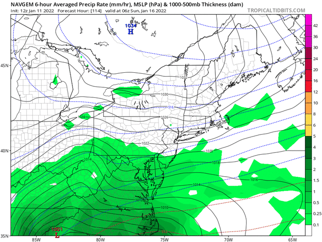
2) We get a phased shortwave entering the US along the downstream side of the PNA ridge, but it's more progressive initially -- progressive and phased like the 12z NAVGEM. This way you still get downstream height rises but it does not cut itself off (or cuts off very late). This allows for a faster solution that coincides with when the TPV lobe is still in Southeast Canada. This would result in a blizzard on Sunday.
Perhaps scenario 2.5 like the UKMET, increased phasing with the ocean storm allows confluence to linger long enough for our storm to cut itself off but gain latitude a lot slower while it waits for a phase
_________________
Mugs
AKA:King: Snow Weenie
Self Proclaimed
WINTER 2014-15 : 55.12" +.02 for 6 coatings (avg. 35")
WINTER 2015-16 Total - 29.8" (Avg 35")
WINTER 2016-17 : 39.5" so far
amugs- Advanced Forecaster - Mod
- Posts : 15095
Reputation : 213
Join date : 2013-01-07
Age : 54
Location : Hillsdale,NJ
rb924119 likes this post
Re: Momentum building for possible storm on JAN 16th?
![]() by rb924119 Tue Jan 11, 2022 5:05 pm
by rb924119 Tue Jan 11, 2022 5:05 pm
I expect 18z GFS to show a more amplified solution based on its presentation through 84. 18z Op run, so just have fun lol
rb924119- Meteorologist
- Posts : 6928
Reputation : 194
Join date : 2013-02-06
Age : 32
Location : Greentown, Pa
Re: Momentum building for possible storm on JAN 16th?
![]() by rb924119 Tue Jan 11, 2022 5:15 pm
by rb924119 Tue Jan 11, 2022 5:15 pm
rb924119- Meteorologist
- Posts : 6928
Reputation : 194
Join date : 2013-02-06
Age : 32
Location : Greentown, Pa
heehaw453 likes this post
Re: Momentum building for possible storm on JAN 16th?
![]() by amugs Tue Jan 11, 2022 6:10 pm
by amugs Tue Jan 11, 2022 6:10 pm

_________________
Mugs
AKA:King: Snow Weenie
Self Proclaimed
WINTER 2014-15 : 55.12" +.02 for 6 coatings (avg. 35")
WINTER 2015-16 Total - 29.8" (Avg 35")
WINTER 2016-17 : 39.5" so far
amugs- Advanced Forecaster - Mod
- Posts : 15095
Reputation : 213
Join date : 2013-01-07
Age : 54
Location : Hillsdale,NJ
jmanley32 and SENJsnowman like this post
Re: Momentum building for possible storm on JAN 16th?
![]() by jmanley32 Tue Jan 11, 2022 6:53 pm
by jmanley32 Tue Jan 11, 2022 6:53 pm

jmanley32- Senior Enthusiast
- Posts : 20535
Reputation : 108
Join date : 2013-12-12
Age : 43
Location : Yonkers, NY
Re: Momentum building for possible storm on JAN 16th?
![]() by jmanley32 Tue Jan 11, 2022 6:55 pm
by jmanley32 Tue Jan 11, 2022 6:55 pm
Compared to less than a day ago when models showed a storm completely missing?amugs wrote:GEFS are beautiful IMO
jmanley32- Senior Enthusiast
- Posts : 20535
Reputation : 108
Join date : 2013-12-12
Age : 43
Location : Yonkers, NY
Re: Momentum building for possible storm on JAN 16th?
![]() by Irish Tue Jan 11, 2022 7:37 pm
by Irish Tue Jan 11, 2022 7:37 pm
jmanley32 wrote:I've seen huge jumps west today the word Madonne from Frank and rb..can I get a little excited? I remember January 2016 well. Got obliterated like 28 inches!!
No, do your best to hold back on any real true excitement because the letdown is just awful. We wait and anticipation builds...
Irish- Pro Enthusiast
- Posts : 788
Reputation : 19
Join date : 2019-01-16
Age : 45
Location : Old Bridge, NJ
Page 3 of 23 • 1, 2, 3, 4 ... 13 ... 23 ![]()
|
|
|