
 Search
Long Range Discussion 23.0
Page 6 of 26 •  1 ... 5, 6, 7 ... 16 ... 26
 ![]()
Re: Long Range Discussion 23.0
![]() by amugs Mon Jan 24, 2022 6:54 am
by amugs Mon Jan 24, 2022 6:54 am
.And Frank u listening not ticker tape or storm mode until we are within 18 hours!!!! That has been the jinx all winter!!sroc4 wrote:CPcantmeasuresnow wrote:I don’t want to jinx it but this may need a storm thread, for this weekend. Things got very interesting over night on all the 0Z runs. REALLY INTERESTING!!!!!!
NO SEPARATE THREAD YET!!! It’s the KOD. This season at least.
Grand Planetary Gravity Wave on the Globe with this. Last time we saw this.....March Superstorm 1993!

amugs- Advanced Forecaster - Mod

- Posts : 15095
Join date : 2013-01-07
MattyICE likes this post
Re: Long Range Discussion 23.0
![]() by Radz Mon Jan 24, 2022 6:59 am
by Radz Mon Jan 24, 2022 6:59 am
Radz- Pro Enthusiast

- Posts : 1028
Join date : 2013-01-12
Re: Long Range Discussion 23.0
![]() by jmanley32 Mon Jan 24, 2022 7:10 am
by jmanley32 Mon Jan 24, 2022 7:10 am
Heh yeah was nice to wake and see those runs plenty of time to be all over the place east west will be interesting week. I'm still not biting because a storm like the cmc and some gfs runs are rather u usual. I hope continues to show this come wed Thurs.Radz wrote:I know 5 days is a lifetime away, but the solutions being spit out are giving me chills lol - reel her in!

jmanley32- Senior Enthusiast

- Posts : 20535
Reputation : 108
Join date : 2013-12-12
Age : 43
Location : Yonkers, NY
SENJsnowman likes this post
Re: Long Range Discussion 23.0
![]() by dsix85 Mon Jan 24, 2022 7:10 am
by dsix85 Mon Jan 24, 2022 7:10 am
dsix85- Pro Enthusiast
- Posts : 349
Reputation : 8
Join date : 2014-01-01
Location : New York
jmanley32, Irish and phil155 like this post
Re: Long Range Discussion 23.0
![]() by heehaw453 Mon Jan 24, 2022 7:44 am
by heehaw453 Mon Jan 24, 2022 7:44 am

heehaw453- Advanced Forecaster

- Posts : 3906
Reputation : 86
Join date : 2014-01-20
Location : Bedminster Township, PA Elevation 600' ASL
Re: Long Range Discussion 23.0
![]() by nutleyblizzard Mon Jan 24, 2022 7:55 am
by nutleyblizzard Mon Jan 24, 2022 7:55 am
Massive improvements overnight at H5 with the models. What ever happened to the kicker which was supposed to flatten out the ridge and is there still a threat of it returning?heehaw453 wrote:The 06Z GFS went in on the possibility of the storm directly impacting the area. The ULL is getting pulled NNE and this would be a bomb well inside the BM. It would actually try to reconsolidate further north. Synoptically we have an excellent ridge, vigorous n/s s/w diving into the gulf and if energy is not left back we at least have a chance. We have an east based ridge and this storm may get pinched between the backend trough and the Atlantic ridge. Buckle up it's going to be a bumpy ride until Saturday.

nutleyblizzard- Senior Enthusiast
- Posts : 1954
Reputation : 41
Join date : 2014-01-30
Age : 58
Location : Nutley, new jersey
Re: Long Range Discussion 23.0
![]() by heehaw453 Mon Jan 24, 2022 8:07 am
by heehaw453 Mon Jan 24, 2022 8:07 am

heehaw453- Advanced Forecaster
- Posts : 3906
Reputation : 86
Join date : 2014-01-20
Location : Bedminster Township, PA Elevation 600' ASL
amugs likes this post
Re: Long Range Discussion 23.0
![]() by dsix85 Mon Jan 24, 2022 8:10 am
by dsix85 Mon Jan 24, 2022 8:10 am
dsix85- Pro Enthusiast
- Posts : 349
Reputation : 8
Join date : 2014-01-01
Location : New York
Re: Long Range Discussion 23.0
![]() by jmanley32 Mon Jan 24, 2022 8:12 am
by jmanley32 Mon Jan 24, 2022 8:12 am
So has your confidence in it being a miss gone down at all? Or still to early to tell? The fact that the models at least some what agree as of over noight and this morning IMO is a good sign but what are the chances such as stated above the kicker comes back and that pinch in the ridge disappears? Oy what a week this is going to be, at least I have my hectic schedule to keep me busy. This would be saturday, or Friday?heehaw453 wrote:This 06Z GFS H5 is similar to Canadian. The storm gets pinched between the ridges with excellent consolidation. The GFS actually shows the Atlantic ridge strengthening as the storm approaches and I think that is going to be a big factor in the storm trajectory.
jmanley32- Senior Enthusiast
- Posts : 20535
Reputation : 108
Join date : 2013-12-12
Age : 43
Location : Yonkers, NY
Re: Long Range Discussion 23.0
![]() by jmanley32 Mon Jan 24, 2022 8:13 am
by jmanley32 Mon Jan 24, 2022 8:13 am
that would be insane if so, and yeah it looks to be a slow mover if pieces fall as shown, which we have to be careful about on day 4-5 out. Also look at the winds, this would be my dream storm, rediculously heavy snow and 50-60mph wind gusts. Yes I am fully aware this could still be a miss I am not getting hyped just hopinh.dsix85 wrote:@heehaw…does a storm like this have the opportunity to have impacts beyond a 24 hour window? Looks like this would be drawn out over a full day, correct?
jmanley32- Senior Enthusiast
- Posts : 20535
Reputation : 108
Join date : 2013-12-12
Age : 43
Location : Yonkers, NY
Re: Long Range Discussion 23.0
![]() by heehaw453 Mon Jan 24, 2022 8:15 am
by heehaw453 Mon Jan 24, 2022 8:15 am
dsix85 wrote:@heehaw…does a storm like this have the opportunity to have impacts beyond a 24 hour window? Looks like this would be drawn out over a full day, correct?
If an ULL closes off there is that possibility. With amplification like that established it becomes meridional (n/s) and not progressive (e/w). The flow slows down because of that.
heehaw453- Advanced Forecaster
- Posts : 3906
Reputation : 86
Join date : 2014-01-20
Location : Bedminster Township, PA Elevation 600' ASL
Re: Long Range Discussion 23.0
![]() by heehaw453 Mon Jan 24, 2022 8:17 am
by heehaw453 Mon Jan 24, 2022 8:17 am
jmanley32 wrote:So has your confidence in it being a miss gone down at all? Or still to early to tell? The fact that the models at least some what agree as of over noight and this morning IMO is a good sign but what are the chances such as stated above the kicker comes back and that pinch in the ridge disappears? Oy what a week this is going to be, at least I have my hectic schedule to keep me busy. This would be saturday, or Friday?heehaw453 wrote:This 06Z GFS H5 is similar to Canadian. The storm gets pinched between the ridges with excellent consolidation. The GFS actually shows the Atlantic ridge strengthening as the storm approaches and I think that is going to be a big factor in the storm trajectory.
I have no confidence in any details ATTM, but if the H5 is correct, then I think it's more likely than not that it won't go OTS. Direct impact? Way to early to know that yet. That to me depends on consolidation/phasing, but some ingredients are there...
heehaw453- Advanced Forecaster
- Posts : 3906
Reputation : 86
Join date : 2014-01-20
Location : Bedminster Township, PA Elevation 600' ASL
Judy Margolis and phil155 like this post
Re: Long Range Discussion 23.0
![]() by amugs Mon Jan 24, 2022 8:37 am
by amugs Mon Jan 24, 2022 8:37 am
If we can get teh block to push a tad more westward we'd slow up the flow more but I like that the East Based NAO is pinched westward and deepening. WE also have Wednesday's storm miss that may just help slow teh flow as well a bit.
IF we ha d a solid west based NAO this would be a HECS to on the verge of BECS as depicted on all models - playing the iF game here i know. More to come of course in the next 4 days
_________________
Mugs
AKA:King: Snow Weenie
Self Proclaimed
WINTER 2014-15 : 55.12" +.02 for 6 coatings (avg. 35")
WINTER 2015-16 Total - 29.8" (Avg 35")
WINTER 2016-17 : 39.5" so far

amugs- Advanced Forecaster - Mod
- Posts : 15095
Reputation : 213
Join date : 2013-01-07
Age : 54
Location : Hillsdale,NJ
Snow88 likes this post
Re: Long Range Discussion 23.0
![]() by CPcantmeasuresnow Mon Jan 24, 2022 8:46 am
by CPcantmeasuresnow Mon Jan 24, 2022 8:46 am
Yes I know snow maps aren't very helpful but it's all I've got.


CPcantmeasuresnow- Wx Statistician Guru

- Posts : 7274
Reputation : 230
Join date : 2013-01-07
Age : 103
Location : Eastern Orange County, NY
Re: Long Range Discussion 23.0
![]() by Frank_Wx Mon Jan 24, 2022 8:53 am
by Frank_Wx Mon Jan 24, 2022 8:53 am

This is the precise trend you want to see. A slower/deeper short wave off the west coast which allows a stronger/more poleward western ridge. This greatly enhances the snow probability along the east coast this weekend.
Can’t get excited yet. There’s still some work to do. And whose to say these trends don’t trend unfavorable over the next two days (as has been the case all season long)? Temper excitement and hope the positive trends continue!
_________________
_______________________________________________________________________________________________________
CLICK HERE to view NJ Strong Snowstorm Classifications

Frank_Wx- Godzilla Seeker

- Posts : 21305
Reputation : 328
Join date : 2013-01-05
Age : 32
Location : Jersey City, NJ -

amugs and mmanisca like this post
Re: Long Range Discussion 23.0
![]() by amugs Mon Jan 24, 2022 9:12 am
by amugs Mon Jan 24, 2022 9:12 am
@Hee Haw great work in this thread for this storm
Last four runs of the ECMWF EPS valid 12z Saturday. Get comfortable, kids!! pic.twitter.com/OJb3NPZIq4
— John Homenuk (@jhomenuk) January 24, 2022
_________________
Mugs
AKA:King: Snow Weenie
Self Proclaimed
WINTER 2014-15 : 55.12" +.02 for 6 coatings (avg. 35")
WINTER 2015-16 Total - 29.8" (Avg 35")
WINTER 2016-17 : 39.5" so far
amugs- Advanced Forecaster - Mod
- Posts : 15095
Reputation : 213
Join date : 2013-01-07
Age : 54
Location : Hillsdale,NJ
Re: Long Range Discussion 23.0
![]() by SENJsnowman Mon Jan 24, 2022 9:59 am
by SENJsnowman Mon Jan 24, 2022 9:59 am
CPcantmeasuresnow wrote:Canadian snowfall map from last night and the GFS this morning. Both very similar and pretty confident both will chnage one way or the other over the next 5 days. Eerily similar those this far out, though, especially how they both show mostly rain in eastern Mass and RI. The GFS had a similar snow map 4 days ago then lost it for several days.
Yes I know snow maps aren't very helpful but it's all I've got.
Yep yep yep. This is the point that I go all in. I know the risks, and I know how to keep my ‘mush’ mouth shut so as to not ruin anything for anyone else. But the thrill is in the hunt, and I’m on the hunt. So, the thrill is on!
And thanks so much to everyone for all the updates. Heehaw you are simply tireless my brother, thank you for the constant updates and analyis!!
SENJsnowman- Senior Enthusiast
- Posts : 1189
Reputation : 61
Join date : 2017-01-06
Age : 51
Location : Bayville, NJ
CPcantmeasuresnow, Irish and phil155 like this post
Re: Long Range Discussion 23.0
![]() by phil155 Mon Jan 24, 2022 10:08 am
by phil155 Mon Jan 24, 2022 10:08 am
SENJsnowman wrote:CPcantmeasuresnow wrote:Canadian snowfall map from last night and the GFS this morning. Both very similar and pretty confident both will chnage one way or the other over the next 5 days. Eerily similar those this far out, though, especially how they both show mostly rain in eastern Mass and RI. The GFS had a similar snow map 4 days ago then lost it for several days.
Yes I know snow maps aren't very helpful but it's all I've got.
Yep yep yep. This is the point that I go all in. I know the risks, and I know how to keep my ‘mush’ mouth shut so as to not ruin anything for anyone else. But the thrill is in the hunt, and I’m on the hunt. So, the thrill is on!
And thanks so much to everyone for all the updates. Heehaw you are simply tireless my brother, thank you for the constant updates and analyis!!
I like the early commitment, I like it
Last edited by phil155 on Mon Jan 24, 2022 10:09 am; edited 1 time in total
phil155- Pro Enthusiast
- Posts : 483
Reputation : 4
Join date : 2019-12-16
SENJsnowman likes this post
Re: Long Range Discussion 23.0
![]() by CPcantmeasuresnow Mon Jan 24, 2022 10:08 am
by CPcantmeasuresnow Mon Jan 24, 2022 10:08 am
CPcantmeasuresnow wrote:Canadian snowfall map from last night and the GFS this morning. Both very similar and pretty confident both will chnage one way or the other over the next 5 days. Eerily similar those this far out, though, especially how they both show mostly rain in eastern Mass and RI. The GFS had a similar snow map 4 days ago then lost it for several days.
Yes I know snow maps aren't very helpful but it's all I've got.
Throw the EPS mean from this morning showing 8-10 through most of the forum and 10-12 on LI and CT. It doesn't have the rain in eastern New England like this mornings GFS and last nights Canadian, thus we assume a little more eastern track. Three models all with decent hits, yet as all of our experts have pointed out so much still has to come together for this to work. I'd say I'll look again Wednesday to see what's going on before I get too pumped but I know I'll be checking the 12Z's in an hour.

Last edited by CPcantmeasuresnow on Mon Jan 24, 2022 10:51 am; edited 1 time in total
CPcantmeasuresnow- Wx Statistician Guru
- Posts : 7274
Reputation : 230
Join date : 2013-01-07
Age : 103
Location : Eastern Orange County, NY
Re: Long Range Discussion 23.0
![]() by Frank_Wx Mon Jan 24, 2022 10:29 am
by Frank_Wx Mon Jan 24, 2022 10:29 am

_________________
_______________________________________________________________________________________________________
CLICK HERE to view NJ Strong Snowstorm Classifications
Frank_Wx- Godzilla Seeker
- Posts : 21305
Reputation : 328
Join date : 2013-01-05
Age : 32
Location : Jersey City, NJ -
dolphins222, Judy Margolis and phil155 like this post
Re: Long Range Discussion 23.0
![]() by amugs Mon Jan 24, 2022 10:55 am
by amugs Mon Jan 24, 2022 10:55 am

GFS rolling and it looks better through 51 if you can imagine
_________________
Mugs
AKA:King: Snow Weenie
Self Proclaimed
WINTER 2014-15 : 55.12" +.02 for 6 coatings (avg. 35")
WINTER 2015-16 Total - 29.8" (Avg 35")
WINTER 2016-17 : 39.5" so far
amugs- Advanced Forecaster - Mod
- Posts : 15095
Reputation : 213
Join date : 2013-01-07
Age : 54
Location : Hillsdale,NJ
Re: Long Range Discussion 23.0
![]() by hurrysundown23 Mon Jan 24, 2022 11:01 am
by hurrysundown23 Mon Jan 24, 2022 11:01 am
Fri 28 | Night
25°
79%
NNE 14 mph
Periods of snow. Low near 25F. Winds NNE at 10 to 20 mph. Chance of snow 80%. 3 to 5 inches of snow expected.
Humidity
74%
UV Index
0 of 10
Moonrise
3:51 am
Waning Crescent
Moonset
1:10 pm
Sat 29
29°
/13°
Snow
71%
NNW 18 mph
Sat 29 | Day
29°
71%
NNW 18 mph
Snow during the morning will transition to snow showers during the afternoon. High 29F. Winds NNW at 15 to 25 mph. Chance of snow 70%. 1 to 3 inches of snow expected.
hurrysundown23- Posts : 53
Reputation : 1
Join date : 2017-01-04
Location : Sayreville, NJ
Re: Long Range Discussion 23.0
![]() by MattyICE Mon Jan 24, 2022 11:07 am
by MattyICE Mon Jan 24, 2022 11:07 am
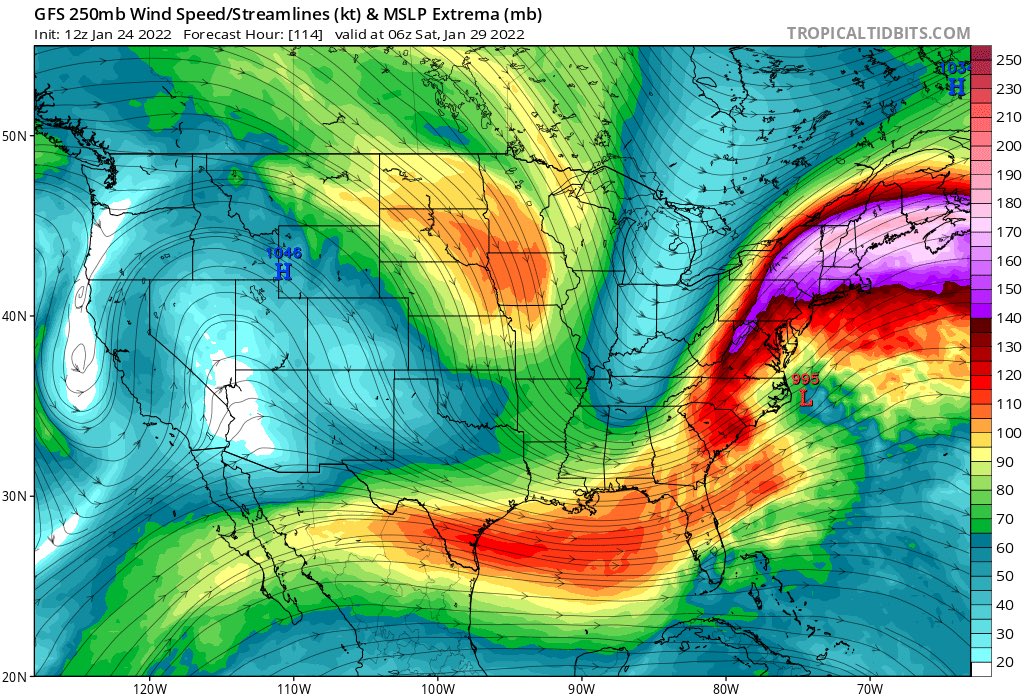
Frank_Wx wrote:That is a big time HP to the north of our storm. There is also an even stronger High in the northern Atlantic. This acts as our east based -NAO, something the models lost but have now brought back. No coincidence we're seeing more 'western' tracks as a result.
Hell yeah, Frank. And that pesky LP off of Cali that we thought could press our ridge East (which I suppose is still possible) could also limit how far west the entire waveguide can shift - which some coasties will be worried about.
MattyICE- Advanced Forecaster
- Posts : 249
Reputation : 6
Join date : 2017-11-10
Age : 38
Location : Clifton, NJ (Eastern Passaic County)
SENJsnowman likes this post
Re: Long Range Discussion 23.0
![]() by Frank_Wx Mon Jan 24, 2022 11:11 am
by Frank_Wx Mon Jan 24, 2022 11:11 am
_________________
_______________________________________________________________________________________________________
CLICK HERE to view NJ Strong Snowstorm Classifications
Frank_Wx- Godzilla Seeker
- Posts : 21305
Reputation : 328
Join date : 2013-01-05
Age : 32
Location : Jersey City, NJ -
Re: Long Range Discussion 23.0
![]() by Frank_Wx Mon Jan 24, 2022 11:15 am
by Frank_Wx Mon Jan 24, 2022 11:15 am
_________________
_______________________________________________________________________________________________________
CLICK HERE to view NJ Strong Snowstorm Classifications
Frank_Wx- Godzilla Seeker
- Posts : 21305
Reputation : 328
Join date : 2013-01-05
Age : 32
Location : Jersey City, NJ -
Bwtr likes this post
Re: Long Range Discussion 23.0
![]() by amugs Mon Jan 24, 2022 11:16 am
by amugs Mon Jan 24, 2022 11:16 am
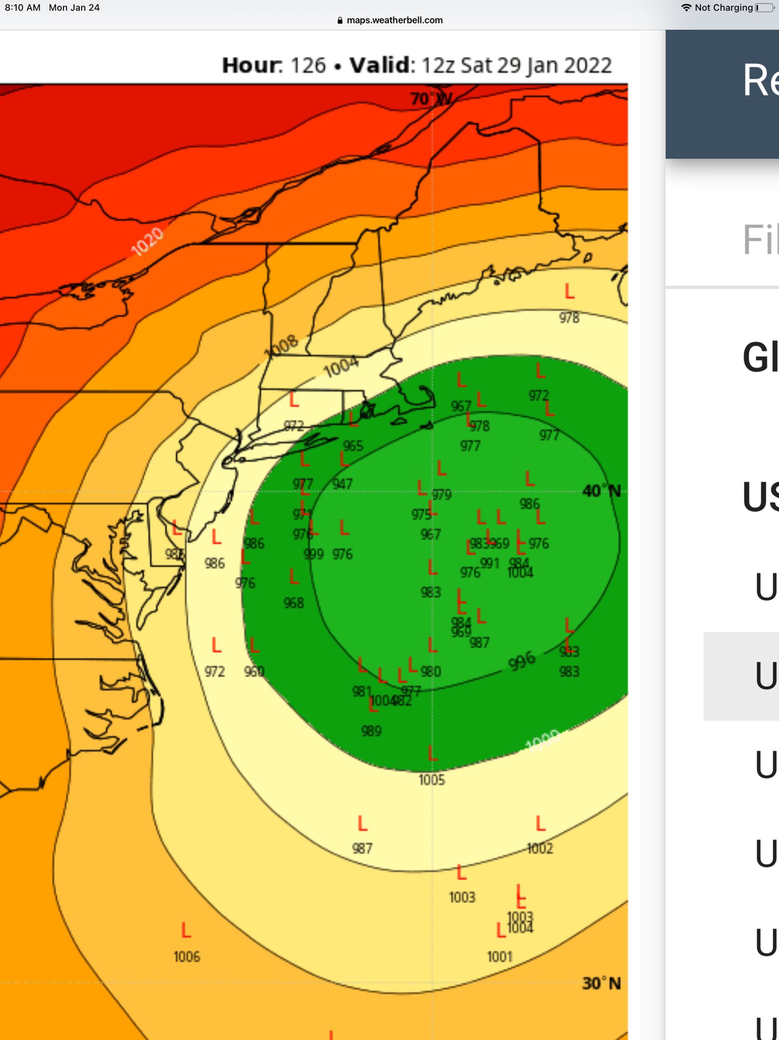
THIS SCREAMS MASSIVE WESTWARD EXPANSION AND TREMENDOUS LIFT AND ENHANCEMENT - THIS JET STREAK IS GREAT!!
Jeez wish it was 48 hours hours not 114!!!
Lets not jump off the cliff if tomorrow we see a SE tick or two
_________________
Mugs
AKA:King: Snow Weenie
Self Proclaimed
WINTER 2014-15 : 55.12" +.02 for 6 coatings (avg. 35")
WINTER 2015-16 Total - 29.8" (Avg 35")
WINTER 2016-17 : 39.5" so far
amugs- Advanced Forecaster - Mod
- Posts : 15095
Reputation : 213
Join date : 2013-01-07
Age : 54
Location : Hillsdale,NJ
Re: Long Range Discussion 23.0
![]() by nutleyblizzard Mon Jan 24, 2022 11:23 am
by nutleyblizzard Mon Jan 24, 2022 11:23 am
nutleyblizzard- Senior Enthusiast
- Posts : 1954
Reputation : 41
Join date : 2014-01-30
Age : 58
Location : Nutley, new jersey
Page 6 of 26 • 1 ... 5, 6, 7 ... 16 ... 26 ![]()
|
|
|