Long Range Discussion 23.0
+45
mikeypizano
bobjohnsonforthehall
Dunnzoo
Scullybutcher
Math23x7
adamfitz1969
Joe Snow
Koroptim
dkodgis
Grselig
bloc1357
Carvin
chief7
essexcountypete
lisalamb
dolphins222
aiannone
emokid51783
hurrysundown23
docstox12
algae888
SoulSingMG
Snow88
Irish
CPcantmeasuresnow
frank 638
weatherwatchermom
dsix85
nutleyblizzard
crippo84
Zhukov1945
Ronfdny
MattyICE
mmanisca
sroc4
jmanley32
richb521
SENJsnowman
lglickman1
phil155
amugs
heehaw453
Radz
rb924119
Frank_Wx
49 posters
Page 2 of 26
Page 2 of 26 •  1, 2, 3 ... 14 ... 26
 Re: Long Range Discussion 23.0
BEWARE OF THE FEBRUARY TORCH FORECASTS AND DOOM AND GLOOM. Thinking my updated preliminary interim thoughts are looking good after some further analysis this morning. Opening week to 10/12 days of February moderate from what we’ve seen, and will see throughout January (which, let’s be honest, has been a cold month. But, I don’t think we torch during that moderation. I think it’s just that, a moderation that averages near normal on the whole, maybe slightly biased warm (say, -.5 to +1). Peak climo, still workable for snow as long as we time it right (yes, this has been a big ask of late).
After the above stretch, I think winter returns pretty harshly, as we see a renewed Aleutian low/+PNA couplet, possibly gaining enough latitude with the PNA ridge to seed and reorient a new -EPO. This will take us right through the rest of February. With so much cold still available to us, once this pattern evolves, it should be more than enough to offset any early-month positive temperature departure (and then some).
I think March, however, gets tricksy, as we really start to change up atmospheric wavelengths in the Northern Hemisphere (they become shorter), and we will have competing atmospheric evolutions. On the whole, I think the CONUS biases below average temperatures with a “coast to coast” cold pattern. BUT, how we get there, I think, will be a wilddddd ride. I think we are going to see A LOT of west-based Atlantic domain blocking develop beginning in the opening days of the month. As a result, I think we are going to see a lot of “bowling ball” lows amplifying into the West Coast as the Stratosphere will be trying to enhance the Tropospheric trough out there, but the tropical forcing will be trying to enhance it over the central and eastern CONUS. So, I think you can envision how storms will amplify as they come into the West Coast, but then get cut off via repeated cyclonic wave breaking over the central CONUS, which will aid in the maintenance of the west-based Atlantic domain blocking. Now, at this time of year, it may not be a pattern that works exceedingly well for the coast, BUT I think that there will be enough cold air around to certainly make it interesting throughout much of the month (at least the first 2.5-3 weeks) before winter breaks.
Overall, that still aligns very well with my initial seasonal thinking, and I think that least so far, that thinking has been on the right track.
Some notes and asides:
1. With how I see March evolving, I think the southern states will have an early start to the severe weather season
2. Based on early thinking, I think April may turn out to be not so nice overall, as we revert back to a lot of cut-off lows following the pattern relaxation in late March lol but it’s no longer winter at that point, so I really don’t care about that part of the forecast haha
3. I’ll try to get a video or two posted today with further explanations.
rb924119- Meteorologist

- Posts : 7033
Join date : 2013-02-06
amugs, dolphins222 and SENJsnowman like this post
 Re: Long Range Discussion 23.0
heehaw453 wrote:The 1/26 deal has potential but like most things this winter the pieces don't come together for us. The tpv is on the wrong side of the Hudson Bay and that will interfere with n/s trough. It will wash the s/s s/w energy right out. You then get a very weak wave that will be small potatoes if anything.
The 1/29-1/31 window IMO is a more legit threat. You have a western ridge that will develop and allow for several n/s s/w's to dive hard on their backside. But there in lies the problem wave spacing has been killing us this year for threats and I have no reason to believe this will be much different. I expect a storm to our s/e.
So that is the rest of January IMO a couple more threat windows and I won't be surprised to see us miss out on each of them. Sure there may be some nickel and dime things, but I don't think we hit the mark. That being said January has not been too bad as we've all seen a lot worse even if it doesn't snow too much more.
We built the pattern, but you can’t exactly forecast simple bad luck. I must admit that I’m entirely surprised to have not come away with something sizable out of this. We will have had a straight month of a highly favorable overall synoptic alignment with nothing to show for it. Disappointing, for sure, but also fascinating and a perfect example of how fickle the weather, and the forecasting of it, can be.
rb924119- Meteorologist

- Posts : 7033
Join date : 2013-02-06
 Re: Long Range Discussion 23.0
rb924119 wrote:heehaw453 wrote:The 1/26 deal has potential but like most things this winter the pieces don't come together for us. The tpv is on the wrong side of the Hudson Bay and that will interfere with n/s trough. It will wash the s/s s/w energy right out. You then get a very weak wave that will be small potatoes if anything.
The 1/29-1/31 window IMO is a more legit threat. You have a western ridge that will develop and allow for several n/s s/w's to dive hard on their backside. But there in lies the problem wave spacing has been killing us this year for threats and I have no reason to believe this will be much different. I expect a storm to our s/e.
So that is the rest of January IMO a couple more threat windows and I won't be surprised to see us miss out on each of them. Sure there may be some nickel and dime things, but I don't think we hit the mark. That being said January has not been too bad as we've all seen a lot worse even if it doesn't snow too much more.
We built the pattern, but you can’t exactly forecast simple bad luck. I must admit that I’m entirely surprised to have not come away with something sizable out of this. We will have had a straight month of a highly favorable overall synoptic alignment with nothing to show for it. Disappointing, for sure, but also fascinating and a perfect example of how fickle the weather, and the forecasting of it, can be.
Rb I hear ya brother but look at what I posted in the other thread of Jan and Discussions from Tomer Burg makes a lot of sense as to the what to the why and why to the what!
_________________
Mugs
AKA:King: Snow Weenie
Self Proclaimed
WINTER 2014-15 : 55.12" +.02 for 6 coatings (avg. 35")
WINTER 2015-16 Total - 29.8" (Avg 35")
WINTER 2016-17 : 39.5" so far

amugs- Advanced Forecaster - Mod

- Posts : 15130
Reputation : 213
Join date : 2013-01-07
Age : 54
Location : Hillsdale,NJ
rb924119 likes this post
heehaw453- Advanced Forecaster

- Posts : 3907
Reputation : 86
Join date : 2014-01-20
Location : Bedminster Township, PA Elevation 600' ASL
phil155 likes this post
 Re: Long Range Discussion 23.0
Tuesday has sparked some interest for a possibility N&W.
Need a few tweaks for the coastal plain but a good event for N&W possibly. That Clipper in SE CAN needs to get out of there.


Need a few tweaks for the coastal plain but a good event for N&W possibly. That Clipper in SE CAN needs to get out of there.


_________________
Mugs
AKA:King: Snow Weenie
Self Proclaimed
WINTER 2014-15 : 55.12" +.02 for 6 coatings (avg. 35")
WINTER 2015-16 Total - 29.8" (Avg 35")
WINTER 2016-17 : 39.5" so far

amugs- Advanced Forecaster - Mod

- Posts : 15130
Reputation : 213
Join date : 2013-01-07
Age : 54
Location : Hillsdale,NJ
 Re: Long Range Discussion 23.0
Canadian is colder and on board as well for 1/25- Walt Drag preaches, you need the CMC on board and being colder for a snowstorm.
Deeper dig than GFS

Deeper dig than GFS

Last edited by amugs on Fri Jan 21, 2022 12:29 pm; edited 1 time in total
_________________
Mugs
AKA:King: Snow Weenie
Self Proclaimed
WINTER 2014-15 : 55.12" +.02 for 6 coatings (avg. 35")
WINTER 2015-16 Total - 29.8" (Avg 35")
WINTER 2016-17 : 39.5" so far

amugs- Advanced Forecaster - Mod

- Posts : 15130
Reputation : 213
Join date : 2013-01-07
Age : 54
Location : Hillsdale,NJ
Ronfdny likes this post
 Re: Long Range Discussion 23.0
Lee Goldberg last night said February temps look above normal not want I wanted to hear for snow lovers
Ronfdny- Posts : 6
Reputation : 0
Join date : 2022-01-21
 Re: Long Range Discussion 23.0
None of this surprises me, if its not go be any real snowstorms which is 3-6 for me at least then let it be warm and sunny or cludy, no rain. I cannot stand bitter cold and sun. I say after 1st week of Feb if we havent seen a decent storm I will be ready for spring to be here. many won't like this comment but putting my feeling out there as most do this too.

jmanley32- Senior Enthusiast

- Posts : 20635
Reputation : 108
Join date : 2013-12-12
Age : 43
Location : Yonkers, NY

Zhukov1945- Posts : 138
Reputation : 8
Join date : 2018-03-21
Location : Clinton Township NJ

crippo84- Posts : 383
Reputation : 20
Join date : 2013-11-07
Age : 40
Location : East Village, NYC
Zhukov1945 and phil155 like this post
 Re: Long Range Discussion 23.0
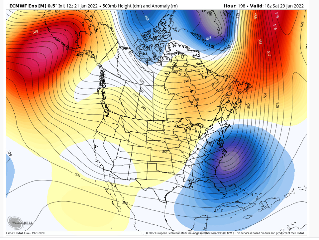
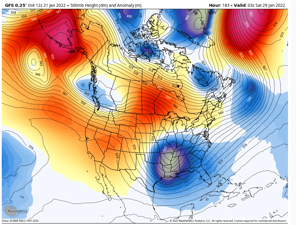
I normally don't put an op model H5 at that range, but there is a window during 1-29-1-31 which a western ridge will pump up significantly in conjunction with an east based block. Most likely the active N/S will drop a s/w to ride down the shoot and amplify. If it dives at the right time as that ridge pumps and has enough room to amplify there will be a major EC snowstorm. Right now I'd say it dives either too late which pushes it to our SE or it gets inhibited by another trough which dampens heights.
heehaw453- Advanced Forecaster

- Posts : 3907
Reputation : 86
Join date : 2014-01-20
Location : Bedminster Township, PA Elevation 600' ASL
Zhukov1945 likes this post
 Re: Long Range Discussion 23.0
Im not putting any stock in this printout at this point. I'll treat that storm as noise for now.

mmanisca- Pro Enthusiast

- Posts : 299
Reputation : 3
Join date : 2013-01-23
Age : 65
Location : Deer Park, Long Island
 Re: Long Range Discussion 23.0
Most of the 12Z guidance today looks like Can/GFS/Icon for 1/25 threat. The Euro has the n/s squash s/s the energy and it's a nothing burger. I'm kind of glad the Euro shows this ATTM actually. Again this won't be sig, but could be a 1-3/2-4" kind of deal for nw of I95 IF the s/s energy is not interfered with by the n/s.
Last edited by heehaw453 on Fri Jan 21, 2022 1:57 pm; edited 1 time in total
heehaw453- Advanced Forecaster

- Posts : 3907
Reputation : 86
Join date : 2014-01-20
Location : Bedminster Township, PA Elevation 600' ASL
 Re: Long Range Discussion 23.0
mmanisca wrote:Im not putting any stock in this printout at this point. I'll treat that storm as noise for now.
I think there will be a sig storm, but my bet now is it probably misses to our SE... Until I see luck change that's my sentiment.
heehaw453- Advanced Forecaster

- Posts : 3907
Reputation : 86
Join date : 2014-01-20
Location : Bedminster Township, PA Elevation 600' ASL
phil155 likes this post
 Re: Long Range Discussion 23.0
heehaw453 wrote:mmanisca wrote:Im not putting any stock in this printout at this point. I'll treat that storm as noise for now.
I think there will be a sig storm, but my bet now is it probably misses to our SE... Until I see luck change that's my sentiment.
I have to agree as they say the trend is your friend and right now the trend is to the southeast
Last edited by phil155 on Fri Jan 21, 2022 2:09 pm; edited 1 time in total
phil155- Pro Enthusiast

- Posts : 494
Reputation : 4
Join date : 2019-12-16
heehaw453 likes this post
 Re: Long Range Discussion 23.0
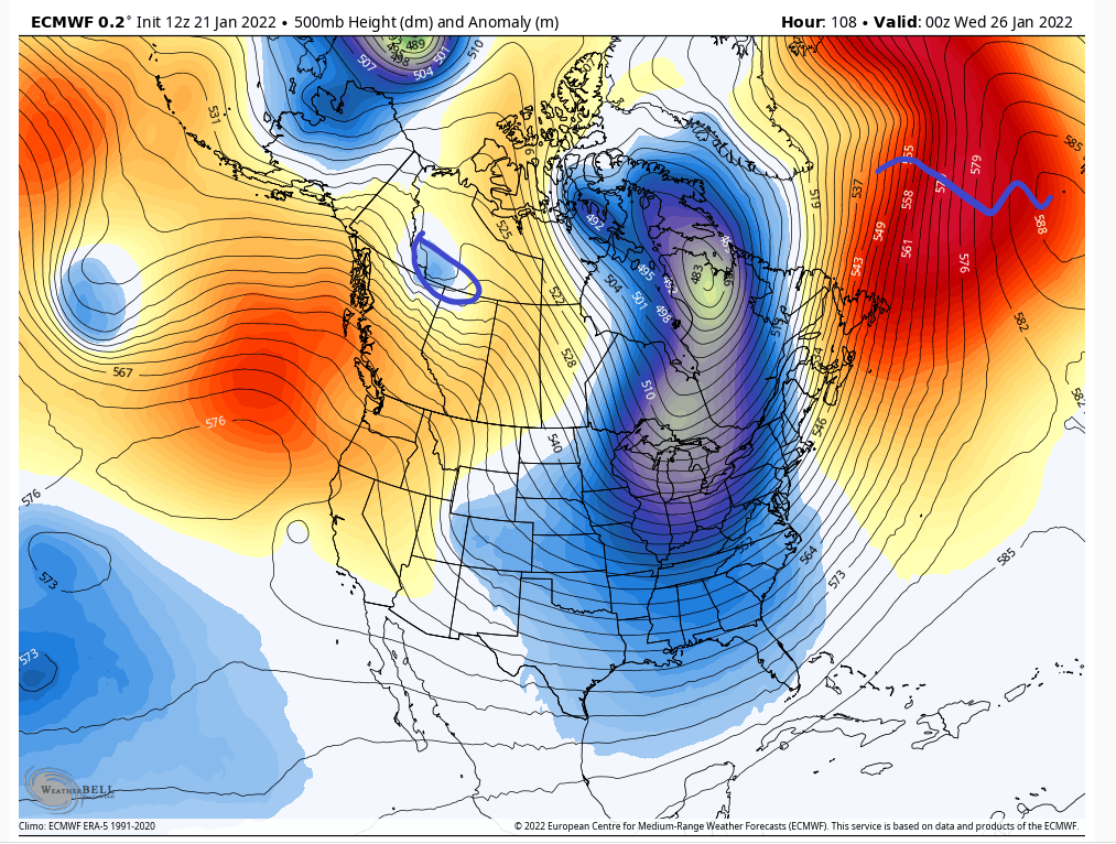
I should also point out that this storm for 1/29-1/30 is not in fantasy land range. The genesis of it is here and H5 at this range is not exact, but general idea is probably accurate. The details of course at this range are non-sense, but this setup most likely yields a sig storm. Fairly confident on that so we will most likely go through the highs/lows in about 3 days or so. 

heehaw453- Advanced Forecaster

- Posts : 3907
Reputation : 86
Join date : 2014-01-20
Location : Bedminster Township, PA Elevation 600' ASL
SENJsnowman and Zhukov1945 like this post
 Re: Long Range Discussion 23.0
Yea I know it’s out in fantasy land and details need to be ironed out, but the Euro has come on board along with the GFS and CMC for a strong coastal at day 10.

nutleyblizzard- Senior Enthusiast

- Posts : 1963
Reputation : 41
Join date : 2014-01-30
Age : 58
Location : Nutley, new jersey
heehaw453- Advanced Forecaster

- Posts : 3907
Reputation : 86
Join date : 2014-01-20
Location : Bedminster Township, PA Elevation 600' ASL
chief7 and Zhukov1945 like this post

jmanley32- Senior Enthusiast

- Posts : 20635
Reputation : 108
Join date : 2013-12-12
Age : 43
Location : Yonkers, NY
heehaw453 likes this post
 Re: Long Range Discussion 23.0
You get big dog storms with some of the following ingredients. Just sayin'
blocking
NW side of a rapidly maturing cyclone
deep moisture fetch
sufficient cold air
sufficient space for the cyclone
additional energy phasing into the storm during its maturation phase
blocking
NW side of a rapidly maturing cyclone
deep moisture fetch
sufficient cold air
sufficient space for the cyclone
additional energy phasing into the storm during its maturation phase
heehaw453- Advanced Forecaster

- Posts : 3907
Reputation : 86
Join date : 2014-01-20
Location : Bedminster Township, PA Elevation 600' ASL
Grselig likes this post
 Re: Long Range Discussion 23.0
You need not look any further than next week. 8-9 days is an enternity for wx.
4 days out and we see a midweek storm that we need to watch.
The Clipper is weaker which is good allowing for more room for the Southern energy to dig and doesn't warm the boundary layer as much.
Fks we have as Frank and Haw has pointed out some blocking can do wonders.
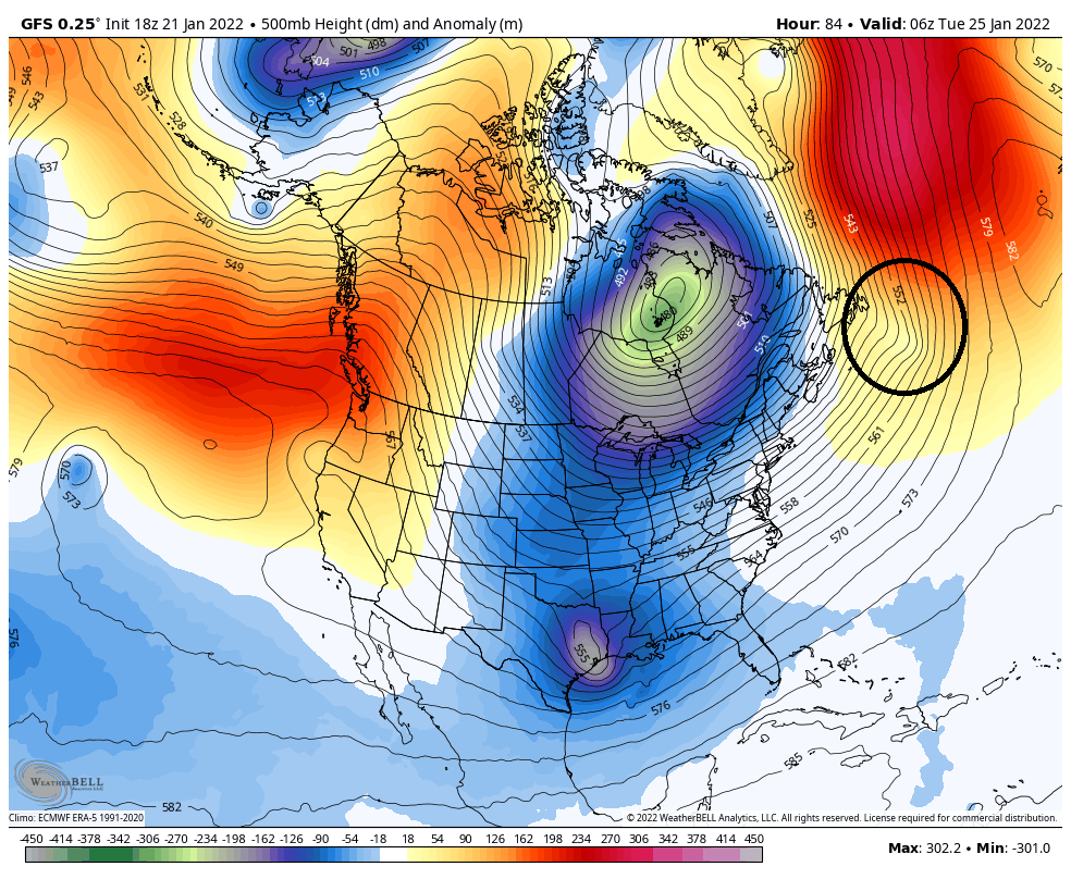
4 days out and we see a midweek storm that we need to watch.
The Clipper is weaker which is good allowing for more room for the Southern energy to dig and doesn't warm the boundary layer as much.
Fks we have as Frank and Haw has pointed out some blocking can do wonders.

_________________
Mugs
AKA:King: Snow Weenie
Self Proclaimed
WINTER 2014-15 : 55.12" +.02 for 6 coatings (avg. 35")
WINTER 2015-16 Total - 29.8" (Avg 35")
WINTER 2016-17 : 39.5" so far

amugs- Advanced Forecaster - Mod

- Posts : 15130
Reputation : 213
Join date : 2013-01-07
Age : 54
Location : Hillsdale,NJ
 Re: Long Range Discussion 23.0
Gfs for the win next weekend lol
Radz- Pro Enthusiast

- Posts : 1028
Reputation : 17
Join date : 2013-01-12
Location : Cortlandt Manor NY
 Re: Long Range Discussion 23.0
The interaction of this developing storm on 1/29 could be highly influenced by the TPV n/s energy. These are details that are just too far out to have any analysis on. We just have to stay tuned and understand this may have no sig impact on our area...
Couple of things I have growing confidence in for 1/29 timeframe.
A major storm developing somewhere off the east coast
A slow moving storm
Good western ridge/east based blocking
Absolutely no confidence ATTM
The interaction of the n/s tpv on the developing storm
The placement of the storm w.r.t. to EC
Redevelopment of the storm
heehaw453- Advanced Forecaster

- Posts : 3907
Reputation : 86
Join date : 2014-01-20
Location : Bedminster Township, PA Elevation 600' ASL
 Re: Long Range Discussion 23.0
heehaw453 wrote:The interaction of this developing storm on 1/29 could be highly influenced by the TPV n/s energy. These are details that are just too far out to have any analysis on. We just have to stay tuned and understand this may have no sig impact on our area...
Couple of things I have growing confidence in for 1/29 timeframe.
A major storm developing somewhere off the east coast
A slow moving storm
Good western ridge/east based blocking
Absolutely no confidence ATTM
The interaction of the n/s tpv on the developing storm
The placement of the storm w.r.t. to EC
Redevelopment of the storm
What does n/s tpv stand for? Northern stream...?

crippo84- Posts : 383
Reputation : 20
Join date : 2013-11-07
Age : 40
Location : East Village, NYC
 Re: Long Range Discussion 23.0
crippo84 wrote:heehaw453 wrote:The interaction of this developing storm on 1/29 could be highly influenced by the TPV n/s energy. These are details that are just too far out to have any analysis on. We just have to stay tuned and understand this may have no sig impact on our area...
Couple of things I have growing confidence in for 1/29 timeframe.
A major storm developing somewhere off the east coast
A slow moving storm
Good western ridge/east based blocking
Absolutely no confidence ATTM
The interaction of the n/s tpv on the developing storm
The placement of the storm w.r.t. to EC
Redevelopment of the storm
What does n/s tpv stand for? Northern stream...?
Tropospheric polar vortex which is the lower half of the polar vortex.
heehaw453- Advanced Forecaster

- Posts : 3907
Reputation : 86
Join date : 2014-01-20
Location : Bedminster Township, PA Elevation 600' ASL
crippo84 likes this post
 Re: Long Range Discussion 23.0
Too many variables at play here which has been the general theme this winter. Since we don’t have a west based block, every storm threat is a thread the needle event. While I want a blockbuster storm more then anyone, I refuse to get pulled in only to get hood winked in the end. I’ll watch the model runs in the coming days, but I won’t bite till Wednesday if the threat is still there.heehaw453 wrote:The interaction of this developing storm on 1/29 could be highly influenced by the TPV n/s energy. These are details that are just too far out to have any analysis on. We just have to stay tuned and understand this may have no sig impact on our area...
Couple of things I have growing confidence in for 1/29 timeframe.
A major storm developing somewhere off the east coast
A slow moving storm
Good western ridge/east based blocking
Absolutely no confidence ATTM
The interaction of the n/s tpv on the developing storm
The placement of the storm w.r.t. to EC
Redevelopment of the storm

nutleyblizzard- Senior Enthusiast

- Posts : 1963
Reputation : 41
Join date : 2014-01-30
Age : 58
Location : Nutley, new jersey
heehaw453 likes this post
 Re: Long Range Discussion 23.0
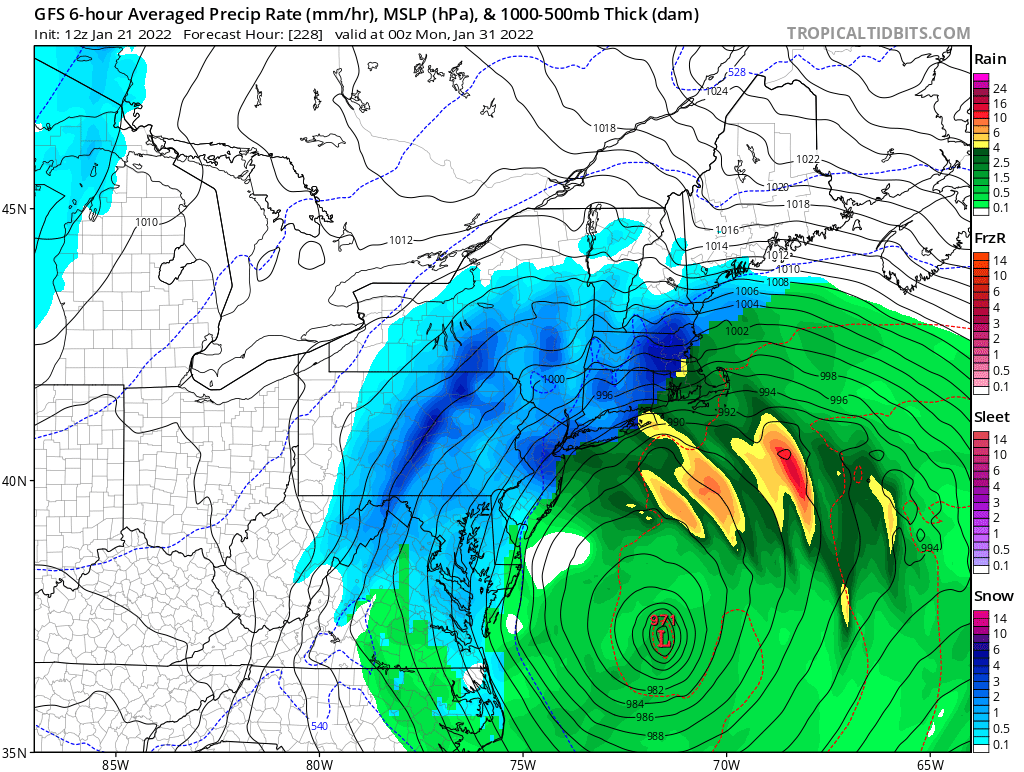
LOL you guys see the GFS I think it was last night? Nukes Eastern CT to cape with Franzroidzilla (yes a new term for well above 36 lol) 36-40+ inches wouldn't that be a smack in the head if that happened. It won't and my guess is it misses entirely but we will see it is 8 days out, not fantasy land but still as stated above way to far out to put any stance in it.

jmanley32- Senior Enthusiast

- Posts : 20635
Reputation : 108
Join date : 2013-12-12
Age : 43
Location : Yonkers, NY
Page 2 of 26 •  1, 2, 3 ... 14 ... 26
Page 2 of 26
Permissions in this forum:
You cannot reply to topics in this forum|
|
|

 Home
Home
