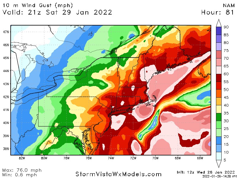
Tracking JAN 29th 2022 'The Phase'
+51
DWay
Bwtr
Quietace
Joe Snow
Sanchize06
JT33
Zhukov1945
uanswer2me
gigs68
billg315
freezerburn
dolphins222
rb924119
hurrysundown23
dsix85
docstox12
crippo84
lglickman1
SoulSingMG
mikeypizano
TheAresian
moleson
Fededle22
skinsfan1177
Wheezer
Artechmetals
Irish
weatherwatchermom
Dunnzoo
bloc1357
Scullybutcher
hyde345
SNOW MAN
richb521
RJB8525
Carvin
essexcountypete
nutleyblizzard
CPcantmeasuresnow
phil155
MattyICE
amugs
mmanisca
bobjohnsonforthehall
aiannone
sroc4
SENJsnowman
jmanley32
frank 638
heehaw453
Frank_Wx
55 posters
Page 1 of 31
Page 1 of 31 • 1, 2, 3 ... 16 ... 31 
 Tracking JAN 29th 2022 'The Phase'
We are approaching a critical moment in time when models will begin converging on a solution for Saturday's storm. To this point, we have seen drastic run to run differences that have lead to loud and dramatic outbursts, above normal perspiration and the name of my first child (only if you have been following will you get this).
We have also seen one of our very own members sacrifice themselves for the month of February. Our dearly beloved @CPcantmeasuresnow. Its because of him I felt compelled to start a thread to track this monster of a storm. It is indeed a monster with incredible opportunity.
Let's get to it.
Here is a comparison GIF of the 06z GFS and 06z EURO at the 500mb level. The former shows a scraper with minimal impact while the latter brings Roidzilla impacts to our area. This is a snapshot of Thursday night.
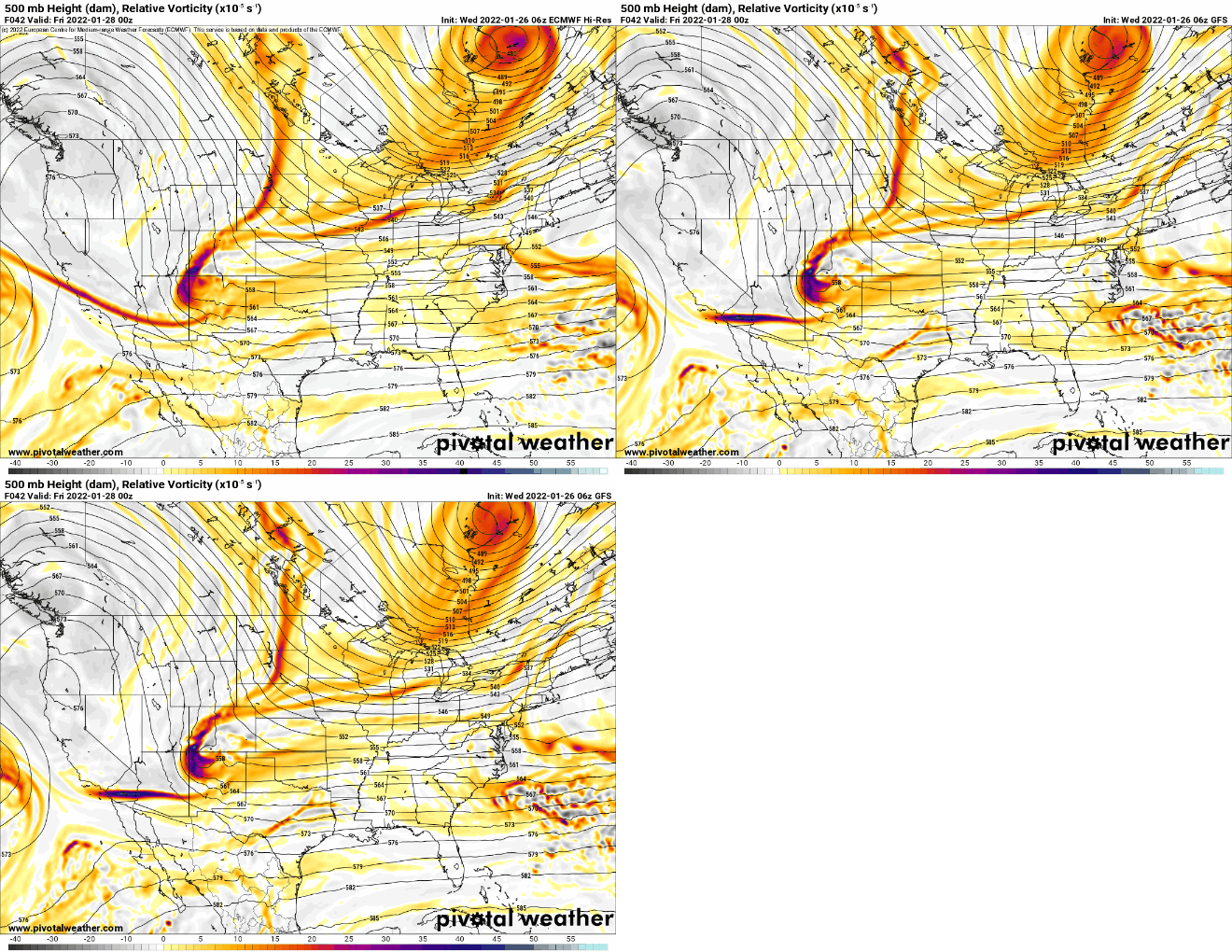
Amazing that the EURO is actually the furthest west with our initial disturbance (southern branch) than the GFS. You can see it is dug nicely into the 4 corners. But that is actually not the issue...it is the northern branch, or energy that is over the Dakotas. Notice how on the EURO it's placed further west, while the GFS is east of the EURO. Because of this, the northern and southern branches are not vertically aligned (on either models, but especially the GFS).
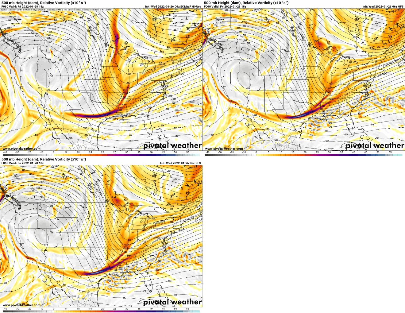
Here we are Friday afternoon. Not a whole lot of differences with our western ridge axis but vast differences downstream. Notice how on the EURO, the northern energy is 'pointed' southward. Almost like a pencil. On the GFS its pretty scattered over the Great Lakes, and we're seeing a more positively tilted trough. Both models are hanging back some southern energy over Texas, however. I think the main takeaway is the EURO is digging this energy into the backside of the trough. Notice the orange colors over Oklahoma and Kansas on the EURO compared to GFS. This is extremely important because it's clearly moving toward a full latitude phase between both branches of energy.
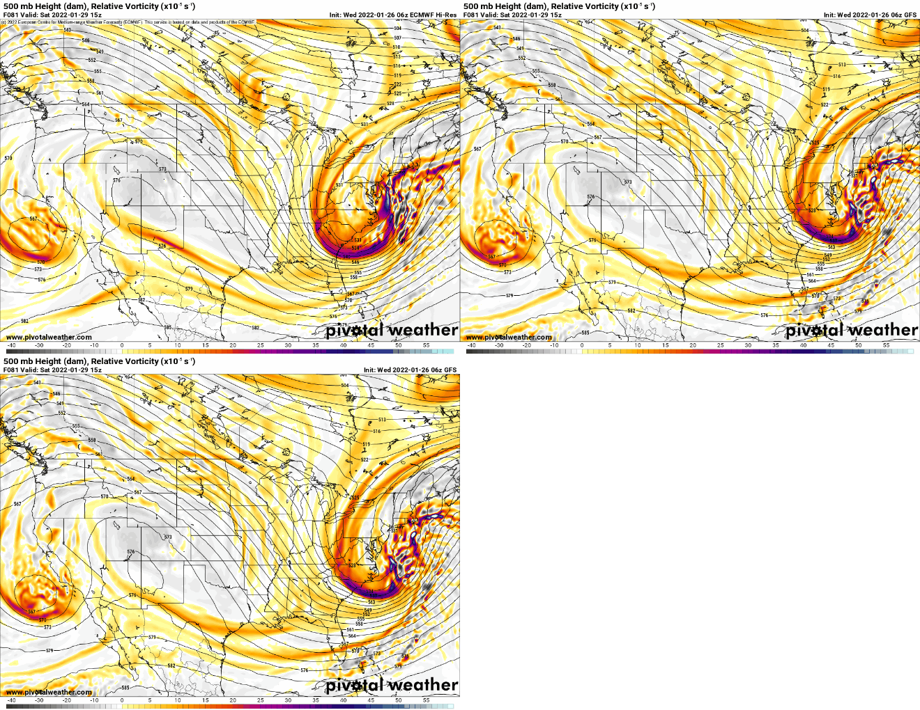
This takes us to Saturday morning. EURO maintains a better ridge axis as the ULL off west coast is more west, keeping the ridge intact and preventing it from rolling east. On the GFS it is slipping a bit, and the whole evolution of the trough is thrown off. The EURO keeps the trough neutral and on a path toward negative, while closing off at 500mb and capturing the surface low. Meaning, the storm off the coast has been captured and tugged closer to the coast, hence why the 06z EURO showed Roidzilla conditions.
To see these differences at the 500mb level as of 06z this morning tells me we are not done with surprises, and we're far from knowing the final solution. As Scott likes to say...WE TRACK!
We have also seen one of our very own members sacrifice themselves for the month of February. Our dearly beloved @CPcantmeasuresnow. Its because of him I felt compelled to start a thread to track this monster of a storm. It is indeed a monster with incredible opportunity.
Let's get to it.
Here is a comparison GIF of the 06z GFS and 06z EURO at the 500mb level. The former shows a scraper with minimal impact while the latter brings Roidzilla impacts to our area. This is a snapshot of Thursday night.

Amazing that the EURO is actually the furthest west with our initial disturbance (southern branch) than the GFS. You can see it is dug nicely into the 4 corners. But that is actually not the issue...it is the northern branch, or energy that is over the Dakotas. Notice how on the EURO it's placed further west, while the GFS is east of the EURO. Because of this, the northern and southern branches are not vertically aligned (on either models, but especially the GFS).

Here we are Friday afternoon. Not a whole lot of differences with our western ridge axis but vast differences downstream. Notice how on the EURO, the northern energy is 'pointed' southward. Almost like a pencil. On the GFS its pretty scattered over the Great Lakes, and we're seeing a more positively tilted trough. Both models are hanging back some southern energy over Texas, however. I think the main takeaway is the EURO is digging this energy into the backside of the trough. Notice the orange colors over Oklahoma and Kansas on the EURO compared to GFS. This is extremely important because it's clearly moving toward a full latitude phase between both branches of energy.

This takes us to Saturday morning. EURO maintains a better ridge axis as the ULL off west coast is more west, keeping the ridge intact and preventing it from rolling east. On the GFS it is slipping a bit, and the whole evolution of the trough is thrown off. The EURO keeps the trough neutral and on a path toward negative, while closing off at 500mb and capturing the surface low. Meaning, the storm off the coast has been captured and tugged closer to the coast, hence why the 06z EURO showed Roidzilla conditions.
To see these differences at the 500mb level as of 06z this morning tells me we are not done with surprises, and we're far from knowing the final solution. As Scott likes to say...WE TRACK!
_________________
_______________________________________________________________________________________________________
CLICK HERE to view NJ Strong Snowstorm Classifications
CPcantmeasuresnow, dolphins222, SoulSingMG, heehaw453 and Irish like this post
heehaw453- Advanced Forecaster

- Posts : 3906
Reputation : 86
Join date : 2014-01-20
Location : Bedminster Township, PA Elevation 600' ASL
 Re: Tracking JAN 29th 2022 'The Phase'
Thank you frank and everyone for the update let’s hope and pray we all get a decent snowstorm 


frank 638- Senior Enthusiast

- Posts : 2843
Reputation : 37
Join date : 2016-01-01
Age : 40
Location : bronx ny
phil155 likes this post
 Re: Tracking JAN 29th 2022 'The Phase'
Thanks for the explanation Frank, sounds intriguing and doable. I thought the issue was the southern energy holding back but we determined that wasn't the issue? Is that what you're saying. thats interesting. Hoping to see all senarious like Euro show today, It isn't good that this looks like it may creep up on many people, it is only wed but that leaves tomorrow to prepare, and wouldnt they be issuing watches by tonight? I think its what 36 or 48 hrs b4 for watches and 24 hrs for warnings? Nonetheless whether it happens or not you guys put so much effort in and keep your cool which if I put as much work into it and it busted I would be very sour. Guess thats why I am not you or a admin which is okay with me : )

jmanley32- Senior Enthusiast

- Posts : 20535
Reputation : 108
Join date : 2013-12-12
Age : 43
Location : Yonkers, NY
 Re: Tracking JAN 29th 2022 'The Phase'
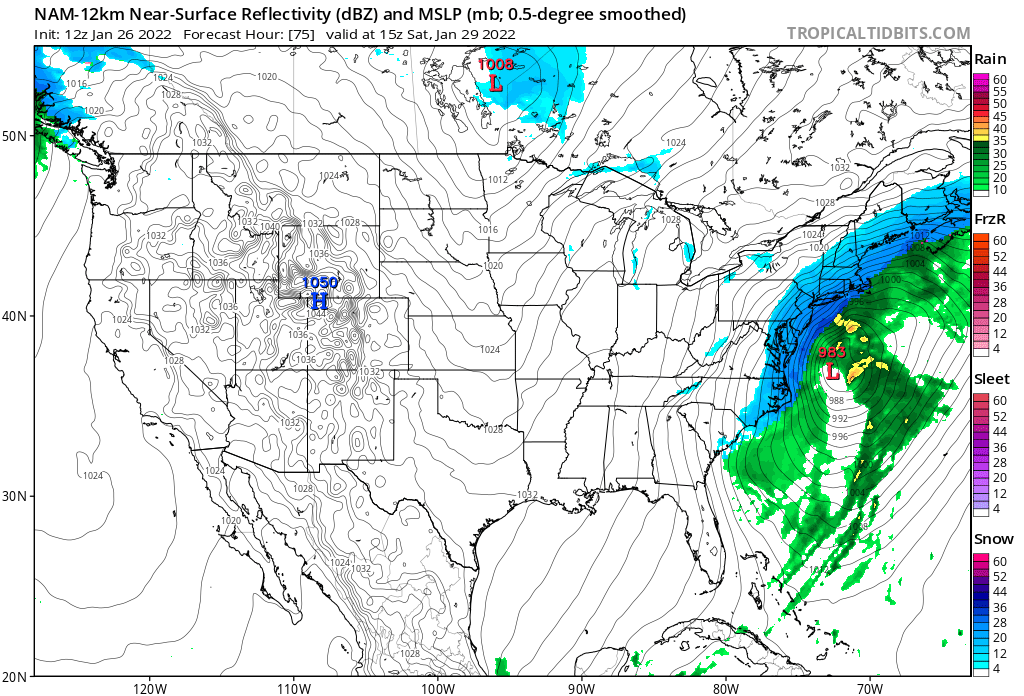
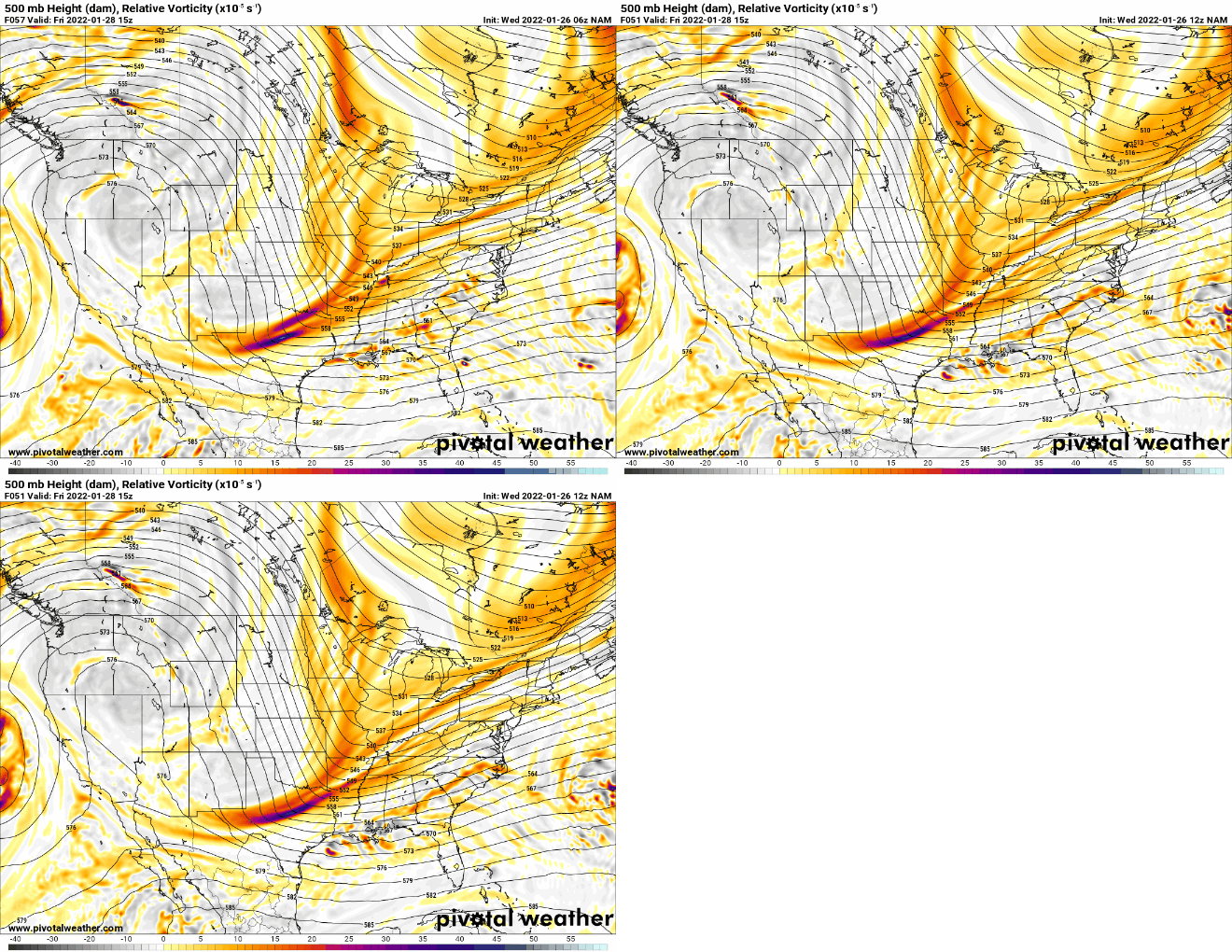
12z NAM has begun and both the northern and southern stream energies are onshore and should be better sampled compared to the last few days. As a side note, I have a busy work day and will not be as active as yesterday. So play by play posts will be very limited.
_________________
_______________________________________________________________________________________________________
CLICK HERE to view NJ Strong Snowstorm Classifications
 Re: Tracking JAN 29th 2022 'The Phase'
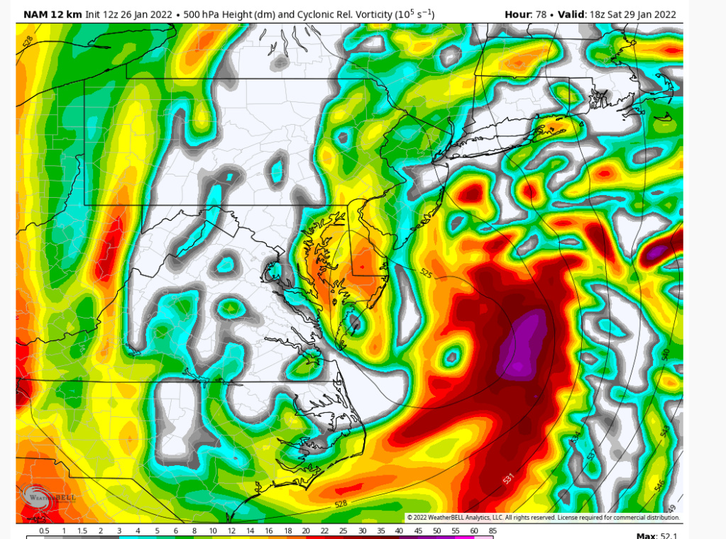
NAM is better...northern energy is pointing south and tugged west a bit


_________________
_______________________________________________________________________________________________________
CLICK HERE to view NJ Strong Snowstorm Classifications
 Re: Tracking JAN 29th 2022 'The Phase'
While very tricky, once our crew here gets done with it, it becomes VERY understandable. It’s all about what happens in that 500vort screen- and hopefully seeing that red glow hit Oklahoma and Kansas and watching the energy streams phase together! Please please please! lol
The last couple of days been straight up exhilarating and harrowing. And truthfully, the Shore (not so much LI I think) is exactly one model consensus lean to the East to being in 1-3”. And it’s just now the time where being in the bullseye is NOT where you want to be. Unless of course you been there all week, then you just sit paralyzed staring at the screens…praying it all stays the same and doesn’t change once…then get it into the short range models hands and just pray.
So far, best week ever!!!! And remember, we still need the phase of course, but we are just now hitting the time of the most recurring trend there is, right of track bias, aka the 24-48 nw trend…let’s see.
SENJsnowman- Senior Enthusiast

- Posts : 1189
Reputation : 61
Join date : 2017-01-06
Age : 51
Location : Bayville, NJ
essexcountypete and phil155 like this post
 Re: Tracking JAN 29th 2022 'The Phase'
Much improved

_________________
_______________________________________________________________________________________________________
CLICK HERE to view NJ Strong Snowstorm Classifications
 Re: Tracking JAN 29th 2022 'The Phase'
Last edited by jmanley32 on Wed Jan 26, 2022 9:42 am; edited 1 time in total

jmanley32- Senior Enthusiast

- Posts : 20535
Reputation : 108
Join date : 2013-12-12
Age : 43
Location : Yonkers, NY
 Re: Tracking JAN 29th 2022 'The Phase'
The ULL completely closed off around the Delmarva with negatively tilted trough. Great run.
heehaw453- Advanced Forecaster

- Posts : 3906
Reputation : 86
Join date : 2014-01-20
Location : Bedminster Township, PA Elevation 600' ASL
 Re: Tracking JAN 29th 2022 'The Phase'
12Z NAM run!!!!!!


_________________
"In weather and in life, there's no winning and losing; there's only winning and learning."
WINTER 2012/2013 TOTALS 43.65"WINTER 2017/2018 TOTALS 62.85" WINTER 2022/2023 TOTALS 4.9"
WINTER 2013/2014 TOTALS 64.85"WINTER 2018/2019 TOTALS 14.25" WINTER 2023/2024 TOTALS 13.1"
WINTER 2014/2015 TOTALS 71.20"WINTER 2019/2020 TOTALS 6.35"
WINTER 2015/2016 TOTALS 35.00"WINTER 2020/2021 TOTALS 37.75"
WINTER 2016/2017 TOTALS 42.25"WINTER 2021/2022 TOTALS 31.65"

sroc4- Admin

- Posts : 8354
Reputation : 302
Join date : 2013-01-07
Location : Wading River, LI
CPcantmeasuresnow, SNOW MAN, SoulSingMG, weatherwatchermom and Irish like this post
heehaw453- Advanced Forecaster

- Posts : 3906
Reputation : 86
Join date : 2014-01-20
Location : Bedminster Township, PA Elevation 600' ASL
 Re: Tracking JAN 29th 2022 'The Phase'
_________________
-Alex Iannone-

aiannone- Senior Enthusiast - Mod

- Posts : 4815
Reputation : 92
Join date : 2013-01-07
Location : Saint James, LI (Northwest Suffolk Co.)
 Re: Tracking JAN 29th 2022 'The Phase'
For the NAM, is the much improved part within it's 60 hour window? I know we can't look much at it once it gets here which is outside that 60 hour window, but some of what is happening in the Southwest and around, say, Oklahoma, is that within the 60 hour window and thus that part might be somewhat more reliable?

bobjohnsonforthehall- Posts : 311
Reputation : 19
Join date : 2016-10-02
Location : Flemington NJ
 Re: Tracking JAN 29th 2022 'The Phase'
It's going to come down to that n/s energy. It's encouraging that as sampling is occurring we are not walking backwards. Still have to be really cautious IMO.
heehaw453- Advanced Forecaster

- Posts : 3906
Reputation : 86
Join date : 2014-01-20
Location : Bedminster Township, PA Elevation 600' ASL
essexcountypete likes this post
 Re: Tracking JAN 29th 2022 'The Phase'
Just another thing on this is this can tuck much further than what is being shown. and stall somewhere if it deepens like progged.
heehaw453- Advanced Forecaster

- Posts : 3906
Reputation : 86
Join date : 2014-01-20
Location : Bedminster Township, PA Elevation 600' ASL

aiannone- Senior Enthusiast - Mod

- Posts : 4815
Reputation : 92
Join date : 2013-01-07
Location : Saint James, LI (Northwest Suffolk Co.)
weatherwatchermom likes this post
 Re: Tracking JAN 29th 2022 'The Phase'
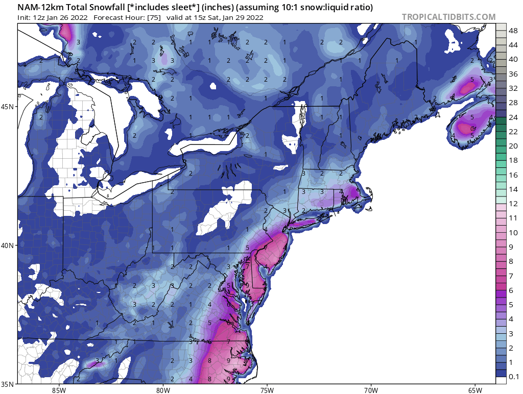
Temps 0-10 above. Talk about ratios
_________________
-Alex Iannone-

aiannone- Senior Enthusiast - Mod

- Posts : 4815
Reputation : 92
Join date : 2013-01-07
Location : Saint James, LI (Northwest Suffolk Co.)
 Re: Tracking JAN 29th 2022 'The Phase'
Lloking like its our turn here in Suffolk county! Going to Crushed!aiannone wrote:Temps 0-10 above. Talk about ratios

mmanisca- Pro Enthusiast

- Posts : 299
Reputation : 3
Join date : 2013-01-23
Age : 65
Location : Deer Park, Long Island
gigs68 likes this post
 Re: Tracking JAN 29th 2022 'The Phase'
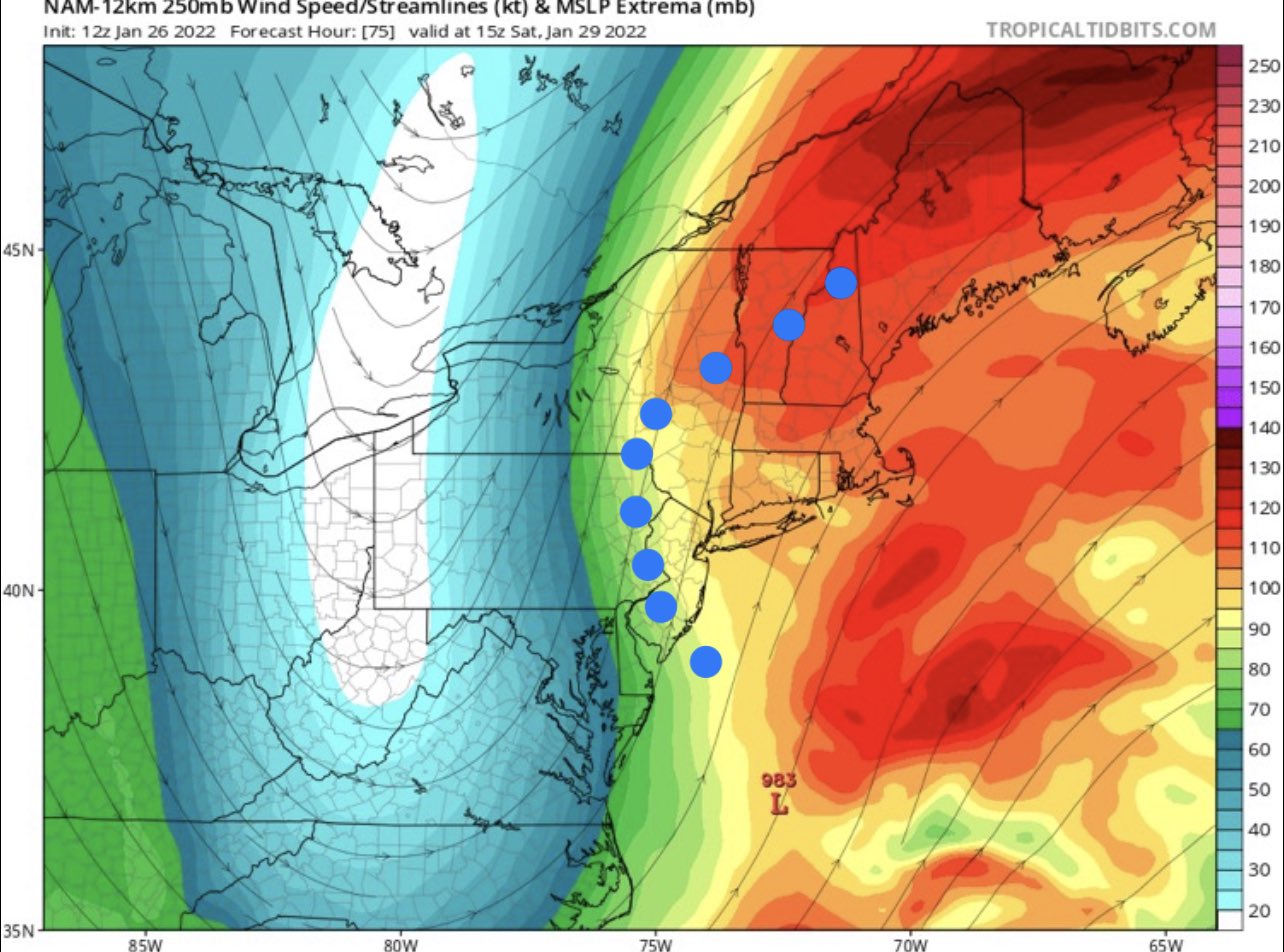
This map is from a pro met - blue dots are teh extent of the heavy snow to the Jet Streak overhead
Money= Jet Streak


Money= Jet Streak


_________________
Mugs
AKA:King: Snow Weenie
Self Proclaimed
WINTER 2014-15 : 55.12" +.02 for 6 coatings (avg. 35")
WINTER 2015-16 Total - 29.8" (Avg 35")
WINTER 2016-17 : 39.5" so far

amugs- Advanced Forecaster - Mod

- Posts : 15095
Reputation : 213
Join date : 2013-01-07
Age : 54
Location : Hillsdale,NJ
MattyICE likes this post
 Re: Tracking JAN 29th 2022 'The Phase'
mmanisca wrote:Lloking like its our turn here in Suffolk county! Going to Crushed!aiannone wrote:Temps 0-10 above. Talk about ratios
Sure does look like it....as of now...
_________________
-Alex Iannone-

aiannone- Senior Enthusiast - Mod

- Posts : 4815
Reputation : 92
Join date : 2013-01-07
Location : Saint James, LI (Northwest Suffolk Co.)
mmanisca likes this post
 Re: Tracking JAN 29th 2022 'The Phase'
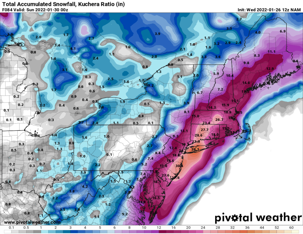
It could all turn bad - but consider that the NAM and Euro are run at superior resolutions to most others. I have to wonder if that’s at play here. If so, even though I am admittedly biased, this will trend towards a classic inside benchmark track and widespread 1-2’ storm. Things like favorable jet streak, and moisture transfer, and banding, and latent heat release are all still hanging out there for the higher res shorter range models. I like where things stand, cautiously optimistic.
MattyICE- Advanced Forecaster

- Posts : 249
Reputation : 6
Join date : 2017-11-10
Age : 38
Location : Clifton, NJ (Eastern Passaic County)
sroc4, amugs and heehaw453 like this post
 Re: Tracking JAN 29th 2022 'The Phase'
Yes SRCO said 15:1 and some 20:1 plus - seriously may rival the great 1899 Arctic Outbreaks Strom that had rations 20-30:1 up and down the entire east coast. AS we get closer we can hone in on the finer details but lets get tehre first peeps.aiannone wrote:Temps 0-10 above. Talk about ratios
Need the other 12Z models to hold and the EURO to give us some Petty Lovin - "Won't Back Down" CP your man and for teh sacrifice of the good I shall join you in snowstorm weather martyrdom my good man as I was once the self proclaimed "King Snow Weenie" back in the day!! God' speed to you all and have patience, logic, and reasoning as we move forward with our model runs peeps.
Time will tell so hang tight.
_________________
Mugs
AKA:King: Snow Weenie
Self Proclaimed
WINTER 2014-15 : 55.12" +.02 for 6 coatings (avg. 35")
WINTER 2015-16 Total - 29.8" (Avg 35")
WINTER 2016-17 : 39.5" so far

amugs- Advanced Forecaster - Mod

- Posts : 15095
Reputation : 213
Join date : 2013-01-07
Age : 54
Location : Hillsdale,NJ
CPcantmeasuresnow likes this post
 Re: Tracking JAN 29th 2022 'The Phase'
Nice for a change to see that the abnormally warm waters will be supplying a lot of energy and moisture into this system without dealing with a changeover to rain. (at least so far!)aiannone wrote:mmanisca wrote:Lloking like its our turn here in Suffolk county! Going to Crushed!aiannone wrote:Temps 0-10 above. Talk about ratios
Sure does look like it....as of now...

mmanisca- Pro Enthusiast

- Posts : 299
Reputation : 3
Join date : 2013-01-23
Age : 65
Location : Deer Park, Long Island
 Re: Tracking JAN 29th 2022 'The Phase'
MattyICE wrote:It could all turn bad - but consider that the NAM and Euro are run at superior resolutions to most others. I have to wonder if that’s at play here. If so, even though I am admittedly biased, this will trend towards a classic inside benchmark track and widespread 1-2’ storm. Things like favorable jet streak, and moisture transfer, and banding, and latent heat release are all still hanging out there for the higher res shorter range models. I like where things stand, cautiously optimistic.
Rayno was harping on this all last night and yesterday about an IBM or BM track maybe a hair East. He firmly believes 2 things:
1. If it closes off at Delmarva of say ACY CNJ, NYC and NNJ up get pummeled as does SNE
2. If it stays a tad east and closes off at Montauk NYC and NENJ are in the game if occludes and retrogrades towards the Conn Border or jest west and SNE gets pummeled, smoked.
One thing he is very concerned about are the winds and the coastal flooding with the astronomical high tides. Possible beach erosion, moderate to major flooding from he believes Cape May up through Maine
_________________
Mugs
AKA:King: Snow Weenie
Self Proclaimed
WINTER 2014-15 : 55.12" +.02 for 6 coatings (avg. 35")
WINTER 2015-16 Total - 29.8" (Avg 35")
WINTER 2016-17 : 39.5" so far

amugs- Advanced Forecaster - Mod

- Posts : 15095
Reputation : 213
Join date : 2013-01-07
Age : 54
Location : Hillsdale,NJ
dolphins222 and MattyICE like this post
Page 1 of 31 • 1, 2, 3 ... 16 ... 31 
Page 1 of 31
Permissions in this forum:
You cannot reply to topics in this forum|
|
|

 Home
Home
