
 Search
Long Range Thread 24.0
Page 9 of 21 •  1 ... 6 ... 8, 9, 10 ... 15 ... 21
 ![]()
Re: Long Range Thread 24.0
![]() by SENJsnowman Wed Feb 09, 2022 7:10 pm
by SENJsnowman Wed Feb 09, 2022 7:10 pm
heehaw453 wrote:SENJsnowman wrote:heehaw, I see/agree with everything you are pointing out, and I do now see how the two streams still phase. Thanks for showing me that. But I'm not sure if you get my angle. Maybe you do. It's far more rudimentary than actual weather talk. This was a perfectly timed and yet still relatively minor correction in the WRONG (aka right) direction for the coast. That's all I wanted to see, bc that fits our 3-4 day timeline trend to a T. And at this point, I feel really good about that, at least through the 12z/18z runs tomorrow. Does that make any sense?
Sure. It's all good. What I'm saying is I'm well aware of the windshield washer effect and I absolutely don't think this is going to rain on you. Not with a nicely placed H over Quebec pumping fresh cold air into the area. You are seeing goal posts on snow totals 06z/18z GFS is where they are.
Aaaahhh...I thought you were saying almost the exact opposite. ha ha. Thanks for clarifying!!
I liken the '6z high end goal post' to what you say about surface panels at D5, at best it gives you some parameters to work with. So, if 6z said 6-8", I'd say that means potential for up to 12" if everything comes together. Especially for a coastal. Obviously just as likely to be 0" as 8-12" at this time, but...
I feel like is very similar to the D4 time frame from the big one 2 weeks ago, in terms of sitting in a really nice spot here on the coast. The biggest difference is I'm feeling just a tad less upside potential possible for this one.
SENJsnowman- Senior Enthusiast

- Posts : 1186
Join date : 2017-01-06
Re: Long Range Thread 24.0
![]() by rb924119 Wed Feb 09, 2022 10:20 pm
by rb924119 Wed Feb 09, 2022 10:20 pm
SENJsnowman wrote:SENJsnowman wrote: If this event does happens for us, expect another nice 12z/18z run today, followed immediately by a 00z wiper effect (out to sea). The GFS wipers has been a HUGE TREND and with an overwhelming positive result for us this season. I'm almost rooting for that at this point, because we've been enjoying this exact dance for much of the past 6 weeks!heehaw453 wrote:FWIW and not much 18Z NAM looks to continue positive trends. Better western ridge, better n/s interaction with trough yielding higher heights out ahead of the trough. Positive so far...
Remember guys and gals, the season long trend says it's just about windshield wiper time. It's happened all season- and for those of us at the coast, we NEED it to happen, because the storms have all come in more N and W than progged even right up until game time. If we don't start off way off the coast, by the time it's all said and done we end up on the wrong side of the poo line.
If 18z/00z runs start to show strung out energy, north stream out in front, no phase etc..., it's ok. In fact, that's what has happened every time so far. For now, that's actually a good sign (until it isn't of course). I'd say we have until same time runs tomorrow to see the corrections back N and W get started before I get worried that we lost the storm.
I mean, the story of the winter... OK, the story of the winter is Rb. But another prime story has been 'the trends'. And until it's broken, our trend is to start the wiper back effect very soon.
How did I get involved in this? Lmao I’m over here just minding my “p’s” and “q’s” haha
rb924119- Meteorologist

- Posts : 6890
Join date : 2013-02-06

dkodgis- Senior Enthusiast
- Posts : 2505
Reputation : 98
Join date : 2013-12-29
Re: Long Range Thread 24.0
![]() by SENJsnowman Wed Feb 09, 2022 10:44 pm
by SENJsnowman Wed Feb 09, 2022 10:44 pm
heehaw, etc... Am I right, that compared to 18Z the 00z NAM has much weaker phasing, the trough is not nearly as deep or neutral, and the heights are lower in the east? And that this storm as depicted is mostly or all ots?

SENJsnowman- Senior Enthusiast
- Posts : 1186
Reputation : 61
Join date : 2017-01-06
Age : 51
Location : Bayville, NJ
Re: Long Range Thread 24.0
![]() by Frank_Wx Wed Feb 09, 2022 10:52 pm
by Frank_Wx Wed Feb 09, 2022 10:52 pm
SENJsnowman wrote:So, if I am reading this right (and that means I'm probably reading it wrong), the 00z NAM is also wiper effecting back to an ots solution.
heehaw, etc... Am I right, that compared to 18Z the 00z NAM has much weaker phasing, the trough is not nearly as deep or neutral, and the heights are lower in the east? And that this storm as depicted is mostly or all ots?
It has its pros and cons.
Pros: Northern energy is stronger and faster which may still end up phasing with remnants of southern energy. Or, parts of the area still breakout with snow caused by warm air advection as a primary low still forms due to the anomalous potency of the northern energy.
Cons: Western ridge is broader which is probably why everything looks less favorable downstream, mostly with the southern energy being faster to exit off the coast and look more strung out.
_________________
_______________________________________________________________________________________________________
CLICK HERE to view NJ Strong Snowstorm Classifications

Frank_Wx- Godzilla Seeker

- Posts : 21305
Reputation : 328
Join date : 2013-01-05
Age : 31
Location : Jersey City, NJ -

SENJsnowman likes this post
Re: Long Range Thread 24.0
![]() by Irish Thu Feb 10, 2022 1:56 am
by Irish Thu Feb 10, 2022 1:56 am

Irish- Pro Enthusiast

- Posts : 788
Reputation : 19
Join date : 2019-01-16
Age : 45
Location : Old Bridge, NJ
SENJsnowman likes this post
Re: Long Range Thread 24.0
![]() by SENJsnowman Thu Feb 10, 2022 6:04 am
by SENJsnowman Thu Feb 10, 2022 6:04 am
The NAM however shows a moderate storm for the interior with 6" right along and N or W of I 95, with coastal sections getting the C-1".
Again, all I'm doing here is measuring the forecast trend vs recent history, and I'm not looking too deeply behind anything other than projected storm path and snowfall totals. The Euro, CMC and IKON all seemed to join in the GFS camp, which favor the more offshore track, and the NAM is alone right now in thinking more of a hugger.
So, this fits absolutely perfectly with the season long trend, and now as we enter that all important D3-4 zone, where nice snowmaps come to die, at least for the coastal folk, we can start to lean a bit more heavily on our recent history (ie, the last 5-6 weeks) as a forecast tool to anticipate how things may play out. imo.
I think once we hit 48 hrs, the data starts to speak for itself and you can see more clearly what you'll get in particular locations. But for now, the DocStox school of forecasting has taught me to pretty much expect the recent history to repeat itself...until there are clear signs of something different happening.
Truthfully recent history says for this event, maybe 4-8" along the coast, 2-4" along I 95 and C-2" beyond that. That's IF it plays out the same way it has ALL winter. And right now I think it looks like it will play out the same, cuz why would it change now, without any indications of doing so?
This is what I was thinking the entire time for the big storm 2 weeks ago, but I wasn't about to jinx nothing then by opening up my big mush mouth. lol. This time around, I'm a bit more chill about it, so if I mush things up so be it. lol
SENJsnowman- Senior Enthusiast
- Posts : 1186
Reputation : 61
Join date : 2017-01-06
Age : 51
Location : Bayville, NJ
phil155 likes this post
Re: Long Range Thread 24.0
![]() by heehaw453 Thu Feb 10, 2022 7:05 am
by heehaw453 Thu Feb 10, 2022 7:05 am
heehaw453- Advanced Forecaster

- Posts : 3906
Reputation : 86
Join date : 2014-01-20
Location : Bedminster Township, PA Elevation 600' ASL
Re: Long Range Thread 24.0
![]() by sroc4 Thu Feb 10, 2022 7:24 am
by sroc4 Thu Feb 10, 2022 7:24 am
Cautious Optimism
_________________
"In weather and in life, there's no winning and losing; there's only winning and learning."
WINTER 2012/2013 TOTALS 43.65"WINTER 2017/2018 TOTALS 62.85" WINTER 2022/2023 TOTALS 4.9"
WINTER 2013/2014 TOTALS 64.85"WINTER 2018/2019 TOTALS 14.25" WINTER 2023/2024 TOTALS 13.1"
WINTER 2014/2015 TOTALS 71.20"WINTER 2019/2020 TOTALS 6.35"
WINTER 2015/2016 TOTALS 35.00"WINTER 2020/2021 TOTALS 37.75"
WINTER 2016/2017 TOTALS 42.25"WINTER 2021/2022 TOTALS 31.65"

sroc4- Admin
- Posts : 8331
Reputation : 301
Join date : 2013-01-07
Location : Wading River, LI
heehaw453 and phil155 like this post
Re: Long Range Thread 24.0
![]() by amugs Thu Feb 10, 2022 9:17 am
by amugs Thu Feb 10, 2022 9:17 am
sroc4 wrote:Obv not great trends overnight. I’ll take a couple few inches at this point but honestly I don’t think we are done here. I’m still 50/50 on weather it comes back to a more significant and more widespread event or not. That northern stream energy starts to dive into northern Canada today and tonight so let’s see where we go.
Cautious Optimism
Absolutely the Northern Energy tonight makes it into the Bearing Straits region so we'll know more by12Z time tomorrow.
Anyway. AO look to go positive with what Judah is showing
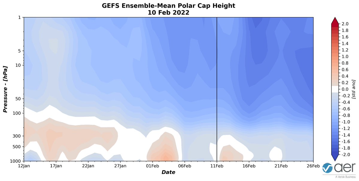
Look at the MJO goes from phase 3 (cold stormy phase) to 4 (warm phase)
GFS is at the 18Z HH 2 for 1 drinks again when it put this out?? Blue line is a sigma 3 - 3.5 strong kelvin wave in phase 3!
One can only pray and wish for such.
_________________
Mugs
AKA:King: Snow Weenie
Self Proclaimed
WINTER 2014-15 : 55.12" +.02 for 6 coatings (avg. 35")
WINTER 2015-16 Total - 29.8" (Avg 35")
WINTER 2016-17 : 39.5" so far

amugs- Advanced Forecaster - Mod

- Posts : 15093
Reputation : 213
Join date : 2013-01-07
Age : 54
Location : Hillsdale,NJ
Re: Long Range Thread 24.0
![]() by heehaw453 Thu Feb 10, 2022 11:48 am
by heehaw453 Thu Feb 10, 2022 11:48 am

heehaw453- Advanced Forecaster
- Posts : 3906
Reputation : 86
Join date : 2014-01-20
Location : Bedminster Township, PA Elevation 600' ASL
Re: Long Range Thread 24.0
![]() by sroc4 Thu Feb 10, 2022 12:32 pm
by sroc4 Thu Feb 10, 2022 12:32 pm
_________________
"In weather and in life, there's no winning and losing; there's only winning and learning."
WINTER 2012/2013 TOTALS 43.65"WINTER 2017/2018 TOTALS 62.85" WINTER 2022/2023 TOTALS 4.9"
WINTER 2013/2014 TOTALS 64.85"WINTER 2018/2019 TOTALS 14.25" WINTER 2023/2024 TOTALS 13.1"
WINTER 2014/2015 TOTALS 71.20"WINTER 2019/2020 TOTALS 6.35"
WINTER 2015/2016 TOTALS 35.00"WINTER 2020/2021 TOTALS 37.75"
WINTER 2016/2017 TOTALS 42.25"WINTER 2021/2022 TOTALS 31.65"
sroc4- Admin
- Posts : 8331
Reputation : 301
Join date : 2013-01-07
Location : Wading River, LI
Re: Long Range Thread 24.0
![]() by jmanley32 Thu Feb 10, 2022 1:04 pm
by jmanley32 Thu Feb 10, 2022 1:04 pm
Gave myself a little break, no SCI on this potential event? Or is that now also a curse that you guys stopped lol. It would be nice to see some snow again just blah here.sroc4 wrote:Im also not a huge fan of the positioning of the upper level JS across guidance. It would suggest the LP center should remain further offshore. This is; however, as is currently modeled. I personally do not believe this is a dead threat at all. There is not much of a timing shift needed to the current key players that could easily re-shuffle things and lead to a big change at the surface. Euro up in about 15 mins or so.

jmanley32- Senior Enthusiast
- Posts : 20517
Reputation : 108
Join date : 2013-12-12
Age : 42
Location : Yonkers, NY
Re: Long Range Thread 24.0
![]() by phil155 Thu Feb 10, 2022 1:39 pm
by phil155 Thu Feb 10, 2022 1:39 pm
phil155- Pro Enthusiast
- Posts : 475
Reputation : 4
Join date : 2019-12-16
mmanisca likes this post
Re: Long Range Thread 24.0
![]() by sroc4 Thu Feb 10, 2022 1:52 pm
by sroc4 Thu Feb 10, 2022 1:52 pm
The ceiling for me, for now, has dropped a bit, but a good 2-4"/3-6" event is still on the table. Again things are not that far away from this happening. Might not though.
_________________
"In weather and in life, there's no winning and losing; there's only winning and learning."
WINTER 2012/2013 TOTALS 43.65"WINTER 2017/2018 TOTALS 62.85" WINTER 2022/2023 TOTALS 4.9"
WINTER 2013/2014 TOTALS 64.85"WINTER 2018/2019 TOTALS 14.25" WINTER 2023/2024 TOTALS 13.1"
WINTER 2014/2015 TOTALS 71.20"WINTER 2019/2020 TOTALS 6.35"
WINTER 2015/2016 TOTALS 35.00"WINTER 2020/2021 TOTALS 37.75"
WINTER 2016/2017 TOTALS 42.25"WINTER 2021/2022 TOTALS 31.65"
sroc4- Admin
- Posts : 8331
Reputation : 301
Join date : 2013-01-07
Location : Wading River, LI
Re: Long Range Thread 24.0
![]() by moleson Thu Feb 10, 2022 2:29 pm
by moleson Thu Feb 10, 2022 2:29 pm
phil155 wrote:I think this thread slowing down is a sure sign the threat is lessening quite a bit. I am not totally discounting it as I am having a party Sunday so if there is any way at all the threat can return it will
I think you have mentioned in every post that you are having a party Sunday. Hope it is fun.

moleson- Posts : 32
Reputation : 0
Join date : 2013-01-07
Re: Long Range Thread 24.0
![]() by Irish Thu Feb 10, 2022 2:42 pm
by Irish Thu Feb 10, 2022 2:42 pm
moleson wrote:phil155 wrote:I think this thread slowing down is a sure sign the threat is lessening quite a bit. I am not totally discounting it as I am having a party Sunday so if there is any way at all the threat can return it will
I think you have mentioned in every post that you are having a party Sunday. Hope it is fun.
Without question! It's like groundhog day. Dude is pumped about the upcoming party! I'm having some FOMO over it.
Irish- Pro Enthusiast
- Posts : 788
Reputation : 19
Join date : 2019-01-16
Age : 45
Location : Old Bridge, NJ
crippo84 likes this post
Re: Long Range Thread 24.0
![]() by rb924119 Thu Feb 10, 2022 2:44 pm
by rb924119 Thu Feb 10, 2022 2:44 pm
rb924119- Meteorologist
- Posts : 6890
Reputation : 194
Join date : 2013-02-06
Age : 32
Location : Greentown, Pa
dolphins222, dkodgis and Irish like this post
Re: Long Range Thread 24.0
![]() by Irish Thu Feb 10, 2022 2:48 pm
by Irish Thu Feb 10, 2022 2:48 pm
Irish- Pro Enthusiast
- Posts : 788
Reputation : 19
Join date : 2019-01-16
Age : 45
Location : Old Bridge, NJ
Re: Long Range Thread 24.0
![]() by heehaw453 Thu Feb 10, 2022 3:02 pm
by heehaw453 Thu Feb 10, 2022 3:02 pm
rb924119 wrote:Can’t understand all the talk of “winter cancel” from other places. I’m doubling down on my call for March - it looks quite January-esque to me with respect to H5. In my opinion, the MJO is going to pull the same stunt that it did in December, though on the opposite side of the world. I think this MJO pulse is going to be stuck in Phase 2/3 for a while (several weeks), which bodes well for our March prospects (in addition to other factors that I’m looking at. It’s what happens after that that’s going to be interesting from a meteorological perspective. My earlier call for a west-based NAO to develop in March *might be* a little too fast, and it may hold off until late-month (this requires further thought over coming days), but I do like my initial call for an ugly and unsettled opening to April. The pattern will flip in April, and once it does, it’s going to get warm in a hurry. But when that flip should occur also requires further hypothesizing. That said, I also like the initial idea of an early and fast start to the severe weather season for the CONUS, mainly once we get to April, but this should also prevent any early-season tropical development, at least anywhere near the mainland U.S. I’ll add further insights into the thoughts that require more brainpower at some point haha
I do think interior may have some opportunities after first week of March as the AO heights rise towards end February and the blocking not as important with shorter wavelengths in March. But I don't think it'll help coastal plain as it's bit too late in the game for them w/out blocking in beginning of month.
heehaw453- Advanced Forecaster
- Posts : 3906
Reputation : 86
Join date : 2014-01-20
Location : Bedminster Township, PA Elevation 600' ASL
Re: Long Range Thread 24.0
![]() by sroc4 Thu Feb 10, 2022 3:06 pm
by sroc4 Thu Feb 10, 2022 3:06 pm
Irish wrote:Seems as though we can kiss Sunday's storm goodbye, as it'll be OTS and Spring arrives next Thursday with temps into the 60s.
Don't let your guard down for Sunday just yet Irish. Id give it through tomorrows 12z runs before writing it off. Been doing this too long and seen these things turn around under 72hrs. Upper levels are just too close.
_________________
"In weather and in life, there's no winning and losing; there's only winning and learning."
WINTER 2012/2013 TOTALS 43.65"WINTER 2017/2018 TOTALS 62.85" WINTER 2022/2023 TOTALS 4.9"
WINTER 2013/2014 TOTALS 64.85"WINTER 2018/2019 TOTALS 14.25" WINTER 2023/2024 TOTALS 13.1"
WINTER 2014/2015 TOTALS 71.20"WINTER 2019/2020 TOTALS 6.35"
WINTER 2015/2016 TOTALS 35.00"WINTER 2020/2021 TOTALS 37.75"
WINTER 2016/2017 TOTALS 42.25"WINTER 2021/2022 TOTALS 31.65"
sroc4- Admin
- Posts : 8331
Reputation : 301
Join date : 2013-01-07
Location : Wading River, LI
weatherwatchermom likes this post
Re: Long Range Thread 24.0
![]() by Irish Thu Feb 10, 2022 3:20 pm
by Irish Thu Feb 10, 2022 3:20 pm
sroc4 wrote:Irish wrote:Seems as though we can kiss Sunday's storm goodbye, as it'll be OTS and Spring arrives next Thursday with temps into the 60s.
Don't let your guard down for Sunday just yet Irish. Id give it through tomorrows 12z runs before writing it off. Been doing this too long and seen these things turn around under 72hrs. Upper levels are just too close.
I always have hope! Anytime I post things like above, it's with sarcasm dripping off it.
Irish- Pro Enthusiast
- Posts : 788
Reputation : 19
Join date : 2019-01-16
Age : 45
Location : Old Bridge, NJ
Re: Long Range Thread 24.0
![]() by sroc4 Thu Feb 10, 2022 3:42 pm
by sroc4 Thu Feb 10, 2022 3:42 pm
Irish wrote:sroc4 wrote:Irish wrote:Seems as though we can kiss Sunday's storm goodbye, as it'll be OTS and Spring arrives next Thursday with temps into the 60s.
Don't let your guard down for Sunday just yet Irish. Id give it through tomorrows 12z runs before writing it off. Been doing this too long and seen these things turn around under 72hrs. Upper levels are just too close.
I always have hope! Anytime I post things like above, it's with sarcasm dripping off it.
Understood. Dripping with sarcasm and covered in the reverse jinx
_________________
"In weather and in life, there's no winning and losing; there's only winning and learning."
WINTER 2012/2013 TOTALS 43.65"WINTER 2017/2018 TOTALS 62.85" WINTER 2022/2023 TOTALS 4.9"
WINTER 2013/2014 TOTALS 64.85"WINTER 2018/2019 TOTALS 14.25" WINTER 2023/2024 TOTALS 13.1"
WINTER 2014/2015 TOTALS 71.20"WINTER 2019/2020 TOTALS 6.35"
WINTER 2015/2016 TOTALS 35.00"WINTER 2020/2021 TOTALS 37.75"
WINTER 2016/2017 TOTALS 42.25"WINTER 2021/2022 TOTALS 31.65"
sroc4- Admin
- Posts : 8331
Reputation : 301
Join date : 2013-01-07
Location : Wading River, LI
weatherwatchermom and Irish like this post
Re: Long Range Thread 24.0
![]() by heehaw453 Thu Feb 10, 2022 5:40 pm
by heehaw453 Thu Feb 10, 2022 5:40 pm

heehaw453- Advanced Forecaster
- Posts : 3906
Reputation : 86
Join date : 2014-01-20
Location : Bedminster Township, PA Elevation 600' ASL
Re: Long Range Thread 24.0
![]() by amugs Thu Feb 10, 2022 8:51 pm
by amugs Thu Feb 10, 2022 8:51 pm
_________________
Mugs
AKA:King: Snow Weenie
Self Proclaimed
WINTER 2014-15 : 55.12" +.02 for 6 coatings (avg. 35")
WINTER 2015-16 Total - 29.8" (Avg 35")
WINTER 2016-17 : 39.5" so far
amugs- Advanced Forecaster - Mod
- Posts : 15093
Reputation : 213
Join date : 2013-01-07
Age : 54
Location : Hillsdale,NJ
Re: Long Range Thread 24.0
![]() by SENJsnowman Fri Feb 11, 2022 6:26 am
by SENJsnowman Fri Feb 11, 2022 6:26 am
Make no mistake, the 18z and 00z runs did NOT walk the storm back towards the coast as I kinda suspected (and hoped!) they would, and nothing has shown more than 2-4" at the coast for this storm since like 12z on Wednesday. So as of now, no reason to think that there is any real upside potential for even a mothra-size storm or better.
Or is there?
I am still a bit optimistic that the NAM has been consistently getting just a bit juicier as it has moved into in range, and the Euro and GFS both had a higher qpf this morning than they did last night, so maybe we still have a slight maybe.
That latest NAM run though...I would like to see that trend continue for the 12z run.
GFS- the least juiced of the 3

The Euro has quietly kept the precip closer to the coast all week i'd say

And the NAM, yeah, I wanna see how this progresses for at least 1 more run. I mean we are still 48+ hrs out...

SENJsnowman- Senior Enthusiast
- Posts : 1186
Reputation : 61
Join date : 2017-01-06
Age : 51
Location : Bayville, NJ
Re: Long Range Thread 24.0
![]() by heehaw453 Fri Feb 11, 2022 7:12 am
by heehaw453 Fri Feb 11, 2022 7:12 am
Right now c-2" is what I would expect.
NAM


heehaw453- Advanced Forecaster
- Posts : 3906
Reputation : 86
Join date : 2014-01-20
Location : Bedminster Township, PA Elevation 600' ASL
Page 9 of 21 • 1 ... 6 ... 8, 9, 10 ... 15 ... 21 ![]()
|
|
|