Long Range Thread 24.0
+38
richb521
freezerburn
moleson
WeatherBob
Grselig
essexcountypete
algae888
frank 638
docstox12
jimv45
SENJsnowman
MattyICE
adamfitz1969
Dunnzoo
CPcantmeasuresnow
dsix85
Koroptim
phil155
dkodgis
weatherwatchermom
mmanisca
sroc4
mikeypizano
nutleyblizzard
jmanley32
TheAresian
heehaw453
Snow88
hyde345
Sparky Sparticles
SoulSingMG
aiannone
lglickman1
Irish
rb924119
amugs
SNOW MAN
Frank_Wx
42 posters
Page 2 of 21
Page 2 of 21 •  1, 2, 3 ... 11 ... 21
 Re: Long Range Thread 24.0
amugs wrote:
Sparky models have trended much cooler with the pattern Thurs and Fri. Advertising 50's last week now 40ish. This storm and the E NAO have been a help as well as the EPO and PNA rebuilding.
So, so far still rain over the NYC area? Good. Our cars are so plowed & snowblowered under we usually just wait and let nature take its course. One of the few good qualities of city living - you can walk everywhere and leave the car where it is for a week if you have to, take a bus, cab or light rail if you need to travel anywhere.
PS - For now I'm ignoring those maps showing snow that just posted. I really *want* this to be rain, but now I see I shouldn't be too surprised if it isn't.
Sparky Sparticles- Posts : 124
Join date : 2014-02-11
 Re: Long Range Thread 24.0
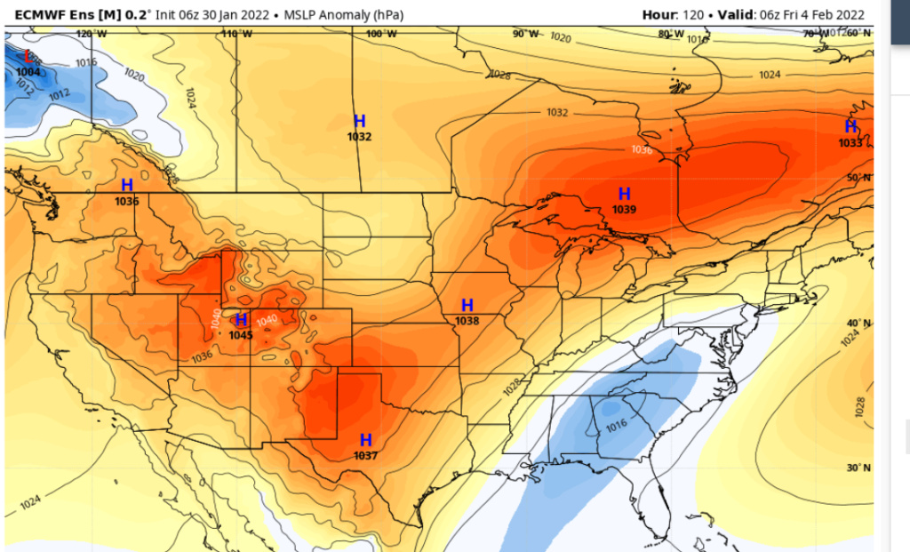
Watch the ensembles for Friday threat window. The EPS continues to show a more favorable look for those NW of I95 with banana building in. I95 battleground, SE of I95 probably going to be tough. I would like to see High pressure oozing down a bit faster for the I95 to have a legit shot. That maybe a function of how strong low pressure is along the front. The stronger it is the more likely cold air is delayed. It is February which is peak climo for I95 and that banana high look is one that will deliver some good cold, so definitely have to watch it.

heehaw453- Advanced Forecaster

- Posts : 3906
Join date : 2014-01-20
 Re: Long Range Thread 24.0
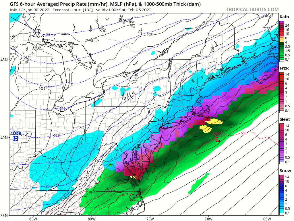
I think trying to get to an all-snow scenario to play out on Friday will be an uphill battle but not impossible. Below is a look of the EURO upper air map valid for Thursday afternoon. Our storm of interest is going to form somewhere in the southeast, but exactly where will be key for us. A surface low that develops too far SW, like Texas, would amplify eastern heights too much (SE Ridge) and cause the storm to cut to our west. A surface low that starts out weaker, meaning less phasing with the southern energies, would develop LATER (say around TN), which keeps the cold air in place for us as the low is likely to pass to our south and east. There's no high latitude blocking, but we do have the northern jet acting as our 'block' with multiple HP's to our north helping to suppress the low and preventing it from cutting too much. You can see these HP's nicely on the MSLP map of the GFS.
Too early to tell what potential snowfall amounts could be. The snowiest models should 8-12" over a large swath of the area. We also have a freezing rain risk, because depending on the exact track of the low, warmer air aloft mixed with freezing temps at the surface could spell trouble.


Too early to tell what potential snowfall amounts could be. The snowiest models should 8-12" over a large swath of the area. We also have a freezing rain risk, because depending on the exact track of the low, warmer air aloft mixed with freezing temps at the surface could spell trouble.


_________________
_______________________________________________________________________________________________________
CLICK HERE to view NJ Strong Snowstorm Classifications
 Re: Long Range Thread 24.0
For whatever it might be worth, TWC currently has me forecasted for a total of 10-17". Is it selfish to hope this storm is mine after the one you all just got?
TheAresian- Senior Enthusiast

- Posts : 145
Reputation : 10
Join date : 2019-11-13
Location : Painted Post, NY
weatherwatchermom likes this post
 Re: Long Range Thread 24.0
GFS keeps correcting South with the boundary. Result of the EPO/WPO Negative tandem push.
I see this correcting more each future run. EPOndid this in 13-14. 14-15 and we had very similar set ups. Super Bowl, end of Feb, beginning of March. Much easier to see evolve than a Millet A or B which are 2x as hard.
I see this correcting more each future run. EPOndid this in 13-14. 14-15 and we had very similar set ups. Super Bowl, end of Feb, beginning of March. Much easier to see evolve than a
 Millet A or B which are 2x as hard.
_________________
Mugs
AKA:King: Snow Weenie
Self Proclaimed
WINTER 2014-15 : 55.12" +.02 for 6 coatings (avg. 35")
WINTER 2015-16 Total - 29.8" (Avg 35")
WINTER 2016-17 : 39.5" so far

amugs- Advanced Forecaster - Mod

- Posts : 15095
Reputation : 213
Join date : 2013-01-07
Age : 54
Location : Hillsdale,NJ
 Re: Long Range Thread 24.0
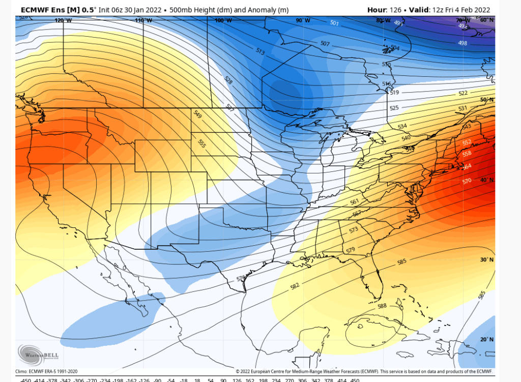
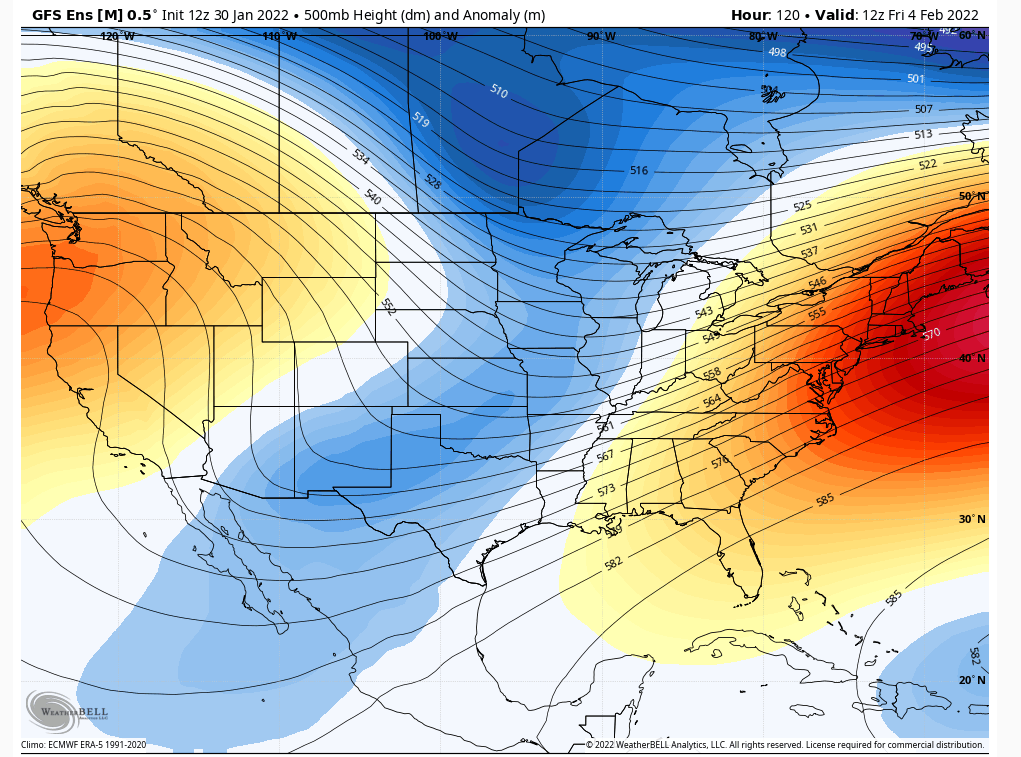
Definitely too early in the game to say much. 06Z EPS took more of a step towards GEFS with stronger and sooner amplification of the low. The WAR (Western Atlantic Ridge) if it pumps too much this will go more inland and develop stronger. This will give most of the area much less frozen threat. Watch the Atlantic ridge IMO.
EPS
GEFS
EPS

GEFS

heehaw453- Advanced Forecaster

- Posts : 3906
Reputation : 86
Join date : 2014-01-20
Location : Bedminster Township, PA Elevation 600' ASL
 Re: Long Range Thread 24.0
heehaw453 wrote:Definitely too early in the game to say much. 06Z EPS took more of a step towards GEFS with stronger and sooner amplification of the low. The WAR (Western Atlantic Ridge) if it pumps too much this will go more inland and develop stronger. This will give most of the area much less frozen threat. Watch the Atlantic ridge IMO.
EPS
GEFS
I’m still recovering from our most recent marathon, so I’ve not looked at this yet, but just seeing these images, I’ll say this: Much like our blizzard, though in the opposite direction, that ridge orientation doesn’t scream “cutter” to me. Just based on this, it looks like there should be very little ridge amplification as the trough shears out, with the southern flank sagging back to the Southwest and the northern stream progressing ahead.
rb924119- Meteorologist

- Posts : 6928
Reputation : 194
Join date : 2013-02-06
Age : 32
Location : Greentown, Pa
CPcantmeasuresnow and heehaw453 like this post
 Re: Long Range Thread 24.0
MJO phase 3 for Feb pattern.
Lots of SWFE riding the barclonic boundary and we'll have many waves come up this.
Remember 94, 14, 15 February's?? This is what it looks like to me at this time.

Heat Miser get back in your hole!!!! And stay there until I tell you to come out! Not Math or anyone else LOL.
SST waters circles in black or phase 2 and 3 in rhe Indian Ocean. Big pattern driver moving fwd.

Maps compliments of 33n Rain, analysis by mooooohahah...me.
Lots of SWFE riding the barclonic boundary and we'll have many waves come up this.
Remember 94, 14, 15 February's?? This is what it looks like to me at this time.

Heat Miser get back in your hole!!!! And stay there until I tell you to come out! Not Math or anyone else LOL.
SST waters circles in black or phase 2 and 3 in rhe Indian Ocean. Big pattern driver moving fwd.

Maps compliments of 33n Rain, analysis by mooooohahah...me.
_________________
Mugs
AKA:King: Snow Weenie
Self Proclaimed
WINTER 2014-15 : 55.12" +.02 for 6 coatings (avg. 35")
WINTER 2015-16 Total - 29.8" (Avg 35")
WINTER 2016-17 : 39.5" so far

amugs- Advanced Forecaster - Mod

- Posts : 15095
Reputation : 213
Join date : 2013-01-07
Age : 54
Location : Hillsdale,NJ
heehaw453 likes this post
 Re: Long Range Thread 24.0
Already looks at another in 5 days huh, im barely recovered from the lack of sleep from this one lol, friends out in eastern CT got nearly 2 ft, I see LI did really well too. I am good with my 9 inches I was able to get right out of my parking spot instead having dig out for hours.
Last edited by jmanley32 on Sun Jan 30, 2022 2:54 pm; edited 1 time in total

jmanley32- Senior Enthusiast

- Posts : 20535
Reputation : 108
Join date : 2013-12-12
Age : 43
Location : Yonkers, NY
 Re: Long Range Thread 24.0
So much for that February torch that all the warm trolls were calling for.amugs wrote:MJO phase 3 for Feb pattern.
Lots of SWFE riding the barclonic boundary and we'll have many waves come up this.
Remember 94, 14, 15 February's?? This is what it looks like to me at this time.
Heat Miser get back in your hole!!!! And stay there until I tell you to come out! Not Math or anyone else LOL.
SST waters circles in black or phase 2 and 3 in rhe Indian Ocean. Big pattern driver moving fwd.
Maps compliments of 33n Rain, analysis by mooooohahah...me.

nutleyblizzard- Senior Enthusiast

- Posts : 1954
Reputation : 41
Join date : 2014-01-30
Age : 58
Location : Nutley, new jersey
amugs likes this post
 Re: Long Range Thread 24.0
Temps crash but we need them 6 hours sooner for anything meaningful in the NYC Metro - HV and NWNJ is icy:


_________________
Mugs
AKA:King: Snow Weenie
Self Proclaimed
WINTER 2014-15 : 55.12" +.02 for 6 coatings (avg. 35")
WINTER 2015-16 Total - 29.8" (Avg 35")
WINTER 2016-17 : 39.5" so far

amugs- Advanced Forecaster - Mod

- Posts : 15095
Reputation : 213
Join date : 2013-01-07
Age : 54
Location : Hillsdale,NJ
 Re: Long Range Thread 24.0
I think the over running will trend south. Gfs has a 1044 high to the north

Snow88- Senior Enthusiast

- Posts : 2193
Reputation : 4
Join date : 2013-01-09
Age : 35
Location : Brooklyn, NY
amugs likes this post
 Re: Long Range Thread 24.0
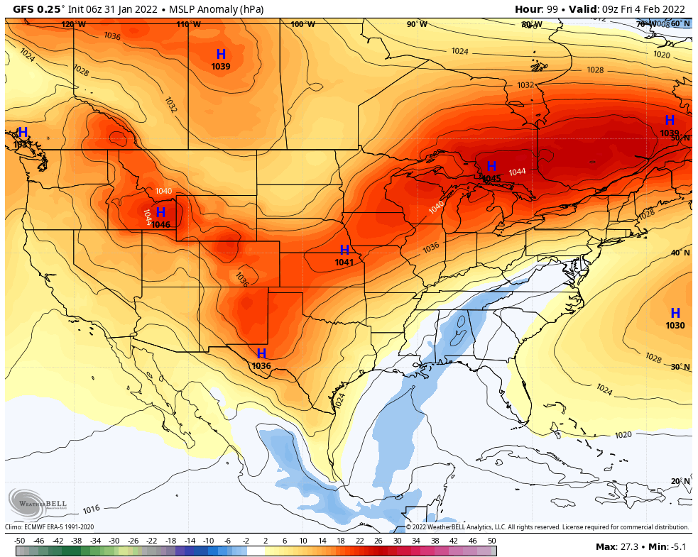
Snow88 wrote:I think the over running will trend south. Gfs has a 1044 high to the north
Take the under on the temps. The 06Z GFS is definitely heading in the right direction for this weekend. This is absolutely not a look of rain for NW95. Give GFS another day to correct, but if this look holds you are going to see much different surface panels with this.
heehaw453- Advanced Forecaster

- Posts : 3906
Reputation : 86
Join date : 2014-01-20
Location : Bedminster Township, PA Elevation 600' ASL
 Re: Long Range Thread 24.0
A banana Nana HP 1048, 1040 HP with N EPO will drill the cold air in. Artic source of cold is dense cold air. It's been -20's in OH CANADA. That will win out.
Rain to ice maybe a good amount to snow set uo Thursday into Friday
Rain to ice maybe a good amount to snow set uo Thursday into Friday
_________________
Mugs
AKA:King: Snow Weenie
Self Proclaimed
WINTER 2014-15 : 55.12" +.02 for 6 coatings (avg. 35")
WINTER 2015-16 Total - 29.8" (Avg 35")
WINTER 2016-17 : 39.5" so far

amugs- Advanced Forecaster - Mod

- Posts : 15095
Reputation : 213
Join date : 2013-01-07
Age : 54
Location : Hillsdale,NJ
 Re: Long Range Thread 24.0
heehaw453 wrote:Snow88 wrote:I think the over running will trend south. Gfs has a 1044 high to the north
Take the under on the temps. The 06Z GFS is definitely heading in the right direction for this weekend. This is absolutely not a look of rain for NW95. Give GFS another day to correct, but if this look holds you are going to see much different surface panels with this.
Again follow the ally of white on this map. That's your weakness where the LP will usually follow if weak.
_________________
Mugs
AKA:King: Snow Weenie
Self Proclaimed
WINTER 2014-15 : 55.12" +.02 for 6 coatings (avg. 35")
WINTER 2015-16 Total - 29.8" (Avg 35")
WINTER 2016-17 : 39.5" so far

amugs- Advanced Forecaster - Mod

- Posts : 15095
Reputation : 213
Join date : 2013-01-07
Age : 54
Location : Hillsdale,NJ
 Re: Long Range Thread 24.0
06z GFS came in wayyy colder than previous runs for the late-week system. 

SoulSingMG- Senior Enthusiast

- Posts : 2853
Reputation : 74
Join date : 2013-12-11
Location : Long Island City, NY
amugs likes this post
 Re: Long Range Thread 24.0
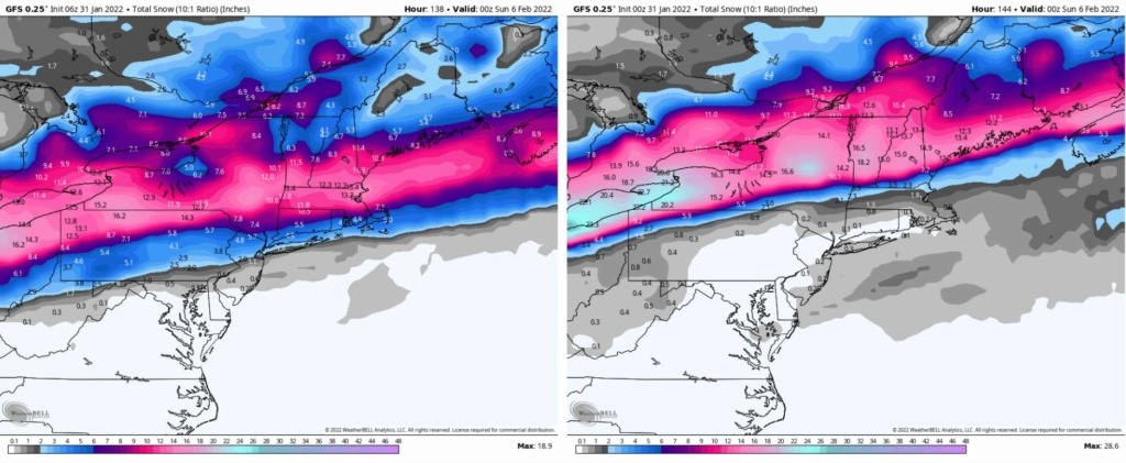
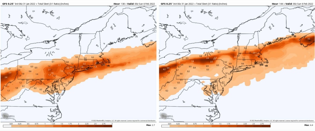
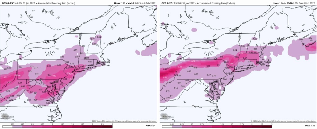
I'm presuming the snow map showing 12+ is not accurate since there's rain and what looks like sig ice. Not good have ice then snow. I believe snow map shows all of those of tropical tidbits. Anyone have the precip breakdown from wxbell?SoulSingMG wrote:06z GFS came in wayyy colder than previous runs for the late-week system.

jmanley32- Senior Enthusiast

- Posts : 20535
Reputation : 108
Join date : 2013-12-12
Age : 43
Location : Yonkers, NY
TheAresian- Senior Enthusiast

- Posts : 145
Reputation : 10
Join date : 2019-11-13
Location : Painted Post, NY
 Re: Long Range Thread 24.0
jmanley32 wrote:I'm presuming the snow map showing 12+ is not accurate since there's rain and what looks like sig ice. Not good have ice then snow. I believe snow map shows all of those of tropical tidbits. Anyone have the precip breakdown from wxbell?SoulSingMG wrote:06z GFS came in wayyy colder than previous runs for the late-week system.
That's correct, Jman. Here's a look at the breakdown of precip types (06z left, 00z right):

SoulSingMG- Senior Enthusiast

- Posts : 2853
Reputation : 74
Join date : 2013-12-11
Location : Long Island City, NY
 Re: Long Range Thread 24.0
The ice comes b4 the snow at least here which is even worse and as soul posted it won't be a foot where ice falls. Not good a half inch ice to over a inch. Ice storm warning anyone? Yikes. Usually that doesn't play out so that's the only hope on the ice.

jmanley32- Senior Enthusiast

- Posts : 20535
Reputation : 108
Join date : 2013-12-12
Age : 43
Location : Yonkers, NY
 Re: Long Range Thread 24.0
I was talking about half an inch of ice on top of whatever snow might be left over from the blizzard. I saw a few postings of 18-20" so I figured a foot leftover might not be unreasonable. No matter what happens, if that map were to verify, it would be a nightmare.
TheAresian- Senior Enthusiast

- Posts : 145
Reputation : 10
Join date : 2019-11-13
Location : Painted Post, NY
 Re: Long Range Thread 24.0
Right lol still have snow. I guess I was only think of roads. Yeah and trees with snow. But I doubt that verifies it keeps trending colder may continue to where ends up be all snow.TheAresian wrote:I was talking about half an inch of ice on top of whatever snow might be left over from the blizzard. I saw a few postings of 18-20" so I figured a foot leftover might not be unreasonable. No matter what happens, if that map were to verify, it would be a nightmare.

jmanley32- Senior Enthusiast

- Posts : 20535
Reputation : 108
Join date : 2013-12-12
Age : 43
Location : Yonkers, NY
 Re: Long Range Thread 24.0
EURO

GFS

There's the difference about 100 miles by a crows flight - 3-4 hours timing.
HP Placement at the same time frame
GFS

Euro

It is after this what the models do - GFS bring it East over Toronto - Euro doesn't go passed HR 90 at 6Z

Tick tick tick

GFS

There's the difference about 100 miles by a crows flight - 3-4 hours timing.
HP Placement at the same time frame
GFS

Euro

It is after this what the models do - GFS bring it East over Toronto - Euro doesn't go passed HR 90 at 6Z

Tick tick tick
_________________
Mugs
AKA:King: Snow Weenie
Self Proclaimed
WINTER 2014-15 : 55.12" +.02 for 6 coatings (avg. 35")
WINTER 2015-16 Total - 29.8" (Avg 35")
WINTER 2016-17 : 39.5" so far

amugs- Advanced Forecaster - Mod

- Posts : 15095
Reputation : 213
Join date : 2013-01-07
Age : 54
Location : Hillsdale,NJ
 Re: Long Range Thread 24.0
Monday next time frame Rb pointed out - BINGO!!


_________________
Mugs
AKA:King: Snow Weenie
Self Proclaimed
WINTER 2014-15 : 55.12" +.02 for 6 coatings (avg. 35")
WINTER 2015-16 Total - 29.8" (Avg 35")
WINTER 2016-17 : 39.5" so far

amugs- Advanced Forecaster - Mod

- Posts : 15095
Reputation : 213
Join date : 2013-01-07
Age : 54
Location : Hillsdale,NJ
 Re: Long Range Thread 24.0
amugs wrote:Monday next time frame Rb pointed out - BINGO!!
Shouldn't we get though Friday storm first?

mikeypizano- Pro Enthusiast

- Posts : 1118
Reputation : 66
Join date : 2017-01-05
Age : 35
Location : Wilkes-Barre/Scranton, PA
amugs likes this post
 Re: Long Range Thread 24.0
mikeypizano wrote:amugs wrote:Monday next time frame Rb pointed out - BINGO!!
Shouldn't we get though Friday storm first?
Nothing wrong with pointing out things on the table in the LR thread
_________________
"In weather and in life, there's no winning and losing; there's only winning and learning."
WINTER 2012/2013 TOTALS 43.65"WINTER 2017/2018 TOTALS 62.85" WINTER 2022/2023 TOTALS 4.9"
WINTER 2013/2014 TOTALS 64.85"WINTER 2018/2019 TOTALS 14.25" WINTER 2023/2024 TOTALS 13.1"
WINTER 2014/2015 TOTALS 71.20"WINTER 2019/2020 TOTALS 6.35"
WINTER 2015/2016 TOTALS 35.00"WINTER 2020/2021 TOTALS 37.75"
WINTER 2016/2017 TOTALS 42.25"WINTER 2021/2022 TOTALS 31.65"

sroc4- Admin

- Posts : 8354
Reputation : 302
Join date : 2013-01-07
Location : Wading River, LI
mmanisca likes this post
 Re: Long Range Thread 24.0
sroc4 wrote:mikeypizano wrote:amugs wrote:Monday next time frame Rb pointed out - BINGO!!
Shouldn't we get though Friday storm first?
Nothing wrong with pointing out things on the table in the LR thread
But doesn't it get skewed from the first system?

mikeypizano- Pro Enthusiast

- Posts : 1118
Reputation : 66
Join date : 2017-01-05
Age : 35
Location : Wilkes-Barre/Scranton, PA
Page 2 of 21 •  1, 2, 3 ... 11 ... 21
Page 2 of 21
Permissions in this forum:
You cannot reply to topics in this forum|
|
|

 Home
Home