
 Search
Long Range Thread 24.0
Page 12 of 21 •  1 ... 7 ... 11, 12, 13 ... 16 ... 21
 ![]()
Re: Long Range Thread 24.0
![]() by rb924119 Sun Feb 13, 2022 10:10 am
by rb924119 Sun Feb 13, 2022 10:10 am
heehaw453 wrote:I believe NJ coast is done for the season IMO outside of minor accumulations. This is way too hostile to overcome for anything meaningful. It basically means cold air is going to be bottled up in Canada and not push down into US. March I expect that to relax a bit and then interior may have "some shots" probably after 1st week of March. I-95 maybe can also be involved in March, but that's a big IF.

Heehaw, the AO is not the powerhouse it used to be. Think about it, the AO was strongly positive for the last six weeks, yet we managed to average 2-4 degrees below average during that stretch. Meanwhile, the only time it went negative, our temperatures spiked in both the second half of December, as well as more recently in this six-week stretch . There are several other examples of this in recent years . The Pacific domain has become much more important to governing our weather. So just because this teleconnection is hostile, I wouldn’t discount the rest of our Winter Season.
rb924119- Meteorologist

- Posts : 6889
Join date : 2013-02-06
amugs likes this post
dkodgis- Senior Enthusiast

- Posts : 2493
Join date : 2013-12-29
Re: Long Range Thread 24.0
![]() by amugs Sun Feb 13, 2022 10:17 am
by amugs Sun Feb 13, 2022 10:17 am
From Joe D at Wx Bell Maps
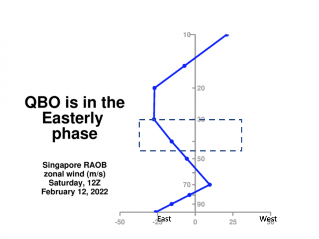
ENSO 1-3 zoomed in - COLD East Based Nina

_________________
Mugs
AKA:King: Snow Weenie
Self Proclaimed
WINTER 2014-15 : 55.12" +.02 for 6 coatings (avg. 35")
WINTER 2015-16 Total - 29.8" (Avg 35")
WINTER 2016-17 : 39.5" so far

amugs- Advanced Forecaster - Mod

- Posts : 15093
Reputation : 213
Join date : 2013-01-07
Age : 54
Location : Hillsdale,NJ
rb924119 and SENJsnowman like this post
Re: Long Range Thread 24.0
![]() by amugs Sun Feb 13, 2022 10:19 am
by amugs Sun Feb 13, 2022 10:19 am
_________________
Mugs
AKA:King: Snow Weenie
Self Proclaimed
WINTER 2014-15 : 55.12" +.02 for 6 coatings (avg. 35")
WINTER 2015-16 Total - 29.8" (Avg 35")
WINTER 2016-17 : 39.5" so far
amugs- Advanced Forecaster - Mod
- Posts : 15093
Reputation : 213
Join date : 2013-01-07
Age : 54
Location : Hillsdale,NJ
rb924119 likes this post
Re: Long Range Thread 24.0
![]() by amugs Sun Feb 13, 2022 10:23 am
by amugs Sun Feb 13, 2022 10:23 am
Could be a result of Strat warm flux 1 and 2 from MJO phase 4 then 5 in Feb then March
_________________
Mugs
AKA:King: Snow Weenie
Self Proclaimed
WINTER 2014-15 : 55.12" +.02 for 6 coatings (avg. 35")
WINTER 2015-16 Total - 29.8" (Avg 35")
WINTER 2016-17 : 39.5" so far
amugs- Advanced Forecaster - Mod
- Posts : 15093
Reputation : 213
Join date : 2013-01-07
Age : 54
Location : Hillsdale,NJ
Re: Long Range Thread 24.0
![]() by rb924119 Sun Feb 13, 2022 10:30 am
by rb924119 Sun Feb 13, 2022 10:30 am
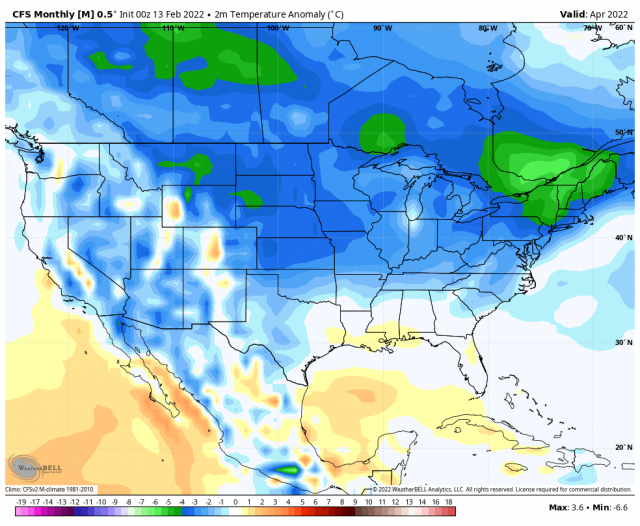
amugs wrote:May not be over in April in the North Country if this model has any clue!!
Could be a result of Strat warm flux 1 and 2 from MJO phase 4 then 5 in Feb then March
Note my west-based -NAO signature showing up here. I do think we see it return, but I just haven’t sat down to try to figure out exactly when. I’m torn between seeing it return in tandem with the March flip to cold again, or if it holds off a bit longer. Either way, it at least shows that those long-standing ideas do actually have merit, so I’m content haha my horse is still in the race lmao
rb924119- Meteorologist
- Posts : 6889
Reputation : 194
Join date : 2013-02-06
Age : 32
Location : Greentown, Pa
Re: Long Range Thread 24.0
![]() by heehaw453 Sun Feb 13, 2022 10:39 am
by heehaw453 Sun Feb 13, 2022 10:39 am
rb924119 wrote:heehaw453 wrote:I believe NJ coast is done for the season IMO outside of minor accumulations. This is way too hostile to overcome for anything meaningful. It basically means cold air is going to be bottled up in Canada and not push down into US. March I expect that to relax a bit and then interior may have "some shots" probably after 1st week of March. I-95 maybe can also be involved in March, but that's a big IF.
Heehaw, the AO is not the powerhouse it used to be. Think about it, the AO was strongly positive for the last six weeks, yet we managed to average 2-4 degrees below average during that stretch. Meanwhile, the only time it went negative, our temperatures spiked in both the second half of December, as well as more recently in this six-week stretch . There are several other examples of this in recent years . The Pacific domain has become much more important to governing our weather. So just because this teleconnection is hostile, I wouldn’t discount the rest of our Winter Season.
That is true Rb. I should be clear that I have minimal optimism for remainder of February for us all w.r.t. snowfall prospects. I'm really speaking of March to potentially reload.
It's unfortunately not just about the cold as you know. It's about the progressive pattern too that has enabled the interior to be in snow deficits. The NAO has been consistently positive since December. Everything becomes thread the needle with these storms as we hope the trough tilts in time for a hit. Doesn't happen and unlikely to until March when amplification becomes quicker and we don't need the NAO "as much". My guess is the AO/NAO goes more toward neutral in March which opens the door "a bit" and since there is good base cold in Canada then some of that will leak down especially with some EPO/PNA cooperation. In terms of coastal areas, I just don't think March pattern is going to be good enough to overcome climatology. It's very difficult in March for immediate coast even in an ideal pattern.
As an aside last winter we had a terrible Pacific which resulted in a bad January due to pac air. But then as the AO continued to stay negative and the PAC relaxed a bit we got some really good blocking that enabled the interior to do very well while the shore just missed out as temps were a hair too warm. It was close for the shore last year, a lot more so then people may give credit for.
But I'm rooting for more snow and that goes w/out saying. If I'm wrong and March rocks, then I'll be ecstatic as I don't want this to be closing acts.
heehaw453- Advanced Forecaster

- Posts : 3906
Reputation : 86
Join date : 2014-01-20
Location : Bedminster Township, PA Elevation 600' ASL
Re: Long Range Thread 24.0
![]() by amugs Sun Feb 13, 2022 1:14 pm
by amugs Sun Feb 13, 2022 1:14 pm

_________________
Mugs
AKA:King: Snow Weenie
Self Proclaimed
WINTER 2014-15 : 55.12" +.02 for 6 coatings (avg. 35")
WINTER 2015-16 Total - 29.8" (Avg 35")
WINTER 2016-17 : 39.5" so far
amugs- Advanced Forecaster - Mod
- Posts : 15093
Reputation : 213
Join date : 2013-01-07
Age : 54
Location : Hillsdale,NJ
rb924119 likes this post
Re: Long Range Thread 24.0
![]() by sroc4 Sun Feb 13, 2022 1:28 pm
by sroc4 Sun Feb 13, 2022 1:28 pm
amugs wrote:Rb for you......
A lot happing in this one image. Quite the ReX block, 50/50 ULL and attempted negative NAO
_________________
"In weather and in life, there's no winning and losing; there's only winning and learning."
WINTER 2012/2013 TOTALS 43.65"WINTER 2017/2018 TOTALS 62.85" WINTER 2022/2023 TOTALS 4.9"
WINTER 2013/2014 TOTALS 64.85"WINTER 2018/2019 TOTALS 14.25" WINTER 2023/2024 TOTALS 13.1"
WINTER 2014/2015 TOTALS 71.20"WINTER 2019/2020 TOTALS 6.35"
WINTER 2015/2016 TOTALS 35.00"WINTER 2020/2021 TOTALS 37.75"
WINTER 2016/2017 TOTALS 42.25"WINTER 2021/2022 TOTALS 31.65"

sroc4- Admin

- Posts : 8331
Reputation : 301
Join date : 2013-01-07
Location : Wading River, LI
amugs and rb924119 like this post
Re: Long Range Thread 24.0
![]() by rb924119 Mon Feb 14, 2022 12:57 am
by rb924119 Mon Feb 14, 2022 12:57 am
heehaw453 wrote:rb924119 wrote:heehaw453 wrote:I believe NJ coast is done for the season IMO outside of minor accumulations. This is way too hostile to overcome for anything meaningful. It basically means cold air is going to be bottled up in Canada and not push down into US. March I expect that to relax a bit and then interior may have "some shots" probably after 1st week of March. I-95 maybe can also be involved in March, but that's a big IF.
Heehaw, the AO is not the powerhouse it used to be. Think about it, the AO was strongly positive for the last six weeks, yet we managed to average 2-4 degrees below average during that stretch. Meanwhile, the only time it went negative, our temperatures spiked in both the second half of December, as well as more recently in this six-week stretch . There are several other examples of this in recent years . The Pacific domain has become much more important to governing our weather. So just because this teleconnection is hostile, I wouldn’t discount the rest of our Winter Season.
That is true Rb. I should be clear that I have minimal optimism for remainder of February for us all w.r.t. snowfall prospects. I'm really speaking of March to potentially reload.
It's unfortunately not just about the cold as you know. It's about the progressive pattern too that has enabled the interior to be in snow deficits. The NAO has been consistently positive since December. Everything becomes thread the needle with these storms as we hope the trough tilts in time for a hit. Doesn't happen and unlikely to until March when amplification becomes quicker and we don't need the NAO "as much". My guess is the AO/NAO goes more toward neutral in March which opens the door "a bit" and since there is good base cold in Canada then some of that will leak down especially with some EPO/PNA cooperation. In terms of coastal areas, I just don't think March pattern is going to be good enough to overcome climatology. It's very difficult in March for immediate coast even in an ideal pattern.
As an aside last winter we had a terrible Pacific which resulted in a bad January due to pac air. But then as the AO continued to stay negative and the PAC relaxed a bit we got some really good blocking that enabled the interior to do very well while the shore just missed out as temps were a hair too warm. It was close for the shore last year, a lot more so then people may give credit for.
But I'm rooting for more snow and that goes w/out saying. If I'm wrong and March rocks, then I'll be ecstatic as I don't want this to be closing acts.
Some respectful debate here, heehaw, but EVERY storm is “ thread the needle”. If they weren’t, coastal averages would be substantially higher than the 20-40” range that we have across our coastal regions. And, the argument about the progressive pattern isn’t exactly a strong one either, since we were able to produce not one, but two verified blizzards for parts of our forum with snowfall totals in excess of a foot within the span of three weeks. Even if we had blocking, there’s no guarantee that that would have happened. What changed? The Pacific became much more cooperative with respect to its alignment while the Atlantic and Arctic domains remained relatively unchanged and hostile.
Regarding your thoughts about the upcoming pattern, it is admittedly hard to go against climatology. I grant you that. But I will respectfully disagree with you haha the number one ingredient for snow is cold, and in my opinion, we will have it for most, if not all of the month, with a return to a time-mean below-average regime during the first week. Even the last three to four days of February are shaping up to yield a classic gradient pattern, which can be extremely productive if you’re just north of the lower-level boundaries, and given the pattern, I believe that the models should correct colder for the last few days of February as time progresses. So I’m not writing this month off either.
rb924119- Meteorologist
- Posts : 6889
Reputation : 194
Join date : 2013-02-06
Age : 32
Location : Greentown, Pa
Re: Long Range Thread 24.0
![]() by rb924119 Mon Feb 14, 2022 2:55 am
by rb924119 Mon Feb 14, 2022 2:55 am

rb924119- Meteorologist
- Posts : 6889
Reputation : 194
Join date : 2013-02-06
Age : 32
Location : Greentown, Pa
dolphins222, SENJsnowman and Irish like this post
Re: Long Range Thread 24.0
![]() by heehaw453 Mon Feb 14, 2022 7:10 am
by heehaw453 Mon Feb 14, 2022 7:10 am
rb924119 wrote:heehaw453 wrote:rb924119 wrote:heehaw453 wrote:I believe NJ coast is done for the season IMO outside of minor accumulations. This is way too hostile to overcome for anything meaningful. It basically means cold air is going to be bottled up in Canada and not push down into US. March I expect that to relax a bit and then interior may have "some shots" probably after 1st week of March. I-95 maybe can also be involved in March, but that's a big IF.
Heehaw, the AO is not the powerhouse it used to be. Think about it, the AO was strongly positive for the last six weeks, yet we managed to average 2-4 degrees below average during that stretch. Meanwhile, the only time it went negative, our temperatures spiked in both the second half of December, as well as more recently in this six-week stretch . There are several other examples of this in recent years . The Pacific domain has become much more important to governing our weather. So just because this teleconnection is hostile, I wouldn’t discount the rest of our Winter Season.
That is true Rb. I should be clear that I have minimal optimism for remainder of February for us all w.r.t. snowfall prospects. I'm really speaking of March to potentially reload.
It's unfortunately not just about the cold as you know. It's about the progressive pattern too that has enabled the interior to be in snow deficits. The NAO has been consistently positive since December. Everything becomes thread the needle with these storms as we hope the trough tilts in time for a hit. Doesn't happen and unlikely to until March when amplification becomes quicker and we don't need the NAO "as much". My guess is the AO/NAO goes more toward neutral in March which opens the door "a bit" and since there is good base cold in Canada then some of that will leak down especially with some EPO/PNA cooperation. In terms of coastal areas, I just don't think March pattern is going to be good enough to overcome climatology. It's very difficult in March for immediate coast even in an ideal pattern.
As an aside last winter we had a terrible Pacific which resulted in a bad January due to pac air. But then as the AO continued to stay negative and the PAC relaxed a bit we got some really good blocking that enabled the interior to do very well while the shore just missed out as temps were a hair too warm. It was close for the shore last year, a lot more so then people may give credit for.
But I'm rooting for more snow and that goes w/out saying. If I'm wrong and March rocks, then I'll be ecstatic as I don't want this to be closing acts.
Some respectful debate here, heehaw, but EVERY storm is “ thread the needle”. If they weren’t, coastal averages would be substantially higher than the 20-40” range that we have across our coastal regions. And, the argument about the progressive pattern isn’t exactly a strong one either, since we were able to produce not one, but two verified blizzards for parts of our forum with snowfall totals in excess of a foot within the span of three weeks. Even if we had blocking, there’s no guarantee that that would have happened. What changed? The Pacific became much more cooperative with respect to its alignment while the Atlantic and Arctic domains remained relatively unchanged and hostile.
Regarding your thoughts about the upcoming pattern, it is admittedly hard to go against climatology. I grant you that. But I will respectfully disagree with you haha the number one ingredient for snow is cold, and in my opinion, we will have it for most, if not all of the month, with a return to a time-mean below-average regime during the first week. Even the last three to four days of February are shaping up to yield a classic gradient pattern, which can be extremely productive if you’re just north of the lower-level boundaries, and given the pattern, I believe that the models should correct colder for the last few days of February as time progresses. So I’m not writing this month off either.
First off appreciate the discussion on this!
1/ The upstream pattern (PNA domain) is definitely not progressive, LOL. We have troughs digging into the GOM. It's the downstream Atlantic that is progressive. Now that calls to mind the debate some folks have on the weight of each teleconnection. Truth is they all are important to a degree, but at a higher level my belief is that from say DC, PHL, NYC and their surrounding NW suburbs large scale events (>= 10") are most heavily correlated to the AO/NAO state. It comes down to latitude/longitude (especially in January and February) which translates to time and trajectory. Eastern zones as is clearly demonstrated this year had the longitude part just fine. The latitude part wasn't needed as much as the PNA ridging allowed for enough amplification to spin up the robust storm and the EPO dumped in the cold. Now there will be exceptions to this in DC, PHL, and NYC and it's a correlation not causality obviously. So I can work on getting that data, but it's pretty convincing I believe. It's one of the big reasons why when the NAM state went POS and stayed that way I was skeptical on AN snowfall for I-95 and the interior. But that's easy for me to do after the fact. Your call was in November when folks like myself were thinking December would be good not realizing the PNA state would be as absurd as it was.
2/ EPS def shows this possibility of a stalled baroclinic zone towards latter Feb, but just think if we get another crack at something it's going to be after 1st week of March.
Let's hope we pad the totals!
heehaw453- Advanced Forecaster
- Posts : 3906
Reputation : 86
Join date : 2014-01-20
Location : Bedminster Township, PA Elevation 600' ASL
Re: Long Range Thread 24.0
![]() by amugs Mon Feb 14, 2022 7:38 am
by amugs Mon Feb 14, 2022 7:38 am
Gfs much stronger and therefore a Lake's cutter.
Euro much weaker and inland runner.
Who's going to be right this time??
Gfs has in thisnrange made sonmanybwibter storms absolute bombs only to get meh as we draw nearer. Far interior folks keep an eye on this.


_________________
Mugs
AKA:King: Snow Weenie
Self Proclaimed
WINTER 2014-15 : 55.12" +.02 for 6 coatings (avg. 35")
WINTER 2015-16 Total - 29.8" (Avg 35")
WINTER 2016-17 : 39.5" so far
amugs- Advanced Forecaster - Mod
- Posts : 15093
Reputation : 213
Join date : 2013-01-07
Age : 54
Location : Hillsdale,NJ
Re: Long Range Thread 24.0
![]() by amugs Mon Feb 14, 2022 1:13 pm
by amugs Mon Feb 14, 2022 1:13 pm


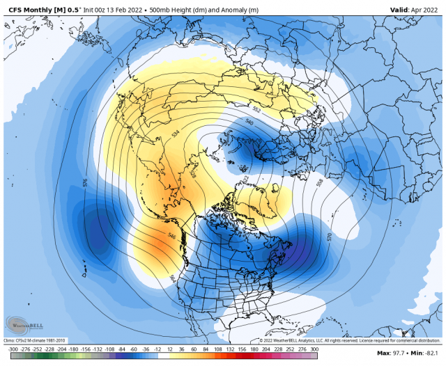
Building the N EPO
_________________
Mugs
AKA:King: Snow Weenie
Self Proclaimed
WINTER 2014-15 : 55.12" +.02 for 6 coatings (avg. 35")
WINTER 2015-16 Total - 29.8" (Avg 35")
WINTER 2016-17 : 39.5" so far
amugs- Advanced Forecaster - Mod
- Posts : 15093
Reputation : 213
Join date : 2013-01-07
Age : 54
Location : Hillsdale,NJ
Re: Long Range Thread 24.0
![]() by rb924119 Mon Feb 14, 2022 1:24 pm
by rb924119 Mon Feb 14, 2022 1:24 pm
heehaw453 wrote:rb924119 wrote:heehaw453 wrote:rb924119 wrote:heehaw453 wrote:I believe NJ coast is done for the season IMO outside of minor accumulations. This is way too hostile to overcome for anything meaningful. It basically means cold air is going to be bottled up in Canada and not push down into US. March I expect that to relax a bit and then interior may have "some shots" probably after 1st week of March. I-95 maybe can also be involved in March, but that's a big IF.
Heehaw, the AO is not the powerhouse it used to be. Think about it, the AO was strongly positive for the last six weeks, yet we managed to average 2-4 degrees below average during that stretch. Meanwhile, the only time it went negative, our temperatures spiked in both the second half of December, as well as more recently in this six-week stretch . There are several other examples of this in recent years . The Pacific domain has become much more important to governing our weather. So just because this teleconnection is hostile, I wouldn’t discount the rest of our Winter Season.
That is true Rb. I should be clear that I have minimal optimism for remainder of February for us all w.r.t. snowfall prospects. I'm really speaking of March to potentially reload.
It's unfortunately not just about the cold as you know. It's about the progressive pattern too that has enabled the interior to be in snow deficits. The NAO has been consistently positive since December. Everything becomes thread the needle with these storms as we hope the trough tilts in time for a hit. Doesn't happen and unlikely to until March when amplification becomes quicker and we don't need the NAO "as much". My guess is the AO/NAO goes more toward neutral in March which opens the door "a bit" and since there is good base cold in Canada then some of that will leak down especially with some EPO/PNA cooperation. In terms of coastal areas, I just don't think March pattern is going to be good enough to overcome climatology. It's very difficult in March for immediate coast even in an ideal pattern.
As an aside last winter we had a terrible Pacific which resulted in a bad January due to pac air. But then as the AO continued to stay negative and the PAC relaxed a bit we got some really good blocking that enabled the interior to do very well while the shore just missed out as temps were a hair too warm. It was close for the shore last year, a lot more so then people may give credit for.
But I'm rooting for more snow and that goes w/out saying. If I'm wrong and March rocks, then I'll be ecstatic as I don't want this to be closing acts.
Some respectful debate here, heehaw, but EVERY storm is “ thread the needle”. If they weren’t, coastal averages would be substantially higher than the 20-40” range that we have across our coastal regions. And, the argument about the progressive pattern isn’t exactly a strong one either, since we were able to produce not one, but two verified blizzards for parts of our forum with snowfall totals in excess of a foot within the span of three weeks. Even if we had blocking, there’s no guarantee that that would have happened. What changed? The Pacific became much more cooperative with respect to its alignment while the Atlantic and Arctic domains remained relatively unchanged and hostile.
Regarding your thoughts about the upcoming pattern, it is admittedly hard to go against climatology. I grant you that. But I will respectfully disagree with you haha the number one ingredient for snow is cold, and in my opinion, we will have it for most, if not all of the month, with a return to a time-mean below-average regime during the first week. Even the last three to four days of February are shaping up to yield a classic gradient pattern, which can be extremely productive if you’re just north of the lower-level boundaries, and given the pattern, I believe that the models should correct colder for the last few days of February as time progresses. So I’m not writing this month off either.
First off appreciate the discussion on this!
1/ The upstream pattern (PNA domain) is definitely not progressive, LOL. We have troughs digging into the GOM. It's the downstream Atlantic that is progressive. Now that calls to mind the debate some folks have on the weight of each teleconnection. Truth is they all are important to a degree, but at a higher level my belief is that from say DC, PHL, NYC and their surrounding NW suburbs large scale events (>= 10") are most heavily correlated to the AO/NAO state. It comes down to latitude/longitude (especially in January and February) which translates to time and trajectory. Eastern zones as is clearly demonstrated this year had the longitude part just fine. The latitude part wasn't needed as much as the PNA ridging allowed for enough amplification to spin up the robust storm and the EPO dumped in the cold. Now there will be exceptions to this in DC, PHL, and NYC and it's a correlation not causality obviously. So I can work on getting that data, but it's pretty convincing I believe. It's one of the big reasons why when the NAM state went POS and stayed that way I was skeptical on AN snowfall for I-95 and the interior. But that's easy for me to do after the fact. Your call was in November when folks like myself were thinking December would be good not realizing the PNA state would be as absurd as it was.
2/ EPS def shows this possibility of a stalled baroclinic zone towards latter Feb, but just think if we get another crack at something it's going to be after 1st week of March.
Let's hope we pad the totals!
I definitely agree with your first couple points, and would be curious to see the statistical breakdown of snowfalls with respect to various teleconnection states/combinations. However, that’s an extremely daunting task lol if anybody following along can contact Don Sutherland from other sites and ask for the stats on, say, 4” 8”, and 12”+ snowfalls for KNYC and the corresponding teleconnection breakdown, he’d have that data readily available. I guess my hesitation comes from my reluctance to analog forecasts. Because no storm or pattern is exactly the same. Yes, I’ve mentioned that certain storms look like others, but those comparisons aren’t used as a part of any forecast, just as an example so others can get an idea of what I’m thinking. That same mentality goes toward teleconnections. Just because we see certain like graphs depicting the sign of a particular teleconnection, it doesn’t mean that the atmosphere will behave that way. That’s why I look at and base analysis strictly on the H5 anomaly structures instead. Because each feature is dynamic and interconnected with everything else. It’s not static.
A great example would be the most recent blizzard. One could make the argument, and I will, that the state of the Atlantic/Arctic domains actually AIDED in allowing that to bring the higher snowfall totals further west than a lot of the modeling was suggesting just a day before the event. The enhancement of the Atlantic ridge allowed the storm track to shift further north and west. Yes, it was a quick mover, but it moved at a higher latitude/further west longitude. If we had the Atlantic/Arctic domain blocking, then it’s my opinion that the storm would have been a slower mover, but probably nothing for us whatsoever, as the entire storm track would have been shifted further south and east. And, without the Pacific help, nothing would have happened whatsoever.
So, while agree that there is certainly a correlation between favorable teleconnections and snowfall, I contend that it’s entirely situationally dependent, and that without a helpful Pacific (PNA/EPO/WPO), it becomes exceedingly difficult to get meaningful snow, as was demonstrated in December. Our weather comes from the west, not the east. And the Pacific is the largest energy input of the globe, so its my opinion that the Pacific domain is the driver, while the others are backseat drivers.
rb924119- Meteorologist
- Posts : 6889
Reputation : 194
Join date : 2013-02-06
Age : 32
Location : Greentown, Pa
JT33 likes this post
Re: Long Range Thread 24.0
![]() by rb924119 Mon Feb 14, 2022 1:25 pm
by rb924119 Mon Feb 14, 2022 1:25 pm
amugs wrote:Its good to see the pattern starting to reload here - it was a few days later and now moving up a tad in time
Building the N EPO
rb924119- Meteorologist
- Posts : 6889
Reputation : 194
Join date : 2013-02-06
Age : 32
Location : Greentown, Pa


rb924119- Meteorologist
- Posts : 6889
Reputation : 194
Join date : 2013-02-06
Age : 32
Location : Greentown, Pa
Re: Long Range Thread 24.0
![]() by heehaw453 Mon Feb 14, 2022 2:09 pm
by heehaw453 Mon Feb 14, 2022 2:09 pm
heehaw453- Advanced Forecaster
- Posts : 3906
Reputation : 86
Join date : 2014-01-20
Location : Bedminster Township, PA Elevation 600' ASL
Re: Long Range Thread 24.0
![]() by sroc4 Mon Feb 14, 2022 2:35 pm
by sroc4 Mon Feb 14, 2022 2:35 pm
heehaw453 wrote:Yeah with Canada having ample cold air the -EPO would bleed down cold as the SE ridge gets pushed on by TPV in Greenland. I think that could happen in March but not February because I've seen this look get pushed back several times. And my concern with March is when it does actually happen it maybe too late for a lot of folksBut let's see if this starts building more consistency and alignment as we get within say 7 days. Because if it does manifest itself by end February, I-95 would be in the game for its effects.
Ray and Haw great discussions. I still think we have to watch and worry about the PNA domain. The "look" at the H5 anomaly maps towards the end of the month does hint at that -EPO but the negative PNA look is also there. Relative to the previously similar pattern in Dec I certainly recognize climatologically the air mass in Canada headed into March is much colder/denser, and hopefully the extremely anomalous neg PNA (-3 to -4 sigma in Dec) may not be quite as strong; however, that neg PNA may still provides "the trap door" for the coldest anomalies to escape and lead to a storm track less than ideal whenever any amped up energy ejects out of the SW CONUS trough by way of pumping the SE ridge out ahead; esp if interacts/phases with N energy too soon. I will remain skeptical this far out that we wont see a slightly less pronounced version of the Dec pattern develop if we go back to that -EPO/_PNA couplet without and real help from the NAO or AO domains.
Of course this may just be me being gun shy. Ill give it some time before I decide how I overall feel about it. Centers of the higher and lower height anomalies and of course how the orientations of the ridge/trough axis' evolves will go a long way to making up my mind.
_________________
"In weather and in life, there's no winning and losing; there's only winning and learning."
WINTER 2012/2013 TOTALS 43.65"WINTER 2017/2018 TOTALS 62.85" WINTER 2022/2023 TOTALS 4.9"
WINTER 2013/2014 TOTALS 64.85"WINTER 2018/2019 TOTALS 14.25" WINTER 2023/2024 TOTALS 13.1"
WINTER 2014/2015 TOTALS 71.20"WINTER 2019/2020 TOTALS 6.35"
WINTER 2015/2016 TOTALS 35.00"WINTER 2020/2021 TOTALS 37.75"
WINTER 2016/2017 TOTALS 42.25"WINTER 2021/2022 TOTALS 31.65"
sroc4- Admin
- Posts : 8331
Reputation : 301
Join date : 2013-01-07
Location : Wading River, LI
Re: Long Range Thread 24.0
![]() by rb924119 Mon Feb 14, 2022 2:54 pm
by rb924119 Mon Feb 14, 2022 2:54 pm
sroc4 wrote:heehaw453 wrote:Yeah with Canada having ample cold air the -EPO would bleed down cold as the SE ridge gets pushed on by TPV in Greenland. I think that could happen in March but not February because I've seen this look get pushed back several times. And my concern with March is when it does actually happen it maybe too late for a lot of folks
Ray and Haw great discussions. I still think we have to watch and worry about the PNA domain. The "look" at the H5 anomaly maps towards the end of the month does hint at that -EPO but the negative PNA look is also there. Relative to the previously similar pattern in Dec I certainly recognize climatologically the air mass in Canada headed into March is much colder/denser, and hopefully the extremely anomalous neg PNA (-3 to -4 sigma in Dec) may not be quite as strong; however, that neg PNA may still provides "the trap door" for the coldest anomalies to escape and lead to a storm track less than ideal whenever any amped up energy ejects out of the SW CONUS trough by way of pumping the SE ridge out ahead; esp if interacts/phases with N energy too soon. I will remain skeptical this far out that we wont see a slightly less pronounced version of the Dec pattern develop if we go back to that -EPO/_PNA couplet without and real help from the NAO or AO domains.
Of course this may just be me being gun shy. Ill give it some time before I decide how I overall feel about it. Centers of the higher and lower height anomalies and of course how the orientations of the ridge/trough axis' evolves will go a long way to making up my mind.
The -PNA look IS there, and WILL BE real. However, this is very different from December with respect to the global and hemispheric forcing. In December, the larger backdrop SUPPORTED the anomalous western trough/eastern ridge regime. This time, however, it doesn’t. Globally and hemispherically, the forcing will be acting to establish the anomalous trough in the eastern CONUS. So what should happen, and I covered this a few days ago, is that the western trough should shear out (leading to the gradient pattern at first), and then eventually, the remnants will fold under the western ridge in an anti-cyclonic wave break event. When that happens, the remains of the Southeast Ridge will retrograde west to fill that void over the Southwest, and a unified western ridge/eastern trough will result. When this occurs, it SHOULD present a storm opportunity, probably between March 6th-10th, if I had to guess. The period we are seeing now on the modeling is the transition period, but we are only seeing the first half - the -PNA pattern will only be transient in my opinion.
rb924119- Meteorologist
- Posts : 6889
Reputation : 194
Join date : 2013-02-06
Age : 32
Location : Greentown, Pa
sroc4 and heehaw453 like this post
Re: Long Range Thread 24.0
![]() by rb924119 Mon Feb 14, 2022 3:01 pm
by rb924119 Mon Feb 14, 2022 3:01 pm
rb924119 wrote:sroc4 wrote:heehaw453 wrote:Yeah with Canada having ample cold air the -EPO would bleed down cold as the SE ridge gets pushed on by TPV in Greenland. I think that could happen in March but not February because I've seen this look get pushed back several times. And my concern with March is when it does actually happen it maybe too late for a lot of folks
Ray and Haw great discussions. I still think we have to watch and worry about the PNA domain. The "look" at the H5 anomaly maps towards the end of the month does hint at that -EPO but the negative PNA look is also there. Relative to the previously similar pattern in Dec I certainly recognize climatologically the air mass in Canada headed into March is much colder/denser, and hopefully the extremely anomalous neg PNA (-3 to -4 sigma in Dec) may not be quite as strong; however, that neg PNA may still provides "the trap door" for the coldest anomalies to escape and lead to a storm track less than ideal whenever any amped up energy ejects out of the SW CONUS trough by way of pumping the SE ridge out ahead; esp if interacts/phases with N energy too soon. I will remain skeptical this far out that we wont see a slightly less pronounced version of the Dec pattern develop if we go back to that -EPO/_PNA couplet without and real help from the NAO or AO domains.
Of course this may just be me being gun shy. Ill give it some time before I decide how I overall feel about it. Centers of the higher and lower height anomalies and of course how the orientations of the ridge/trough axis' evolves will go a long way to making up my mind.
The -PNA look IS there, and WILL BE real. However, this is very different from December with respect to the global and hemispheric forcing. In December, the larger backdrop SUPPORTED the anomalous western trough/eastern ridge regime. This time, however, it doesn’t. Globally and hemispherically, the forcing will be acting to establish the anomalous trough in the eastern CONUS. So what should happen, and I covered this a few days ago, is that the western trough should shear out (leading to the gradient pattern at first), and then eventually, the remnants will fold under the western ridge in an anti-cyclonic wave break event. When that happens, the remains of the Southeast Ridge will retrograde west to fill that void over the Southwest, and a unified western ridge/eastern trough will result. When this occurs, it SHOULD present a storm opportunity, probably between March 6th-10th, if I had to guess. The period we are seeing now on the modeling is the transition period, but we are only seeing the first half - the -PNA pattern will only be transient in my opinion.
Here’s the EPS’ first indication of this:

Note the return of the trough to the southeast of Hawaii. This is present on all guidance at about this time, though with somewhat different location. This indicates that the -PNA is already having energy get drawn westward beneath the ridge, with some also being allowed to escape downstream. You get a trough east or southeast of Hawaii, and that only adds to the forcing acting to kick the trough out of the Southwest.
rb924119- Meteorologist
- Posts : 6889
Reputation : 194
Join date : 2013-02-06
Age : 32
Location : Greentown, Pa
amugs likes this post
Re: Long Range Thread 24.0
![]() by amugs Mon Feb 14, 2022 3:12 pm
by amugs Mon Feb 14, 2022 3:12 pm
rb924119 wrote:rb924119 wrote:sroc4 wrote:heehaw453 wrote:Yeah with Canada having ample cold air the -EPO would bleed down cold as the SE ridge gets pushed on by TPV in Greenland. I think that could happen in March but not February because I've seen this look get pushed back several times. And my concern with March is when it does actually happen it maybe too late for a lot of folks
Ray and Haw great discussions. I still think we have to watch and worry about the PNA domain. The "look" at the H5 anomaly maps towards the end of the month does hint at that -EPO but the negative PNA look is also there. Relative to the previously similar pattern in Dec I certainly recognize climatologically the air mass in Canada headed into March is much colder/denser, and hopefully the extremely anomalous neg PNA (-3 to -4 sigma in Dec) may not be quite as strong; however, that neg PNA may still provides "the trap door" for the coldest anomalies to escape and lead to a storm track less than ideal whenever any amped up energy ejects out of the SW CONUS trough by way of pumping the SE ridge out ahead; esp if interacts/phases with N energy too soon. I will remain skeptical this far out that we wont see a slightly less pronounced version of the Dec pattern develop if we go back to that -EPO/_PNA couplet without and real help from the NAO or AO domains.
Of course this may just be me being gun shy. Ill give it some time before I decide how I overall feel about it. Centers of the higher and lower height anomalies and of course how the orientations of the ridge/trough axis' evolves will go a long way to making up my mind.
The -PNA look IS there, and WILL BE real. However, this is very different from December with respect to the global and hemispheric forcing. In December, the larger backdrop SUPPORTED the anomalous western trough/eastern ridge regime. This time, however, it doesn’t. Globally and hemispherically, the forcing will be acting to establish the anomalous trough in the eastern CONUS. So what should happen, and I covered this a few days ago, is that the western trough should shear out (leading to the gradient pattern at first), and then eventually, the remnants will fold under the western ridge in an anti-cyclonic wave break event. When that happens, the remains of the Southeast Ridge will retrograde west to fill that void over the Southwest, and a unified western ridge/eastern trough will result. When this occurs, it SHOULD present a storm opportunity, probably between March 6th-10th, if I had to guess. The period we are seeing now on the modeling is the transition period, but we are only seeing the first half - the -PNA pattern will only be transient in my opinion.
Here’s the EPS’ first indication of this:
Note the return of the trough to the southeast of Hawaii. This is present on all guidance at about this time, though with somewhat different location. This indicates that the -PNA is already having energy get drawn westward beneath the ridge, with some also being allowed to escape downstream. You get a trough east or southeast of Hawaii, and that only adds to the forcing acting to kick the trough out of the Southwest.
That is key - you put a trough e or SE of HI and there should be more trough in the NE. It pulls he whole pattern back, retrograde the pattern west. The EPO being N and if yuo see you are pushing positive heights in to the AO domain region as well. ENS are starting o come around to a colder end of February and beginning of March not Morch!!!
_________________
Mugs
AKA:King: Snow Weenie
Self Proclaimed
WINTER 2014-15 : 55.12" +.02 for 6 coatings (avg. 35")
WINTER 2015-16 Total - 29.8" (Avg 35")
WINTER 2016-17 : 39.5" so far
amugs- Advanced Forecaster - Mod
- Posts : 15093
Reputation : 213
Join date : 2013-01-07
Age : 54
Location : Hillsdale,NJ
rb924119 likes this post
Re: Long Range Thread 24.0
![]() by amugs Mon Feb 14, 2022 3:15 pm
by amugs Mon Feb 14, 2022 3:15 pm
heehaw453 wrote:Yeah with Canada having ample cold air the -EPO would bleed down cold as the SE ridge gets pushed on by TPV in Greenland. I think that could happen in March but not February because I've seen this look get pushed back several times. And my concern with March is when it does actually happen it maybe too late for a lot of folks
I'll be contrarian to you post and say look at March 2015 for a similar pattern. Not textbook but similar and we'll see how it plays out.

_________________
Mugs
AKA:King: Snow Weenie
Self Proclaimed
WINTER 2014-15 : 55.12" +.02 for 6 coatings (avg. 35")
WINTER 2015-16 Total - 29.8" (Avg 35")
WINTER 2016-17 : 39.5" so far
amugs- Advanced Forecaster - Mod
- Posts : 15093
Reputation : 213
Join date : 2013-01-07
Age : 54
Location : Hillsdale,NJ
rb924119 and heehaw453 like this post
Re: Long Range Thread 24.0
![]() by rb924119 Mon Feb 14, 2022 9:27 pm
by rb924119 Mon Feb 14, 2022 9:27 pm
amugs wrote:heehaw453 wrote:Yeah with Canada having ample cold air the -EPO would bleed down cold as the SE ridge gets pushed on by TPV in Greenland. I think that could happen in March but not February because I've seen this look get pushed back several times. And my concern with March is when it does actually happen it maybe too late for a lot of folks
I'll be contrarian to you post and say look at March 2015 for a similar pattern. Not textbook but similar and we'll see how it plays out.
Woah. Well, the GEPS look very similar to this. This would be cool (pun intended) lol
rb924119- Meteorologist
- Posts : 6889
Reputation : 194
Join date : 2013-02-06
Age : 32
Location : Greentown, Pa
Re: Long Range Thread 24.0
![]() by rb924119 Tue Feb 15, 2022 1:35 am
by rb924119 Tue Feb 15, 2022 1:35 am


Some generally minor differences in timing and details, but the theme is the same between the two ensembles. I’d also suggest that these models are still evolving with their presentations of the upcoming pattern, which is why it looks a little haphazard right now. I’m excited, though
rb924119- Meteorologist
- Posts : 6889
Reputation : 194
Join date : 2013-02-06
Age : 32
Location : Greentown, Pa
amugs likes this post

rb924119- Meteorologist
- Posts : 6889
Reputation : 194
Join date : 2013-02-06
Age : 32
Location : Greentown, Pa
amugs likes this post
Re: Long Range Thread 24.0
![]() by amugs Tue Feb 15, 2022 8:12 am
by amugs Tue Feb 15, 2022 8:12 am
EDIT: I see you posted it - well seeing it is twice as nice!!

_________________
Mugs
AKA:King: Snow Weenie
Self Proclaimed
WINTER 2014-15 : 55.12" +.02 for 6 coatings (avg. 35")
WINTER 2015-16 Total - 29.8" (Avg 35")
WINTER 2016-17 : 39.5" so far
amugs- Advanced Forecaster - Mod
- Posts : 15093
Reputation : 213
Join date : 2013-01-07
Age : 54
Location : Hillsdale,NJ
rb924119 likes this post
Page 12 of 21 • 1 ... 7 ... 11, 12, 13 ... 16 ... 21 ![]()
|
|
|