Long Range Thread 24.0
+38
richb521
freezerburn
moleson
WeatherBob
Grselig
essexcountypete
algae888
frank 638
docstox12
jimv45
SENJsnowman
MattyICE
adamfitz1969
Dunnzoo
CPcantmeasuresnow
dsix85
Koroptim
phil155
dkodgis
weatherwatchermom
mmanisca
sroc4
mikeypizano
nutleyblizzard
jmanley32
TheAresian
heehaw453
Snow88
hyde345
Sparky Sparticles
SoulSingMG
aiannone
lglickman1
Irish
rb924119
amugs
SNOW MAN
Frank_Wx
42 posters
Page 16 of 21
Page 16 of 21 •  1 ... 9 ... 15, 16, 17 ... 21
 Re: Long Range Thread 24.0
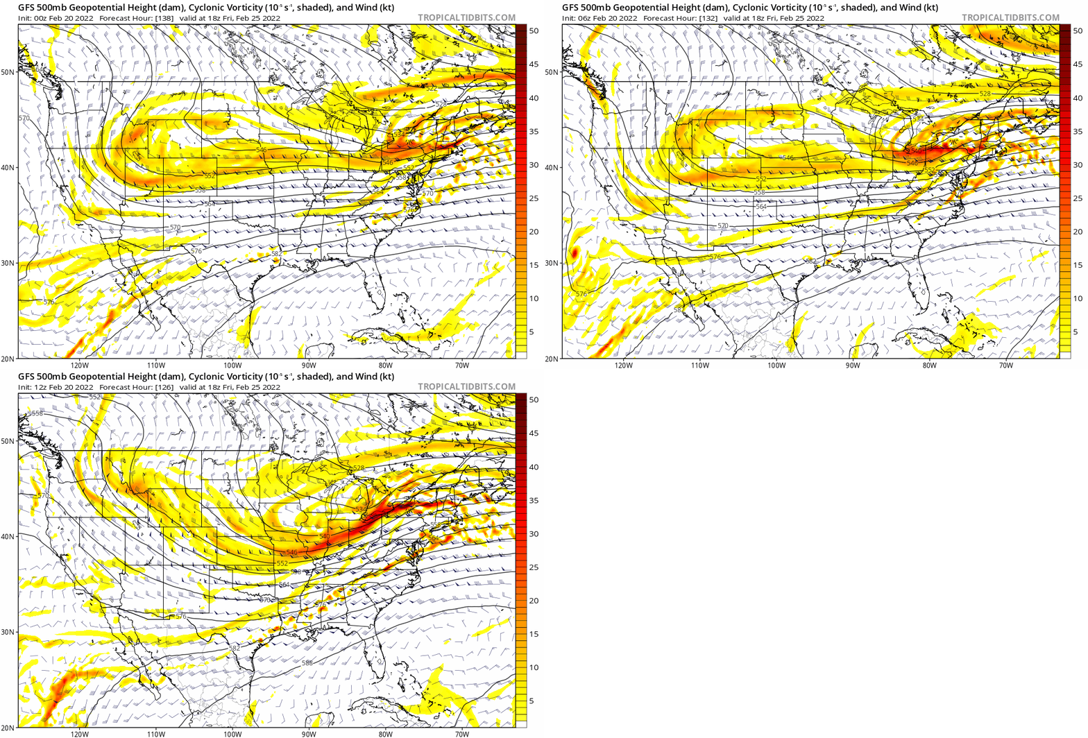
heehaw453 wrote:The GFS is continuing to correct folks. The SE ridge pushes back more each run which means higher heights and a stronger L that brings in warm air at the mid-levels. It must commended this time as the correction process is starting D5 instead of D3. Give it another 10 years of R&D work and it may get on par with other guidance. I still believe March can offer a real opportunity for the interior and possibly I95, but truth be told the luck just ain't there this year.
This maybe too pessimistic from Euro, but I think the idea is correct. Past I-84 for anything moderate and minor accumulations south of there. Just to show the differences and this is exactly the disparity at D5 that occurred on Feb 4. Euro never bought into the sig snow.
00Z Euro
06Z GFS
What luck ? I'm at 22 inches for the winter which is near normal here in NYC area.
Snow88- Senior Enthusiast

- Posts : 2193
Join date : 2013-01-09
 Re: Long Range Thread 24.0
Snow88 wrote:heehaw453 wrote:The GFS is continuing to correct folks. The SE ridge pushes back more each run which means higher heights and a stronger L that brings in warm air at the mid-levels. It must commended this time as the correction process is starting D5 instead of D3. Give it another 10 years of R&D work and it may get on par with other guidance. I still believe March can offer a real opportunity for the interior and possibly I95, but truth be told the luck just ain't there this year.
This maybe too pessimistic from Euro, but I think the idea is correct. Past I-84 for anything moderate and minor accumulations south of there. Just to show the differences and this is exactly the disparity at D5 that occurred on Feb 4. Euro never bought into the sig snow.
00Z Euro
06Z GFS
What luck ? I'm at 22 inches for the winter which is near normal here in NYC area.
If we had help from the Atlantic domain my guess is you'd be double that especially with the good PAC we've had. This is not a terrible winter by any stretch IMO, however, with the PAC as good as it's been PHL-NYC and NW burbs haven't done well with w.r.t. snowfall. It is what it is.
heehaw453- Advanced Forecaster

- Posts : 3906
Join date : 2014-01-20
 Re: Long Range Thread 24.0
heehaw, you've been navigating that r/s snow line all year pretty perfectly. Awesome job my man and thanks so much for the non-stop wonderful input!!!
As it stands now, last weeks storm looks to have officially broken the S and E trend, just like you said it would. No question that DocStox sold off his shares of Jersey Shore (JS) snow a few days prior! Still have a ways to go for RB's late winter forecast to shake things up for the better (both wrt individual storm chances and perhaps a return to a better trend for the coast). But for sure, our run is done on the Jersey coast, LI stays in the game pretty much to the end, and it's time for LHV and NWNJ to start reaping some rewards here...
As it stands now, last weeks storm looks to have officially broken the S and E trend, just like you said it would. No question that DocStox sold off his shares of Jersey Shore (JS) snow a few days prior! Still have a ways to go for RB's late winter forecast to shake things up for the better (both wrt individual storm chances and perhaps a return to a better trend for the coast). But for sure, our run is done on the Jersey coast, LI stays in the game pretty much to the end, and it's time for LHV and NWNJ to start reaping some rewards here...
SENJsnowman- Senior Enthusiast

- Posts : 1186
Reputation : 61
Join date : 2017-01-06
Age : 51
Location : Bayville, NJ
heehaw453 likes this post
 Re: Long Range Thread 24.0
SENJsnowman wrote:heehaw, you've been navigating that r/s snow line all year pretty perfectly. Awesome job my man and thanks so much for the non-stop wonderful input!!!
As it stands now, last weeks storm looks to have officially broken the S and E trend, just like you said it would. No question that DocStox sold off his shares of Jersey Shore (JS) snow a few days prior! Still have a ways to go for RB's late winter forecast to shake things up for the better (both wrt individual storm chances and perhaps a return to a better trend for the coast). But for sure, our run is done on the Jersey coast, LI stays in the game pretty much to the end, and it's time for LHV and NWNJ to start reaping some rewards here...
Thanks senj. If this relaxes towards neutral and we can keep the EPO/PNA good, then I'm on board for a nice March snow potential in the interior and potentially I95. If not, then my optimism is much less. My hope has been it at least gets to neutral beginning of March. But what's been occurring this winter time and time again is we cannot get alignment with the PAC/NAM state.

heehaw453- Advanced Forecaster

- Posts : 3906
Reputation : 86
Join date : 2014-01-20
Location : Bedminster Township, PA Elevation 600' ASL
SENJsnowman likes this post
 Re: Long Range Thread 24.0
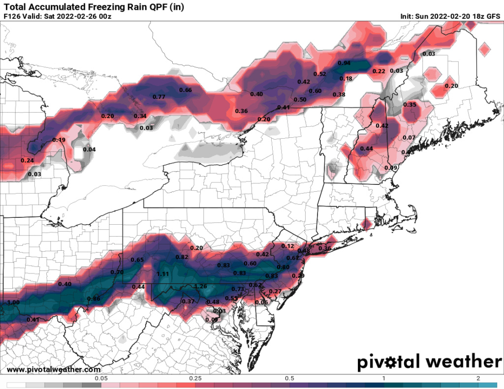
The ice potential on this Friday system is legit IMO for NW I95. Mid-levels will warm and cave like a house of cards, but not the low levels with a H like this in this position. This is a strong CAD signature at the low levels and all guidance has it to some form or another. My guess is freezing rain will extend much further south than beginning of February system.


heehaw453- Advanced Forecaster

- Posts : 3906
Reputation : 86
Join date : 2014-01-20
Location : Bedminster Township, PA Elevation 600' ASL
 Re: Long Range Thread 24.0
Does this get into southern westchester NY then? Will there be wind to contend with? One thing I do not want if Wind on top of frz, I work from home friday's and need my power and internet, as much as any weather interests me it would not be a good thing.heehaw453 wrote:The ice potential on this Friday system is legit IMO for NW I95. Mid-levels will warm and cave like a house of cards, but not the low levels with a H like this in this position. This is a strong CAD signature at the low levels and all guidance has it to some form or another. My guess is freezing rain will extend much further south than beginning of February system.

jmanley32- Senior Enthusiast

- Posts : 20516
Reputation : 108
Join date : 2013-12-12
Age : 42
Location : Yonkers, NY
 Re: Long Range Thread 24.0
Maybe this whole system will settle a bit further south than the 8nitial push north? Maybe? 3 to 6 in event changing to sleet ? Remember the winter in the md 90’s, 93 to 94 or 94 to 95 . Snow to sleet and then compaction. I see this s5orm as one of those that winter. I don’t think the system will expand northe like the current model blip.

WeatherBob- Meteorologist

- Posts : 683
Reputation : 83
Join date : 2013-12-13
Location : Caldwell, NJ - NW Essex County - Altitude 500 FT
 Re: Long Range Thread 24.0
Cold air will dominate this system!, My gut feeling

WeatherBob- Meteorologist

- Posts : 683
Reputation : 83
Join date : 2013-12-13
Location : Caldwell, NJ - NW Essex County - Altitude 500 FT
 Re: Long Range Thread 24.0
I consider this a “side swipe” storm. That’s my name for it and they can be very tricky. Zonal type flows with embedded troughs can over estimate the ridge to its east. Look at the high pressure to the Northwest , North and North east. Do not underestimated the cold air penetration to the south and east of this

WeatherBob- Meteorologist

- Posts : 683
Reputation : 83
Join date : 2013-12-13
Location : Caldwell, NJ - NW Essex County - Altitude 500 FT
SENJsnowman- Senior Enthusiast

- Posts : 1186
Reputation : 61
Join date : 2017-01-06
Age : 51
Location : Bayville, NJ
 Re: Long Range Thread 24.0
Doc, you remember that winter? I can’t remember the exact year back then. I am making the bold prediction right now that NNJ will see 3 to 6 in turning to sleet. If this forecast changes , it will be for more total accumulation. Depends on the initial rush of precip and the atmospheric profiles

WeatherBob- Meteorologist

- Posts : 683
Reputation : 83
Join date : 2013-12-13
Location : Caldwell, NJ - NW Essex County - Altitude 500 FT
 Re: Long Range Thread 24.0
It depends where the dig is, farther south and more intense , more rigging to the east but I still feel that the cold air to the northwest, north and northeast will hold. It’s tough to push that emense amount of cold air back to the north this time of year. Total snow cover over Canada, large pool of surface cold air. I love these events. Who wins out? My bet is in the north, not the warm ridge. I am excited to see the final outcome.

WeatherBob- Meteorologist

- Posts : 683
Reputation : 83
Join date : 2013-12-13
Location : Caldwell, NJ - NW Essex County - Altitude 500 FT
SENJsnowman likes this post
 Re: Long Range Thread 24.0
I love Meteorology and it’s so “geeky nerdy “ to people and I love it!

WeatherBob- Meteorologist

- Posts : 683
Reputation : 83
Join date : 2013-12-13
Location : Caldwell, NJ - NW Essex County - Altitude 500 FT
sroc4, amugs and weatherwatchermom like this post
 Re: Long Range Thread 24.0
This L is a track of ice south of I-84 IMO. GFS is now getting much more aligned with other guidance that has been advertising this track for days. The SE ridge gets more stout each run on the GFS. Unless models back off that SE ridge in the next few days which i highly doubt absent any Atlantic support other than TPV which IMO is too far north to beat that ridge down enough.
I could see a decent zr ice storm from NJ I-195- I78 and sleet from I-80 to around I-84 with more snow as you get past I-84. Not saying there won't be snow on the front end especially N of rt 80, but do think on the lighter side. Too early for specifics obviously, but feel ice is more on the table than snow with this one until you get into the MHV.

I could see a decent zr ice storm from NJ I-195- I78 and sleet from I-80 to around I-84 with more snow as you get past I-84. Not saying there won't be snow on the front end especially N of rt 80, but do think on the lighter side. Too early for specifics obviously, but feel ice is more on the table than snow with this one until you get into the MHV.

heehaw453- Advanced Forecaster

- Posts : 3906
Reputation : 86
Join date : 2014-01-20
Location : Bedminster Township, PA Elevation 600' ASL
 Re: Long Range Thread 24.0
WeatherBob wrote:Cold air will dominate this system!, My gut feeling
I agree with you Bob at the lower levels just not at the 850s.
heehaw453- Advanced Forecaster

- Posts : 3906
Reputation : 86
Join date : 2014-01-20
Location : Bedminster Township, PA Elevation 600' ASL
 Re: Long Range Thread 24.0
Yes, but think 3 to 6 is in the offering for NNJ , if there is a rush of precip at the early part of the storm , can see a solid 4 to 6 then sleet. Still not everything set!, minor fluctuations in the pivot point of the trough out west thrusting eastward can cause differences of 50 Miles or som downstream. Still early , let’s see the finer details after this rainstorm pushes thru.

WeatherBob- Meteorologist

- Posts : 683
Reputation : 83
Join date : 2013-12-13
Location : Caldwell, NJ - NW Essex County - Altitude 500 FT
amugs and heehaw453 like this post
 Re: Long Range Thread 24.0
WeatherBob wrote:Doc, you remember that winter? I can’t remember the exact year back then. I am making the bold prediction right now that NNJ will see 3 to 6 in turning to sleet. If this forecast changes , it will be for more total accumulation. Depends on the initial rush of precip and the atmospheric profiles
Bob, the one I remember was the March 1993 "superstorm" that dumped a foot of snow then 4 inches of sleet on top of it in my neck of the woods in Mahwah NJ. You needed a backhoe to shovel that mess of concrete.

docstox12- Wx Statistician Guru

- Posts : 8504
Reputation : 222
Join date : 2013-01-07
Age : 73
Location : Monroe NY
 Re: Long Range Thread 24.0
I borrow this from Donald Sutherland on American Weather. He speaks to the occurrences >= 4" of snow in NYC for period of Feb 20-29 over the last 70 years or so. He's not even speaking to how hostile the AO is right now which is almost +3 sigma. The base cold in CA coupled with the -EPO is the only thing stopping latter part of February from being much AN temps straight through. In December it was the -NAM state which prevented 60s around Christmas time as the SE ridge was beaten down even though PNA was -5 sigma.
Now since we don't have any PNA support coupled with a hostile NAM this week we get cutters. It's unfortunate, but we need other support for things to work out most of the time.
"Milder weather will return starting tomorrow, but some cold could return in time for a late week storm. As a result, interior sections of the Northeast could be in line for at least some accumulating snow. Despite some GFS runs showing 4" or more snow for New York City, the forecast pattern generally argues against such an outcome. During the February 20-29, 1950-2021 period, 4/13 (31%) of 4" or greater snowstorms saw a positive AO. The evolution of synoptic details will determine the outcome and, at present, most of the guidance argues against a moderate snowfall in and around New York City."
"The preliminary Arctic Oscillation (AO) was +2.988."
heehaw453- Advanced Forecaster

- Posts : 3906
Reputation : 86
Join date : 2014-01-20
Location : Bedminster Township, PA Elevation 600' ASL
 Re: Long Range Thread 24.0
Heehaw, all I can say right now to Mr Sutherland is “bring it on baby.” Those odds are like betting 1 to 12 or 13 to 24 or 25 to 36 on roulette 31%. SCIENCE!

WeatherBob- Meteorologist

- Posts : 683
Reputation : 83
Join date : 2013-12-13
Location : Caldwell, NJ - NW Essex County - Altitude 500 FT
MattyICE likes this post
 Re: Long Range Thread 24.0
Game on! 


WeatherBob- Meteorologist

- Posts : 683
Reputation : 83
Join date : 2013-12-13
Location : Caldwell, NJ - NW Essex County - Altitude 500 FT
 Re: Long Range Thread 24.0
Climo and cold air wins out. I'm in Bob's camp and 93-94 Roberto I remember very well. Many SWFE of 3-6, 4-8" storms with ice on top here above I80. Good call.
_________________
Mugs
AKA:King: Snow Weenie
Self Proclaimed
WINTER 2014-15 : 55.12" +.02 for 6 coatings (avg. 35")
WINTER 2015-16 Total - 29.8" (Avg 35")
WINTER 2016-17 : 39.5" so far

amugs- Advanced Forecaster - Mod

- Posts : 15093
Reputation : 213
Join date : 2013-01-07
Age : 54
Location : Hillsdale,NJ
MattyICE likes this post
 Re: Long Range Thread 24.0
Yikes, heehaww I hope your wrong, I find hard believe its go be that much frz that far south, i thinks it will end up being further north, cannot seem to find a sleet map, being snow maps on TT say 13 inches leads me to believe it'll be a inch or two of sleet yuck. Like last time though I am sure these numbers are greatly exaggerated.


jmanley32- Senior Enthusiast

- Posts : 20516
Reputation : 108
Join date : 2013-12-12
Age : 42
Location : Yonkers, NY
 Re: Long Range Thread 24.0
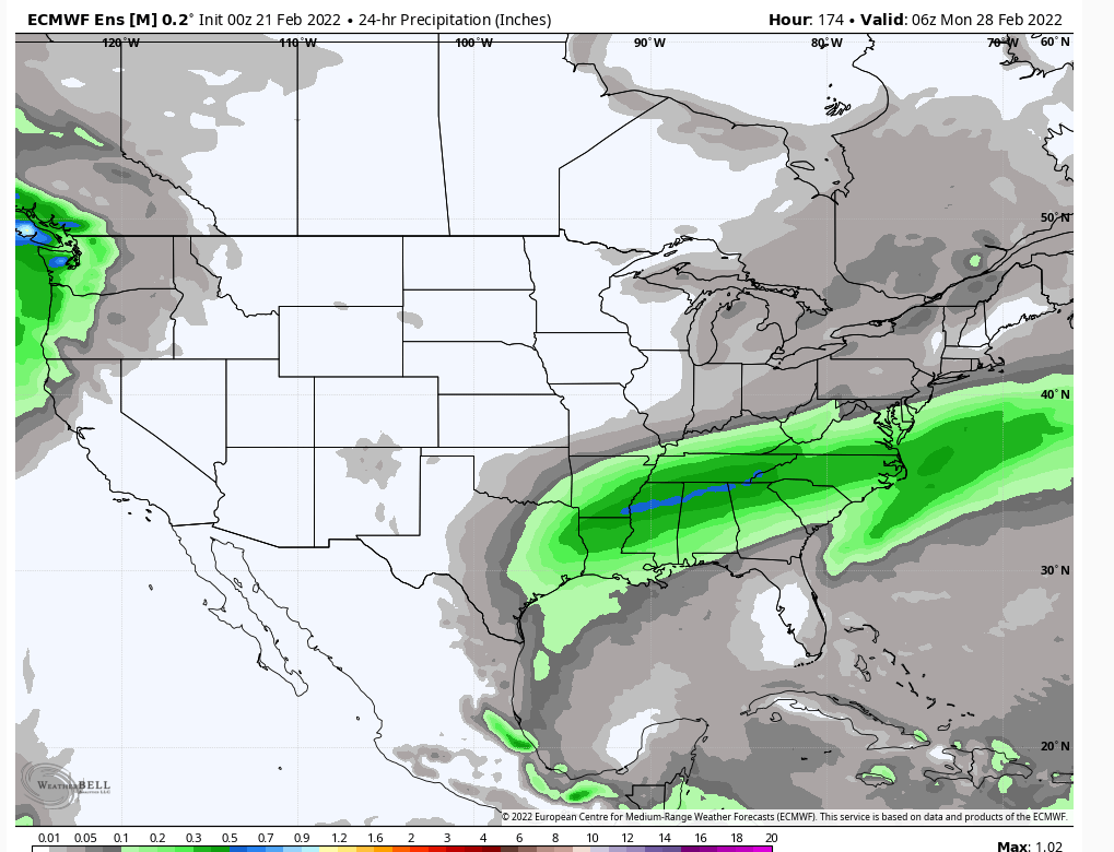
If the Euro is onto something 2/27 time frame is much much more interesting to me for a snow threat. The digging trough and PNA ridge coupled with ample already well established cold air is interesting. It won't cut with that look, but how far north it gets would be a question due to the northern trough. That one by itself could bring folks to normal February snowfalls IMO. Still a BIG IF of course at this range.


heehaw453- Advanced Forecaster

- Posts : 3906
Reputation : 86
Join date : 2014-01-20
Location : Bedminster Township, PA Elevation 600' ASL
 Re: Long Range Thread 24.0
For 2/27 threat. Models aren't biting on anything yet, but that ridge looks pretty good to me as well as good base cold established. It's showing a bit of energy being held back in the 4 corners and it just maybe that the TPV interferes with trough interaction and kind of squashes it. But I can say this I'd rather hope for something pulling north than hoping it slides south with this pattern. It's much easier for the former. Low threat chance for now...


heehaw453- Advanced Forecaster

- Posts : 3906
Reputation : 86
Join date : 2014-01-20
Location : Bedminster Township, PA Elevation 600' ASL
 Re: Long Range Thread 24.0
So im a bit confused the system that may be Sig ice is 26th and then something next day? I'm planning travel to CT thursday and coming back Sat. I can change my plans at latest Thursday evening. What do you guys think?

jmanley32- Senior Enthusiast

- Posts : 20516
Reputation : 108
Join date : 2013-12-12
Age : 42
Location : Yonkers, NY
 Re: Long Range Thread 24.0
jmanley32 wrote:So im a bit confused the system that may be Sig ice is 26th and then something next day? I'm planning travel to CT thursday and coming back Sat. I can change my plans at latest Thursday evening. What do you guys think?
Lol. I think you should Wait until a Thursday to change your plans.
_________________
"In weather and in life, there's no winning and losing; there's only winning and learning."
WINTER 2012/2013 TOTALS 43.65"WINTER 2017/2018 TOTALS 62.85" WINTER 2022/2023 TOTALS 4.9"
WINTER 2013/2014 TOTALS 64.85"WINTER 2018/2019 TOTALS 14.25" WINTER 2023/2024 TOTALS 13.1"
WINTER 2014/2015 TOTALS 71.20"WINTER 2019/2020 TOTALS 6.35"
WINTER 2015/2016 TOTALS 35.00"WINTER 2020/2021 TOTALS 37.75"
WINTER 2016/2017 TOTALS 42.25"WINTER 2021/2022 TOTALS 31.65"

sroc4- Admin

- Posts : 8331
Reputation : 301
Join date : 2013-01-07
Location : Wading River, LI
 Re: Long Range Thread 24.0
There's nothing to jinx with Friday IMO as expectations are pretty low for most of the forum. I've started a thread to help filter the conversation better.
>>>Feb 25 Event
>>>Feb 25 Event
heehaw453- Advanced Forecaster

- Posts : 3906
Reputation : 86
Join date : 2014-01-20
Location : Bedminster Township, PA Elevation 600' ASL
Page 16 of 21 •  1 ... 9 ... 15, 16, 17 ... 21
Page 16 of 21
Permissions in this forum:
You cannot reply to topics in this forum|
|
|

 Home
Home

