Tropics
+23
GreyBeard
brownie
docstox12
sabamfa
frank 638
Cyanide02Z06
Frank_Wx
jtswife
Joe Snow
aiannone
phil155
billg315
Zhukov1945
tomsriversnowstorm
Radz
Dunnzoo
sroc4
weatherwatchermom
rb924119
dkodgis
jmanley32
Quietace
amugs
27 posters
Page 9 of 19
Page 9 of 19 •  1 ... 6 ... 8, 9, 10 ... 14 ... 19
 Re: Tropics
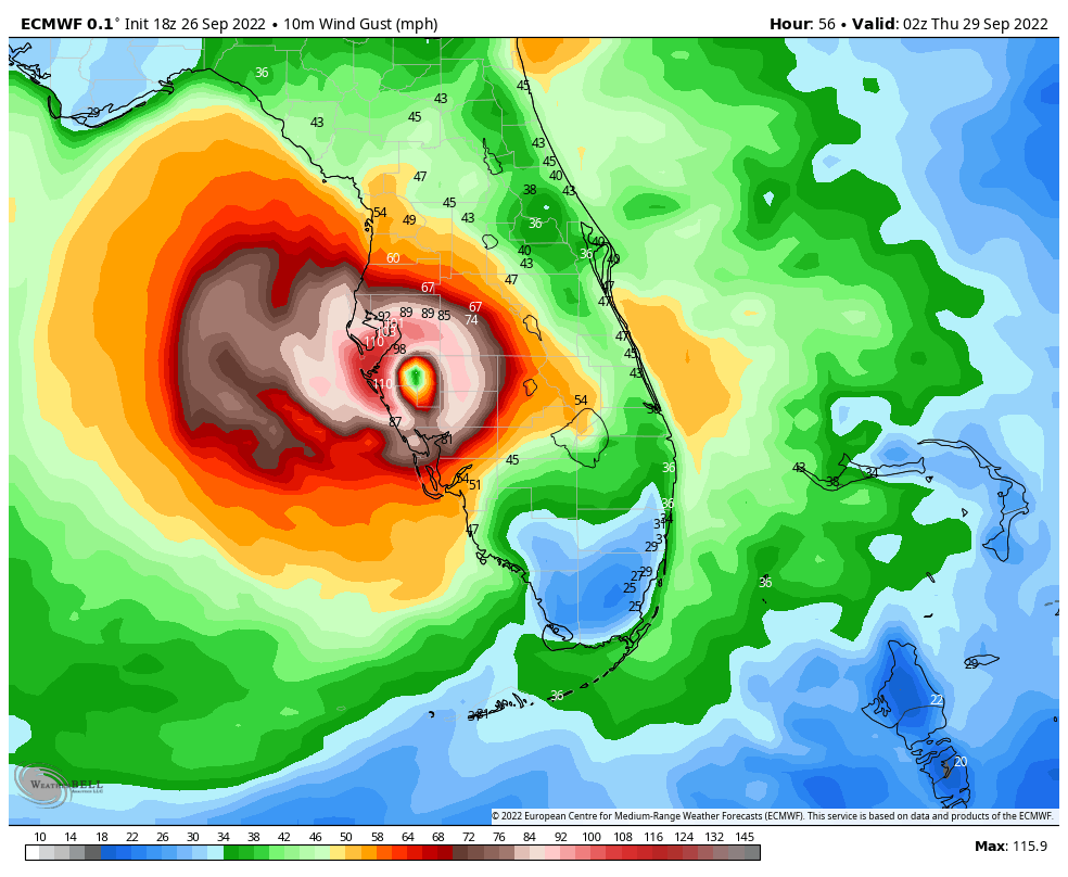
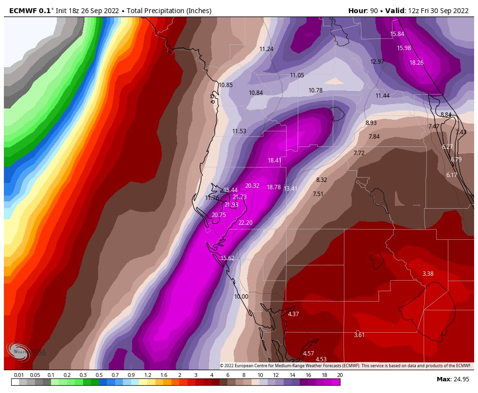
Fwiw 18z euro is significantly east. Like 50-60 miles. Landfalls smack between Tampa and Fort Meyers. Wipers, maybe but the track has been almost due north for the past 6-8hrs.
sroc4- Admin

- Posts : 8331
Join date : 2013-01-07
 Re: Tropics
jmanley32 wrote:MOG....sattelite is impressive, outer cloud bands are already hitting FL. You can see all the heavy convection wrapping in, this will be a cat 3 by or before morning if you ask me. maybe 4. No one is talking about poor cuba. they are going to get a direct hit too. Also noted that the windfield expanded greatly.rb924119 wrote:Down to 965mb on the second pass….
Friend in Boca said outer bands of heavy tropical rains all day.
_________________
Mugs
AKA:King: Snow Weenie
Self Proclaimed
WINTER 2014-15 : 55.12" +.02 for 6 coatings (avg. 35")
WINTER 2015-16 Total - 29.8" (Avg 35")
WINTER 2016-17 : 39.5" so far

amugs- Advanced Forecaster - Mod

- Posts : 15093
Reputation : 213
Join date : 2013-01-07
Age : 54
Location : Hillsdale,NJ
 Re: Tropics
It is important to monitor multi-run trends as a whole, but there was a non-negligible shift to the east with the mean and individual members of the 18z EPS for #Ian. This can be visualized easily when comparing 12z/18z runs valid 00z Thursday. #flwx pic.twitter.com/2TECfacuW6
— John Homenuk (@jhomenuk) September 27, 2022
_________________
Mugs
AKA:King: Snow Weenie
Self Proclaimed
WINTER 2014-15 : 55.12" +.02 for 6 coatings (avg. 35")
WINTER 2015-16 Total - 29.8" (Avg 35")
WINTER 2016-17 : 39.5" so far

amugs- Advanced Forecaster - Mod

- Posts : 15093
Reputation : 213
Join date : 2013-01-07
Age : 54
Location : Hillsdale,NJ

aiannone- Senior Enthusiast - Mod

- Posts : 4813
Reputation : 92
Join date : 2013-01-07
Location : Saint James, LI (Northwest Suffolk Co.)
 Re: Tropics
_________________
Mugs
AKA:King: Snow Weenie
Self Proclaimed
WINTER 2014-15 : 55.12" +.02 for 6 coatings (avg. 35")
WINTER 2015-16 Total - 29.8" (Avg 35")
WINTER 2016-17 : 39.5" so far

amugs- Advanced Forecaster - Mod

- Posts : 15093
Reputation : 213
Join date : 2013-01-07
Age : 54
Location : Hillsdale,NJ
 Re: Tropics
_________________
Mugs
AKA:King: Snow Weenie
Self Proclaimed
WINTER 2014-15 : 55.12" +.02 for 6 coatings (avg. 35")
WINTER 2015-16 Total - 29.8" (Avg 35")
WINTER 2016-17 : 39.5" so far

amugs- Advanced Forecaster - Mod

- Posts : 15093
Reputation : 213
Join date : 2013-01-07
Age : 54
Location : Hillsdale,NJ

aiannone- Senior Enthusiast - Mod

- Posts : 4813
Reputation : 92
Join date : 2013-01-07
Location : Saint James, LI (Northwest Suffolk Co.)
 Re: Tropics
...BREAKING...
— Mike Masco (@MikeMasco) September 27, 2022
Video of I-4 COMING OUT OF #TAMPA JAMMED WITH CARS HEADING EAST via FLDOT 10PM AT NIGHT! pic.twitter.com/wd6L0lc6zZ
_________________
Mugs
AKA:King: Snow Weenie
Self Proclaimed
WINTER 2014-15 : 55.12" +.02 for 6 coatings (avg. 35")
WINTER 2015-16 Total - 29.8" (Avg 35")
WINTER 2016-17 : 39.5" so far

amugs- Advanced Forecaster - Mod

- Posts : 15093
Reputation : 213
Join date : 2013-01-07
Age : 54
Location : Hillsdale,NJ
 Re: Tropics
_________________
Mugs
AKA:King: Snow Weenie
Self Proclaimed
WINTER 2014-15 : 55.12" +.02 for 6 coatings (avg. 35")
WINTER 2015-16 Total - 29.8" (Avg 35")
WINTER 2016-17 : 39.5" so far

amugs- Advanced Forecaster - Mod

- Posts : 15093
Reputation : 213
Join date : 2013-01-07
Age : 54
Location : Hillsdale,NJ
 Re: Tropics
_________________
Mugs
AKA:King: Snow Weenie
Self Proclaimed
WINTER 2014-15 : 55.12" +.02 for 6 coatings (avg. 35")
WINTER 2015-16 Total - 29.8" (Avg 35")
WINTER 2016-17 : 39.5" so far

amugs- Advanced Forecaster - Mod

- Posts : 15093
Reputation : 213
Join date : 2013-01-07
Age : 54
Location : Hillsdale,NJ
 Re: Tropics
Looks like down to 963mb now basis latest recon.
rb924119- Meteorologist

- Posts : 6889
Reputation : 194
Join date : 2013-02-06
Age : 32
Location : Greentown, Pa
 Re: Tropics
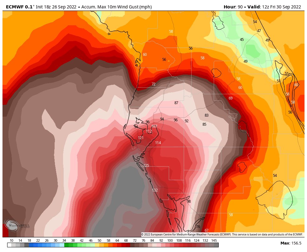
Even thats too much wind for me jeeze, looks like we may have a possible track up coast if it croses FL into water again, that would be nuts, if the models had it all along 5 days ago. And a few of those I recall hand a landfall up here, it ain't over till it's over. It has been my experience that the stronger a storm and the more moving parts involved the more often are there surprises good or bad. This could be Tampa's Andrew no? 156mph gusts good lord.

jmanley32- Senior Enthusiast

- Posts : 20513
Reputation : 108
Join date : 2013-12-12
Age : 42
Location : Yonkers, NY
 Re: Tropics
Woah 18z Euro, crosses FL....

jmanley32- Senior Enthusiast

- Posts : 20513
Reputation : 108
Join date : 2013-12-12
Age : 42
Location : Yonkers, NY
 Re: Tropics
Ya gotta love the NAM just for S & G 898mb....no thats not a typo. I get its because of the hi-res but come on. It has corrected east too though still well offshore. Of course not the one to go by, at least not at this point.

jmanley32- Senior Enthusiast

- Posts : 20513
Reputation : 108
Join date : 2013-12-12
Age : 42
Location : Yonkers, NY
 Re: Tropics
jmanley32 wrote:Ya gotta love the NAM just for S & G 898mb....no thats not a typo. I get its because of the hi-res but come on. It has corrected east too though still well offshore. Of course not the one to go by, at least not at this point.
LOCK. IT. IN.!!! lmaooooo
rb924119- Meteorologist

- Posts : 6889
Reputation : 194
Join date : 2013-02-06
Age : 32
Location : Greentown, Pa
 Re: Tropics
Per latest recon, looks to be down to ~960 mb and nearly 100kt winds.
rb924119- Meteorologist

- Posts : 6889
Reputation : 194
Join date : 2013-02-06
Age : 32
Location : Greentown, Pa
 Re: Tropics
STILL looks like there are two different circulations based on the wind barns, but there’s definitely only one pressure center. Very odd.
I’m a dumb@as lol it’s not two different circulations - it’s them doing a lap around the eye in successive passes LMAOOOOO wow, I feel dumb

I’m a dumb@as lol it’s not two different circulations - it’s them doing a lap around the eye in successive passes LMAOOOOO wow, I feel dumb
Last edited by rb924119 on Tue Sep 27, 2022 1:29 am; edited 1 time in total
rb924119- Meteorologist

- Posts : 6889
Reputation : 194
Join date : 2013-02-06
Age : 32
Location : Greentown, Pa
 Re: Tropics
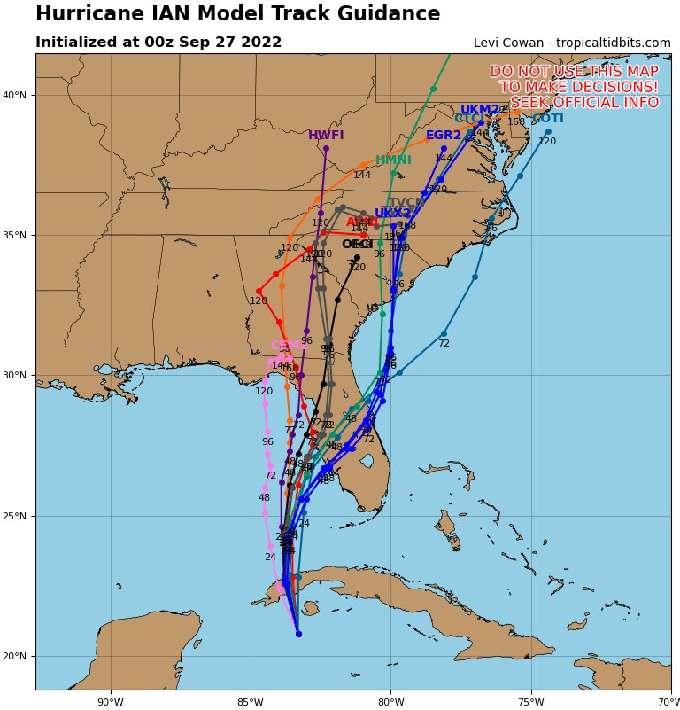
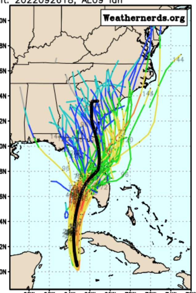
I don’t think this track is set yet, AT ALL. If you look at the spread in the ensemble data coming in now, it’s actually gotten LARGER as lead time is decreasing. This is highly indicative of complicating factors, so we are all going to have to watch this like like a hawk. The 00z GFS Ensemble is literally useless right now lol unreal.
rb924119- Meteorologist

- Posts : 6889
Reputation : 194
Join date : 2013-02-06
Age : 32
Location : Greentown, Pa
 Re: Tropics
The first test of my idea is coming up over the next several hours. Does it barrel its way over the wider part of the Cuban island? Or, do we see the low-level pressure perturbations allow it to “pinball” around the the thick part, and just cross over the tiniest part of the western island? Conceptually, it should be the latter, as the wind piles up against the island on the northeast quadrant due to friction, (thereby increasing the surface pressure relative to the environment), but remain steady-state further west (relatively lower pressure compared to the northeast quadrant). Think of your resulting pressure gradient force and how it would tend to be directed (high to low is where the air must go). I think it pinballs around, and keeps the heart of the main circulation nearly completely free of any land interaction. Time will tell……
rb924119- Meteorologist

- Posts : 6889
Reputation : 194
Join date : 2013-02-06
Age : 32
Location : Greentown, Pa
 Re: Tropics
https://twitter.com/raleighwx/status/1574709418935083010?s=46&t=VVnCOvoQ4uQYRY73vBlVSA
_________________
_______________________________________________________________________________________________________
CLICK HERE to view NJ Strong Snowstorm Classifications
 Re: Tropics
rb924119 wrote:The first test of my idea is coming up over the next several hours. Does it barrel its way over the wider part of the Cuban island? Or, do we see the low-level pressure perturbations allow it to “pinball” around the the thick part, and just cross over the tiniest part of the western island? Conceptually, it should be the latter, as the wind piles up against the island on the northeast quadrant due to friction, (thereby increasing the surface pressure relative to the environment), but remain steady-state further west (relatively lower pressure compared to the northeast quadrant). Think of your resulting pressure gradient force and how it would tend to be directed (high to low is where the air must go). I think it pinballs around, and keeps the heart of the main circulation nearly completely free of any land interaction. Time will tell……
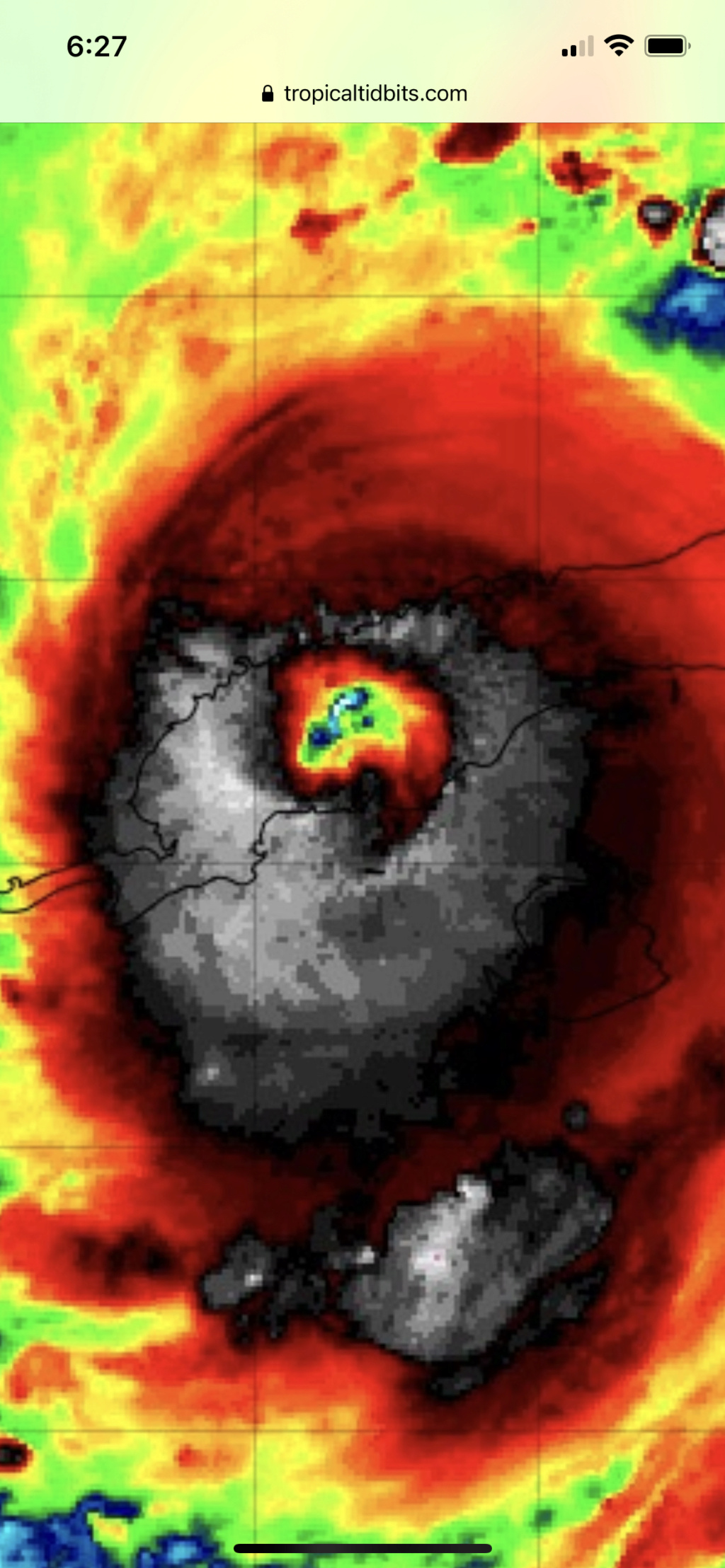
It’s only got another hour or two before it exits the other side but this definitely went right over the meat of Cuba. On the loop you can see it already has a bit of a NNE component to its movement. The writing was on the wall with most of the latter part of yesterday having a much more Northerly to NNWesterly track occurred gaining latitude and rising the eastern side of the forecast cone.
https://www.tropicaltidbits.com/sat/satlooper.php?region=09L&product=ir
While the GFS ensembles may be lost the European ensembles seemed locked in with landfall between Tampa and Ft Meyers.
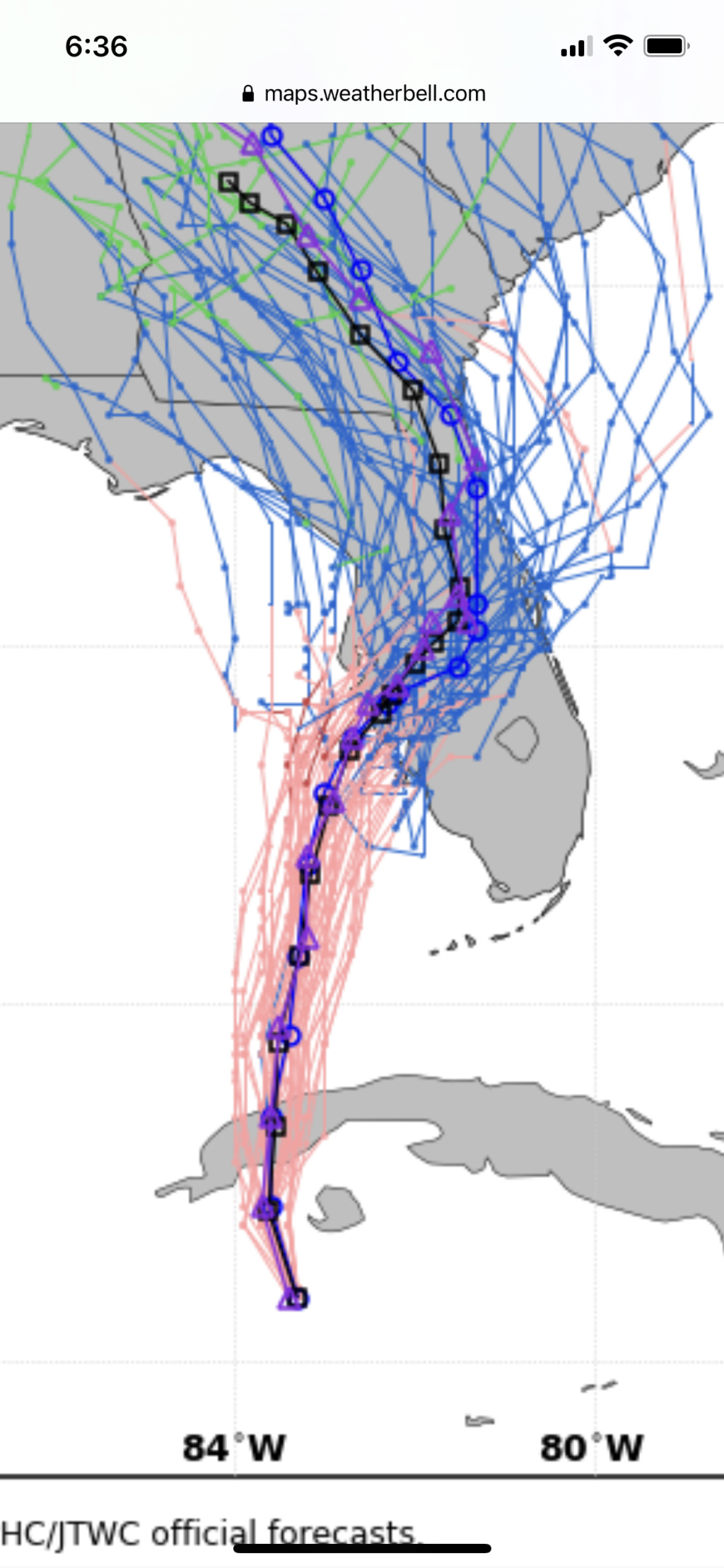
While there is certainly still a little wiggle room here as the HWRF still takes it much further up the coast into the big bend, it looks like the eastern track solns and a direct landfall is getting closer and closer to imminent.
_________________
"In weather and in life, there's no winning and losing; there's only winning and learning."
WINTER 2012/2013 TOTALS 43.65"WINTER 2017/2018 TOTALS 62.85" WINTER 2022/2023 TOTALS 4.9"
WINTER 2013/2014 TOTALS 64.85"WINTER 2018/2019 TOTALS 14.25" WINTER 2023/2024 TOTALS 13.1"
WINTER 2014/2015 TOTALS 71.20"WINTER 2019/2020 TOTALS 6.35"
WINTER 2015/2016 TOTALS 35.00"WINTER 2020/2021 TOTALS 37.75"
WINTER 2016/2017 TOTALS 42.25"WINTER 2021/2022 TOTALS 31.65"

sroc4- Admin

- Posts : 8331
Reputation : 301
Join date : 2013-01-07
Location : Wading River, LI
 Re: Tropics
sroc4 wrote:rb924119 wrote:The first test of my idea is coming up over the next several hours. Does it barrel its way over the wider part of the Cuban island? Or, do we see the low-level pressure perturbations allow it to “pinball” around the the thick part, and just cross over the tiniest part of the western island? Conceptually, it should be the latter, as the wind piles up against the island on the northeast quadrant due to friction, (thereby increasing the surface pressure relative to the environment), but remain steady-state further west (relatively lower pressure compared to the northeast quadrant). Think of your resulting pressure gradient force and how it would tend to be directed (high to low is where the air must go). I think it pinballs around, and keeps the heart of the main circulation nearly completely free of any land interaction. Time will tell……
It’s only got another hour or two before it exits the other side but this definitely went right over the meat of Cuba. On the loop you can see it already has a bit of a NNE component to its movement. The writing was on the wall with most of the latter part of yesterday having a much more Northerly to NNWesterly track occurred gaining latitude and rising the eastern side of the forecast cone.
https://www.tropicaltidbits.com/sat/satlooper.php?region=09L&product=ir
While the GFS ensembles may be lost the European ensembles seemed locked in with landfall between Tampa and Ft Meyers.
While there is certainly still a little wiggle room here as the HWRF still takes it much further up the coast into the big bend, it looks like the eastern track solns and a direct landfall is getting closer and closer to imminent.
Sroc is that good that it went over Cuba.? Won’t that weaken it ? Is there any chance this can weaken? Sorry just don’t know and you guys do so picking your brains.
tomsriversnowstorm- Posts : 90
Reputation : 0
Join date : 2021-02-06
sroc4 likes this post
 Re: Tropics
tomsriversnowstorm wrote:sroc4 wrote:rb924119 wrote:The first test of my idea is coming up over the next several hours. Does it barrel its way over the wider part of the Cuban island? Or, do we see the low-level pressure perturbations allow it to “pinball” around the the thick part, and just cross over the tiniest part of the western island? Conceptually, it should be the latter, as the wind piles up against the island on the northeast quadrant due to friction, (thereby increasing the surface pressure relative to the environment), but remain steady-state further west (relatively lower pressure compared to the northeast quadrant). Think of your resulting pressure gradient force and how it would tend to be directed (high to low is where the air must go). I think it pinballs around, and keeps the heart of the main circulation nearly completely free of any land interaction. Time will tell……
It’s only got another hour or two before it exits the other side but this definitely went right over the meat of Cuba. On the loop you can see it already has a bit of a NNE component to its movement. The writing was on the wall with most of the latter part of yesterday having a much more Northerly to NNWesterly track occurred gaining latitude and rising the eastern side of the forecast cone.
https://www.tropicaltidbits.com/sat/satlooper.php?region=09L&product=ir
While the GFS ensembles may be lost the European ensembles seemed locked in with landfall between Tampa and Ft Meyers.
While there is certainly still a little wiggle room here as the HWRF still takes it much further up the coast into the big bend, it looks like the eastern track solns and a direct landfall is getting closer and closer to imminent.
Sroc is that good that it went over Cuba.? Won’t that weaken it ? Is there any chance this can weaken? Sorry just don’t know and you guys do so picking your brains.
As a general rule Tropical systems over land weaken it for sure. But in this case it isn’t likely to weaken it very much if at all. Reason being is that a) the western side of Cuba is very flat topographically which minimizes any friction and lessens the turbulence to the wind fields that might occur otherwise if the winds were to run into a more mountainous terrain, and b) it will only be over land for a very short time. The fuel that drives a tropical system is the warm waters . So while over land it’s fuel supply is cutoff; however, if you look above at the image I posted the diameter of eye wall structure is almost that of the width of land of which it’s crossing. So really there is a very short window where the eye wall in it’s entirety is over land. As soon as it emerges on the other side of Cuba it goes right back over very warm waters and will immediately get back at it; likely strengthening right off the bat.
There are elements that can still weaken the storm. Unfortunately the short lived track over western Cuba isn’t likely one of them and if it is it will be minor and temporary. The further Nand Wthe track the more likely Ian is to run into some shearing forces and dry air infiltration that would likely weaken him right before landfall. The further S and E the track the further away he stays from these elements and he landfalls before much of those interactions. Unfortunately the trend through this am has been the SE track so the system likely remains a major as it makes landfall.
Hope that helped.
Scott
_________________
"In weather and in life, there's no winning and losing; there's only winning and learning."
WINTER 2012/2013 TOTALS 43.65"WINTER 2017/2018 TOTALS 62.85" WINTER 2022/2023 TOTALS 4.9"
WINTER 2013/2014 TOTALS 64.85"WINTER 2018/2019 TOTALS 14.25" WINTER 2023/2024 TOTALS 13.1"
WINTER 2014/2015 TOTALS 71.20"WINTER 2019/2020 TOTALS 6.35"
WINTER 2015/2016 TOTALS 35.00"WINTER 2020/2021 TOTALS 37.75"
WINTER 2016/2017 TOTALS 42.25"WINTER 2021/2022 TOTALS 31.65"

sroc4- Admin

- Posts : 8331
Reputation : 301
Join date : 2013-01-07
Location : Wading River, LI
kalleg likes this post
 Re: Tropics
sroc4 wrote:tomsriversnowstorm wrote:sroc4 wrote:rb924119 wrote:The first test of my idea is coming up over the next several hours. Does it barrel its way over the wider part of the Cuban island? Or, do we see the low-level pressure perturbations allow it to “pinball” around the the thick part, and just cross over the tiniest part of the western island? Conceptually, it should be the latter, as the wind piles up against the island on the northeast quadrant due to friction, (thereby increasing the surface pressure relative to the environment), but remain steady-state further west (relatively lower pressure compared to the northeast quadrant). Think of your resulting pressure gradient force and how it would tend to be directed (high to low is where the air must go). I think it pinballs around, and keeps the heart of the main circulation nearly completely free of any land interaction. Time will tell……
It’s only got another hour or two before it exits the other side but this definitely went right over the meat of Cuba. On the loop you can see it already has a bit of a NNE component to its movement. The writing was on the wall with most of the latter part of yesterday having a much more Northerly to NNWesterly track occurred gaining latitude and rising the eastern side of the forecast cone.
https://www.tropicaltidbits.com/sat/satlooper.php?region=09L&product=ir
While the GFS ensembles may be lost the European ensembles seemed locked in with landfall between Tampa and Ft Meyers.
While there is certainly still a little wiggle room here as the HWRF still takes it much further up the coast into the big bend, it looks like the eastern track solns and a direct landfall is getting closer and closer to imminent.
Sroc is that good that it went over Cuba.? Won’t that weaken it ? Is there any chance this can weaken? Sorry just don’t know and you guys do so picking your brains.
As a general rule Tropical systems over land weaken it for sure. But in this case it isn’t likely to weaken it very much if at all. Reason being is that a) the western side of Cuba is very flat topographically which minimizes any friction and lessens the turbulence to the wind fields that might occur otherwise if the winds were to run into a more mountainous terrain, and b) it will only be over land for a very short time. The fuel that drives a tropical system is the warm waters . So while over land it’s fuel supply is cutoff; however, if you look above at the image I posted the diameter of eye wall structure is almost that of the width of land of which it’s crossing. So really there is a very short window where the eye wall in it’s entirety is over land. As soon as it emerges on the other side of Cuba it goes right back over very warm waters and will immediately get back at it; likely strengthening right off the bat.
There are elements that can still weaken the storm. Unfortunately the short lived track over western Cuba isn’t likely one of them and if it is it will be minor and temporary. The further Nand Wthe track the more likely Ian is to run into some shearing forces and dry air infiltration that would likely weaken him right before landfall. The further S and E the track the further away he stays from these elements and he landfalls before much of those interactions. Unfortunately the trend through this am has been the SE track so the system likely remains a major as it makes landfall.
Hope that helped.
Scott
Scott,
That helped a lot. While I may not like the news I learned a lot from it. Thank you so much. Hopefully the people in Florida are prepared.
tomsriversnowstorm- Posts : 90
Reputation : 0
Join date : 2021-02-06
sroc4 likes this post
 Re: Tropics
Oh boy just texted my ex..he nd family moved to Florida this year...cape Coral! Is that not where the worst of this storm is going to be?

weatherwatchermom- Senior Enthusiast

- Posts : 3735
Reputation : 77
Join date : 2014-11-25
Age : 60
Location : Hazlet Township, NJ
 Re: Tropics
https://www.youtube.com/watch?v=ojidrZ8uFtA

dkodgis- Senior Enthusiast

- Posts : 2496
Reputation : 98
Join date : 2013-12-29
Page 9 of 19 •  1 ... 6 ... 8, 9, 10 ... 14 ... 19
Page 9 of 19
Permissions in this forum:
You cannot reply to topics in this forum|
|
|

 Home
Home