
 Search
Long Range Thread 25.0
Page 10 of 40 •  1 ... 6 ... 9, 10, 11 ... 25 ... 40
 ![]()
Re: Long Range Thread 25.0
![]() by amugs Fri Dec 09, 2022 8:52 pm
by amugs Fri Dec 09, 2022 8:52 pm
Irish wrote:amugs wrote:This is WOW JUST WOW!!
WHERE DID IT GO? Hiding with CP??
Could you imagine??
Ummmm... what happened?


It is such a deep Negative EPO it is off the charts, if it verifies it shatters records and drive absolutely

tremendous cold into the lower 48.
This map is mint for extreme cold and the entire country goes into the freezer with this look.
This by the Euro Control would be a heck of a storm.


amugs- Advanced Forecaster - Mod

- Posts : 15093
Join date : 2013-01-07
Irish likes this post
Re: Long Range Thread 25.0
![]() by jmanley32 Sat Dec 10, 2022 3:48 am
by jmanley32 Sat Dec 10, 2022 3:48 am
Hour 312 really? really? We all know better than to look at that. 20's in FL, I will bet that won't happen but of course i could be wrong lets check back in 9-11 days.amugs wrote:Irish wrote:amugs wrote:This is WOW JUST WOW!!
WHERE DID IT GO? Hiding with CP??
Could you imagine??
Ummmm... what happened?
It is such a deep Negative EPO it is off the charts, if it verifies it shatters records and drive absolutely
tremendous cold into the lower 48.
This map is mint for extreme cold and the entire country goes into the freezer with this look.
This by the Euro Control would be a heck of a storm.
jmanley32- Senior Enthusiast

- Posts : 20516
Join date : 2013-12-12
Re: Long Range Thread 25.0
![]() by SENJsnowman Sat Dec 10, 2022 7:18 am
by SENJsnowman Sat Dec 10, 2022 7:18 am
SENJsnowman- Senior Enthusiast
- Posts : 1186
Reputation : 61
Join date : 2017-01-06
Age : 51
Location : Bayville, NJ
Irish likes this post
Re: Long Range Thread 25.0
![]() by sroc4 Sat Dec 10, 2022 8:04 am
by sroc4 Sat Dec 10, 2022 8:04 am

This map is the Euro ensemble mean for the week headed into the Christmas weekend. Mugs posted similar map yesterday but I really think it bares repeating.

IF this look comes to fruition I would be absolutely shocked if 95% of this board didn't have a white Christmas. I mean truly shocked. This is about as text book of a look for a wide spread arctic outbreak and snow potential as I have seen in a really long time.
Now please let me reiterate this. I'm sure there are some of you reading this and rolling the eyes thinking ok here we go again. Another overhyped post that wont even come close to the hype. Your right. That is probably true. But even close to this look with the trough south of the Aleutians, the ridging into Alaska, the N Pole, and into the Greenland area will absolutely produce multiple snow opportunities into the NE. There is NO QUESTION about that.
Now this is nothing more than a cautiously optimistic broad brushed big picture overview of where the pattern appears to be headed, but there is a lot to be excited about. This is not coming from this one map from this one model either. There are multiple levels/layers of possible support for this outcome or some version of this outcome regarding the pattern. Which part of the NE will see what and when, we don't start to hone in on those details until inside the 5-7day mark, and then in your back yard and/or mine, not until inside 1-3days, so please dont look beyond the big picture for now regarding this time frame and remember it can and will likely change as we get in closer.
So again I will end with the proverbial grain of salt.

_________________
"In weather and in life, there's no winning and losing; there's only winning and learning."
WINTER 2012/2013 TOTALS 43.65"WINTER 2017/2018 TOTALS 62.85" WINTER 2022/2023 TOTALS 4.9"
WINTER 2013/2014 TOTALS 64.85"WINTER 2018/2019 TOTALS 14.25" WINTER 2023/2024 TOTALS 13.1"
WINTER 2014/2015 TOTALS 71.20"WINTER 2019/2020 TOTALS 6.35"
WINTER 2015/2016 TOTALS 35.00"WINTER 2020/2021 TOTALS 37.75"
WINTER 2016/2017 TOTALS 42.25"WINTER 2021/2022 TOTALS 31.65"

sroc4- Admin

- Posts : 8331
Reputation : 301
Join date : 2013-01-07
Location : Wading River, LI
Frank_Wx, weatherwatchermom and Irish like this post
Re: Long Range Thread 25.0
![]() by heehaw453 Sat Dec 10, 2022 8:07 am
by heehaw453 Sat Dec 10, 2022 8:07 am

heehaw453- Advanced Forecaster

- Posts : 3906
Reputation : 86
Join date : 2014-01-20
Location : Bedminster Township, PA Elevation 600' ASL
sroc4 likes this post
Re: Long Range Thread 25.0
![]() by sroc4 Sat Dec 10, 2022 8:21 am
by sroc4 Sat Dec 10, 2022 8:21 am


_________________
"In weather and in life, there's no winning and losing; there's only winning and learning."
WINTER 2012/2013 TOTALS 43.65"WINTER 2017/2018 TOTALS 62.85" WINTER 2022/2023 TOTALS 4.9"
WINTER 2013/2014 TOTALS 64.85"WINTER 2018/2019 TOTALS 14.25" WINTER 2023/2024 TOTALS 13.1"
WINTER 2014/2015 TOTALS 71.20"WINTER 2019/2020 TOTALS 6.35"
WINTER 2015/2016 TOTALS 35.00"WINTER 2020/2021 TOTALS 37.75"
WINTER 2016/2017 TOTALS 42.25"WINTER 2021/2022 TOTALS 31.65"
sroc4- Admin
- Posts : 8331
Reputation : 301
Join date : 2013-01-07
Location : Wading River, LI
heehaw453 likes this post
Re: Long Range Thread 25.0
![]() by heehaw453 Sat Dec 10, 2022 8:23 am
by heehaw453 Sat Dec 10, 2022 8:23 am
Edit: Something be brewin' folks. Pieces are there details unclear.

heehaw453- Advanced Forecaster
- Posts : 3906
Reputation : 86
Join date : 2014-01-20
Location : Bedminster Township, PA Elevation 600' ASL
sroc4 likes this post
Re: Long Range Thread 25.0
![]() by sroc4 Sat Dec 10, 2022 8:30 am
by sroc4 Sat Dec 10, 2022 8:30 am
heehaw453 wrote:06Z EPS WoW. Very strong signal by a mean for the late week threat. That depiction is not fantasy land time frame as you can see.
Totally Haw. We have the obv ridging tothe N that will force our system underneath. But the wave spacing between our system and the ULL 50/50 low to the NE, and the ULL off the west coast will need to be watched. If the one out west is to close on the heals of our system then we wont see a spike in the PNA domain and we will likely see a flatter W-E trajectory. If it hangs back expect a little +PNA ridge to show up with its axis ideally somewhere around Nevada and a bit more of a digging; combined with the clogged atlantic a negative tilt and deepining system with a better storm track.

Last edited by sroc4 on Sat Dec 10, 2022 8:32 am; edited 1 time in total
_________________
"In weather and in life, there's no winning and losing; there's only winning and learning."
WINTER 2012/2013 TOTALS 43.65"WINTER 2017/2018 TOTALS 62.85" WINTER 2022/2023 TOTALS 4.9"
WINTER 2013/2014 TOTALS 64.85"WINTER 2018/2019 TOTALS 14.25" WINTER 2023/2024 TOTALS 13.1"
WINTER 2014/2015 TOTALS 71.20"WINTER 2019/2020 TOTALS 6.35"
WINTER 2015/2016 TOTALS 35.00"WINTER 2020/2021 TOTALS 37.75"
WINTER 2016/2017 TOTALS 42.25"WINTER 2021/2022 TOTALS 31.65"
sroc4- Admin
- Posts : 8331
Reputation : 301
Join date : 2013-01-07
Location : Wading River, LI
Re: Long Range Thread 25.0
![]() by weatherwatchermom Sat Dec 10, 2022 8:32 am
by weatherwatchermom Sat Dec 10, 2022 8:32 am
sroc4 wrote:heehaw453 wrote:06Z EPS WoW. Very strong signal by a mean for the late week threat. That depiction is not fantasy land time frame as you can see.
Totally Haw. We have the obv ridging tothe N that will force our system underneath. But the wave spacing between our system and the ULL 50/50 low to the NE, and the ULL off the west coast will need to be watched. If the on out west is to close on the heals of our system then we wont see a spike in the PNA domain. If it hangs back expect a little +PNA ridge to show up with its axis ideally somewhere around Nevada.
Will up the odds supposed to travel to Boston next weekend for Xmas party..so Murphy's law..it will snow..

weatherwatchermom- Senior Enthusiast
- Posts : 3738
Reputation : 77
Join date : 2014-11-25
Age : 60
Location : Hazlet Township, NJ
sroc4 likes this post
Re: Long Range Thread 25.0
![]() by amugs Sat Dec 10, 2022 8:43 am
by amugs Sat Dec 10, 2022 8:43 am
Pattern recognition my man. As my pointed out and Scott so intelligently and graciously explained when u have positives and deep positives over the ENTIRE arctic region you force everything down under it cold and storms. I'm pointing out what we see happening, for sure storms are NOT cutting into a 1035 or 1040 or 1032 HP system they run into it and have to transfer to the weakness.....which is usually the braclonic zone and it's off the coast due to physics. Isn't majestic how nature works.
Buckle up because as I stated on here the last week with maps the storm track and once we have the bridge connected between the NAO and EPO regions.......WATCH OUT under neath the bridge!!
_________________
Mugs
AKA:King: Snow Weenie
Self Proclaimed
WINTER 2014-15 : 55.12" +.02 for 6 coatings (avg. 35")
WINTER 2015-16 Total - 29.8" (Avg 35")
WINTER 2016-17 : 39.5" so far

amugs- Advanced Forecaster - Mod
- Posts : 15093
Reputation : 213
Join date : 2013-01-07
Age : 54
Location : Hillsdale,NJ
weatherwatchermom likes this post
Re: Long Range Thread 25.0
![]() by amugs Sat Dec 10, 2022 8:45 am
by amugs Sat Dec 10, 2022 8:45 am

_________________
Mugs
AKA:King: Snow Weenie
Self Proclaimed
WINTER 2014-15 : 55.12" +.02 for 6 coatings (avg. 35")
WINTER 2015-16 Total - 29.8" (Avg 35")
WINTER 2016-17 : 39.5" so far
amugs- Advanced Forecaster - Mod
- Posts : 15093
Reputation : 213
Join date : 2013-01-07
Age : 54
Location : Hillsdale,NJ
weatherwatchermom and MattyICE like this post
Re: Long Range Thread 25.0
![]() by Frank_Wx Sat Dec 10, 2022 9:55 am
by Frank_Wx Sat Dec 10, 2022 9:55 am
_________________
_______________________________________________________________________________________________________
CLICK HERE to view NJ Strong Snowstorm Classifications

Frank_Wx- Godzilla Seeker
- Posts : 21305
Reputation : 328
Join date : 2013-01-05
Age : 31
Location : Jersey City, NJ -

weatherwatchermom likes this post
Re: Long Range Thread 25.0
![]() by billg315 Sat Dec 10, 2022 10:26 am
by billg315 Sat Dec 10, 2022 10:26 am
The specifics between all the models have plenty of time to work themselves out but has to be encouraging that all of them are recognizing potential for something big whether it be the Canadian Thur into Fri; the Euro Fri into Sat; or the GFS Sunday.

billg315- Advanced Forecaster - Mod
- Posts : 4466
Reputation : 185
Join date : 2015-01-24
Age : 50
Location : Flemington, NJ
Re: Long Range Thread 25.0
![]() by heehaw453 Sat Dec 10, 2022 11:49 am
by heehaw453 Sat Dec 10, 2022 11:49 am
heehaw453- Advanced Forecaster
- Posts : 3906
Reputation : 86
Join date : 2014-01-20
Location : Bedminster Township, PA Elevation 600' ASL
SoulSingMG likes this post
Re: Long Range Thread 25.0
![]() by heehaw453 Sat Dec 10, 2022 1:44 pm
by heehaw453 Sat Dec 10, 2022 1:44 pm

heehaw453- Advanced Forecaster
- Posts : 3906
Reputation : 86
Join date : 2014-01-20
Location : Bedminster Township, PA Elevation 600' ASL
MattyICE likes this post
Re: Long Range Thread 25.0
![]() by MattyICE Sat Dec 10, 2022 2:42 pm
by MattyICE Sat Dec 10, 2022 2:42 pm
heehaw453 wrote:I want the ridge more stout and coming through the Rockies as opposed to where Euro has it depicted at 12Z. I have no idea where the ridge will form and this just informational, but a storm is coming and the ridge is the big unknown now. And since we won't have arctic air antecedent to this we need the help otherwise we get an I-81 special.
I feel torn on that western ridge attempting to form. On the optimistic side there’s that next powerful trough off the west coast that could nudge that emerging ridge further east into more ideal position to offer amplification benefits out our way. On the pessimistic side, we know how blocked and back up things are from the Atlantic side - which could mitigate any appreciable advancement of the western ridge further east. Currently I think I’d favor the second option, unfortunately. But obviously numerous changes will take place.
MattyICE- Advanced Forecaster
- Posts : 249
Reputation : 6
Join date : 2017-11-10
Age : 38
Location : Clifton, NJ (Eastern Passaic County)
Re: Long Range Thread 25.0
![]() by amugs Sat Dec 10, 2022 4:20 pm
by amugs Sat Dec 10, 2022 4:20 pm
_________________
Mugs
AKA:King: Snow Weenie
Self Proclaimed
WINTER 2014-15 : 55.12" +.02 for 6 coatings (avg. 35")
WINTER 2015-16 Total - 29.8" (Avg 35")
WINTER 2016-17 : 39.5" so far
amugs- Advanced Forecaster - Mod
- Posts : 15093
Reputation : 213
Join date : 2013-01-07
Age : 54
Location : Hillsdale,NJ
heehaw453 and Irish like this post
Re: Long Range Thread 25.0
![]() by heehaw453 Sat Dec 10, 2022 4:47 pm
by heehaw453 Sat Dec 10, 2022 4:47 pm
Yeah. This storm will be a transfer from say Chicago to OBX. The ULL must dig and the energy must transfer quickly to avoid flooding mid-levels with warm air in our area. I just don't how much that western ridge will allow for the ULL to keep digging. Also and as important the more resistance there is in Quebec with those H's which is directly related to the blocking the faster that transfer will occur as the atmosphere wants path of least resistance. This is the critical juncture IMO and how quickly and efficiently it occurs. My gut tells me as anomalous as the AO stands the resistance may be under modelled and that transfer may start earlier than later. Frank was pointing out that these transfers are not as straight forward as a storm that comes from the Gulf where the you don't have that complexity. All and all I think this I-81 to I-95 special as the goal posts.MattyICE wrote:heehaw453 wrote:I want the ridge more stout and coming through the Rockies as opposed to where Euro has it depicted at 12Z. I have no idea where the ridge will form and this just informational, but a storm is coming and the ridge is the big unknown now. And since we won't have arctic air antecedent to this we need the help otherwise we get an I-81 special.
I feel torn on that western ridge attempting to form. On the optimistic side there’s that next powerful trough off the west coast that could nudge that emerging ridge further east into more ideal position to offer amplification benefits out our way. On the pessimistic side, we know how blocked and back up things are from the Atlantic side - which could mitigate any appreciable advancement of the western ridge further east. Currently I think I’d favor the second option, unfortunately. But obviously numerous changes will take place.

heehaw453- Advanced Forecaster
- Posts : 3906
Reputation : 86
Join date : 2014-01-20
Location : Bedminster Township, PA Elevation 600' ASL
MattyICE likes this post
Re: Long Range Thread 25.0
![]() by Frank_Wx Sat Dec 10, 2022 5:03 pm
by Frank_Wx Sat Dec 10, 2022 5:03 pm

_________________
_______________________________________________________________________________________________________
CLICK HERE to view NJ Strong Snowstorm Classifications
Frank_Wx- Godzilla Seeker
- Posts : 21305
Reputation : 328
Join date : 2013-01-05
Age : 31
Location : Jersey City, NJ -
heehaw453 and Irish like this post
Re: Long Range Thread 25.0
![]() by Frank_Wx Sat Dec 10, 2022 5:07 pm
by Frank_Wx Sat Dec 10, 2022 5:07 pm

_________________
_______________________________________________________________________________________________________
CLICK HERE to view NJ Strong Snowstorm Classifications
Frank_Wx- Godzilla Seeker
- Posts : 21305
Reputation : 328
Join date : 2013-01-05
Age : 31
Location : Jersey City, NJ -
Re: Long Range Thread 25.0
![]() by Frank_Wx Sat Dec 10, 2022 5:09 pm
by Frank_Wx Sat Dec 10, 2022 5:09 pm
heehaw453 wrote:Yeah. This storm will be a transfer from say Chicago to OBX. The ULL must dig and the energy must transfer quickly to avoid flooding mid-levels with warm air in our area. I just don't how much that western ridge will allow for the ULL to keep digging. Also and as important the more resistance there is in Quebec with those H's which is directly related to the blocking the faster that transfer will occur as the atmosphere wants path of least resistance. This is the critical juncture IMO and how quickly and efficiently it occurs. My gut tells me as anomalous as the AO stands the resistance may be under modelled and that transfer may start earlier than later. Frank was pointing out that these transfers are not as straight forward as a storm that comes from the Gulf where the you don't have that complexity. All and all I think this I-81 to I-95 special as the goal posts.MattyICE wrote:heehaw453 wrote:I want the ridge more stout and coming through the Rockies as opposed to where Euro has it depicted at 12Z. I have no idea where the ridge will form and this just informational, but a storm is coming and the ridge is the big unknown now. And since we won't have arctic air antecedent to this we need the help otherwise we get an I-81 special.
I feel torn on that western ridge attempting to form. On the optimistic side there’s that next powerful trough off the west coast that could nudge that emerging ridge further east into more ideal position to offer amplification benefits out our way. On the pessimistic side, we know how blocked and back up things are from the Atlantic side - which could mitigate any appreciable advancement of the western ridge further east. Currently I think I’d favor the second option, unfortunately. But obviously numerous changes will take place.
Good posts…we are in wait and see mode. If we had the MJO I would be MUCH more excited about the ridge. But we do not so we’re left with luck/timing.
_________________
_______________________________________________________________________________________________________
CLICK HERE to view NJ Strong Snowstorm Classifications
Frank_Wx- Godzilla Seeker
- Posts : 21305
Reputation : 328
Join date : 2013-01-05
Age : 31
Location : Jersey City, NJ -
heehaw453 likes this post
Re: Long Range Thread 25.0
![]() by heehaw453 Sat Dec 10, 2022 5:20 pm
by heehaw453 Sat Dec 10, 2022 5:20 pm
This demonstrates exactly what you were pointing out Mugs. This transferred and kept the mid-level circulation offshore and not inland due to the resistance. So even w/out a powerful storm we can get a big hit as the Atlantic is plugged up. There are paths to a win here, not just thread needle.amugs wrote:The storm feels the weakness between the two blocks and run into Minnesota. That will rectify I would surmise and the Synaptics of a 1040 block is going to shunt this bad boy more S & E. Also once that connection gets made the PNA then can pump. I like where we are at overall. This ain't cutting but like tomorrow's storm get shoved S and E. I have seen and read a study, I have to find it, on anomalous blocks NAO and Omega and how the models can't solve them until about 84-72 hours out. I would say the GEFS have the better idea of this storms evolution synoptically speaking. This going to be beast and the one behind it for the 22ndish time frame maybe the King Kahuna!

heehaw453- Advanced Forecaster
- Posts : 3906
Reputation : 86
Join date : 2014-01-20
Location : Bedminster Township, PA Elevation 600' ASL
dkodgis and MattyICE like this post
Re: Long Range Thread 25.0
![]() by Frank_Wx Sun Dec 11, 2022 9:55 am
by Frank_Wx Sun Dec 11, 2022 9:55 am
_________________
_______________________________________________________________________________________________________
CLICK HERE to view NJ Strong Snowstorm Classifications
Frank_Wx- Godzilla Seeker
- Posts : 21305
Reputation : 328
Join date : 2013-01-05
Age : 31
Location : Jersey City, NJ -
heehaw453 likes this post
Re: Long Range Thread 25.0
![]() by heehaw453 Sun Dec 11, 2022 11:28 am
by heehaw453 Sun Dec 11, 2022 11:28 am
Yeah, there's a ridge, but I think the ULL is amplifying too soon due to a piece dropping into it. This shown piece that drops into it is pulling it up against the block and this piece comes from the Northwest Territories. That's one way that a storm can push back on the block. If this is right then this is probably a CNE snow storm as the transfer will be delayed and then warm air is flooding mid-levels. If that piece acts a steering agent though, then it might work out. I'm erring on the side of caution on this system. I think the farther interior can see some snow from this, but very suspect on any sig accumulations for more immediate area right now. This just might not be the one...Frank_Wx wrote:Looks like we took a step backwards overnight. It’s important for the ridge to amplify. It seems overnight modeling kept energy back in the SW and that prevented the ride from developing.

heehaw453- Advanced Forecaster
- Posts : 3906
Reputation : 86
Join date : 2014-01-20
Location : Bedminster Township, PA Elevation 600' ASL
sroc4 and MattyICE like this post
Re: Long Range Thread 25.0
![]() by Irish Sun Dec 11, 2022 11:55 am
by Irish Sun Dec 11, 2022 11:55 am
heehaw453 wrote:Yeah, there's a ridge, but I think the ULL is amplifying too soon due to a piece dropping into it. This shown piece that drops into it is pulling it up against the block and this piece comes from the Northwest Territories. That's one way that a storm can push back on the block. If this is right then this is probably a CNE snow storm as the transfer will be delayed and then warm air is flooding mid-levels. If that piece acts a steering agent though, then it might work out. I'm erring on the side of caution on this system. I think the farther interior can see some snow from this, but very suspect on any sig accumulations for more immediate area right now. This just might not be the one...Frank_Wx wrote:Looks like we took a step backwards overnight. It’s important for the ridge to amplify. It seems overnight modeling kept energy back in the SW and that prevented the ride from developing.
Not being negative here, they rarely are the one. For me, the joy, this time of year, is in the hunt for a White December! They are elusive, but boy do I enjoy the tracking, even if it fails to come to fruition.

Irish- Pro Enthusiast

- Posts : 788
Reputation : 19
Join date : 2019-01-16
Age : 45
Location : Old Bridge, NJ
Frank_Wx, sroc4, kalleg, weatherwatchermom and SENJsnowman like this post
Re: Long Range Thread 25.0
![]() by SENJsnowman Sun Dec 11, 2022 12:26 pm
by SENJsnowman Sun Dec 11, 2022 12:26 pm
Well said, Irish! Those are my thoughts/feelings on the matter word for word.
SENJsnowman- Senior Enthusiast
- Posts : 1186
Reputation : 61
Join date : 2017-01-06
Age : 51
Location : Bayville, NJ
Irish likes this post
Re: Long Range Thread 25.0
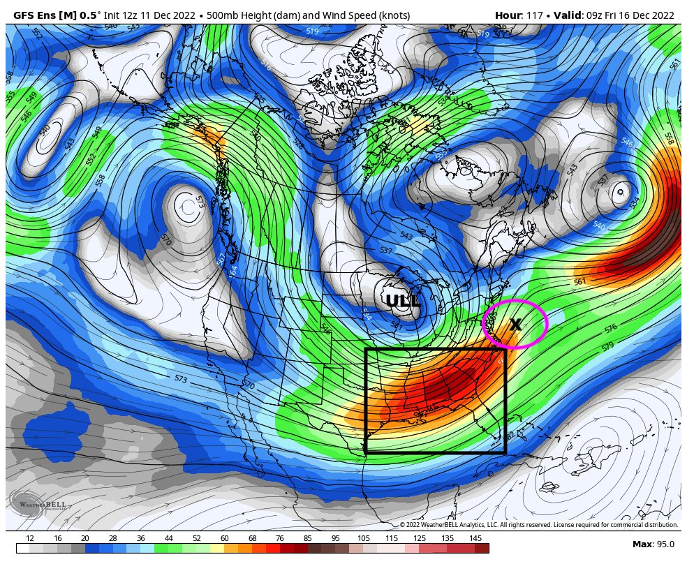
![]() by amugs Sun Dec 11, 2022 12:58 pm
by amugs Sun Dec 11, 2022 12:58 pm
Sharper Ridge out west, jet streak much further so the Surface LP is around where the x marks the spot..benchmark, 50/50 LP and NAO block and AO. If you want to see a snowstorm along I95 this is what you want as your set up. The oprational should catch up to this idea.
My thoughts are not wavering on this nor the pattern thorugh until the 1st week of January before we relax it. Models are to quick to break it down IMO. Jan thaw then a fierce reload that may last through midish March even early April. Time will tell with all.
_________________
Mugs
AKA:King: Snow Weenie
Self Proclaimed
WINTER 2014-15 : 55.12" +.02 for 6 coatings (avg. 35")
WINTER 2015-16 Total - 29.8" (Avg 35")
WINTER 2016-17 : 39.5" so far
amugs- Advanced Forecaster - Mod
- Posts : 15093
Reputation : 213
Join date : 2013-01-07
Age : 54
Location : Hillsdale,NJ
Page 10 of 40 • 1 ... 6 ... 9, 10, 11 ... 25 ... 40 ![]()
|
|
|