Long Range Thread 25.0
+42
toople
Coachgriff
Carvin
Scullybutcher
Wheezer
lglickman1
dolphins222
Grselig
Zhukov1945
aiannone
CPcantmeasuresnow
jimv45
JT33
TheAresian
Radz
brownie
SENJsnowman
billg315
hyde345
SoulSingMG
Math23x7
phil155
snowbunny
mmanisca
Abba701
MattyICE
GreyBeard
nutleyblizzard
heehaw453
weatherwatchermom
HectorO
jmanley32
Irish
dkodgis
Dunnzoo
sroc4
algae888
Frank_Wx
kalleg
frank 638
docstox12
amugs
46 posters
Page 6 of 40
Page 6 of 40 •  1 ... 5, 6, 7 ... 23 ... 40
 Re: Long Range Thread 25.0
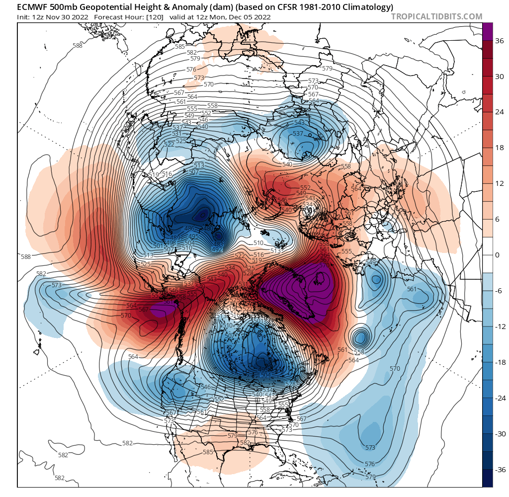
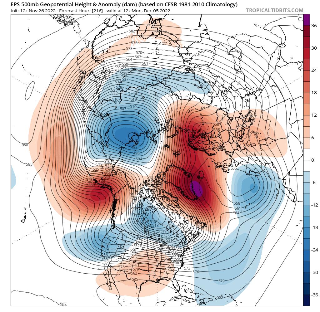
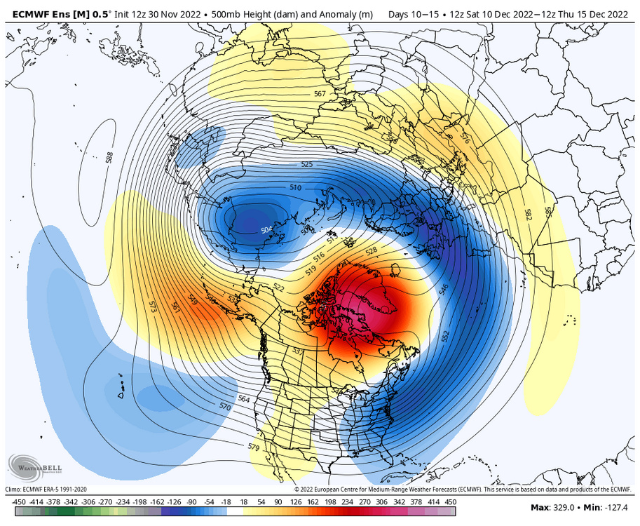
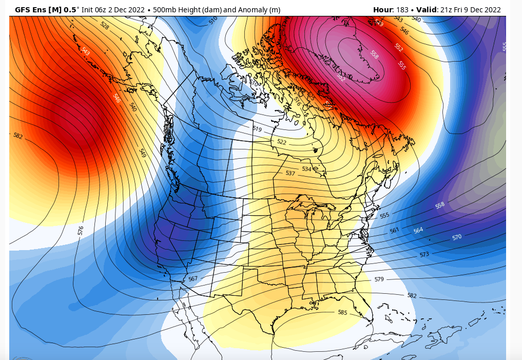
If this doesn't excite you folks the pure evolution of the pattern is remarkable so far. The models are seeing both blocks and strengthening them - the EPO is getting stronger and eroding, splitting the PNA negative - great sign there and the N AO and Greenie Blocks are stronger.
I said before something bellies under the 7-8th time frame.

I said before something bellies under the 7-8th time frame.

amugs- Advanced Forecaster - Mod

- Posts : 15130
Join date : 2013-01-07
kalleg likes this post
 Re: Long Range Thread 25.0
This Split flow jet extension in the PAC off Japan would be a great sign for the 16-25th time frame BUT mega years before then. This sin itself would reshuffle the Pac to a MUCH more favorable pattern.
From 33nRain Nick Psomaris

From 33nRain Nick Psomaris

amugs- Advanced Forecaster - Mod

- Posts : 15130
Join date : 2013-01-07
 Re: Long Range Thread 25.0
WOW at the pattern bieng depictedby the models and there'sno end in sight. December2010 is a great match. -enso, identical qbo and similar pdo. We got 60" that year from late Decemberthru feb 1st. As mugs says buckle up we're in for quite a ride.
"This will not be the last NAO block, and the reemergence of the k=1 CHI mid month (MJO) will help continue the feedback loop between tropical forcing and Scand/NAO blocking into January. The background state remains favorable for at least another block after the first round. "
"
Anthony Masiello
@antmasiello
·
"Follow
Once the MJO on the RMMs becomes coherent again, is when the Walker Uplift returns next week. This will work in tandem with the NE Siberian quasi-stationary wave and produce the next wave train that amplifies the EPO/Scand. And on and on it goes until something stops it."
From Anthony massiello
"This will not be the last NAO block, and the reemergence of the k=1 CHI mid month (MJO) will help continue the feedback loop between tropical forcing and Scand/NAO blocking into January. The background state remains favorable for at least another block after the first round.
Anthony Masiello
@antmasiello
·
"Follow
Once the MJO on the RMMs becomes coherent again, is when the Walker Uplift returns next week. This will work in tandem with the NE Siberian quasi-stationary wave and produce the next wave train that amplifies the EPO/Scand. And on and on it goes until something stops it."
From Anthony massiello

algae888- Advanced Forecaster

- Posts : 5311
Reputation : 46
Join date : 2013-02-05
Age : 62
Location : mt. vernon, new york

algae888- Advanced Forecaster

- Posts : 5311
Reputation : 46
Join date : 2013-02-05
Age : 62
Location : mt. vernon, new york

algae888- Advanced Forecaster

- Posts : 5311
Reputation : 46
Join date : 2013-02-05
Age : 62
Location : mt. vernon, new york

algae888- Advanced Forecaster

- Posts : 5311
Reputation : 46
Join date : 2013-02-05
Age : 62
Location : mt. vernon, new york

algae888- Advanced Forecaster

- Posts : 5311
Reputation : 46
Join date : 2013-02-05
Age : 62
Location : mt. vernon, new york
 Re: Long Range Thread 25.0
Al, did u see last page what I was saying about the EPO press as it's getting stronger and the models are starting to recognize this . Ala 13-14, 14-15 when the EPO dominated the pattern.
That press will cause the vortex to travel under the belly as we say than cut. I would like to see this trend continue the next couple of days.
The EPS is just amazing as you posted.
Great stuff!!
Rb?? Where are you be???
That press will cause the vortex to travel under the belly as we say than cut. I would like to see this trend continue the next couple of days.
The EPS is just amazing as you posted.
Great stuff!!
Rb?? Where are you be???
_________________
Mugs
AKA:King: Snow Weenie
Self Proclaimed
WINTER 2014-15 : 55.12" +.02 for 6 coatings (avg. 35")
WINTER 2015-16 Total - 29.8" (Avg 35")
WINTER 2016-17 : 39.5" so far

amugs- Advanced Forecaster - Mod

- Posts : 15130
Reputation : 213
Join date : 2013-01-07
Age : 54
Location : Hillsdale,NJ

Irish- Pro Enthusiast

- Posts : 788
Reputation : 19
Join date : 2019-01-16
Age : 46
Location : Old Bridge, NJ
 Re: Long Range Thread 25.0
Yes. The blocking here is a potentially record-breaking -NAO which here is also bleeding into the AO domain as well. This will continue to back up the flow and allow for more western ridging and eastern troughing. Plain and simple this pattern of a retrograding high latitude block is frequently a pre-loading pattern that CAN yield significant to major snow events for the northeast
MattyICE- Advanced Forecaster

- Posts : 249
Reputation : 6
Join date : 2017-11-10
Age : 39
Location : Clifton, NJ (Eastern Passaic County)
docstox12, amugs, essexcountypete, weatherwatchermom and Irish like this post
 Re: Long Range Thread 25.0
MattyICE wrote:
Yes. The blocking here is a potentially record-breaking -NAO which here is also bleeding into the AO domain as well. This will continue to back up the flow and allow for more western ridging and eastern troughing. Plain and simple this pattern of a retrograding high latitude block is frequently a pre-loading pattern that CAN yield significant to major snow events for the northeast
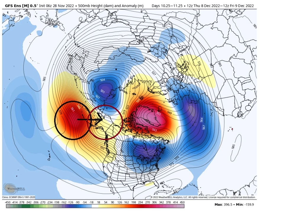
Excellent Matty ICE and if I may add it also shows the heights over the arctic with high pressures and the elusive ridge bridge the bforms over the arctic which means the Greenland block (NAO = North Atlantic Oscillation) and the the Aluetian Vortex by Alaska (EPO = East Pacific Oscillayion) are connecting. This means that the cold arctic air gets pushed down into the lower 48 and Canada. The west coast ridge called the PNA is positive which helps buckle the flow and helps direct, guide storms up the eastern seaboard region. The trough, in blue is an almost global full lattitude trough which is also impprtant becasue the cold air gets locked in from the US all the way thorugh Europe and into Asia.
I hope this all helps. And lastly when teh NAO block starts to erode, elongate and weaken is when we have seen MECS - major east coast storms of 12" or more in thsi region. Not a guarentee but noteworthy to keep an eye on. The prognostication and research shows it is usually occurs when the NAO reaches a a standard deviation negative level of 1-1.5~7 days after the block reaches its full strength that these storm occur which bring us to the 12/15-22 timeframe.
_________________
Mugs
AKA:King: Snow Weenie
Self Proclaimed
WINTER 2014-15 : 55.12" +.02 for 6 coatings (avg. 35")
WINTER 2015-16 Total - 29.8" (Avg 35")
WINTER 2016-17 : 39.5" so far

amugs- Advanced Forecaster - Mod

- Posts : 15130
Reputation : 213
Join date : 2013-01-07
Age : 54
Location : Hillsdale,NJ
MattyICE likes this post
 Re: Long Range Thread 25.0
Gosh my cable and electric companies texted me today; both warned me of severe weather Sat. Here I was thinking of the big night-time temp drops by next weekend. Right now it is about Sat? Heavy rain? Wind?

dkodgis- Senior Enthusiast

- Posts : 2661
Reputation : 98
Join date : 2013-12-29
 Re: Long Range Thread 25.0
dkodgis wrote:Gosh my cable and electric companies texted me today; both warned me of severe weather Sat. Here I was thinking of the big night-time temp drops by next weekend. Right now it is about Sat? Heavy rain? Wind?
Think it is wind Damian, NWS has gusts over 30 MPH.

docstox12- Wx Statistician Guru

- Posts : 8589
Reputation : 222
Join date : 2013-01-07
Age : 73
Location : Monroe NY
 Re: Long Range Thread 25.0
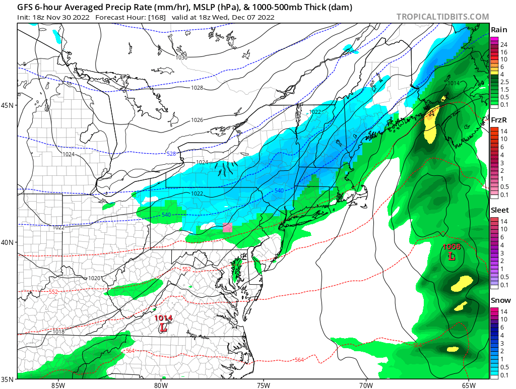
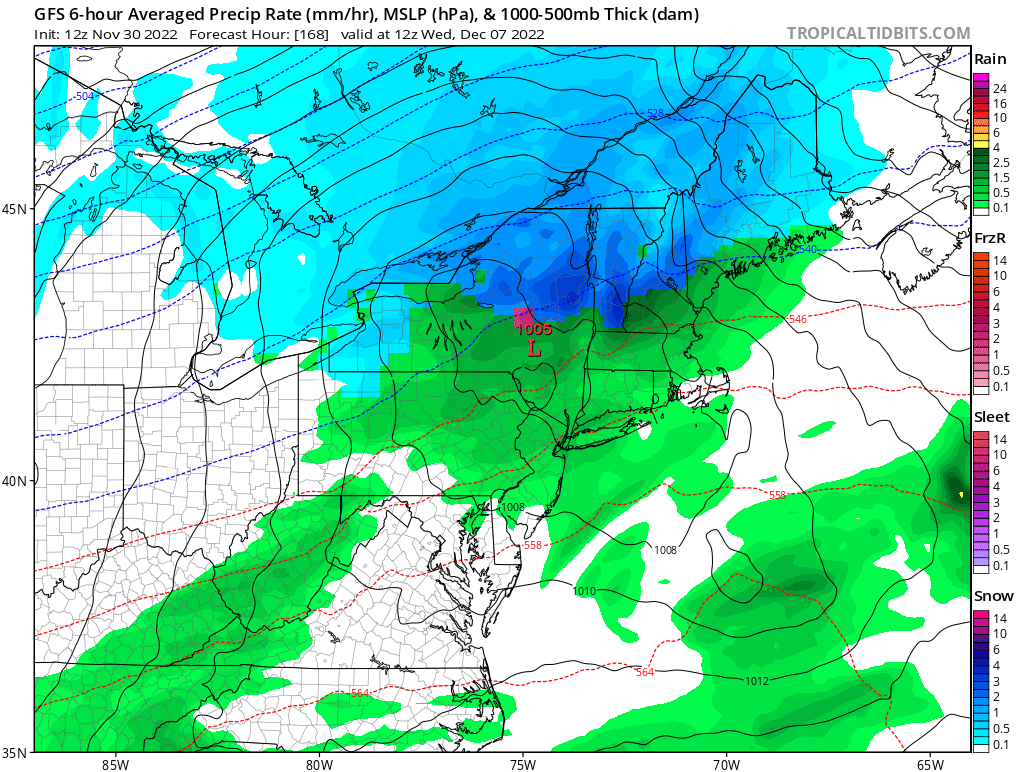
The last 2 GFS runs has the warm weather continuing. Just rain and warm temperatures continuing.
Abba701- Posts : 328
Reputation : 0
Join date : 2013-01-14
 Re: Long Range Thread 25.0
Abba701 wrote:The last 2 GFS runs has the warm weather continuing. Just rain and warm temperatures continuing.
That’s fine. Models notoriously have a hard time during big change periods like this. It’s expected to see major shifts, especially on single, operational runs. The ensembles are the way to go this far out, and even they will struggle more than normal, but they’re still better at this lead time. These fluctuations are expected and all a part of the process.
MattyICE- Advanced Forecaster

- Posts : 249
Reputation : 6
Join date : 2017-11-10
Age : 39
Location : Clifton, NJ (Eastern Passaic County)
 Re: Long Range Thread 25.0
It shows the same pattern continuing and 50,s and 60,s on some days. 06z had the cold settling in, 12z and 18z just the same pattern like now.
Abba701- Posts : 328
Reputation : 0
Join date : 2013-01-14
heehaw453- Advanced Forecaster

- Posts : 3907
Reputation : 86
Join date : 2014-01-20
Location : Bedminster Township, PA Elevation 600' ASL
 Re: Long Range Thread 25.0
At work but I'm just not sure the pattern will be mature enough by then. Will try and elaborate this weekend. Bottom line -PNA, Pac jet and STJ combined with the west coast alignment just doesnt look ready to support white or even significant cyclogenesis
_________________
"In weather and in life, there's no winning and losing; there's only winning and learning."
WINTER 2012/2013 TOTALS 43.65"WINTER 2017/2018 TOTALS 62.85" WINTER 2022/2023 TOTALS 4.9"
WINTER 2013/2014 TOTALS 64.85"WINTER 2018/2019 TOTALS 14.25" WINTER 2023/2024 TOTALS 13.1"
WINTER 2014/2015 TOTALS 71.20"WINTER 2019/2020 TOTALS 6.35"
WINTER 2015/2016 TOTALS 35.00"WINTER 2020/2021 TOTALS 37.75"
WINTER 2016/2017 TOTALS 42.25"WINTER 2021/2022 TOTALS 31.65"

sroc4- Admin

- Posts : 8441
Reputation : 302
Join date : 2013-01-07
Location : Wading River, LI
 Re: Long Range Thread 25.0
I agree. When looking at latest SOI value of 15 it's not an active subtropical jet and the PNA is negative. But it's noted the PNA is not a -5 sigma, but about -1.5 and will take at least to mid-month to get it linked up with the retrograding blocking. It's not a shutout pattern after 12/9 IMO (minor/moderate chances) but certainly intense cyclogenesis is very unlikely until/if the blocking links up with the PNA. It's also noted that 2010 blocking didn't really snow in these parts until BD blizzard. We just need the right wave spacing after 12/9 and I think the blocking will do its thing to give us some modest snows.sroc4 wrote:
At work but I'm just not sure the pattern will be mature enough by then. Will try and elaborate this weekend. Bottom line -PNA, Pac jet and STJ combined with the west coast alignment just doesnt look ready to support white or even significant cyclogenesis
heehaw453- Advanced Forecaster

- Posts : 3907
Reputation : 86
Join date : 2014-01-20
Location : Bedminster Township, PA Elevation 600' ASL
 Re: Long Range Thread 25.0
heehaw453 wrote:I agree. When looking at latest SOI value of 15 it's not an active subtropical jet and the PNA is negative. But it's noted the PNA is not a -5 sigma, but about -1.5 and will take at least to mid-month to get it linked up with the retrograding blocking. It's not a shutout pattern after 12/9 IMO (minor/moderate chances) but certainly intense cyclogenesis is very unlikely until/if the blocking links up with the PNA. It's also noted that 2010 blocking didn't really snow in these parts until BD blizzard. We just need the right wave spacing after 12/9 and I think the blocking will do its thing to give us some modest snows.sroc4 wrote:
At work but I'm just not sure the pattern will be mature enough by then. Will try and elaborate this weekend. Bottom line -PNA, Pac jet and STJ combined with the west coast alignment just doesnt look ready to support white or even significant cyclogenesis
I hope we’re not seeing this December turning into another mild one like last December was. I hate when the pattern looks like it keeps building the trough to our west.

mmanisca- Pro Enthusiast

- Posts : 299
Reputation : 3
Join date : 2013-01-23
Age : 65
Location : Deer Park, Long Island
 Re: Long Range Thread 25.0
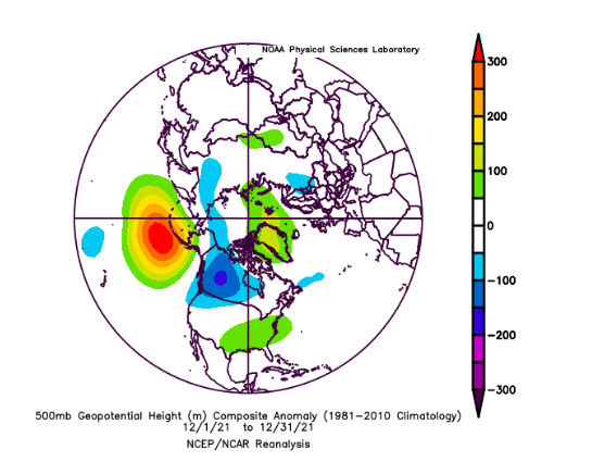
I get your concern. This was last December at the z500 and this is EPS progged D9 z500. It's at the point where the block starts to retrograde that should help clean up the PNA region. I like after 10th, but could it be delayed? Sure, just don't think we are dealing with a really bad base state of the PNA like last year and the blocking is much stronger and in a better spot. You can see December 2021 the PNA just plugged up the cross polar flow and allowed the SE ridge to flex more, but if not for HL blocking last year temps would have been > 5 AN instead of 2-3 AN. I still like a period of very wintry conditions in December...mmanisca wrote:heehaw453 wrote:I agree. When looking at latest SOI value of 15 it's not an active subtropical jet and the PNA is negative. But it's noted the PNA is not a -5 sigma, but about -1.5 and will take at least to mid-month to get it linked up with the retrograding blocking. It's not a shutout pattern after 12/9 IMO (minor/moderate chances) but certainly intense cyclogenesis is very unlikely until/if the blocking links up with the PNA. It's also noted that 2010 blocking didn't really snow in these parts until BD blizzard. We just need the right wave spacing after 12/9 and I think the blocking will do its thing to give us some modest snows.sroc4 wrote:
At work but I'm just not sure the pattern will be mature enough by then. Will try and elaborate this weekend. Bottom line -PNA, Pac jet and STJ combined with the west coast alignment just doesnt look ready to support white or even significant cyclogenesis
I hope we’re not seeing this December turning into another mild one like last December was. I hate when the pattern looks like it keeps building the trough to our west.
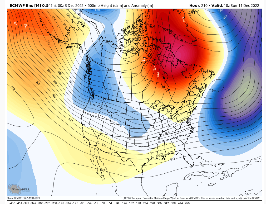
heehaw453- Advanced Forecaster

- Posts : 3907
Reputation : 86
Join date : 2014-01-20
Location : Bedminster Township, PA Elevation 600' ASL
 Thanks for the update, I see the difference in the poles in the comparison you put up! Does give some hope. Lol every December my mind goes back to ‘96 either crazy snow we had and the truly White Christmas that came along with it.
heehaw453 wrote:I get your concern. This was last December at the z500 and this is EPS progged D9 z500. It's at the point where the block starts to retrograde that should help clean up the PNA region. I like after 10th, but could it be delayed? Sure, just don't think we are dealing with a really bad base state of the PNA like last year and the blocking is much stronger and in a better spot. You can see December 2021 the PNA just plugged up the cross polar flow and allowed the SE ridge to flex more, but if not for HL blocking last year temps would have been > 5 AN instead of 2-3 AN. I still like a period of very wintry conditions in December...mmanisca wrote:heehaw453 wrote:I agree. When looking at latest SOI value of 15 it's not an active subtropical jet and the PNA is negative. But it's noted the PNA is not a -5 sigma, but about -1.5 and will take at least to mid-month to get it linked up with the retrograding blocking. It's not a shutout pattern after 12/9 IMO (minor/moderate chances) but certainly intense cyclogenesis is very unlikely until/if the blocking links up with the PNA. It's also noted that 2010 blocking didn't really snow in these parts until BD blizzard. We just need the right wave spacing after 12/9 and I think the blocking will do its thing to give us some modest snows.sroc4 wrote:
At work but I'm just not sure the pattern will be mature enough by then. Will try and elaborate this weekend. Bottom line -PNA, Pac jet and STJ combined with the west coast alignment just doesnt look ready to support white or even significant cyclogenesis
I hope we’re not seeing this December turning into another mild one like last December was. I hate when the pattern looks like it keeps building the trough to our west.

mmanisca- Pro Enthusiast

- Posts : 299
Reputation : 3
Join date : 2013-01-23
Age : 65
Location : Deer Park, Long Island
 Re: Long Range Thread 25.0
sroc4 wrote:amugs wrote:The PNA goes neutral to slightly Positive - big win if it occurs for snow chances to the coastal plain. We have a stout Negative NAO (greenLand Block) and a Aluetian Block (Negative EPO) with a piece of the PV sitting over Hudson Bay. A very nice set up again IF it comes to fruitoin - we have all 3 globals saying so at this time.
This really doesn't look like a true -EPO alignment. IMO the Ridge needs to be N of the Aleutian Islands. So long as it is south of the Aleutians this will promote the tendency to place a trough along the WC of Canada and N CONUS and Pac energy will be constantly bombarding any attempted pos PNA spike. We need that ridge centered more over Alaska or at least over the Bering Sea, rather than south of the islands.
OK. Here are my concerns for most of the month of December. I had to recall my comments from Monday of this past week because really the importance of this one area of the northern Pac cant be understated IMHO. (See bolded above).
First lets comment on the NAO. We all know that prospects of a negative NAO is typically a snow lovers dream. We know that in recent discussions in here and around the weather community there is an almost unprecedented negative NAO in the making setting up for the month of December which has sparked giddiness and excitement at the potential for white in the NE setting up for this month as a result. But Im concerned we may be building too big of an expectation on how the developing -NAO is actually going to play out for the month of December.
Time and time again we look at things like ensemble forecasts projecting in the long range, ie: 10-14days and beyond, recognizing what appears to be the potential for a phenomenal pattern setting up only to have things evolve less than ideal as we begin to get closer in time as the spread of the ensembles begin to tighten and the details come into focus and the let down ensues. Year after year we run into these sorts of moments. Im worried that we may have jumped the gun yet again an hre is why.
Again recall the bolded comment above from the discussion earlier in the week. So long as we have strong positives(ridging) dominating the area south of the Aleutian islands we are going to have negatives(trough) along the west coast of North America(NA) to varying degrees. These leads to negative PNA and or negative EPO. Stated more accurately this leads to weakness in the west that allows our cold air to hang back and our SE ridge to flex. Let me show you what I mean.
Below is depicting the 500mb pattern valid for tomorrow afternoon. What this illustrates is that when you have a trough south of the Aleutian Islands you get ridging extending into Alaska (-EPO). Combined with the -NAO this pinches the Polar Vortex (PV) and forces it south and east centered around the Hudson Bay. This as forecasted verbatim brings the cold air very close to the NE and is what we want to see. Note however that the trough in the SE CONUS, -PNA, still brings the Pac jet and STJ across the majority of the CONUS. Whre is our air mass coming from? The jet stream pattern will tell you.

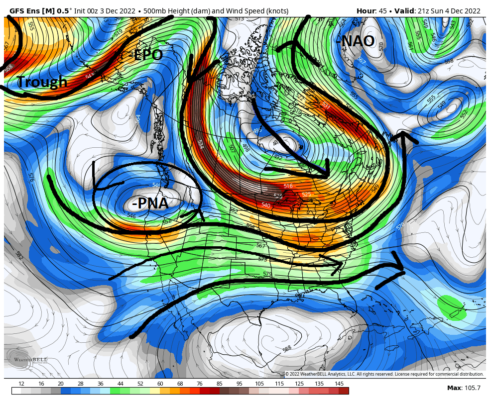
Now if the trough south of the Aleutians and the ridging over Alaska were to persist along with the -NAO the cold air would keep punching and punching its way into the NE creating a boundary layer that sits south of us setting us up for decent snow chances. BUT what appears to now be consistently forecasted in the ensembles is that the prev noted ridging I was concerned wants to retrograde and settle back in south of the Aleutians replacing the trough and we once again get negatives develop over Alaska and consequentially along the WC of Canada. This allows the PV to retrograde and drift westward which eases up on the pressure of the cold press on the SE ridge which allows the SE ridge to flex once again.
As you can see below by About Wednesday eve this takes place and the upper level pattern shifts back to a mod La Nina type pattern. With the Pac side not pushing hard enough the strong -NAO pushes the bulk of the cold air back into the west where it appears to stay through most of the foreseeable future.

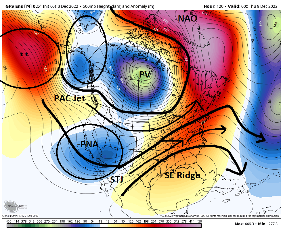

This next image is the forecast for Saturday evening. As you can see a similar relative alignment of most of these key features.

And here is the last frame of the 00z GEFS ensemble forecast valid for approx Saturday December 18th.

This last image is 15days from now so there is alot of spread in this forecast. Will we see the evolution begin to place the ridge south of the Aleutians again, or will it shift east and or N a bit bringing the PV back east and or S again towards our region? Will the SW CONUS cont to support a trough, -PNA, or will it retrograde back into the PAC which might allow a +PNA to show up? Not sure yet about that but the way it seems now this is the pattern we are in. The MJO forecast is currently in the Null phase(circle of death, and looks to remain there fore a little bit. When if at all, and more importantly where, which phase, it decides to re-emerge into is still up in the air. This means there isnt much of an influence of the MJO on the overall pattern, such that the base state of La Nina to be a driving force.
I mean Im not saying that we wont get any snow chances, esp off the coastal plain, but I am concerned that the calls for BN temps for the month will bust and the possibility of a swing and miss for snow for the month legitimately exists, at least through the next 15-20days. We shall see.
_________________
"In weather and in life, there's no winning and losing; there's only winning and learning."
WINTER 2012/2013 TOTALS 43.65"WINTER 2017/2018 TOTALS 62.85" WINTER 2022/2023 TOTALS 4.9"
WINTER 2013/2014 TOTALS 64.85"WINTER 2018/2019 TOTALS 14.25" WINTER 2023/2024 TOTALS 13.1"
WINTER 2014/2015 TOTALS 71.20"WINTER 2019/2020 TOTALS 6.35"
WINTER 2015/2016 TOTALS 35.00"WINTER 2020/2021 TOTALS 37.75"
WINTER 2016/2017 TOTALS 42.25"WINTER 2021/2022 TOTALS 31.65"

sroc4- Admin

- Posts : 8441
Reputation : 302
Join date : 2013-01-07
Location : Wading River, LI
heehaw453 likes this post
 Re: Long Range Thread 25.0
And the pull back from optimism begins...

Irish- Pro Enthusiast

- Posts : 788
Reputation : 19
Join date : 2019-01-16
Age : 46
Location : Old Bridge, NJ
 Re: Long Range Thread 25.0
Irish wrote:And the pull back from optimism begins...
Nah. Pulling back off from blind optimism. Back to about cautious optimism. Btw hats off on the Cowgirls win.
_________________
"In weather and in life, there's no winning and losing; there's only winning and learning."
WINTER 2012/2013 TOTALS 43.65"WINTER 2017/2018 TOTALS 62.85" WINTER 2022/2023 TOTALS 4.9"
WINTER 2013/2014 TOTALS 64.85"WINTER 2018/2019 TOTALS 14.25" WINTER 2023/2024 TOTALS 13.1"
WINTER 2014/2015 TOTALS 71.20"WINTER 2019/2020 TOTALS 6.35"
WINTER 2015/2016 TOTALS 35.00"WINTER 2020/2021 TOTALS 37.75"
WINTER 2016/2017 TOTALS 42.25"WINTER 2021/2022 TOTALS 31.65"

sroc4- Admin

- Posts : 8441
Reputation : 302
Join date : 2013-01-07
Location : Wading River, LI
 Re: Long Range Thread 25.0
sroc4 wrote:Irish wrote:And the pull back from optimism begins...
Nah. Pulling back off from blind optimism. Back to about cautious optimism. Btw hats off on the Cowgirls win.
I see, makes sense. Thank you, definitely a good win. Eagles have the division right now but I think we can beat them, at the very least, compete with them.

Irish- Pro Enthusiast

- Posts : 788
Reputation : 19
Join date : 2019-01-16
Age : 46
Location : Old Bridge, NJ
sroc4 likes this post
 Re: Long Range Thread 25.0
The voice of reasonsroc4 wrote:Irish wrote:And the pull back from optimism begins...
Nah. Pulling back off from blind optimism. Back to about cautious optimism. Btw hats off on the Cowgirls win.
heehaw453- Advanced Forecaster

- Posts : 3907
Reputation : 86
Join date : 2014-01-20
Location : Bedminster Township, PA Elevation 600' ASL
sroc4 and MattyICE like this post
Page 6 of 40 •  1 ... 5, 6, 7 ... 23 ... 40
Page 6 of 40
Permissions in this forum:
You cannot reply to topics in this forum|
|
|

 Home
Home