
 Search
Long Range Thread 25.0
Page 23 of 40 •  1 ... 13 ... 22, 23, 24 ... 31 ... 40
 ![]()
Re: Long Range Thread 25.0
![]() by frank 638 Thu Jan 05, 2023 4:56 pm
by frank 638 Thu Jan 05, 2023 4:56 pm
frank 638- Senior Enthusiast

- Posts : 2824
Join date : 2016-01-01
Re: Long Range Thread 25.0
![]() by heehaw453 Thu Jan 05, 2023 5:14 pm
by heehaw453 Thu Jan 05, 2023 5:14 pm


heehaw453- Advanced Forecaster

- Posts : 3906
Join date : 2014-01-20
amugs likes this post
Re: Long Range Thread 25.0
![]() by amugs Thu Jan 05, 2023 8:17 pm
by amugs Thu Jan 05, 2023 8:17 pm
Just call me the EPS whisperer. https://t.co/rq9m5v2weY pic.twitter.com/hzQD3lCQ5N
— Judah Cohen (@judah47) January 5, 2023
_________________
Mugs
AKA:King: Snow Weenie
Self Proclaimed
WINTER 2014-15 : 55.12" +.02 for 6 coatings (avg. 35")
WINTER 2015-16 Total - 29.8" (Avg 35")
WINTER 2016-17 : 39.5" so far

amugs- Advanced Forecaster - Mod

- Posts : 15093
Reputation : 213
Join date : 2013-01-07
Age : 54
Location : Hillsdale,NJ
Re: Long Range Thread 25.0
![]() by lglickman1 Thu Jan 05, 2023 8:47 pm
by lglickman1 Thu Jan 05, 2023 8:47 pm
lglickman1- Pro Enthusiast

- Posts : 319
Reputation : 0
Join date : 2013-02-05
Location : New Rochelle, NY
Re: Long Range Thread 25.0
![]() by sroc4 Thu Jan 05, 2023 9:14 pm
by sroc4 Thu Jan 05, 2023 9:14 pm
lglickman1 wrote:If we have a sswe at the end of january , isn't there usually a 2 week delay till we see it effect our weather? That would bring us to mid February?
Give it take but yes. Usually
_________________
"In weather and in life, there's no winning and losing; there's only winning and learning."
WINTER 2012/2013 TOTALS 43.65"WINTER 2017/2018 TOTALS 62.85" WINTER 2022/2023 TOTALS 4.9"
WINTER 2013/2014 TOTALS 64.85"WINTER 2018/2019 TOTALS 14.25" WINTER 2023/2024 TOTALS 13.1"
WINTER 2014/2015 TOTALS 71.20"WINTER 2019/2020 TOTALS 6.35"
WINTER 2015/2016 TOTALS 35.00"WINTER 2020/2021 TOTALS 37.75"
WINTER 2016/2017 TOTALS 42.25"WINTER 2021/2022 TOTALS 31.65"

sroc4- Admin

- Posts : 8331
Reputation : 301
Join date : 2013-01-07
Location : Wading River, LI
Re: Long Range Thread 25.0
![]() by amugs Fri Jan 06, 2023 9:26 am
by amugs Fri Jan 06, 2023 9:26 am
frank 638 wrote:I was watching Lee goldberg at 445 and he was saying Next Thursday it’s going to get colder and we might have a nor’easter nearby. The way this winter is going I don’t believe it I know it will go out to sea or it’s going to be a rain storm
KOD whenver the pro TV mets start talking about these storms they go poof, time and time again they are the mush to our storms. Best storms are when they call 1-3" and we get 4-8" plus like SB snowstorms of 2014 and 2015!
This is what we want to see peeps from the MJO that will help drive the pattern
A rotation from P7 which isn't cold for Jan, but as we the wave marches through 8 and into 1 thats good for Jan - cold and stormy then 2 for Feb is the same as is 3

A 3 -4 wintry timeframe start the 15-18thish and going thorugh Feb midish. A quick pullback after next weekend then we settle in I'd say from late Jan 20this thorugh midish February. For our storm next weeekend if we want it to snow to the coast we want the GEFS and GFS quicker solution. If it is delayed, it holds back as Dr. No the Euro said yesterday then kiss that goodbye. What I mean is we want this storm to be here by Thursday if not I do not see it working if it gets here Friday late night or Saturday, that is our window.
Big time discussions over Stratosphere if it is a SSWE or just an elongation - time will tell.
_________________
Mugs
AKA:King: Snow Weenie
Self Proclaimed
WINTER 2014-15 : 55.12" +.02 for 6 coatings (avg. 35")
WINTER 2015-16 Total - 29.8" (Avg 35")
WINTER 2016-17 : 39.5" so far
amugs- Advanced Forecaster - Mod
- Posts : 15093
Reputation : 213
Join date : 2013-01-07
Age : 54
Location : Hillsdale,NJ
Re: Long Range Thread 25.0
![]() by heehaw453 Fri Jan 06, 2023 10:00 am
by heehaw453 Fri Jan 06, 2023 10:00 am


heehaw453- Advanced Forecaster
- Posts : 3906
Reputation : 86
Join date : 2014-01-20
Location : Bedminster Township, PA Elevation 600' ASL
Re: Long Range Thread 25.0
![]() by heehaw453 Fri Jan 06, 2023 11:08 am
by heehaw453 Fri Jan 06, 2023 11:08 am
heehaw453- Advanced Forecaster
- Posts : 3906
Reputation : 86
Join date : 2014-01-20
Location : Bedminster Township, PA Elevation 600' ASL
Re: Long Range Thread 25.0
![]() by heehaw453 Fri Jan 06, 2023 11:47 am
by heehaw453 Fri Jan 06, 2023 11:47 am

heehaw453- Advanced Forecaster
- Posts : 3906
Reputation : 86
Join date : 2014-01-20
Location : Bedminster Township, PA Elevation 600' ASL
Re: Long Range Thread 25.0
![]() by sroc4 Fri Jan 06, 2023 12:52 pm
by sroc4 Fri Jan 06, 2023 12:52 pm
heehaw453 wrote:That 50/50 ish low IMO is the key to 1/13-14. If that can pin strong H pressure in the right spot there's a shot. If this 50/50 is phantom then that H will be inclined to break down and slide much faster to provide a pathway for the storm to hug instead of BM.
I would not get your hopes up for a 50/50 low that holds on. Expect it along with the HP to the north to scoot along like it has been. There is nothing to the east or NE of the 50/50 location to make me think this system has time to mature and not be booted. On top of the that, as has been the case the entire time the west coast conts to be bombarded with system after system keeping our EC pattern progressive and on the move and destroying any ridge to our west. just look at what the 12z GFS tries to do today. What the actual F. By hr 162 we have a beautiful ridge whos axis is aligned through Nevada which perfect. You have a northern s/w digging into a southern s/w about to phase as it reaches the coast. And a temperature profile that has our 850 freezing line well to our south(green colors denotes the edge of the freezing line on the temp map below).
Honestly Id take this look 1000 out of 1000 times in January.


But ho;ld the damn phone. Its winter 2022/2023. By hr 219 after phasing the entire system cuts off from the mean flow and becomes an independent cutoff low. The polar jet stream and Pac and STJ all of a sudden become completely independent of one another and orient west to east in a zonal pattern, despite the fact that 2-3days prior we were totally meridional. This results in a flooding of the area with warm Pac and Sub tropical air and shifts thew 850mb freezing line well into Canada. Its like someone turned the screws and the literally shut off the closed air source. The only cold air you see is the cold air being pulled down vertically from the upper levels of the atmosphere because the cutoff low is a vortex of air coming to a central point. Mamma Mia if this happens. If it does its because once again the Pacific pattern blows upper Mongolian elk balls and there is no negative NAO slowing things down.


_________________
"In weather and in life, there's no winning and losing; there's only winning and learning."
WINTER 2012/2013 TOTALS 43.65"WINTER 2017/2018 TOTALS 62.85" WINTER 2022/2023 TOTALS 4.9"
WINTER 2013/2014 TOTALS 64.85"WINTER 2018/2019 TOTALS 14.25" WINTER 2023/2024 TOTALS 13.1"
WINTER 2014/2015 TOTALS 71.20"WINTER 2019/2020 TOTALS 6.35"
WINTER 2015/2016 TOTALS 35.00"WINTER 2020/2021 TOTALS 37.75"
WINTER 2016/2017 TOTALS 42.25"WINTER 2021/2022 TOTALS 31.65"
sroc4- Admin
- Posts : 8331
Reputation : 301
Join date : 2013-01-07
Location : Wading River, LI
Re: Long Range Thread 25.0
![]() by amugs Fri Jan 06, 2023 1:45 pm
by amugs Fri Jan 06, 2023 1:45 pm
one of the things old school mets taught me ( we are talking my dads generation) was the bathtub slosh idea of cold and warm. Classic taking place now. Euro weeklies show cold on Asia. A month from now flip. Hence concern about another severe 20 day period US pic.twitter.com/B8RbCSbnrU
— Joe Bastardi (@BigJoeBastardi) January 6, 2023
_________________
Mugs
AKA:King: Snow Weenie
Self Proclaimed
WINTER 2014-15 : 55.12" +.02 for 6 coatings (avg. 35")
WINTER 2015-16 Total - 29.8" (Avg 35")
WINTER 2016-17 : 39.5" so far
amugs- Advanced Forecaster - Mod
- Posts : 15093
Reputation : 213
Join date : 2013-01-07
Age : 54
Location : Hillsdale,NJ
Re: Long Range Thread 25.0
![]() by sroc4 Fri Jan 06, 2023 1:51 pm
by sroc4 Fri Jan 06, 2023 1:51 pm
amugs wrote:one of the things old school mets taught me ( we are talking my dads generation) was the bathtub slosh idea of cold and warm. Classic taking place now. Euro weeklies show cold on Asia. A month from now flip. Hence concern about another severe 20 day period US pic.twitter.com/B8RbCSbnrU
— Joe Bastardi (@BigJoeBastardi) January 6, 2023
Ill tell ya Mugs, the long range for the US has taken a beating with a ton of cold and snow this year. Wish we lived in the long range though. Lol. Sorry, my frustrations are spilling out a bit today.
_________________
"In weather and in life, there's no winning and losing; there's only winning and learning."
WINTER 2012/2013 TOTALS 43.65"WINTER 2017/2018 TOTALS 62.85" WINTER 2022/2023 TOTALS 4.9"
WINTER 2013/2014 TOTALS 64.85"WINTER 2018/2019 TOTALS 14.25" WINTER 2023/2024 TOTALS 13.1"
WINTER 2014/2015 TOTALS 71.20"WINTER 2019/2020 TOTALS 6.35"
WINTER 2015/2016 TOTALS 35.00"WINTER 2020/2021 TOTALS 37.75"
WINTER 2016/2017 TOTALS 42.25"WINTER 2021/2022 TOTALS 31.65"
sroc4- Admin
- Posts : 8331
Reputation : 301
Join date : 2013-01-07
Location : Wading River, LI
weatherwatchermom likes this post
Re: Long Range Thread 25.0
![]() by heehaw453 Fri Jan 06, 2023 1:55 pm
by heehaw453 Fri Jan 06, 2023 1:55 pm
I agree cut off ULLs are part of this winter's plan and if models are right now it'll cut off in the heartland and want to flood mid-levels with warmth. The shot I mean is front end stuff especially for the interior. With decent H then several inches can fall before it taints. No strong High, then no shot for anything but rain for everyone IMO.sroc4 wrote:heehaw453 wrote:That 50/50 ish low IMO is the key to 1/13-14. If that can pin strong H pressure in the right spot there's a shot. If this 50/50 is phantom then that H will be inclined to break down and slide much faster to provide a pathway for the storm to hug instead of BM.
I would not get your hopes up for a 50/50 low that holds on. Expect it along with the HP to the north to scoot along like it has been. There is nothing to the east or NE of the 50/50 location to make me think this system has time to mature and not be booted. On top of the that, as has been the case the entire time the west coast conts to be bombarded with system after system keeping our EC pattern progressive and on the move and destroying any ridge to our west. just look at what the 12z GFS tries to do today. What the actual F. By hr 162 we have a beautiful ridge whos axis is aligned through Nevada which perfect. You have a northern s/w digging into a southern s/w about to phase as it reaches the coast. And a temperature profile that has our 850 freezing line well to our south(green colors denotes the edge of the freezing line on the temp map below).
Honestly Id take this look 1000 out of 1000 times in January.
But ho;ld the damn phone. Its winter 2022/2023. By hr 219 after phasing the entire system cuts off from the mean flow and becomes an independent cutoff low. The polar jet stream and Pac and STJ all of a sudden become completely independent of one another and orient west to east in a zonal pattern, despite the fact that 2-3days prior we were totally meridional. This results in a flooding of the area with warm Pac and Sub tropical air and shifts thew 850mb freezing line well into Canada. Its like someone turned the screws and the literally shut off the closed air source. The only cold air you see is the cold air being pulled down vertically from the upper levels of the atmosphere because the cutoff low is a vortex of air coming to a central point. Mamma Mia if this happens. If it does its because once again the Pacific pattern blows upper Mongolian elk balls and there is no negative NAO slowing things down.


If this is going to work we have to hope our system does not close off too early. If it does..coastal hugger it will be.
heehaw453- Advanced Forecaster
- Posts : 3906
Reputation : 86
Join date : 2014-01-20
Location : Bedminster Township, PA Elevation 600' ASL
Re: Long Range Thread 25.0
![]() by sroc4 Fri Jan 06, 2023 1:58 pm
by sroc4 Fri Jan 06, 2023 1:58 pm
_________________
"In weather and in life, there's no winning and losing; there's only winning and learning."
WINTER 2012/2013 TOTALS 43.65"WINTER 2017/2018 TOTALS 62.85" WINTER 2022/2023 TOTALS 4.9"
WINTER 2013/2014 TOTALS 64.85"WINTER 2018/2019 TOTALS 14.25" WINTER 2023/2024 TOTALS 13.1"
WINTER 2014/2015 TOTALS 71.20"WINTER 2019/2020 TOTALS 6.35"
WINTER 2015/2016 TOTALS 35.00"WINTER 2020/2021 TOTALS 37.75"
WINTER 2016/2017 TOTALS 42.25"WINTER 2021/2022 TOTALS 31.65"
sroc4- Admin
- Posts : 8331
Reputation : 301
Join date : 2013-01-07
Location : Wading River, LI
Re: Long Range Thread 25.0
![]() by heehaw453 Fri Jan 06, 2023 2:15 pm
by heehaw453 Fri Jan 06, 2023 2:15 pm
This is not a bad setup even though the outcome may eventually sucksroc4 wrote:Cant disagree with what your saying. Problem is is when these things cutoff from the mean flow to our north, the system slows down, while the key ingredients, ie: 50/50 low and HP to the N, keep right on moving. This set up specifically looks like it cuts off early and slows down, and the Polar jet screams over head effectively shutting the valve to any access to cold air from the cutoff low. I hope Im wrong.
It's possible an energy transfers occurs quickly to the coast. Then as long as an axis tilt isn't already leaning negative the storm has a shot for BM. But I get it it's been a brutal season so far for snow lovers and certainly this storm doesn't have high probability to ease that. I've seen a lot worse 8+ days out produce in January.
heehaw453- Advanced Forecaster
- Posts : 3906
Reputation : 86
Join date : 2014-01-20
Location : Bedminster Township, PA Elevation 600' ASL
Re: Long Range Thread 25.0
![]() by heehaw453 Fri Jan 06, 2023 2:36 pm
by heehaw453 Fri Jan 06, 2023 2:36 pm

heehaw453- Advanced Forecaster
- Posts : 3906
Reputation : 86
Join date : 2014-01-20
Location : Bedminster Township, PA Elevation 600' ASL
Re: Long Range Thread 25.0
![]() by sroc4 Fri Jan 06, 2023 5:58 pm
by sroc4 Fri Jan 06, 2023 5:58 pm
heehaw453 wrote:Definitely lots of huggers and an early close off scenario on the EPS. 8+ days out, so let us see how it looks in a few days.
Agreed. My frustrations got the better of me today. Glass is also half full and we are a week out. Never has it been the final soln this far out. Ill give it through the weekend bfore I revisit the empty half of the glass again. lol
_________________
"In weather and in life, there's no winning and losing; there's only winning and learning."
WINTER 2012/2013 TOTALS 43.65"WINTER 2017/2018 TOTALS 62.85" WINTER 2022/2023 TOTALS 4.9"
WINTER 2013/2014 TOTALS 64.85"WINTER 2018/2019 TOTALS 14.25" WINTER 2023/2024 TOTALS 13.1"
WINTER 2014/2015 TOTALS 71.20"WINTER 2019/2020 TOTALS 6.35"
WINTER 2015/2016 TOTALS 35.00"WINTER 2020/2021 TOTALS 37.75"
WINTER 2016/2017 TOTALS 42.25"WINTER 2021/2022 TOTALS 31.65"
sroc4- Admin
- Posts : 8331
Reputation : 301
Join date : 2013-01-07
Location : Wading River, LI
docstox12, crippo84, heehaw453 and SENJsnowman like this post
Re: Long Range Thread 25.0
![]() by heehaw453 Fri Jan 06, 2023 6:09 pm
by heehaw453 Fri Jan 06, 2023 6:09 pm


heehaw453- Advanced Forecaster
- Posts : 3906
Reputation : 86
Join date : 2014-01-20
Location : Bedminster Township, PA Elevation 600' ASL
Re: Long Range Thread 25.0
![]() by Irish Fri Jan 06, 2023 9:57 pm
by Irish Fri Jan 06, 2023 9:57 pm

Irish- Pro Enthusiast
- Posts : 788
Reputation : 19
Join date : 2019-01-16
Age : 45
Location : Old Bridge, NJ
Re: Long Range Thread 25.0
![]() by heehaw453 Sat Jan 07, 2023 11:43 am
by heehaw453 Sat Jan 07, 2023 11:43 am


heehaw453- Advanced Forecaster
- Posts : 3906
Reputation : 86
Join date : 2014-01-20
Location : Bedminster Township, PA Elevation 600' ASL
Re: Long Range Thread 25.0
![]() by heehaw453 Sat Jan 07, 2023 12:08 pm
by heehaw453 Sat Jan 07, 2023 12:08 pm

heehaw453- Advanced Forecaster
- Posts : 3906
Reputation : 86
Join date : 2014-01-20
Location : Bedminster Township, PA Elevation 600' ASL
Re: Long Range Thread 25.0
![]() by Frank_Wx Sat Jan 07, 2023 12:49 pm
by Frank_Wx Sat Jan 07, 2023 12:49 pm
Unfortunately our pattern is not conducive for cold and snow to the coast right now. I said earlier we’ll need to wait until the final week of January. I’m beginning to feel more confident about that. However, keep in mind it will be a gradual pattern change. I think around the 25th or so we see the EPO/PNA regions greatly improve, and then the NAO will come back at some point in early February. But even with just the Pacific improving it will greatly help our chances to see wintry weather.
What I can’t figure out yet is whether this pattern change has staying power that would keep us cold into March, or is it just a 2-week thing. I think February will be pretty cold and active regardless
_________________
_______________________________________________________________________________________________________
CLICK HERE to view NJ Strong Snowstorm Classifications

Frank_Wx- Godzilla Seeker
- Posts : 21305
Reputation : 328
Join date : 2013-01-05
Age : 31
Location : Jersey City, NJ -

Re: Long Range Thread 25.0
![]() by heehaw453 Sat Jan 07, 2023 1:18 pm
by heehaw453 Sat Jan 07, 2023 1:18 pm
IMO the long wave pattern and synoptic setup for next week is conducive for a snow storm right to the coast, but the issue is the lack of cold air. When 850's are above 0 right into MN, WI that's a problem for us hoping we can maintain cold air here. Unless there is some PV shift I see that being a problem this entire winter quite honestly.Frank_Wx wrote:Euro shows a boatload of rain for the possible storm next week
Unfortunately our pattern is not conducive for cold and snow to the coast right now. I said earlier we’ll need to wait until the final week of January. I’m beginning to feel more confident about that. However, keep in mind it will be a gradual pattern change. I think around the 25th or so we see the EPO/PNA regions greatly improve, and then the NAO will come back at some point in early February. But even with just the Pacific improving it will greatly help our chances to see wintry weather.
What I can’t figure out yet is whether this pattern change has staying power that would keep us cold into March, or is it just a 2-week thing. I think February will be pretty cold and active regardless
heehaw453- Advanced Forecaster
- Posts : 3906
Reputation : 86
Join date : 2014-01-20
Location : Bedminster Township, PA Elevation 600' ASL
Re: Long Range Thread 25.0
![]() by Frank_Wx Sat Jan 07, 2023 1:26 pm
by Frank_Wx Sat Jan 07, 2023 1:26 pm
_________________
_______________________________________________________________________________________________________
CLICK HERE to view NJ Strong Snowstorm Classifications
Frank_Wx- Godzilla Seeker
- Posts : 21305
Reputation : 328
Join date : 2013-01-05
Age : 31
Location : Jersey City, NJ -
Re: Long Range Thread 25.0
![]() by heehaw453 Sat Jan 07, 2023 1:36 pm
by heehaw453 Sat Jan 07, 2023 1:36 pm

heehaw453- Advanced Forecaster
- Posts : 3906
Reputation : 86
Join date : 2014-01-20
Location : Bedminster Township, PA Elevation 600' ASL
Re: Long Range Thread 25.0
![]() by heehaw453 Sat Jan 07, 2023 3:32 pm
by heehaw453 Sat Jan 07, 2023 3:32 pm
https://cms.accuweather.com/wp-content/uploads/2023/01/SnowPotLtNxWkEastChan5Jan.jpg?w=632

heehaw453- Advanced Forecaster
- Posts : 3906
Reputation : 86
Join date : 2014-01-20
Location : Bedminster Township, PA Elevation 600' ASL
Re: Long Range Thread 25.0
![]() by sroc4 Sat Jan 07, 2023 4:20 pm
by sroc4 Sat Jan 07, 2023 4:20 pm
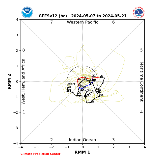
NOTE: First Euro MJO forecast Then GFS. And if you need a refresher or are unsure exactly what the MJO is click the link below.
https://www.njstrongweatherforum.com/t511-what-is-the-mjo-really
EURO


GFS


Now two things:
First this is only the trend Im pointing out here. In general the greater the amplitude the more influence the MJO can have on the atmosphere. The less amplitude equals less influence on the big picture potentially allowing other things to over-ride its effects. Less amplitude doesn't mean that it wont have an effect. It's always the sums of all the parts. For the recod the further away from the center of these graphs equals greater amplitude; the closer to the circle the less the amplitude. Inside the Circle equals null phase.
Second, over the past couple few weeks, the La Nina cold SSTA in the trop Pac have been very slowly beginning to warm POTENTIALLY hinting that the La Nina may actually be weakening. That said maybe if the MJO does comes out in phases 8-1-2 there may be a positive outcome regarding cold and snow chances, despite it being with very little amplitude, because the La Nina background state "may" be letting up a bit....at least with regards to the SSTA in the ENSO. But we need to be cautious with this. As I have stated in a prev. post there have been a couple of potential times since last winter that the Trop Pac has hinted at the possible weakening of the La Nina, but those attempts have been mere head fakes. Every time the SSTA begin to warm mother nature has said "nah...not yet."


Currently the SOI(https://www.longpaddock.qld.gov.au/soi/) continues to crank away in the upper teens and 20's. This tells me the atmosphere is not yet out of that Background Nina state. Is the subtle warming of the trop Pac so far this month compared to Dec and November another head fake or is this finally the true end to 3 consecutive mod La Nina's? Time will tell. As you can see below; however, Nino region 3.4 has taken another significant cold dip after seemingly on the rise.

Last edited by sroc4 on Sat Jan 07, 2023 6:43 pm; edited 3 times in total
_________________
"In weather and in life, there's no winning and losing; there's only winning and learning."
WINTER 2012/2013 TOTALS 43.65"WINTER 2017/2018 TOTALS 62.85" WINTER 2022/2023 TOTALS 4.9"
WINTER 2013/2014 TOTALS 64.85"WINTER 2018/2019 TOTALS 14.25" WINTER 2023/2024 TOTALS 13.1"
WINTER 2014/2015 TOTALS 71.20"WINTER 2019/2020 TOTALS 6.35"
WINTER 2015/2016 TOTALS 35.00"WINTER 2020/2021 TOTALS 37.75"
WINTER 2016/2017 TOTALS 42.25"WINTER 2021/2022 TOTALS 31.65"
sroc4- Admin
- Posts : 8331
Reputation : 301
Join date : 2013-01-07
Location : Wading River, LI
heehaw453 likes this post
Page 23 of 40 • 1 ... 13 ... 22, 23, 24 ... 31 ... 40 ![]()
|
|
|