
 Search
Long Range Thread 25.0
Page 24 of 40 •  1 ... 13 ... 23, 24, 25 ... 32 ... 40
 ![]()
Re: Long Range Thread 25.0
![]() by heehaw453 Sat Jan 07, 2023 3:32 pm
by heehaw453 Sat Jan 07, 2023 3:32 pm
https://cms.accuweather.com/wp-content/uploads/2023/01/SnowPotLtNxWkEastChan5Jan.jpg?w=632

heehaw453- Advanced Forecaster

- Posts : 3906
Join date : 2014-01-20
Re: Long Range Thread 25.0
![]() by sroc4 Sat Jan 07, 2023 4:20 pm
by sroc4 Sat Jan 07, 2023 4:20 pm
NOTE: First Euro MJO forecast Then GFS. And if you need a refresher or are unsure exactly what the MJO is click the link below.
https://www.njstrongweatherforum.com/t511-what-is-the-mjo-really
EURO


GFS


Now two things:
First this is only the trend Im pointing out here. In general the greater the amplitude the more influence the MJO can have on the atmosphere. The less amplitude equals less influence on the big picture potentially allowing other things to over-ride its effects. Less amplitude doesn't mean that it wont have an effect. It's always the sums of all the parts. For the recod the further away from the center of these graphs equals greater amplitude; the closer to the circle the less the amplitude. Inside the Circle equals null phase.
Second, over the past couple few weeks, the La Nina cold SSTA in the trop Pac have been very slowly beginning to warm POTENTIALLY hinting that the La Nina may actually be weakening. That said maybe if the MJO does comes out in phases 8-1-2 there may be a positive outcome regarding cold and snow chances, despite it being with very little amplitude, because the La Nina background state "may" be letting up a bit....at least with regards to the SSTA in the ENSO. But we need to be cautious with this. As I have stated in a prev. post there have been a couple of potential times since last winter that the Trop Pac has hinted at the possible weakening of the La Nina, but those attempts have been mere head fakes. Every time the SSTA begin to warm mother nature has said "nah...not yet."


Currently the SOI(https://www.longpaddock.qld.gov.au/soi/) continues to crank away in the upper teens and 20's. This tells me the atmosphere is not yet out of that Background Nina state. Is the subtle warming of the trop Pac so far this month compared to Dec and November another head fake or is this finally the true end to 3 consecutive mod La Nina's? Time will tell. As you can see below; however, Nino region 3.4 has taken another significant cold dip after seemingly on the rise.

Last edited by sroc4 on Sat Jan 07, 2023 6:43 pm; edited 3 times in total
sroc4- Admin

- Posts : 8331
Join date : 2013-01-07
heehaw453 likes this post
Re: Long Range Thread 25.0
![]() by sroc4 Sat Jan 07, 2023 4:23 pm
by sroc4 Sat Jan 07, 2023 4:23 pm


_________________
"In weather and in life, there's no winning and losing; there's only winning and learning."
WINTER 2012/2013 TOTALS 43.65"WINTER 2017/2018 TOTALS 62.85" WINTER 2022/2023 TOTALS 4.9"
WINTER 2013/2014 TOTALS 64.85"WINTER 2018/2019 TOTALS 14.25" WINTER 2023/2024 TOTALS 13.1"
WINTER 2014/2015 TOTALS 71.20"WINTER 2019/2020 TOTALS 6.35"
WINTER 2015/2016 TOTALS 35.00"WINTER 2020/2021 TOTALS 37.75"
WINTER 2016/2017 TOTALS 42.25"WINTER 2021/2022 TOTALS 31.65"

sroc4- Admin
- Posts : 8331
Reputation : 301
Join date : 2013-01-07
Location : Wading River, LI
Re: Long Range Thread 25.0
![]() by heehaw453 Sat Jan 07, 2023 5:29 pm
by heehaw453 Sat Jan 07, 2023 5:29 pm

heehaw453- Advanced Forecaster
- Posts : 3906
Reputation : 86
Join date : 2014-01-20
Location : Bedminster Township, PA Elevation 600' ASL
Re: Long Range Thread 25.0
![]() by amugs Sun Jan 08, 2023 10:33 pm
by amugs Sun Jan 08, 2023 10:33 pm
"If it walks like a duck, quacks like a duck, it's a duck." Models reversing & now showing a stretched #PolarVortex/wave reflection that brings colder weather to eastern North America. #MachineLearning model (has some timing issues) but has trended colder in East US for late Jan. pic.twitter.com/WMeVpJm6kv
— Judah Cohen (@judah47) January 8, 2023
_________________
Mugs
AKA:King: Snow Weenie
Self Proclaimed
WINTER 2014-15 : 55.12" +.02 for 6 coatings (avg. 35")
WINTER 2015-16 Total - 29.8" (Avg 35")
WINTER 2016-17 : 39.5" so far

amugs- Advanced Forecaster - Mod

- Posts : 15093
Reputation : 213
Join date : 2013-01-07
Age : 54
Location : Hillsdale,NJ
Re: Long Range Thread 25.0
![]() by sroc4 Mon Jan 09, 2023 5:57 am
by sroc4 Mon Jan 09, 2023 5:57 am
_________________
"In weather and in life, there's no winning and losing; there's only winning and learning."
WINTER 2012/2013 TOTALS 43.65"WINTER 2017/2018 TOTALS 62.85" WINTER 2022/2023 TOTALS 4.9"
WINTER 2013/2014 TOTALS 64.85"WINTER 2018/2019 TOTALS 14.25" WINTER 2023/2024 TOTALS 13.1"
WINTER 2014/2015 TOTALS 71.20"WINTER 2019/2020 TOTALS 6.35"
WINTER 2015/2016 TOTALS 35.00"WINTER 2020/2021 TOTALS 37.75"
WINTER 2016/2017 TOTALS 42.25"WINTER 2021/2022 TOTALS 31.65"
sroc4- Admin
- Posts : 8331
Reputation : 301
Join date : 2013-01-07
Location : Wading River, LI
Re: Long Range Thread 25.0
![]() by sroc4 Mon Jan 09, 2023 6:03 am
by sroc4 Mon Jan 09, 2023 6:03 am
sroc4 wrote:Euro added a little wrinkle for late week. Possibly two waves. First one torches but gets the front through, followed by a second wave that rounds base of the trough and rides the front. Almost like two storms from same trough. Not too worked up but something to watch I suppose.
First time seeing the SOI in single digits in quite some time. Id like to see it lower though for like 5days. Throw in a few negative numbers. That said perhaps a few more days in single digits could imply the atmosphere is easing up a little. Perhaps.
_________________
"In weather and in life, there's no winning and losing; there's only winning and learning."
WINTER 2012/2013 TOTALS 43.65"WINTER 2017/2018 TOTALS 62.85" WINTER 2022/2023 TOTALS 4.9"
WINTER 2013/2014 TOTALS 64.85"WINTER 2018/2019 TOTALS 14.25" WINTER 2023/2024 TOTALS 13.1"
WINTER 2014/2015 TOTALS 71.20"WINTER 2019/2020 TOTALS 6.35"
WINTER 2015/2016 TOTALS 35.00"WINTER 2020/2021 TOTALS 37.75"
WINTER 2016/2017 TOTALS 42.25"WINTER 2021/2022 TOTALS 31.65"
sroc4- Admin
- Posts : 8331
Reputation : 301
Join date : 2013-01-07
Location : Wading River, LI
MattyICE likes this post
Re: Long Range Thread 25.0
![]() by heehaw453 Mon Jan 09, 2023 7:03 am
by heehaw453 Mon Jan 09, 2023 7:03 am
Yep. That's been showing up as a possibility but I doubt it because the trough isn't a good negative tilt and there's not a 50/50 to slow things down. My thought is the energy slides off the coast similar to a frontal passage. Maybe some mood flakes though?sroc4 wrote:Euro added a little wrinkle for late week. Possibly two waves. First one torches but gets the front through, followed by a second wave that rounds base of the trough and rides the front. Almost like two storms from same trough. Not too worked up but something to watch I suppose.
heehaw453- Advanced Forecaster
- Posts : 3906
Reputation : 86
Join date : 2014-01-20
Location : Bedminster Township, PA Elevation 600' ASL
Re: Long Range Thread 25.0
![]() by sroc4 Mon Jan 09, 2023 8:13 am
by sroc4 Mon Jan 09, 2023 8:13 am
heehaw453 wrote:Yep. That's been showing up as a possibility but I doubt it because the trough isn't a good negative tilt and there's not a 50/50 to slow things down. My thought is the energy slides off the coast similar to a frontal passage. Maybe some mood flakes though?sroc4 wrote:Euro added a little wrinkle for late week. Possibly two waves. First one torches but gets the front through, followed by a second wave that rounds base of the trough and rides the front. Almost like two storms from same trough. Not too worked up but something to watch I suppose.
Don’t get me wrong simply going by how this winter has gone so far it’s hard to make any kind of argument that this will work. I certainly realize that. But I sticking with my theme from yesterday regarding optimism, when looking at this set up there are two things that seem different.
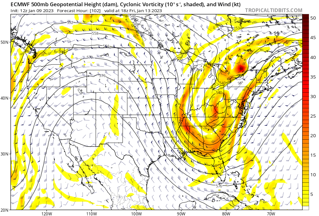
First if you run the 500mb vort maps back and forth on a look you see that on all three majore models the timing of the Pac energy behind our ridge seems to suggest amplification of our ridge as our first wave of LP passes well to the west. This gets the frontal boundary to the coast. Now exactly where we’ll still a bit of differences. Because the ridge is amplifying this will allow that second wave of energy to drop into the base to generate a second wave of LP along the boundary.

If you look at the EPS mslp maps you can see this take place between hrs 108 and 114. Literally a group of LP pops. There is still a large spread so take it with a grain of salt. But again if timing of ridge amplification and secondary LP along the boundary is right it’s possible.


The second thing I’m looking at that MAY indicate there could be a slight differ outcome is that SOI data. I mentioned above for the first time in a long time we have a single digit. If you look at the 500mb height anomaly maps of the Pacific Basin, over the next 5-7days there appears to be higher height anomalies showing up consistently in the area of Darwin Australia when compared to Tahiti. I have been monitoring this and the absolute SOI values all season and I can tell you there have been negatives over Darwin almost the entire season; certainly over the past month. This appears to be a significant change for this upcoming 5-7day time frame from the past month. If the 500mb anomaly maps are correct then the SOI value will persist in at least single digits if not lower which MAY affect how the atmosphere behaves down stream. It may mean nothing and we more likely than not still end up with oogatz out of this. But if you are looking at this set up from the optimistic side of the box, there are a couple of things to keep an eye on here. We are officially under 4-5.5 days from this event so it’s not like it’s long term. we’ll see. We track.
_________________
"In weather and in life, there's no winning and losing; there's only winning and learning."
WINTER 2012/2013 TOTALS 43.65"WINTER 2017/2018 TOTALS 62.85" WINTER 2022/2023 TOTALS 4.9"
WINTER 2013/2014 TOTALS 64.85"WINTER 2018/2019 TOTALS 14.25" WINTER 2023/2024 TOTALS 13.1"
WINTER 2014/2015 TOTALS 71.20"WINTER 2019/2020 TOTALS 6.35"
WINTER 2015/2016 TOTALS 35.00"WINTER 2020/2021 TOTALS 37.75"
WINTER 2016/2017 TOTALS 42.25"WINTER 2021/2022 TOTALS 31.65"
sroc4- Admin
- Posts : 8331
Reputation : 301
Join date : 2013-01-07
Location : Wading River, LI
heehaw453 and SENJsnowman like this post
Re: Long Range Thread 25.0
![]() by heehaw453 Mon Jan 09, 2023 8:57 am
by heehaw453 Mon Jan 09, 2023 8:57 am
heehaw453- Advanced Forecaster
- Posts : 3906
Reputation : 86
Join date : 2014-01-20
Location : Bedminster Township, PA Elevation 600' ASL
Re: Long Range Thread 25.0
![]() by MattyICE Mon Jan 09, 2023 9:55 am
by MattyICE Mon Jan 09, 2023 9:55 am
MattyICE- Advanced Forecaster
- Posts : 249
Reputation : 6
Join date : 2017-11-10
Age : 38
Location : Clifton, NJ (Eastern Passaic County)
Re: Long Range Thread 25.0
![]() by heehaw453 Mon Jan 09, 2023 10:08 am
by heehaw453 Mon Jan 09, 2023 10:08 am
Matty from my perspective I don't see anything in the 50/50 area to slow a developing storm down and I don't see a good leaning negatively tilted trough to throw good moisture back to the coast after the initial Low passes on by. If the ULL blew up more than that could tilt the trough more.MattyICE wrote:So would we want to see even more initial amplification on the front end to help slow the trough down a bit as it hits the coast? Allowing secondary energy to consolidate at the base? I feel like several models hint at this but most likely to far NE of us as the ridge rolls eastward as the next PAC storm knocks on the door.

heehaw453- Advanced Forecaster
- Posts : 3906
Reputation : 86
Join date : 2014-01-20
Location : Bedminster Township, PA Elevation 600' ASL
MattyICE likes this post
Re: Long Range Thread 25.0
![]() by Wheezer Mon Jan 09, 2023 10:09 am
by Wheezer Mon Jan 09, 2023 10:09 am
Wheezer- Posts : 30
Reputation : 6
Join date : 2017-11-08
Location : Cincinnati, Oh
sroc4 likes this post
Re: Long Range Thread 25.0
![]() by sroc4 Mon Jan 09, 2023 10:11 am
by sroc4 Mon Jan 09, 2023 10:11 am
MattyICE wrote:So would we want to see even more initial amplification on the front end to help slow the trough down a bit as it hits the coast? Allowing secondary energy to consolidate at the base? I feel like several models hint at this but most likely to far NE of us as the ridge rolls eastward as the next PAC storm knocks on the door.
Prob that and/or well timed ridge amplification which would allow the secondary wave to dig and amplify out ahead and the primary wave be there to prevent overamplification along the coast. Its interesting to to me to see how the Pac energy initially triggers the Ridge amplification out ahead, but once its hits the WC, and likely interacts across the Rockies triggering vertical turbulence do to the upsloping on the west side and down sloping on the east, which then triggers the collapse of the ridge. Again this doesn't seem to happen until the energy comes ashore west of the ridge. When the NE Atlantic is less than ideal, the timing of these things out west seems critical.
_________________
"In weather and in life, there's no winning and losing; there's only winning and learning."
WINTER 2012/2013 TOTALS 43.65"WINTER 2017/2018 TOTALS 62.85" WINTER 2022/2023 TOTALS 4.9"
WINTER 2013/2014 TOTALS 64.85"WINTER 2018/2019 TOTALS 14.25" WINTER 2023/2024 TOTALS 13.1"
WINTER 2014/2015 TOTALS 71.20"WINTER 2019/2020 TOTALS 6.35"
WINTER 2015/2016 TOTALS 35.00"WINTER 2020/2021 TOTALS 37.75"
WINTER 2016/2017 TOTALS 42.25"WINTER 2021/2022 TOTALS 31.65"
sroc4- Admin
- Posts : 8331
Reputation : 301
Join date : 2013-01-07
Location : Wading River, LI
MattyICE likes this post
Re: Long Range Thread 25.0
![]() by heehaw453 Mon Jan 09, 2023 11:51 am
by heehaw453 Mon Jan 09, 2023 11:51 am

heehaw453- Advanced Forecaster
- Posts : 3906
Reputation : 86
Join date : 2014-01-20
Location : Bedminster Township, PA Elevation 600' ASL
Re: Long Range Thread 25.0
![]() by sroc4 Mon Jan 09, 2023 1:39 pm
by sroc4 Mon Jan 09, 2023 1:39 pm
heehaw453 wrote:The Canadian model shows well what sroc was talking about. You get the ULL to close off at that latitude. That would blow up surface low pressure and slow it down. W/out a complete close off of the ULL I can't see something like this as the Atlantic flow is too progressive. I would want to see a more negatively tilted trough too.
Man Euro looks inviting. So close, so very close.....Damn you models. Why do you tease us so??????

_________________
"In weather and in life, there's no winning and losing; there's only winning and learning."
WINTER 2012/2013 TOTALS 43.65"WINTER 2017/2018 TOTALS 62.85" WINTER 2022/2023 TOTALS 4.9"
WINTER 2013/2014 TOTALS 64.85"WINTER 2018/2019 TOTALS 14.25" WINTER 2023/2024 TOTALS 13.1"
WINTER 2014/2015 TOTALS 71.20"WINTER 2019/2020 TOTALS 6.35"
WINTER 2015/2016 TOTALS 35.00"WINTER 2020/2021 TOTALS 37.75"
WINTER 2016/2017 TOTALS 42.25"WINTER 2021/2022 TOTALS 31.65"
sroc4- Admin
- Posts : 8331
Reputation : 301
Join date : 2013-01-07
Location : Wading River, LI
MattyICE likes this post
Re: Long Range Thread 25.0
![]() by amugs Mon Jan 09, 2023 1:43 pm
by amugs Mon Jan 09, 2023 1:43 pm
Interesting set up and have seen these trailing vorts blow up before after the front moves through. Timing and space are crucial to this. And you see a Banana High forming as well to help reinforce the cold air.
Brooklynwx from 33nrain map

_________________
Mugs
AKA:King: Snow Weenie
Self Proclaimed
WINTER 2014-15 : 55.12" +.02 for 6 coatings (avg. 35")
WINTER 2015-16 Total - 29.8" (Avg 35")
WINTER 2016-17 : 39.5" so far
amugs- Advanced Forecaster - Mod
- Posts : 15093
Reputation : 213
Join date : 2013-01-07
Age : 54
Location : Hillsdale,NJ
Re: Long Range Thread 25.0
![]() by heehaw453 Mon Jan 09, 2023 1:44 pm
by heehaw453 Mon Jan 09, 2023 1:44 pm
sroc4 wrote:heehaw453 wrote:The Canadian model shows well what sroc was talking about. You get the ULL to close off at that latitude. That would blow up surface low pressure and slow it down. W/out a complete close off of the ULL I can't see something like this as the Atlantic flow is too progressive. I would want to see a more negatively tilted trough too.
Man Euro looks inviting. So close, so very close.....Damn you models. Why do you tease us so??????
 Too much of emotional roll coaster Who am I kidding though
heehaw453- Advanced Forecaster
- Posts : 3906
Reputation : 86
Join date : 2014-01-20
Location : Bedminster Township, PA Elevation 600' ASL
sroc4 and SENJsnowman like this post
Re: Long Range Thread 25.0
![]() by heehaw453 Mon Jan 09, 2023 1:52 pm
by heehaw453 Mon Jan 09, 2023 1:52 pm

heehaw453- Advanced Forecaster
- Posts : 3906
Reputation : 86
Join date : 2014-01-20
Location : Bedminster Township, PA Elevation 600' ASL
sroc4 and MattyICE like this post
Re: Long Range Thread 25.0
![]() by docstox12 Mon Jan 09, 2023 2:57 pm
by docstox12 Mon Jan 09, 2023 2:57 pm
sroc4 wrote:heehaw453 wrote:The Canadian model shows well what sroc was talking about. You get the ULL to close off at that latitude. That would blow up surface low pressure and slow it down. W/out a complete close off of the ULL I can't see something like this as the Atlantic flow is too progressive. I would want to see a more negatively tilted trough too.
Man Euro looks inviting. So close, so very close.....Damn you models. Why do you tease us so??????

One of them has to be CP.

docstox12- Wx Statistician Guru

- Posts : 8504
Reputation : 222
Join date : 2013-01-07
Age : 73
Location : Monroe NY
CPcantmeasuresnow likes this post
Re: Long Range Thread 25.0
![]() by sroc4 Mon Jan 09, 2023 3:04 pm
by sroc4 Mon Jan 09, 2023 3:04 pm
docstox12 wrote:sroc4 wrote:heehaw453 wrote:The Canadian model shows well what sroc was talking about. You get the ULL to close off at that latitude. That would blow up surface low pressure and slow it down. W/out a complete close off of the ULL I can't see something like this as the Atlantic flow is too progressive. I would want to see a more negatively tilted trough too.
Man Euro looks inviting. So close, so very close.....Damn you models. Why do you tease us so??????
One of them has to be CP.
After crawling around the bushes and the weeds, fortunately undetected, over at OTI hearing some of the conversation over there I have no doubt Doc....no Doubt. LOL. But shhhhhh. Please don't tell him I was over there hiding out in the bushes. I would like to stop by again and perhaps say hello and have a coconut cocktail. Hopefully he's not too mad at me and my perpetual optimism. I cant help it. It is my minds way of dealing with the "madness of my misery" from lack of cold and snow.
_________________
"In weather and in life, there's no winning and losing; there's only winning and learning."
WINTER 2012/2013 TOTALS 43.65"WINTER 2017/2018 TOTALS 62.85" WINTER 2022/2023 TOTALS 4.9"
WINTER 2013/2014 TOTALS 64.85"WINTER 2018/2019 TOTALS 14.25" WINTER 2023/2024 TOTALS 13.1"
WINTER 2014/2015 TOTALS 71.20"WINTER 2019/2020 TOTALS 6.35"
WINTER 2015/2016 TOTALS 35.00"WINTER 2020/2021 TOTALS 37.75"
WINTER 2016/2017 TOTALS 42.25"WINTER 2021/2022 TOTALS 31.65"
sroc4- Admin
- Posts : 8331
Reputation : 301
Join date : 2013-01-07
Location : Wading River, LI
CPcantmeasuresnow likes this post
Re: Long Range Thread 25.0
![]() by heehaw453 Mon Jan 09, 2023 3:23 pm
by heehaw453 Mon Jan 09, 2023 3:23 pm

heehaw453- Advanced Forecaster
- Posts : 3906
Reputation : 86
Join date : 2014-01-20
Location : Bedminster Township, PA Elevation 600' ASL
Re: Long Range Thread 25.0
![]() by heehaw453 Mon Jan 09, 2023 5:14 pm
by heehaw453 Mon Jan 09, 2023 5:14 pm


heehaw453- Advanced Forecaster
- Posts : 3906
Reputation : 86
Join date : 2014-01-20
Location : Bedminster Township, PA Elevation 600' ASL
sroc4 and MattyICE like this post
Re: Long Range Thread 25.0
![]() by sroc4 Mon Jan 09, 2023 5:41 pm
by sroc4 Mon Jan 09, 2023 5:41 pm
heehaw453 wrote:GFS ULL disorganized and doesn't close off. GFS scenario the energy just gets pushed out to sea. Note the difference between Euro top and GFS bottom. Euro has a slightly better ridge and less trough interference to the west that probably makes the difference. I think next 24-36 hours the sh#t either real or it's not. I say no until I see more consensus as that damn PAC flow is a thorn in rear.
Also notice the trough is a bit faster to hit the west coast on the GFS compared to the Euro. The trough on the EC is open and positive tilted. Oogatz if that's the result for sure. I will say over the years the GFS's bias has been that's its a progressive model FWIW. I agree there is no way Im jumping the gun on this one. Tamping down our ridge at inopportune times has been a major Achilles heal all winter, so until I see it play out otherwise that's my expectation...for now...too. Most of the southern energy comes on shore tomorrow so 12z tomorrow and def 00z over night Tuesday should have solid data input.
_________________
"In weather and in life, there's no winning and losing; there's only winning and learning."
WINTER 2012/2013 TOTALS 43.65"WINTER 2017/2018 TOTALS 62.85" WINTER 2022/2023 TOTALS 4.9"
WINTER 2013/2014 TOTALS 64.85"WINTER 2018/2019 TOTALS 14.25" WINTER 2023/2024 TOTALS 13.1"
WINTER 2014/2015 TOTALS 71.20"WINTER 2019/2020 TOTALS 6.35"
WINTER 2015/2016 TOTALS 35.00"WINTER 2020/2021 TOTALS 37.75"
WINTER 2016/2017 TOTALS 42.25"WINTER 2021/2022 TOTALS 31.65"
sroc4- Admin
- Posts : 8331
Reputation : 301
Join date : 2013-01-07
Location : Wading River, LI
heehaw453 and MattyICE like this post
Re: Long Range Thread 25.0
![]() by heehaw453 Mon Jan 09, 2023 5:46 pm
by heehaw453 Mon Jan 09, 2023 5:46 pm


heehaw453- Advanced Forecaster
- Posts : 3906
Reputation : 86
Join date : 2014-01-20
Location : Bedminster Township, PA Elevation 600' ASL
Re: Long Range Thread 25.0
![]() by Frank_Wx Mon Jan 09, 2023 7:49 pm
by Frank_Wx Mon Jan 09, 2023 7:49 pm
_________________
_______________________________________________________________________________________________________
CLICK HERE to view NJ Strong Snowstorm Classifications

Frank_Wx- Godzilla Seeker
- Posts : 21305
Reputation : 328
Join date : 2013-01-05
Age : 31
Location : Jersey City, NJ -

Re: Long Range Thread 25.0
![]() by jmanley32 Mon Jan 09, 2023 8:29 pm
by jmanley32 Mon Jan 09, 2023 8:29 pm
Duh the tweeker right up front lol, just playing CP, but from how upset you get it's the first one that hit me lmao.docstox12 wrote:sroc4 wrote:heehaw453 wrote:The Canadian model shows well what sroc was talking about. You get the ULL to close off at that latitude. That would blow up surface low pressure and slow it down. W/out a complete close off of the ULL I can't see something like this as the Atlantic flow is too progressive. I would want to see a more negatively tilted trough too.
Man Euro looks inviting. So close, so very close.....Damn you models. Why do you tease us so??????
One of them has to be CP.

jmanley32- Senior Enthusiast

- Posts : 20516
Reputation : 108
Join date : 2013-12-12
Age : 42
Location : Yonkers, NY
CPcantmeasuresnow likes this post
Page 24 of 40 • 1 ... 13 ... 23, 24, 25 ... 32 ... 40 ![]()
|
|
|