
 Search
Long Range Thread 25.0
Page 4 of 40 •  1, 2, 3, 4, 5 ... 22 ... 40
 ![]()
Re: Long Range Thread 25.0
![]() by heehaw453 Tue Nov 22, 2022 11:52 am
by heehaw453 Tue Nov 22, 2022 11:52 am
So my thought is NW of I95 have some chances, albeit modest ones in beginning of December and the coast will probably need to wait for the PNA to allow deeper cold air into the area. Maybe on/after 12/10 for coast. If we can get NAO blocking to assert itself and just a bit of cooperation from the PNA then we'll have an active December for tracking. December snows have been rather elusive for the most part especially along the coast for past several years, so it'd be nice change of fortunes.

heehaw453- Advanced Forecaster

- Posts : 3907
Join date : 2014-01-20
Re: Long Range Thread 25.0
![]() by sroc4 Tue Nov 22, 2022 4:09 pm
by sroc4 Tue Nov 22, 2022 4:09 pm
heehaw453 wrote:Going out about 10 days on the EPS. That's about my limit for ensembles h5 analysis. Kind of like what Mugs has been showing. This projected pattern is zonal and with NAO blocking storms tend to slide underneath the area. However, as long as the PNA stays a bit negative you won't get big amplified storms most likely and not arctic express to drive cold air in right to the coast.
So my thought is NW of I95 have some chances, albeit modest ones in beginning of December and the coast will probably need to wait for the PNA to allow deeper cold air into the area. Maybe on/after 12/10 for coast. If we can get NAO blocking to assert itself and just a bit of cooperation from the PNA then we'll have an active December for tracking. December snows have been rather elusive for the most part especially along the coast for past several years, so it'd be nice change of fortunes.
I cant say I disagree at all with the ideas between now and Dec 5th-7th. That said after that time frame, reading between the tea leaves as we head out beyond the 5th or so, is really encouraging IMHO; setting the stage for a cold temp anomaly regime for a decent amount of time in the eastern half of the CONUS. Its starting to show itself in the means. This End of run EPS is drool worthy with a neg EPO and neg NAO on the table here pushing the trop PV around the Hudson Bay. This exactly where you want that gyre spinning sending pieces of polar energy south to play with energy coming out of the SW sub trop and or Pac jet. GEFS similar. That said its all at the very end of the time frame so Im tempering all expectations at this time frame. But again reading the tea leaves(STAT forecasts and Trop forcing's) its encouraging none the less. Regarding the thoughts on the -PNA I would have to agree thata -EPO alone often times isnt enough to set the stage for the coastal plain as this tends to favor amplification of energy too far west which amplifies the WAR out ahead. That said IF and thats a big IF we can get that NAO to cooperate it offers the necessary resistance to push back with cold air over the NE. For now we sit back and enjoy the Thanksgiving holiday and hope the GMEN!! can beat the Cowgirls Thursday.
sroc4- Admin

- Posts : 8441
Join date : 2013-01-07
Re: Long Range Thread 25.0
![]() by amugs Tue Nov 22, 2022 9:45 pm
by amugs Tue Nov 22, 2022 9:45 pm
heehaw453 wrote:Going out about 10 days on the EPS. That's about my limit for ensembles h5 analysis. Kind of like what Mugs has been showing. This projected pattern is zonal and with NAO blocking storms tend to slide underneath the area. However, as long as the PNA stays a bit negative you won't get big amplified storms most likely and not arctic express to drive cold air in right to the coast.
So my thought is NW of I95 have some chances, albeit modest ones in beginning of December and the coast will probably need to wait for the PNA to allow deeper cold air into the area. Maybe on/after 12/10 for coast. If we can get NAO blocking to assert itself and just a bit of cooperation from the PNA then we'll have an active December for tracking. December snows have been rather elusive for the most part especially along the coast for past several years, so it'd be nice change of fortunes.
The SE ridge will be transient and get pushed back by that epo and nao build. Response in Phase 7 is not for a SE ridge. Also, the pna ridge will get eroded by that deep N in the Aleutian GOA region.
The PNA we can work with, above 40N I think you can get wintry mix events, not true deep arctic but then again you don't need that for every storm.
Cautiously optimistic for early Dec. And beyond. Dec 5th time frame always seems to have some mischief around it for a storm in the good analog winters. We'll see.
_________________
Mugs
AKA:King: Snow Weenie
Self Proclaimed
WINTER 2014-15 : 55.12" +.02 for 6 coatings (avg. 35")
WINTER 2015-16 Total - 29.8" (Avg 35")
WINTER 2016-17 : 39.5" so far

amugs- Advanced Forecaster - Mod

- Posts : 15130
Reputation : 213
Join date : 2013-01-07
Age : 54
Location : Hillsdale,NJ
Re: Long Range Thread 25.0
![]() by dkodgis Tue Nov 22, 2022 10:00 pm
by dkodgis Tue Nov 22, 2022 10:00 pm
(* Doc, remember eating that candy and watching this?
https://www.youtube.com/watch?v=ExSlyoVTX3I

dkodgis- Senior Enthusiast

- Posts : 2661
Reputation : 98
Join date : 2013-12-29
Re: Long Range Thread 25.0
![]() by Irish Tue Nov 22, 2022 10:02 pm
by Irish Tue Nov 22, 2022 10:02 pm
sroc4 wrote:heehaw453 wrote:Going out about 10 days on the EPS. That's about my limit for ensembles h5 analysis. Kind of like what Mugs has been showing. This projected pattern is zonal and with NAO blocking storms tend to slide underneath the area. However, as long as the PNA stays a bit negative you won't get big amplified storms most likely and not arctic express to drive cold air in right to the coast.
So my thought is NW of I95 have some chances, albeit modest ones in beginning of December and the coast will probably need to wait for the PNA to allow deeper cold air into the area. Maybe on/after 12/10 for coast. If we can get NAO blocking to assert itself and just a bit of cooperation from the PNA then we'll have an active December for tracking. December snows have been rather elusive for the most part especially along the coast for past several years, so it'd be nice change of fortunes.
I cant say I disagree at all with the ideas between now and Dec 5th-7th. That said after that time frame, reading between the tea leaves as we head out beyond the 5th or so, is really encouraging IMHO; setting the stage for a cold temp anomaly regime for a decent amount of time in the eastern half of the CONUS. Its starting to show itself in the means. This End of run EPS is drool worthy with a neg EPO and neg NAO on the table here pushing the trop PV around the Hudson Bay. This exactly where you want that gyre spinning sending pieces of polar energy south to play with energy coming out of the SW sub trop and or Pac jet. GEFS similar. That said its all at the very end of the time frame so Im tempering all expectations at this time frame. But again reading the tea leaves(STAT forecasts and Trop forcing's) its encouraging none the less. Regarding the thoughts on the -PNA I would have to agree thata -EPO alone often times isnt enough to set the stage for the coastal plain as this tends to favor amplification of energy too far west which amplifies the WAR out ahead. That said IF and thats a big IF we can get that NAO to cooperate it offers the necessary resistance to push back with cold air over the NE. For now we sit back and enjoy the Thanksgiving holiday and hope the GMEN!! can beat the Cowgirls Thursday.
See, you had me at hello...I mean until the bolded garbage about the pretenders beating the Boys. First of all, that ain't happening, Dallas is a way better team and the point spread is showing it. Secondly, Dallas is getting some home cooking, "Giant" Turkey being served up on the Star!

Irish- Pro Enthusiast

- Posts : 788
Reputation : 19
Join date : 2019-01-16
Age : 46
Location : Old Bridge, NJ
Re: Long Range Thread 25.0
![]() by docstox12 Wed Nov 23, 2022 6:04 am
by docstox12 Wed Nov 23, 2022 6:04 am
dkodgis wrote:Isn’t it that here lately it has not been cold enough to snow much in Dec with good ‘n plenty* cold coming ‘round in January. However I do remember some Decembers here in the last 23 years that made me a believer. I thought 2-3 December storms was an obligatory thing for the Hudson Valley
(* Doc, remember eating that candy and watching this?
https://www.youtube.com/watch?v=ExSlyoVTX3I
I only have 20 years of Hudson Valley observations of Decembers, but back in Bergen County from 1960 on, Decembers are not usually big snow producers like Jan and Feb are.More like March.However, when one does come in December, they are epic, Dec 11-12 1960 and Boxing Day Blizzard of 2010.
Yep, remember that "choo choo Charlie" ad very well.My dentist must have put his kid through college the cavities that stuff gave me.Wonderful stuff,refined sugar and chemicals,LOL.
Let's hope the long range can give us a White Christmas up here anyway.

docstox12- Wx Statistician Guru

- Posts : 8589
Reputation : 222
Join date : 2013-01-07
Age : 73
Location : Monroe NY
Re: Long Range Thread 25.0
![]() by amugs Wed Nov 23, 2022 6:50 pm
by amugs Wed Nov 23, 2022 6:50 pm

_________________
Mugs
AKA:King: Snow Weenie
Self Proclaimed
WINTER 2014-15 : 55.12" +.02 for 6 coatings (avg. 35")
WINTER 2015-16 Total - 29.8" (Avg 35")
WINTER 2016-17 : 39.5" so far
amugs- Advanced Forecaster - Mod
- Posts : 15130
Reputation : 213
Join date : 2013-01-07
Age : 54
Location : Hillsdale,NJ
Re: Long Range Thread 25.0
![]() by sroc4 Thu Nov 24, 2022 8:15 am
by sroc4 Thu Nov 24, 2022 8:15 am
Irish wrote:sroc4 wrote:heehaw453 wrote:Going out about 10 days on the EPS. That's about my limit for ensembles h5 analysis. Kind of like what Mugs has been showing. This projected pattern is zonal and with NAO blocking storms tend to slide underneath the area. However, as long as the PNA stays a bit negative you won't get big amplified storms most likely and not arctic express to drive cold air in right to the coast.
So my thought is NW of I95 have some chances, albeit modest ones in beginning of December and the coast will probably need to wait for the PNA to allow deeper cold air into the area. Maybe on/after 12/10 for coast. If we can get NAO blocking to assert itself and just a bit of cooperation from the PNA then we'll have an active December for tracking. December snows have been rather elusive for the most part especially along the coast for past several years, so it'd be nice change of fortunes.
I cant say I disagree at all with the ideas between now and Dec 5th-7th. That said after that time frame, reading between the tea leaves as we head out beyond the 5th or so, is really encouraging IMHO; setting the stage for a cold temp anomaly regime for a decent amount of time in the eastern half of the CONUS. Its starting to show itself in the means. This End of run EPS is drool worthy with a neg EPO and neg NAO on the table here pushing the trop PV around the Hudson Bay. This exactly where you want that gyre spinning sending pieces of polar energy south to play with energy coming out of the SW sub trop and or Pac jet. GEFS similar. That said its all at the very end of the time frame so Im tempering all expectations at this time frame. But again reading the tea leaves(STAT forecasts and Trop forcing's) its encouraging none the less. Regarding the thoughts on the -PNA I would have to agree thata -EPO alone often times isnt enough to set the stage for the coastal plain as this tends to favor amplification of energy too far west which amplifies the WAR out ahead. That said IF and thats a big IF we can get that NAO to cooperate it offers the necessary resistance to push back with cold air over the NE. For now we sit back and enjoy the Thanksgiving holiday and hope the GMEN!! can beat the Cowgirls Thursday.
See, you had me at hello...I mean until the bolded garbage about the pretenders beating the Boys. First of all, that ain't happening, Dallas is a way better team and the point spread is showing it. Secondly, Dallas is getting some home cooking, "Giant" Turkey being served up on the Star!
Lol Irish. I love the chirps. But that’s what I’d expect from a Cowgirls fan whose team is built to be a decent regular season team but choke in the playoffs. That’s really got to be horrible to have those expectations each year only to be let down year after year. To be honest I’m not sure how you haven’t jumped ship yet. First Tony Romo, and now Dak a combined playoff record of 3-8. Pretty sad if you ask me.
Now the GMEN. Pretenders? No. Overachievers? Ahead of schedule? Perhaps. But you can clearly see there is a shift taking place in the NFC East. The Cowgirls time is fading my friend. Fading fast.
All chirps aside wishing you and everyone else on the board a very Happy Thanks giving. Enjoy the time with family and friends.
I Moved this over to the banter so if anyone wishes to cont the chirps we dont clog up the LR thread. Here is an image of the latest EPS valid for 12z Dec 7th. Blocking conts to trend stronger, esp in the NAO region.
_________________
"In weather and in life, there's no winning and losing; there's only winning and learning."
WINTER 2012/2013 TOTALS 43.65"WINTER 2017/2018 TOTALS 62.85" WINTER 2022/2023 TOTALS 4.9"
WINTER 2013/2014 TOTALS 64.85"WINTER 2018/2019 TOTALS 14.25" WINTER 2023/2024 TOTALS 13.1"
WINTER 2014/2015 TOTALS 71.20"WINTER 2019/2020 TOTALS 6.35"
WINTER 2015/2016 TOTALS 35.00"WINTER 2020/2021 TOTALS 37.75"
WINTER 2016/2017 TOTALS 42.25"WINTER 2021/2022 TOTALS 31.65"

sroc4- Admin
- Posts : 8441
Reputation : 302
Join date : 2013-01-07
Location : Wading River, LI
Re: Long Range Thread 25.0
![]() by heehaw453 Fri Nov 25, 2022 9:37 am
by heehaw453 Fri Nov 25, 2022 9:37 am
heehaw453- Advanced Forecaster
- Posts : 3907
Reputation : 86
Join date : 2014-01-20
Location : Bedminster Township, PA Elevation 600' ASL
Re: Long Range Thread 25.0
![]() by amugs Fri Nov 25, 2022 6:02 pm
by amugs Fri Nov 25, 2022 6:02 pm
heehaw453 wrote:No change to my thoughts on when we start seeing chances. Based on 10 day ensembles I think we have to deal with an Atlantic ridge that eventually will get smoothed out by an -NAO and trough that gets kicked past PNA domain. IMO that process is going to take a bit of time and will see things pushed back a bit on guidance. That being said NW of I95 very modest chances before 12/10. I wouldn't at all be surprised for this pattern to take mid December to start yielding interesting tracking, but if it does evolve with favorable NAO and more cooperative PAC it will include coastal areas in prime threat targets. We wait IMO.
Haw I woudl oevall agree but I see the pattern evolving a bit quicker as we enter the 1st week of December. The SCAN/Urals ridge and +EAMT will perform a one t1o punch over the arctic with a Siberian High as well. This will put pressure on the PV. This heat ransfer flux should start to pick up as we head into Dec. Now how will that lay out is anyone's guess at this stage BUT if we have a predecccor event like we did in Oct and Nov then things would get very interesting and like you said about mid month. The models are picking up on the pattern evolution and we can start to see the EPS adn GEFS aiming for next weekend to see the gears get going in motion.
GEFS on Dec 5th

Ridge Bridge sets up over the arctic

EPS in 10 days is on the $$ for Haws call ....Dec 10th

So we keep an eye on tehprogression - GEFS sometimes are too fast with the flip BUT it may not be when you have the EPO and nAO both going negative before this.
EPO
That is your split - IF so it would be a fantastic location for us here. Could get real and fast.
_________________
Mugs
AKA:King: Snow Weenie
Self Proclaimed
WINTER 2014-15 : 55.12" +.02 for 6 coatings (avg. 35")
WINTER 2015-16 Total - 29.8" (Avg 35")
WINTER 2016-17 : 39.5" so far
amugs- Advanced Forecaster - Mod
- Posts : 15130
Reputation : 213
Join date : 2013-01-07
Age : 54
Location : Hillsdale,NJ
heehaw453 likes this post
Re: Long Range Thread 25.0
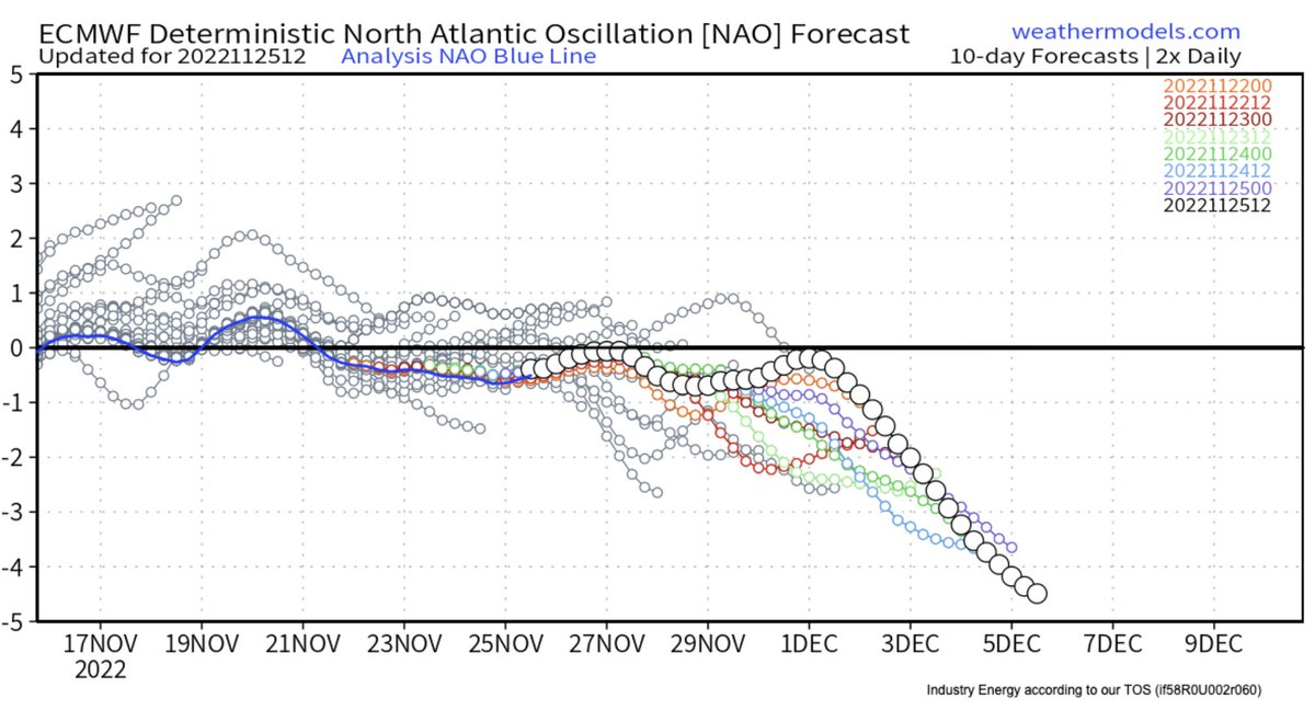
![]() by heehaw453 Sat Nov 26, 2022 8:12 am
by heehaw453 Sat Nov 26, 2022 8:12 am
This is a strong signal for NAO blocking on EPS with good agreement on timing and location with the GEFS. Coupled with cross polar flow via the -EPO. When you start to light up the arctic with "reds" like this good things more often than not occur in the EC with regard to winter weather. Definitely encouraging.

heehaw453- Advanced Forecaster
- Posts : 3907
Reputation : 86
Join date : 2014-01-20
Location : Bedminster Township, PA Elevation 600' ASL
mmanisca and SENJsnowman like this post
Re: Long Range Thread 25.0
![]() by amugs Sat Nov 26, 2022 10:23 am
by amugs Sat Nov 26, 2022 10:23 am

_________________
Mugs
AKA:King: Snow Weenie
Self Proclaimed
WINTER 2014-15 : 55.12" +.02 for 6 coatings (avg. 35")
WINTER 2015-16 Total - 29.8" (Avg 35")
WINTER 2016-17 : 39.5" so far
amugs- Advanced Forecaster - Mod
- Posts : 15130
Reputation : 213
Join date : 2013-01-07
Age : 54
Location : Hillsdale,NJ
SENJsnowman likes this post
Re: Long Range Thread 25.0
![]() by amugs Sat Nov 26, 2022 4:38 pm
by amugs Sat Nov 26, 2022 4:38 pm
If it comes about then....WATCH OUT!!!

_________________
Mugs
AKA:King: Snow Weenie
Self Proclaimed
WINTER 2014-15 : 55.12" +.02 for 6 coatings (avg. 35")
WINTER 2015-16 Total - 29.8" (Avg 35")
WINTER 2016-17 : 39.5" so far
amugs- Advanced Forecaster - Mod
- Posts : 15130
Reputation : 213
Join date : 2013-01-07
Age : 54
Location : Hillsdale,NJ
weatherwatchermom likes this post
Re: Long Range Thread 25.0
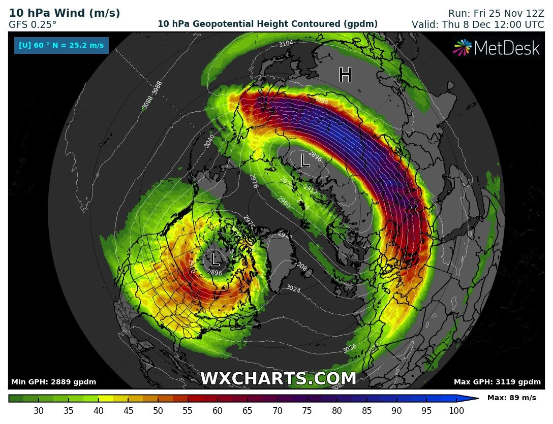
![]() by amugs Sun Nov 27, 2022 3:47 pm
by amugs Sun Nov 27, 2022 3:47 pm

_________________
Mugs
AKA:King: Snow Weenie
Self Proclaimed
WINTER 2014-15 : 55.12" +.02 for 6 coatings (avg. 35")
WINTER 2015-16 Total - 29.8" (Avg 35")
WINTER 2016-17 : 39.5" so far
amugs- Advanced Forecaster - Mod
- Posts : 15130
Reputation : 213
Join date : 2013-01-07
Age : 54
Location : Hillsdale,NJ
heehaw453 and weatherwatchermom like this post
Re: Long Range Thread 25.0
![]() by sroc4 Sun Nov 27, 2022 4:33 pm
by sroc4 Sun Nov 27, 2022 4:33 pm
amugs wrote:Can you say MADONNE!! This Greenbland block is absurd, Sandy reminiscent.
But if that negative PNA persists it might not make a difference. Will still keep the storm track less than ideal; esp for the coastal plain. That negative PNA can be a real bitch.
Last winter we had a similar set up that disappointed.
_________________
"In weather and in life, there's no winning and losing; there's only winning and learning."
WINTER 2012/2013 TOTALS 43.65"WINTER 2017/2018 TOTALS 62.85" WINTER 2022/2023 TOTALS 4.9"
WINTER 2013/2014 TOTALS 64.85"WINTER 2018/2019 TOTALS 14.25" WINTER 2023/2024 TOTALS 13.1"
WINTER 2014/2015 TOTALS 71.20"WINTER 2019/2020 TOTALS 6.35"
WINTER 2015/2016 TOTALS 35.00"WINTER 2020/2021 TOTALS 37.75"
WINTER 2016/2017 TOTALS 42.25"WINTER 2021/2022 TOTALS 31.65"
sroc4- Admin
- Posts : 8441
Reputation : 302
Join date : 2013-01-07
Location : Wading River, LI
Re: Long Range Thread 25.0
![]() by heehaw453 Sun Nov 27, 2022 4:34 pm
by heehaw453 Sun Nov 27, 2022 4:34 pm
Major signal for intense blocking that retrogrades right into Labrador Canada. I think the temps will respond in kind once SE ridge is pushed back. The RNA is workable as it's not extreme like last year and would allow for energy to slide across the country. And then you back up the flow which then all bets are off. Again I like somewhere post 10th with this situation for some interesting model guidance for the area. Also, the usual caveats apply in that your backyard may not score big here as with any pattern there are no guarantees, but someone on the east coast (DC-BOS) will most likely have a major snowstorm before Christmas IMO. There is no reason for me to doubt z500 guidance ATTM and this is looking like stubborn big dog pattern. I'm onboard the potential train...amugs wrote:Can you say MADONNE!! This Greenbland block is absurd, Sandy reminiscent.
heehaw453- Advanced Forecaster
- Posts : 3907
Reputation : 86
Join date : 2014-01-20
Location : Bedminster Township, PA Elevation 600' ASL
Re: Long Range Thread 25.0
![]() by amugs Sun Nov 27, 2022 9:22 pm
by amugs Sun Nov 27, 2022 9:22 pm
_________________
Mugs
AKA:King: Snow Weenie
Self Proclaimed
WINTER 2014-15 : 55.12" +.02 for 6 coatings (avg. 35")
WINTER 2015-16 Total - 29.8" (Avg 35")
WINTER 2016-17 : 39.5" so far
amugs- Advanced Forecaster - Mod
- Posts : 15130
Reputation : 213
Join date : 2013-01-07
Age : 54
Location : Hillsdale,NJ
Re: Long Range Thread 25.0
![]() by amugs Mon Nov 28, 2022 9:48 am
by amugs Mon Nov 28, 2022 9:48 am
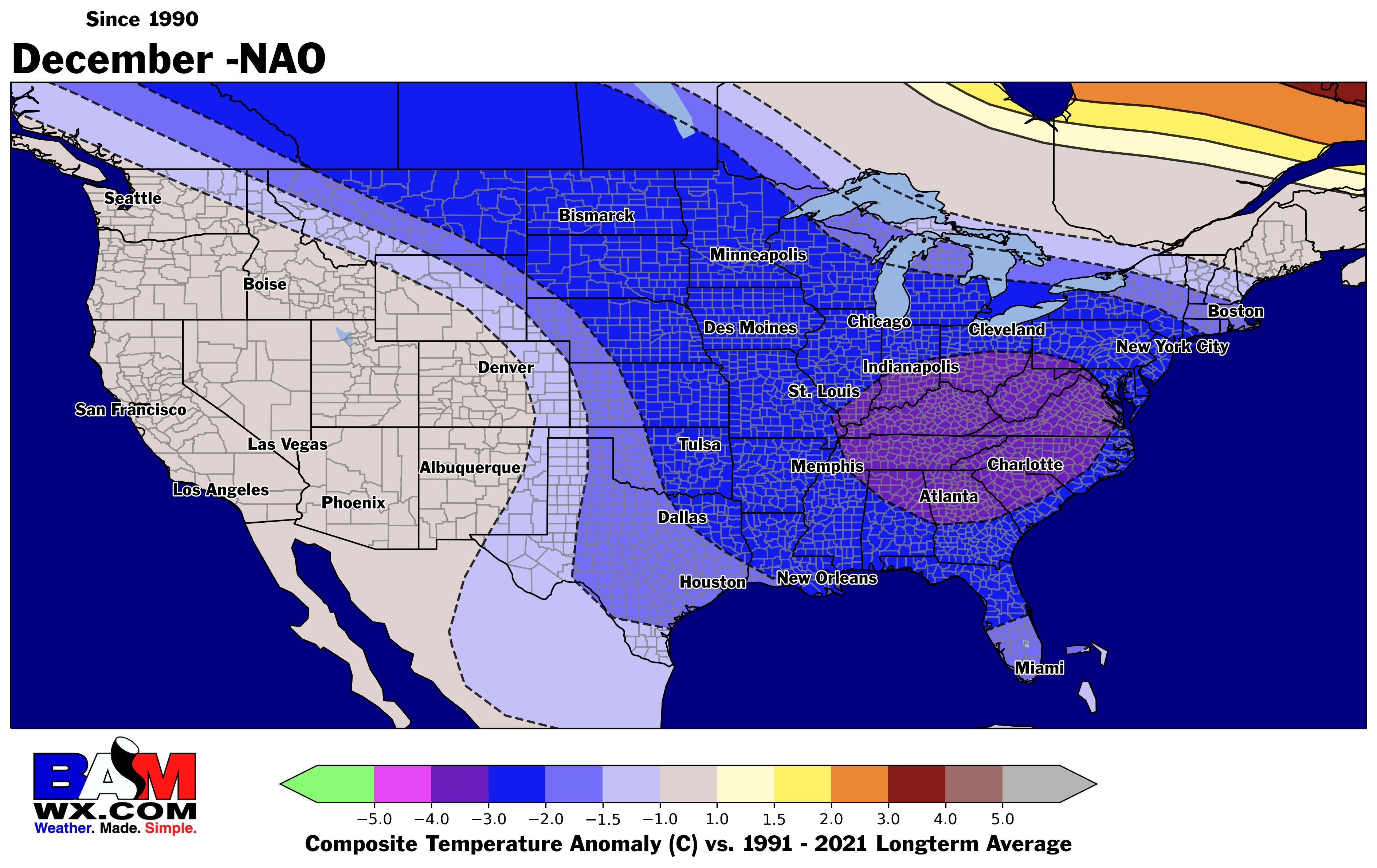
Interesting Map and temperature correlatoin to the Negative NAO
_________________
Mugs
AKA:King: Snow Weenie
Self Proclaimed
WINTER 2014-15 : 55.12" +.02 for 6 coatings (avg. 35")
WINTER 2015-16 Total - 29.8" (Avg 35")
WINTER 2016-17 : 39.5" so far
amugs- Advanced Forecaster - Mod
- Posts : 15130
Reputation : 213
Join date : 2013-01-07
Age : 54
Location : Hillsdale,NJ
Re: Long Range Thread 25.0
![]() by amugs Mon Nov 28, 2022 9:51 am
by amugs Mon Nov 28, 2022 9:51 am
_________________
Mugs
AKA:King: Snow Weenie
Self Proclaimed
WINTER 2014-15 : 55.12" +.02 for 6 coatings (avg. 35")
WINTER 2015-16 Total - 29.8" (Avg 35")
WINTER 2016-17 : 39.5" so far
amugs- Advanced Forecaster - Mod
- Posts : 15130
Reputation : 213
Join date : 2013-01-07
Age : 54
Location : Hillsdale,NJ
heehaw453 likes this post
Re: Long Range Thread 25.0
![]() by amugs Mon Nov 28, 2022 10:22 am
by amugs Mon Nov 28, 2022 10:22 am

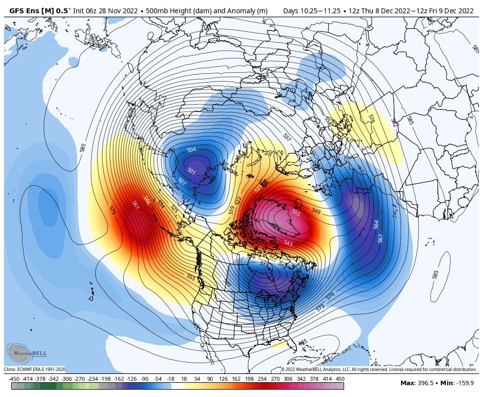
If you can look past the 0z Nov 28 model runs, you will see that abundant winter temperature and weather threats still exist in North America.
Those NWP depictions that came in last night seemed to be corrupted, mostly because none of the versions a) had properly initialized observational data, and b) had no idea on how to handle the extreme high-latitude blocking anomaly that is taking shape over Greenland. The 6z GFS suite seemed a little better, particularly the ensemble platform, and was faithful to the idea that a broad base of Arctic air across northern and western Canada will overtake most of the lower 48 states.
You should still be confident about cold weather potential going forward. The transient cold air mass and frontal structure now entering the High Plains is not a big deal, but will trim back outrageous warm-weather expectations in the southern and eastern tiers of the U.S. in the near term. Look at the storm couplet by the International Dateline, acting in concert to advect warm air into the Arctic Circle (a similar feature in the Atlantic Basin is performing the same function west of Scandinavia). When it gets warmer closer to the North Pole, lower latitudes will be colder. And if the warmth "up north" is strong, the set-up stays awhile, the cold pools in Canada and the U.S. perpetuate until some other disturbance comes into the Yukon and Northwest Territories to tear the ridge down.
Also note the well-defined southern branch flow through Mexico. This is a natural path of least resistance for disturbance coming into California (or the Baja CA region) and in the process pulls colder air further south. There are sizable precipitation threats upcoming in the longer term, and that might mean the snow and ice line gets dragged down into the lower Great Plains and Ohio River watershed as well.
One last concern is that this is an ideal set-up for a James Bay (cAk) vortex. Besides smashing down the subtropical high to its south, the presence of -AO/-NAO blocking aloft might introduce the coldest weather to the Midwest, Great Lakes and Northeast by the second week of December (MISO, PJM, NYMEX, NEISO). If you want warmth, Florida and the Desert Southwest should be OK.
_________________
Mugs
AKA:King: Snow Weenie
Self Proclaimed
WINTER 2014-15 : 55.12" +.02 for 6 coatings (avg. 35")
WINTER 2015-16 Total - 29.8" (Avg 35")
WINTER 2016-17 : 39.5" so far
amugs- Advanced Forecaster - Mod
- Posts : 15130
Reputation : 213
Join date : 2013-01-07
Age : 54
Location : Hillsdale,NJ
Re: Long Range Thread 25.0
![]() by amugs Mon Nov 28, 2022 10:35 am
by amugs Mon Nov 28, 2022 10:35 am
The Stratospheric water vapor injected by the eruption of the Hunga-Tonga Hunga Volcano in Dec 2021 has now made it past 45N. I continue to monitor this as part of ongoing research related to how this anomalously high H2O concentration might impact the #PolarVortex #wxtwitter pic.twitter.com/gQVdDmFmG6
— Mark Margavage (@MeteoMark) November 28, 2022
This is moving quite quickly as it was at 20N (Florida the end of August) so it moved 25 degrees lattitude in 2.5 months. By end of December we should be up at the 55 degree lattitudewith this Wv in the atmosphere which is :

This could promote more cold outbreaks and this encircles the globe with its heavy concnertration of water vapor WV which is massive amounts of hear and moisture. As I put in banter that Damien remarked on quite hilariously the amount in gallons is astronomical - rivaling the great flood of Noah's Ark (?) - maybe Doc reemebre this LOL! Also, disrupting the jet structure even further in more of a wavy response to all this is part of the equation. As the warmth rises into the atmosphere it forces the cold downwards just like if you warm the poles the cold air moves away and pshed, floods south. Something to keep an eye on.
_________________
Mugs
AKA:King: Snow Weenie
Self Proclaimed
WINTER 2014-15 : 55.12" +.02 for 6 coatings (avg. 35")
WINTER 2015-16 Total - 29.8" (Avg 35")
WINTER 2016-17 : 39.5" so far
amugs- Advanced Forecaster - Mod
- Posts : 15130
Reputation : 213
Join date : 2013-01-07
Age : 54
Location : Hillsdale,NJ
sroc4 likes this post
Re: Long Range Thread 25.0
![]() by amugs Mon Nov 28, 2022 1:17 pm
by amugs Mon Nov 28, 2022 1:17 pm
As impressive as satellite signature was for #Tonga volcanic eruption in January 2022, subsequent research is redefining just how *big* it was.
— Philippe Papin (@pppapin) November 28, 2022
9.5 km^3 of material ~1.8x magnitude of Pinatubo 1991!
Imagine it would have been a far worse disaster if volcano was above water.https://t.co/vBHv2lR3hU pic.twitter.com/r1qyxjVPPv
_________________
Mugs
AKA:King: Snow Weenie
Self Proclaimed
WINTER 2014-15 : 55.12" +.02 for 6 coatings (avg. 35")
WINTER 2015-16 Total - 29.8" (Avg 35")
WINTER 2016-17 : 39.5" so far
amugs- Advanced Forecaster - Mod
- Posts : 15130
Reputation : 213
Join date : 2013-01-07
Age : 54
Location : Hillsdale,NJ
kalleg likes this post
Re: Long Range Thread 25.0
![]() by dkodgis Mon Nov 28, 2022 1:28 pm
by dkodgis Mon Nov 28, 2022 1:28 pm
dkodgis- Senior Enthusiast
- Posts : 2661
Reputation : 98
Join date : 2013-12-29
Re: Long Range Thread 25.0
![]() by sroc4 Mon Nov 28, 2022 2:20 pm
by sroc4 Mon Nov 28, 2022 2:20 pm
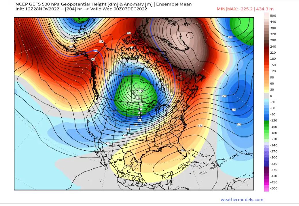
amugs wrote:The PNA goes neutral to slightly Positive - big win if it occurs for snow chances to the coastal plain. We have a stout Negative NAO (greenLand Block) and a Aluetian Block (Negative EPO) with a piece of the PV sitting over Hudson Bay. A very nice set up again IF it comes to fruitoin - we have all 3 globals saying so at this time.
This really doesn't look like a true -EPO alignment. IMO the Ridge needs to be N of the Aleutian Islands. So long as it is south of the Aleutians this will promote the tendency to place a trough along the WC of Canada and N CONUS and Pac energy will be constantly bombarding any attempted pos PNA spike. We need that ridge centered more over Alaska or at least over the Bering Sea, rather than south of the islands.

_________________
"In weather and in life, there's no winning and losing; there's only winning and learning."
WINTER 2012/2013 TOTALS 43.65"WINTER 2017/2018 TOTALS 62.85" WINTER 2022/2023 TOTALS 4.9"
WINTER 2013/2014 TOTALS 64.85"WINTER 2018/2019 TOTALS 14.25" WINTER 2023/2024 TOTALS 13.1"
WINTER 2014/2015 TOTALS 71.20"WINTER 2019/2020 TOTALS 6.35"
WINTER 2015/2016 TOTALS 35.00"WINTER 2020/2021 TOTALS 37.75"
WINTER 2016/2017 TOTALS 42.25"WINTER 2021/2022 TOTALS 31.65"
sroc4- Admin
- Posts : 8441
Reputation : 302
Join date : 2013-01-07
Location : Wading River, LI
Re: Long Range Thread 25.0
![]() by amugs Mon Nov 28, 2022 2:54 pm
by amugs Mon Nov 28, 2022 2:54 pm
I would like it further east to but hopefully in time we'll see it and move more east. So you have the elusive ridge bridge happening. If that isn't room for excitement I do not what is brother.
Momma will do what she wants and we'll accept it (some may not
_________________
Mugs
AKA:King: Snow Weenie
Self Proclaimed
WINTER 2014-15 : 55.12" +.02 for 6 coatings (avg. 35")
WINTER 2015-16 Total - 29.8" (Avg 35")
WINTER 2016-17 : 39.5" so far
amugs- Advanced Forecaster - Mod
- Posts : 15130
Reputation : 213
Join date : 2013-01-07
Age : 54
Location : Hillsdale,NJ
Re: Long Range Thread 25.0
![]() by heehaw453 Mon Nov 28, 2022 3:01 pm
by heehaw453 Mon Nov 28, 2022 3:01 pm
Good points on that. I don't believe there is going to be any major storm threat until the block retrogrades/breaks down more towards Hudson Bay and help the PNA with more amplification. It's one major reason I believe the substantial threat period is more mid-month than early month. What I believe to be different from last December 2021 1/we don't have the extreme hostile -PNA , 2/more favorable arctic domains at least as modelled. Now prior to mid-month as the blocking continues to cool the area there probably will be minor/moderate threats even at the coast as I don't think the PAC is that bad and it will be cold enough. I like 12/10-12/15ish for that and then from 12/17-12/25 something more substantial on the EC. This is the kind of blocking and PAC combo I've seen more often than not before a very wintry period on the EC. It's going to be interesting to see guidance in the next 10 days and hopefully it pans outsroc4 wrote:amugs wrote:The PNA goes neutral to slightly Positive - big win if it occurs for snow chances to the coastal plain. We have a stout Negative NAO (greenLand Block) and a Aluetian Block (Negative EPO) with a piece of the PV sitting over Hudson Bay. A very nice set up again IF it comes to fruitoin - we have all 3 globals saying so at this time.
This really doesn't look like a true -EPO alignment. IMO the Ridge needs to be N of the Aleutian Islands. So long as it is south of the Aleutians this will promote the tendency to place a trough along the WC of Canada and N CONUS and Pac energy will be constantly bombarding any attempted pos PNA spike. We need that ridge centered more over Alaska or at least over the Bering Sea, rather than south of the islands.
heehaw453- Advanced Forecaster
- Posts : 3907
Reputation : 86
Join date : 2014-01-20
Location : Bedminster Township, PA Elevation 600' ASL
sroc4 and amugs like this post
Re: Long Range Thread 25.0
![]() by amugs Mon Nov 28, 2022 3:10 pm
by amugs Mon Nov 28, 2022 3:10 pm
IF this occurs then peeps we gonna be busy!!!

_________________
Mugs
AKA:King: Snow Weenie
Self Proclaimed
WINTER 2014-15 : 55.12" +.02 for 6 coatings (avg. 35")
WINTER 2015-16 Total - 29.8" (Avg 35")
WINTER 2016-17 : 39.5" so far
amugs- Advanced Forecaster - Mod
- Posts : 15130
Reputation : 213
Join date : 2013-01-07
Age : 54
Location : Hillsdale,NJ
sroc4 likes this post
Page 4 of 40 • 1, 2, 3, 4, 5 ... 22 ... 40 ![]()
|
|
|