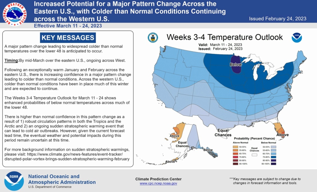
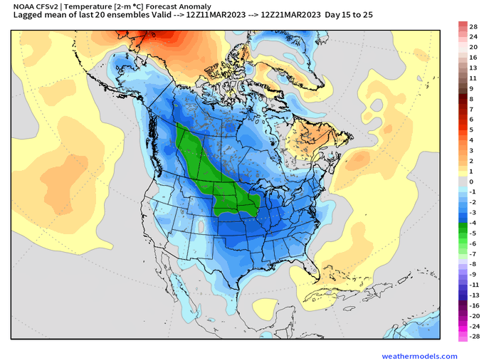
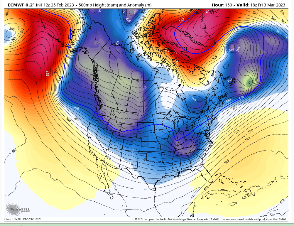
Long Range Thread 25.0
+42
toople
Coachgriff
Carvin
Scullybutcher
Wheezer
lglickman1
dolphins222
Grselig
Zhukov1945
aiannone
CPcantmeasuresnow
jimv45
JT33
TheAresian
Radz
brownie
SENJsnowman
billg315
hyde345
SoulSingMG
Math23x7
phil155
snowbunny
mmanisca
Abba701
MattyICE
GreyBeard
nutleyblizzard
heehaw453
weatherwatchermom
HectorO
jmanley32
Irish
dkodgis
Dunnzoo
sroc4
algae888
Frank_Wx
kalleg
frank 638
docstox12
amugs
46 posters
Page 37 of 40
Page 37 of 40 •  1 ... 20 ... 36, 37, 38, 39, 40
 Re: Long Range Thread 25.0
I'd like to see alot too but we have to take what we can get and hope the block is a tad stronger along with 50/50 thatbwould help. PAC is not ready to help until a few days later as it looks to transition.
amugs- Advanced Forecaster - Mod

- Posts : 15095
Join date : 2013-01-07
 Re: Long Range Thread 25.0
This is what I mean, a positive trend over the past 3 runs. Needs this to hold and keep ticking west with the ridge and the NAO block and 50/50 build the confluence to shove the SW more S. If we get these going then things improve on the surface depiction more.amugs wrote:
I'd like to see alot too but we have to take what we can get and hope the block is a tad stronger along with 50/50 thatbwould help. PAC is not ready to help until a few days later as it looks to transition.
From 33nRain board Brooklyn

amugs- Advanced Forecaster - Mod

- Posts : 15095
Join date : 2013-01-07
 Re: Long Range Thread 25.0
_________________
Mugs
AKA:King: Snow Weenie
Self Proclaimed
WINTER 2014-15 : 55.12" +.02 for 6 coatings (avg. 35")
WINTER 2015-16 Total - 29.8" (Avg 35")
WINTER 2016-17 : 39.5" so far

amugs- Advanced Forecaster - Mod

- Posts : 15095
Reputation : 213
Join date : 2013-01-07
Age : 54
Location : Hillsdale,NJ
heehaw453- Advanced Forecaster

- Posts : 3906
Reputation : 86
Join date : 2014-01-20
Location : Bedminster Township, PA Elevation 600' ASL
 Re: Long Range Thread 25.0
Weenie snow maps incoming for March? something lacking all winter long…
Radz- Pro Enthusiast

- Posts : 1028
Reputation : 17
Join date : 2013-01-12
Location : Cortlandt Manor NY
 Re: Long Range Thread 25.0
I am still seeing warm air in Central NJ…at this point I’d say we are out of the mix on this one….let’s put a pin in this Winter and bring on the 60’s and 70’s.

Coachgriff- Posts : 57
Reputation : 0
Join date : 2022-01-29
weatherwatchermom likes this post
 Re: Long Range Thread 25.0
Well, we are on the cusp of when the wheels have come off of what appeared in the LR to be promising. SOI is -16 this am. Gut tells me we miss out but to not look away yet. By we I mean the coastal plain and south. As we approach Sunday if SOI is still negative we may be in for a surprise. I mean the soi isnts the end all be all but it is def an indicator that the trop pac forcing has changed assuming it persists in the negative. Even though it’s changed it still may not work out for the coast but the outcome for many “should” be different….again IF is stays negative.
If your model watching one of the trends all season has been undermodeled southern energy that trends stronger and bullies it’s way too far north and west flooding the mid levels with warmth.
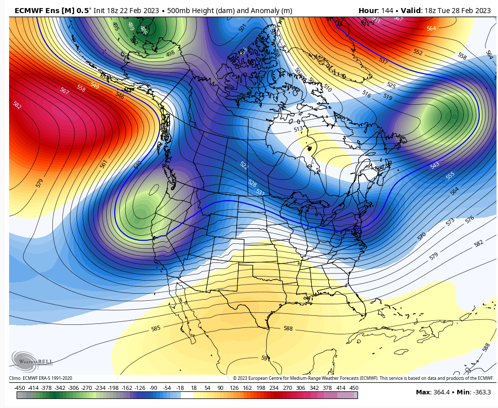
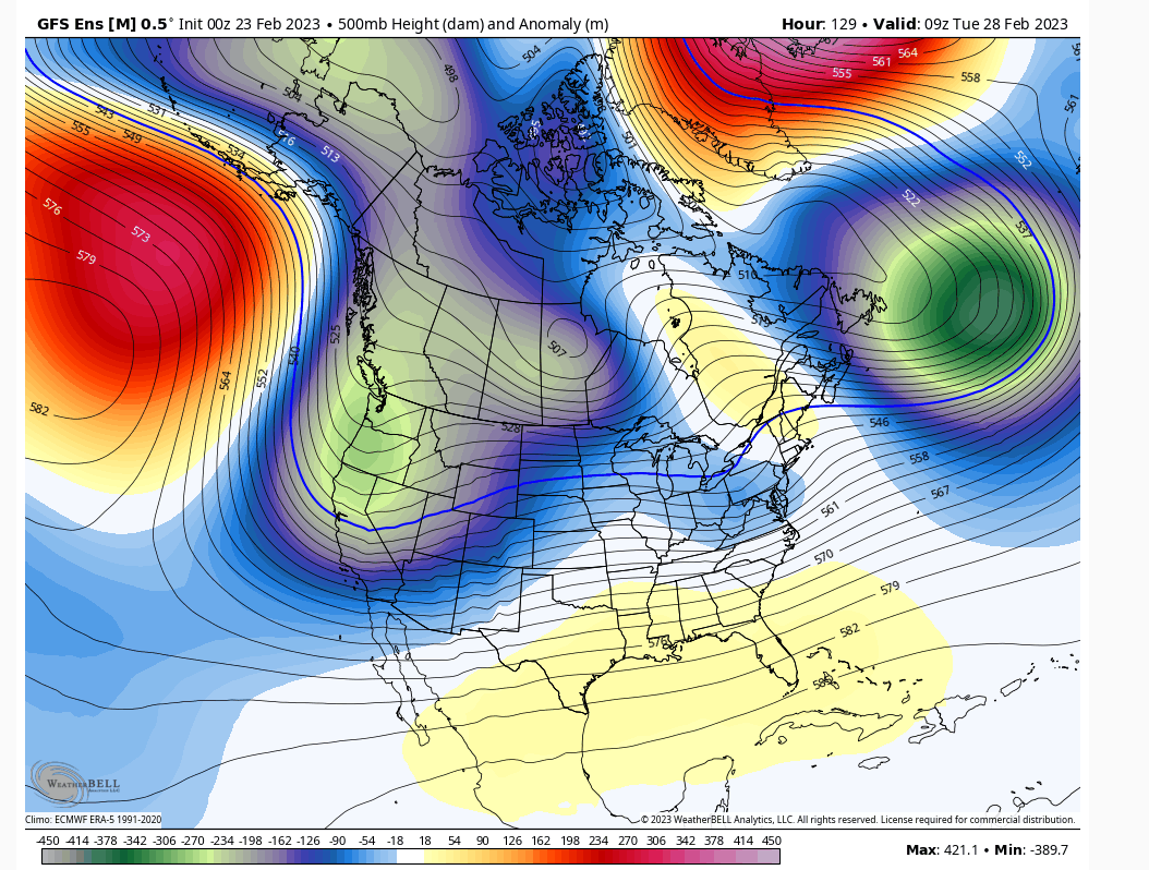
What seems to be happening is we get 500mb energy to cut off and head to our NW, but as it runs into the blocking, negative NAO and 50/50 low it opens up and becomes an open trough that then moves east. To me the key is when does the ULL open up. When it does the trough seems to be with a negative orientation which would benefit most of everyone. I really don’t think we need a closed 500mb low to pass to our south to work. We just need the block to hold strong enough to open things up before it gains too much latitude and then let a negative trough do its dirty work so long as its base is far enough south .
Last edited by sroc4 on Thu Feb 23, 2023 9:06 am; edited 1 time in total
_________________
"In weather and in life, there's no winning and losing; there's only winning and learning."
WINTER 2012/2013 TOTALS 43.65"WINTER 2017/2018 TOTALS 62.85" WINTER 2022/2023 TOTALS 4.9"
WINTER 2013/2014 TOTALS 64.85"WINTER 2018/2019 TOTALS 14.25" WINTER 2023/2024 TOTALS 13.1"
WINTER 2014/2015 TOTALS 71.20"WINTER 2019/2020 TOTALS 6.35"
WINTER 2015/2016 TOTALS 35.00"WINTER 2020/2021 TOTALS 37.75"
WINTER 2016/2017 TOTALS 42.25"WINTER 2021/2022 TOTALS 31.65"

sroc4- Admin

- Posts : 8354
Reputation : 302
Join date : 2013-01-07
Location : Wading River, LI
MattyICE likes this post
 Re: Long Range Thread 25.0
Agree with you! Sig event though IMO is going to require an injection of energy into the ULL before it hits coast as the ULL opened up and weakens. And I'd like to see that ULL around DE/Maryland. That will rapidly deepen mid and surface low pressure in time for the area. Without that latitude and injection I see this as minor perhaps nothing (coastal plain) to maybe minor/moderate event north of Rt 80. Get that injection into the ULL and keep it lower latitude then it's another animal all together.sroc4 wrote:Well, we are on the cusp of when the wheels have come off of what appeared in the LR to be promising. SOI is -16 this am. Gut tells me we miss out but to not look away yet. By we I mean the coastal plain and south. As we approach Sunday if SOI is still negative we may be in for a surprise. I mean the soi isnts the end all be all but it is def an indicator that the trop pac forcing has changed assuming it persists in the negative. Even though it’s changed it still may not work out for the coast but the outcome for many “should” be different….again IF is stays negative.
If your model watching one of the trends all season has been undermodeled southern energy that trends stronger and bullies it’s way too far north and west flooding the mid levels with warmth.
What seems to be happening is we get 500mb energy to cut off and head to our NW, but as it runs into the blocking, negative NAO and 50/50 low it opens up and becomes an open trough that then moves east. To me the key is when does the ULL open up. When it does the trough seems to be with a negative orientation which would benefit most of everyone. I really don’t think we need a closed 500mb low to pass to our south to work. We just need the block to hold strong enough to open things up before it gains too much latitude and then let a negative trough do its dirty work so long as its base is far enough south.
heehaw453- Advanced Forecaster

- Posts : 3906
Reputation : 86
Join date : 2014-01-20
Location : Bedminster Township, PA Elevation 600' ASL
sroc4 and MattyICE like this post
 Re: Long Range Thread 25.0
It still seems to be something for everyone to watch although if you are latitude south of the city chances diminish for every 10 Miles South. North of the city, and I don’t mean Yonkers, I mean 20 miles and more north of the city certainly bears watching.
Right now the trusty weather app which is never correct, has my area which is 50 miles north of New York City for 6 to 9 inches of snow Monday night and Tuesday morning. Since I’ve already seen several of these this season on the weather app and stand right now with the 4/10 of an inch of snow that fell yesterday at 8 inches for the season, I of course have 0% confidence in the 6 to 9 inches that it currently shows. Of course there are Maps right now from the euro GFS and CMC that would verify those amounts. In the winter of nothing I will believe all of those maps on Tuesday morning should this event even materialize.
Right now the trusty weather app which is never correct, has my area which is 50 miles north of New York City for 6 to 9 inches of snow Monday night and Tuesday morning. Since I’ve already seen several of these this season on the weather app and stand right now with the 4/10 of an inch of snow that fell yesterday at 8 inches for the season, I of course have 0% confidence in the 6 to 9 inches that it currently shows. Of course there are Maps right now from the euro GFS and CMC that would verify those amounts. In the winter of nothing I will believe all of those maps on Tuesday morning should this event even materialize.

CPcantmeasuresnow- Wx Statistician Guru

- Posts : 7274
Reputation : 230
Join date : 2013-01-07
Age : 103
Location : Eastern Orange County, NY
docstox12, dkodgis, heehaw453 and weatherwatchermom like this post
 Re: Long Range Thread 25.0
I’d sooner trust the president of these United States than the weatherman.

dkodgis- Senior Enthusiast

- Posts : 2560
Reputation : 98
Join date : 2013-12-29
docstox12 likes this post
 Re: Long Range Thread 25.0
dkodgis wrote:I’d sooner trust the president of these United States than the weatherman.
I wouldn't go that far.
_________________
"In weather and in life, there's no winning and losing; there's only winning and learning."
WINTER 2012/2013 TOTALS 43.65"WINTER 2017/2018 TOTALS 62.85" WINTER 2022/2023 TOTALS 4.9"
WINTER 2013/2014 TOTALS 64.85"WINTER 2018/2019 TOTALS 14.25" WINTER 2023/2024 TOTALS 13.1"
WINTER 2014/2015 TOTALS 71.20"WINTER 2019/2020 TOTALS 6.35"
WINTER 2015/2016 TOTALS 35.00"WINTER 2020/2021 TOTALS 37.75"
WINTER 2016/2017 TOTALS 42.25"WINTER 2021/2022 TOTALS 31.65"

sroc4- Admin

- Posts : 8354
Reputation : 302
Join date : 2013-01-07
Location : Wading River, LI
docstox12 and billg315 like this post
 Re: Long Range Thread 25.0
Is anything significant for the coastal plain off the table even in the best case scenario?
lglickman1- Pro Enthusiast

- Posts : 319
Reputation : 0
Join date : 2013-02-05
Location : New Rochelle, NY
 Re: Long Range Thread 25.0
As heehaw says, how far south this thing develops probably tells the tale. If it pops up off the NJ coast -- too far north to get us what we need. But if it is south of here . . . so we're saying there's a chance?
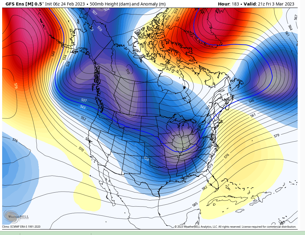
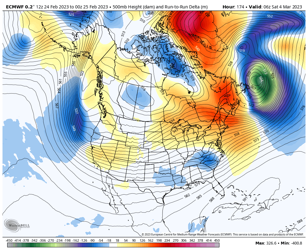
Also, I put no faith in model runs several days out as we've seen time and again this winter, but that modeled storm the first weekend of March takes the more Miller-A track that most of our big March storms have in the past. If you want to be optimistic, maybe some of the longer-range positive signs we've been looking for are showing up in that system.
Also, I put no faith in model runs several days out as we've seen time and again this winter, but that modeled storm the first weekend of March takes the more Miller-A track that most of our big March storms have in the past. If you want to be optimistic, maybe some of the longer-range positive signs we've been looking for are showing up in that system.

billg315- Advanced Forecaster - Mod

- Posts : 4483
Reputation : 185
Join date : 2015-01-24
Age : 50
Location : Flemington, NJ
heehaw453 likes this post
heehaw453- Advanced Forecaster

- Posts : 3906
Reputation : 86
Join date : 2014-01-20
Location : Bedminster Township, PA Elevation 600' ASL
heehaw453- Advanced Forecaster

- Posts : 3906
Reputation : 86
Join date : 2014-01-20
Location : Bedminster Township, PA Elevation 600' ASL
phil155 likes this post
 Re: Long Range Thread 25.0
Modeling has zero ridging to the west. Blocking to the NE allows this thing to Miller B, aka primary transferring to the coast. As of now the secondary forms and tracks just south of LI. Not horrible at this lead time.
But with any ridge to the west, PNA is exceptionally negative throughout the time frame it appears at least to me for now that there isn't a real mechanism to allow this thing to deepen much as the secondary slips by.
Coast is df not out of some snow just yet but N&W def seems better situated with this one.
_________________
"In weather and in life, there's no winning and losing; there's only winning and learning."
WINTER 2012/2013 TOTALS 43.65"WINTER 2017/2018 TOTALS 62.85" WINTER 2022/2023 TOTALS 4.9"
WINTER 2013/2014 TOTALS 64.85"WINTER 2018/2019 TOTALS 14.25" WINTER 2023/2024 TOTALS 13.1"
WINTER 2014/2015 TOTALS 71.20"WINTER 2019/2020 TOTALS 6.35"
WINTER 2015/2016 TOTALS 35.00"WINTER 2020/2021 TOTALS 37.75"
WINTER 2016/2017 TOTALS 42.25"WINTER 2021/2022 TOTALS 31.65"

sroc4- Admin

- Posts : 8354
Reputation : 302
Join date : 2013-01-07
Location : Wading River, LI
phil155 likes this post
 Re: Long Range Thread 25.0
There are two storms to track. One for Monday into Tuesday, and another for next weekend (March 3rd-4th). Use the everyday discussion thread to talk about Monday's storm, and we'll keep this one focused on next weekend.
I'm not particularly high on either, but if I had to choose, Tuesday's storm has higher potential to deliver than next weekend does...
I'm not particularly high on either, but if I had to choose, Tuesday's storm has higher potential to deliver than next weekend does...
_________________
_______________________________________________________________________________________________________
CLICK HERE to view NJ Strong Snowstorm Classifications
heehaw453- Advanced Forecaster

- Posts : 3906
Reputation : 86
Join date : 2014-01-20
Location : Bedminster Township, PA Elevation 600' ASL
docstox12, kalleg and phil155 like this post
 Re: Long Range Thread 25.0
Frank_Wx wrote:There are two storms to track. One for Monday into Tuesday, and another for next weekend (March 3rd-4th). Use the everyday discussion thread to talk about Monday's storm, and we'll keep this one focused on next weekend.
I'm not particularly high on either, but if I had to choose, Tuesday's storm has higher potential to deliver than next weekend does...
Hey Frank Im big time hoping the European has a better handle on the March 4'th storm and the GFS is doing its usual nonsense. We are having our daughters baby shower that day at a restaurant to celebrate the twins she is pregnant with. I'll be looking at the insight from all on the board!!

mmanisca- Pro Enthusiast

- Posts : 299
Reputation : 3
Join date : 2013-01-23
Age : 65
Location : Deer Park, Long Island
sroc4 and docstox12 like this post
 Re: Long Range Thread 25.0
mmanisca wrote:Frank_Wx wrote:There are two storms to track. One for Monday into Tuesday, and another for next weekend (March 3rd-4th). Use the everyday discussion thread to talk about Monday's storm, and we'll keep this one focused on next weekend.
I'm not particularly high on either, but if I had to choose, Tuesday's storm has higher potential to deliver than next weekend does...
Hey Frank Im big time hoping the European has a better handle on the March 4'th storm and the GFS is doing its usual nonsense. We are having our daughters baby shower that day at a restaurant to celebrate the twins she is pregnant with. I'll be looking at the insight from all on the board!!
Congrats Manisca. Thats wonderful. IF we get a big snowstorm that day we all will be sure to thank you personally for the planning of such a joyous event and setting that up for the rest of us. Lol You know...Murphy's law.
_________________
"In weather and in life, there's no winning and losing; there's only winning and learning."
WINTER 2012/2013 TOTALS 43.65"WINTER 2017/2018 TOTALS 62.85" WINTER 2022/2023 TOTALS 4.9"
WINTER 2013/2014 TOTALS 64.85"WINTER 2018/2019 TOTALS 14.25" WINTER 2023/2024 TOTALS 13.1"
WINTER 2014/2015 TOTALS 71.20"WINTER 2019/2020 TOTALS 6.35"
WINTER 2015/2016 TOTALS 35.00"WINTER 2020/2021 TOTALS 37.75"
WINTER 2016/2017 TOTALS 42.25"WINTER 2021/2022 TOTALS 31.65"

sroc4- Admin

- Posts : 8354
Reputation : 302
Join date : 2013-01-07
Location : Wading River, LI
mmanisca likes this post
 Re: Long Range Thread 25.0
Thank you for making it clear that Yonkers will be screwed lol, on a side note the 12z GFS gives NYC north a good 4-6+, I will take a nice 4-6 if it were to happen. Nothing too crazy but a nice change for once this year, that 0 on my signature is just sad. Lol at todays 12z GFS snow map, def weenie fantasy map between the two storms, 2nd one is a all out ice festival, i think the ice is being counted as snow. No I am not taking anything verbatim, as one model run to another shows completely different outcomes even for 28th.CPcantmeasuresnow wrote:It still seems to be something for everyone to watch although if you are latitude south of the city chances diminish for every 10 Miles South. North of the city, and I don’t mean Yonkers, I mean 20 miles and more north of the city certainly bears watching.
Right now the trusty weather app which is never correct, has my area which is 50 miles north of New York City for 6 to 9 inches of snow Monday night and Tuesday morning. Since I’ve already seen several of these this season on the weather app and stand right now with the 4/10 of an inch of snow that fell yesterday at 8 inches for the season, I of course have 0% confidence in the 6 to 9 inches that it currently shows. Of course there are Maps right now from the euro GFS and CMC that would verify those amounts. In the winter of nothing I will believe all of those maps on Tuesday morning should this event even materialize.

jmanley32- Senior Enthusiast

- Posts : 20535
Reputation : 108
Join date : 2013-12-12
Age : 43
Location : Yonkers, NY
 Re: Long Range Thread 25.0
sroc4 wrote:mmanisca wrote:Frank_Wx wrote:There are two storms to track. One for Monday into Tuesday, and another for next weekend (March 3rd-4th). Use the everyday discussion thread to talk about Monday's storm, and we'll keep this one focused on next weekend.
I'm not particularly high on either, but if I had to choose, Tuesday's storm has higher potential to deliver than next weekend does...
Hey Frank Im big time hoping the European has a better handle on the March 4'th storm and the GFS is doing its usual nonsense. We are having our daughters baby shower that day at a restaurant to celebrate the twins she is pregnant with. I'll be looking at the insight from all on the board!!
Congrats Manisca. Thats wonderful. IF we get a big snowstorm that day we all will be sure to thank you personally for the planning of such a joyous event and setting that up for the rest of us. Lol You know...Murphy's law.
Well I’m going wit more of a euro look perhaps out of necessity but yeah Murphys law says the gfs will be right this time. UGH…

mmanisca- Pro Enthusiast

- Posts : 299
Reputation : 3
Join date : 2013-01-23
Age : 65
Location : Deer Park, Long Island
 Re: Long Range Thread 25.0
_________________
Mugs
AKA:King: Snow Weenie
Self Proclaimed
WINTER 2014-15 : 55.12" +.02 for 6 coatings (avg. 35")
WINTER 2015-16 Total - 29.8" (Avg 35")
WINTER 2016-17 : 39.5" so far

amugs- Advanced Forecaster - Mod

- Posts : 15095
Reputation : 213
Join date : 2013-01-07
Age : 54
Location : Hillsdale,NJ
 Re: Long Range Thread 25.0
_________________
Mugs
AKA:King: Snow Weenie
Self Proclaimed
WINTER 2014-15 : 55.12" +.02 for 6 coatings (avg. 35")
WINTER 2015-16 Total - 29.8" (Avg 35")
WINTER 2016-17 : 39.5" so far

amugs- Advanced Forecaster - Mod

- Posts : 15095
Reputation : 213
Join date : 2013-01-07
Age : 54
Location : Hillsdale,NJ
 Re: Long Range Thread 25.0
I'm intrigued by the potential system next weekend primarily because it is a very different storm track from what we've seen most of this season. If there is some cold air to draw from, it could be a very favorable track for us given what we've seen in past March storms.

billg315- Advanced Forecaster - Mod

- Posts : 4483
Reputation : 185
Join date : 2015-01-24
Age : 50
Location : Flemington, NJ
 Re: Long Range Thread 25.0
Also interesting because we are on the cusp (supposedly) of this pattern change. One wonders if a big storm could be what heralds that change.

billg315- Advanced Forecaster - Mod

- Posts : 4483
Reputation : 185
Join date : 2015-01-24
Age : 50
Location : Flemington, NJ
heehaw453- Advanced Forecaster

- Posts : 3906
Reputation : 86
Join date : 2014-01-20
Location : Bedminster Township, PA Elevation 600' ASL
sroc4 likes this post
Page 37 of 40 •  1 ... 20 ... 36, 37, 38, 39, 40
Page 37 of 40
Permissions in this forum:
You cannot reply to topics in this forum|
|
|

 Home
Home