
 Search
Long Range Thread 26.0
Page 1 of 6 • 1, 2, 3, 4, 5, 6 ![]()

Long Range Thread 26.0
![]() by Frank_Wx Thu Mar 02, 2023 2:36 pm
by Frank_Wx Thu Mar 02, 2023 2:36 pm
Some INTERESTING times unfolding in the mid to late March time frame. A west based -NAO forms and suppresses the SE ridge.

MUCH thanks for a very prominent MJO wave that has mostly hurt us this year, but is destined to carry through phases 7 and 8 which bolds extremely well for our pattern.
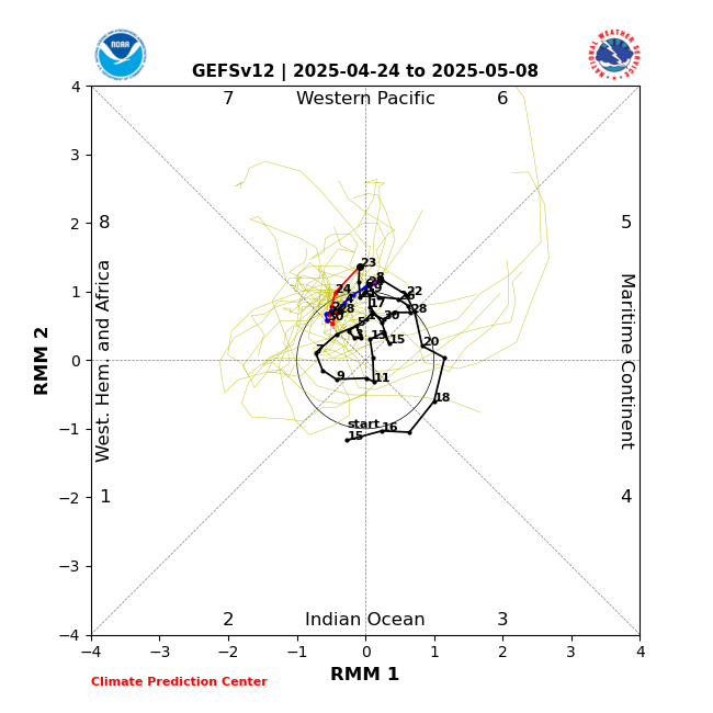
I think what I'm looking for next on modeling is for Pacific support. With the MJO progressing favorably, we'll have a -NAO and cross-polar flow across the CONUS. The emergence of either a -EPO or +PNA would catapult the pattern from GOOD to GREAT and set us up nicely for a potential winter storm in the middle/later part of the month.
_________________
_______________________________________________________________________________________________________
CLICK HERE to view NJ Strong Snowstorm Classifications

Frank_Wx- Godzilla Seeker

- Posts : 21308
Reputation : 328
Join date : 2013-01-05
Age : 32
Location : Jersey City, NJ -

weatherwatchermom and billg315 like this post
Re: Long Range Thread 26.0
![]() by amugs Thu Mar 02, 2023 5:11 pm
by amugs Thu Mar 02, 2023 5:11 pm

_________________
Mugs
AKA:King: Snow Weenie
Self Proclaimed
WINTER 2014-15 : 55.12" +.02 for 6 coatings (avg. 35")
WINTER 2015-16 Total - 29.8" (Avg 35")
WINTER 2016-17 : 39.5" so far

amugs- Advanced Forecaster - Mod

- Posts : 15130
Reputation : 213
Join date : 2013-01-07
Age : 54
Location : Hillsdale,NJ
Re: Long Range Thread 26.0
![]() by sroc4 Thu Mar 02, 2023 5:29 pm
by sroc4 Thu Mar 02, 2023 5:29 pm
amugs wrote:Here is your map for that call Frank:
_________________
"In weather and in life, there's no winning and losing; there's only winning and learning."
WINTER 2012/2013 TOTALS 43.65"WINTER 2017/2018 TOTALS 62.85" WINTER 2022/2023 TOTALS 4.9"
WINTER 2013/2014 TOTALS 64.85"WINTER 2018/2019 TOTALS 14.25" WINTER 2023/2024 TOTALS 13.1"
WINTER 2014/2015 TOTALS 71.20"WINTER 2019/2020 TOTALS 6.35"
WINTER 2015/2016 TOTALS 35.00"WINTER 2020/2021 TOTALS 37.75"
WINTER 2016/2017 TOTALS 42.25"WINTER 2021/2022 TOTALS 31.65"

sroc4- Admin
- Posts : 8441
Reputation : 302
Join date : 2013-01-07
Location : Wading River, LI
Re: Long Range Thread 26.0
![]() by heehaw453 Thu Mar 02, 2023 7:16 pm
by heehaw453 Thu Mar 02, 2023 7:16 pm
heehaw453- Advanced Forecaster

- Posts : 3907
Reputation : 86
Join date : 2014-01-20
Location : Bedminster Township, PA Elevation 600' ASL
Re: Long Range Thread 26.0
![]() by Radz Fri Mar 03, 2023 7:01 am
by Radz Fri Mar 03, 2023 7:01 am

Radz- Pro Enthusiast

- Posts : 1028
Reputation : 17
Join date : 2013-01-12
Location : Cortlandt Manor NY
Grselig and phil155 like this post
Re: Long Range Thread 26.0
![]() by phil155 Fri Mar 03, 2023 8:30 am
by phil155 Fri Mar 03, 2023 8:30 am
phil155- Pro Enthusiast
- Posts : 494
Reputation : 4
Join date : 2019-12-16
Radz, Grselig and weatherwatchermom like this post
Re: Long Range Thread 26.0
![]() by heehaw453 Fri Mar 03, 2023 12:11 pm
by heehaw453 Fri Mar 03, 2023 12:11 pm

heehaw453- Advanced Forecaster
- Posts : 3907
Reputation : 86
Join date : 2014-01-20
Location : Bedminster Township, PA Elevation 600' ASL
Radz, SENJsnowman and phil155 like this post
Re: Long Range Thread 26.0
![]() by sroc4 Fri Mar 03, 2023 1:25 pm
by sroc4 Fri Mar 03, 2023 1:25 pm
heehaw453 wrote:All righty then. Ensembles are barking for end of next week into weekend. It's the kind of look where someone on EC gets a 1'+.
Dont sleep on a sneaky little clipper system for overnight hours Monday into Tuesday.
_________________
"In weather and in life, there's no winning and losing; there's only winning and learning."
WINTER 2012/2013 TOTALS 43.65"WINTER 2017/2018 TOTALS 62.85" WINTER 2022/2023 TOTALS 4.9"
WINTER 2013/2014 TOTALS 64.85"WINTER 2018/2019 TOTALS 14.25" WINTER 2023/2024 TOTALS 13.1"
WINTER 2014/2015 TOTALS 71.20"WINTER 2019/2020 TOTALS 6.35"
WINTER 2015/2016 TOTALS 35.00"WINTER 2020/2021 TOTALS 37.75"
WINTER 2016/2017 TOTALS 42.25"WINTER 2021/2022 TOTALS 31.65"
sroc4- Admin
- Posts : 8441
Reputation : 302
Join date : 2013-01-07
Location : Wading River, LI
amugs and kalleg like this post
Re: Long Range Thread 26.0
![]() by amugs Fri Mar 03, 2023 1:51 pm
by amugs Fri Mar 03, 2023 1:51 pm
SROC you read my mind brother GFS and EURO are onto this as I came onto to post the 12z EURO!!sroc4 wrote:heehaw453 wrote:All righty then. Ensembles are barking for end of next week into weekend. It's the kind of look where someone on EC gets a 1'+.
Dont sleep on a sneaky little clipper system for overnight hours Monday into Tuesday.

_________________
Mugs
AKA:King: Snow Weenie
Self Proclaimed
WINTER 2014-15 : 55.12" +.02 for 6 coatings (avg. 35")
WINTER 2015-16 Total - 29.8" (Avg 35")
WINTER 2016-17 : 39.5" so far
amugs- Advanced Forecaster - Mod
- Posts : 15130
Reputation : 213
Join date : 2013-01-07
Age : 54
Location : Hillsdale,NJ
sroc4, kalleg and phil155 like this post
Re: Long Range Thread 26.0
![]() by heehaw453 Fri Mar 03, 2023 2:28 pm
by heehaw453 Fri Mar 03, 2023 2:28 pm
Remember when clippers where a thing around here? Been a while since one produced, but yeah in this setup the block can push the s/w down and the 50/50 road blocks the Atlantic. That's how those little critters can become big critters.sroc4 wrote:heehaw453 wrote:All righty then. Ensembles are barking for end of next week into weekend. It's the kind of look where someone on EC gets a 1'+.
Dont sleep on a sneaky little clipper system for overnight hours Monday into Tuesday.

heehaw453- Advanced Forecaster
- Posts : 3907
Reputation : 86
Join date : 2014-01-20
Location : Bedminster Township, PA Elevation 600' ASL
kalleg likes this post
Re: Long Range Thread 26.0
![]() by Frank_Wx Fri Mar 03, 2023 3:42 pm
by Frank_Wx Fri Mar 03, 2023 3:42 pm


_________________
_______________________________________________________________________________________________________
CLICK HERE to view NJ Strong Snowstorm Classifications
Frank_Wx- Godzilla Seeker
- Posts : 21308
Reputation : 328
Join date : 2013-01-05
Age : 32
Location : Jersey City, NJ -
Re: Long Range Thread 26.0
![]() by amugs Fri Mar 03, 2023 7:03 pm
by amugs Fri Mar 03, 2023 7:03 pm
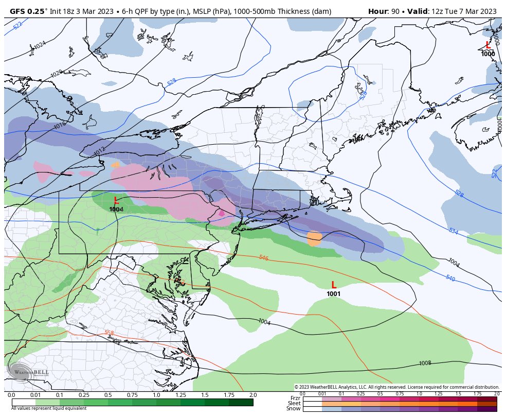
Frank_Wx wrote:The clipper as advertised on the EURO would bring some snow to the area
GFS say hello!
_________________
Mugs
AKA:King: Snow Weenie
Self Proclaimed
WINTER 2014-15 : 55.12" +.02 for 6 coatings (avg. 35")
WINTER 2015-16 Total - 29.8" (Avg 35")
WINTER 2016-17 : 39.5" so far
amugs- Advanced Forecaster - Mod
- Posts : 15130
Reputation : 213
Join date : 2013-01-07
Age : 54
Location : Hillsdale,NJ
Re: Long Range Thread 26.0
![]() by phil155 Fri Mar 03, 2023 8:21 pm
by phil155 Fri Mar 03, 2023 8:21 pm
phil155- Pro Enthusiast
- Posts : 494
Reputation : 4
Join date : 2019-12-16
Re: Long Range Thread 26.0
![]() by CPcantmeasuresnow Fri Mar 03, 2023 8:25 pm
by CPcantmeasuresnow Fri Mar 03, 2023 8:25 pm
phil155 wrote:Sadly looks like rain for most of the state
What state? NY and CT look ok. Even NNJ in the snow.
Last edited by CPcantmeasuresnow on Sat Mar 04, 2023 12:05 am; edited 1 time in total

CPcantmeasuresnow- Wx Statistician Guru

- Posts : 7274
Reputation : 230
Join date : 2013-01-07
Age : 103
Location : Eastern Orange County, NY
Re: Long Range Thread 26.0
![]() by lglickman1 Fri Mar 03, 2023 8:42 pm
by lglickman1 Fri Mar 03, 2023 8:42 pm
lglickman1- Pro Enthusiast
- Posts : 319
Reputation : 0
Join date : 2013-02-05
Location : New Rochelle, NY
Re: Long Range Thread 26.0
![]() by nutleyblizzard Sat Mar 04, 2023 7:13 am
by nutleyblizzard Sat Mar 04, 2023 7:13 am

nutleyblizzard- Senior Enthusiast

- Posts : 1963
Reputation : 41
Join date : 2014-01-30
Age : 58
Location : Nutley, new jersey
CPcantmeasuresnow likes this post
Re: Long Range Thread 26.0
![]() by heehaw453 Sat Mar 04, 2023 7:28 am
by heehaw453 Sat Mar 04, 2023 7:28 am

heehaw453- Advanced Forecaster
- Posts : 3907
Reputation : 86
Join date : 2014-01-20
Location : Bedminster Township, PA Elevation 600' ASL
Re: Long Range Thread 26.0
![]() by heehaw453 Sat Mar 04, 2023 7:45 am
by heehaw453 Sat Mar 04, 2023 7:45 am

heehaw453- Advanced Forecaster
- Posts : 3907
Reputation : 86
Join date : 2014-01-20
Location : Bedminster Township, PA Elevation 600' ASL
sroc4 likes this post
Re: Long Range Thread 26.0
![]() by heehaw453 Sat Mar 04, 2023 10:03 am
by heehaw453 Sat Mar 04, 2023 10:03 am
The GFS a bit different with the evolution of the s/w and wants to cut it because it's digging instead of moving eastward. These sig differences will be resolved within next 3 or 4 cycles IMO and that'll determine if there's a threat or not.

heehaw453- Advanced Forecaster
- Posts : 3907
Reputation : 86
Join date : 2014-01-20
Location : Bedminster Township, PA Elevation 600' ASL
CPcantmeasuresnow and kalleg like this post
Re: Long Range Thread 26.0
![]() by nutleyblizzard Sat Mar 04, 2023 10:50 am
by nutleyblizzard Sat Mar 04, 2023 10:50 am
So anywhere from a Great Lakes cutter to a slow moving East coast KU event is on the board. Got it.heehaw453 wrote:As per 06Z EPS for next weekend whatever s/w gets ejected out of the PAC is going move rather slowly when it hits the EC. One heck of a western NAO block and just as impressive Atlantic trough pinned between two ridges.
The GFS a bit different with the evolution of the s/w and wants to cut it because it's digging instead of moving eastward. These sig differences will be resolved within next 3 or 4 cycles IMO and that'll determine if there's a threat or not.
nutleyblizzard- Senior Enthusiast
- Posts : 1963
Reputation : 41
Join date : 2014-01-30
Age : 58
Location : Nutley, new jersey
Re: Long Range Thread 26.0
![]() by heehaw453 Sat Mar 04, 2023 11:29 am
by heehaw453 Sat Mar 04, 2023 11:29 am
If I had to guess right now (way too early of course) goal posts based on the synoptic setup I'd put this as inland runner to inside BM ULL track. That puts this as an I-81 to I-95 special.nutleyblizzard wrote:So anywhere from a Great Lakes cutter to a slow moving East coast KU event is on the board. Got it.heehaw453 wrote:As per 06Z EPS for next weekend whatever s/w gets ejected out of the PAC is going move rather slowly when it hits the EC. One heck of a western NAO block and just as impressive Atlantic trough pinned between two ridges.
The GFS a bit different with the evolution of the s/w and wants to cut it because it's digging instead of moving eastward. These sig differences will be resolved within next 3 or 4 cycles IMO and that'll determine if there's a threat or not.
heehaw453- Advanced Forecaster
- Posts : 3907
Reputation : 86
Join date : 2014-01-20
Location : Bedminster Township, PA Elevation 600' ASL
CPcantmeasuresnow likes this post
Re: Long Range Thread 26.0
![]() by heehaw453 Sat Mar 04, 2023 3:25 pm
by heehaw453 Sat Mar 04, 2023 3:25 pm

heehaw453- Advanced Forecaster
- Posts : 3907
Reputation : 86
Join date : 2014-01-20
Location : Bedminster Township, PA Elevation 600' ASL
Re: Long Range Thread 26.0
![]() by chief7 Sun Mar 05, 2023 6:12 am
by chief7 Sun Mar 05, 2023 6:12 am
Last edited by chief7 on Sun Mar 05, 2023 6:14 am; edited 1 time in total
chief7- Posts : 132
Reputation : 0
Join date : 2013-11-10
Location : Langhorne pa
Re: Long Range Thread 26.0
![]() by nutleyblizzard Sun Mar 05, 2023 6:17 am
by nutleyblizzard Sun Mar 05, 2023 6:17 am

EURO with massive changes last night. The trough out west is much weaker and opens up at OZ allowing the SW to cut underneath the block which results in a strong coastal low. The OP showed a two footer, and the EPS that followed shows a lot of big hits as we well. The GFS and GEFS while not showing this wild scenario as of now, did show some baby steps towards the EURO idea.
nutleyblizzard- Senior Enthusiast
- Posts : 1963
Reputation : 41
Join date : 2014-01-30
Age : 58
Location : Nutley, new jersey
Re: Long Range Thread 26.0
![]() by heehaw453 Sun Mar 05, 2023 6:44 am
by heehaw453 Sun Mar 05, 2023 6:44 am
Nice write up. The Euro has been somewhat consistent at the h5 IMO. The s/w gets ejected out of the PAC as a wave break and moves along. It's the ridge behind the s/w that is somewhat in question. More defined ridge probably means a much stronger storm that will dive under us instead of want to reform like what it showed yesterday. the reform scenario is much less potent for our area.nutleyblizzard wrote:
EURO with massive changes last night. The trough out west is much weaker and opens up at OZ allowing the SW to cut underneath the block which results in a strong coastal low. The OP showed a two footer, and the EPS that followed shows a lot of big hits as we well. The GFS and GEFS while not showing this wild scenario as of now, did show some baby steps towards the EURO idea.
The key to this storm is right here IMO in the PNA. The other features I'm feeling good about NAO/Atlantic trough. Let's hope.

heehaw453- Advanced Forecaster
- Posts : 3907
Reputation : 86
Join date : 2014-01-20
Location : Bedminster Township, PA Elevation 600' ASL
Page 1 of 6 • 1, 2, 3, 4, 5, 6 ![]()
|
|
|