Long Range Thread 26.0
+20
Grselig
hyde345
billg315
jmanley32
dkodgis
Quietace
crippo84
SoulSingMG
Carvin
SENJsnowman
chief7
nutleyblizzard
lglickman1
CPcantmeasuresnow
phil155
Radz
heehaw453
sroc4
amugs
Frank_Wx
24 posters
Page 6 of 6 •  1, 2, 3, 4, 5, 6
 Re: Long Range Thread 26.0
MJO off the charts Phase 8 = BN Temps and Stormy possiblities EC
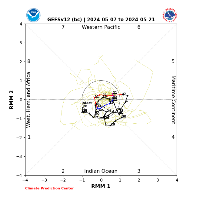
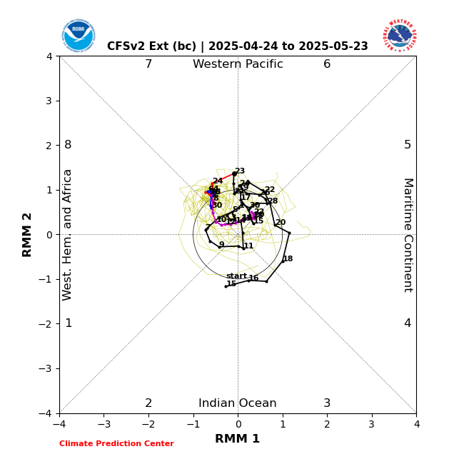
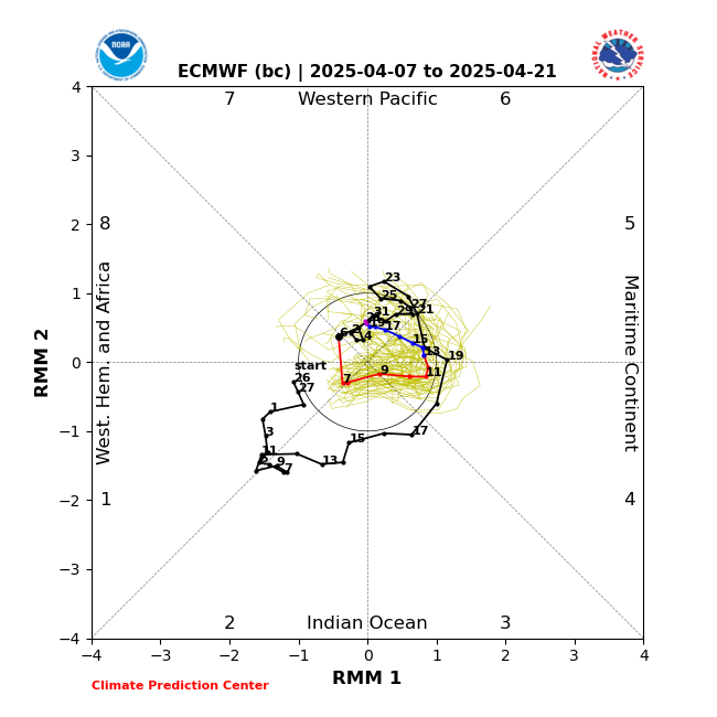
Phase 1 and 2 for March are good - 2 is excellent = SPRING DENIED for a few days to maybe week !!!
!!!


Phase 1 and 2 for March are good - 2 is excellent = SPRING DENIED for a few days to maybe week
amugs- Advanced Forecaster - Mod

- Posts : 15130
Join date : 2013-01-07
heehaw453 likes this post
 Re: Long Range Thread 26.0
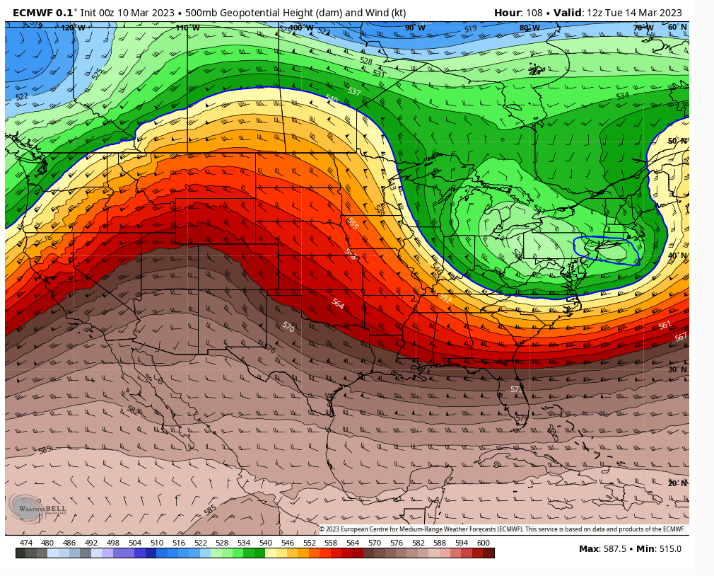
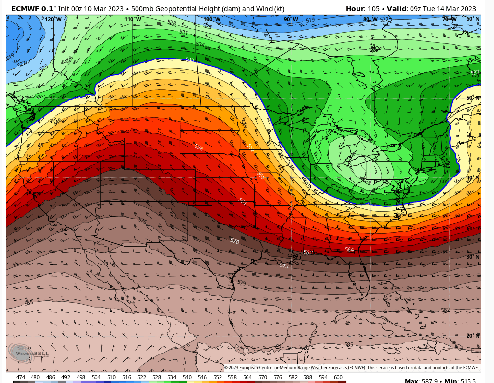
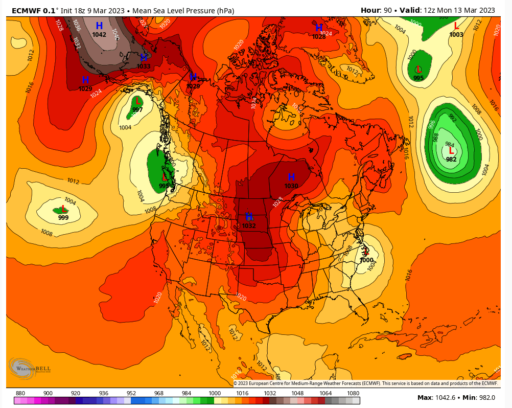
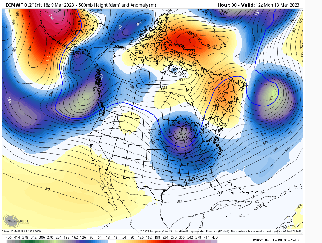
18Z Euro
Trying to analyze surface map. There are some intriguing ingredients.
Surface Low starting to intensify off OBX. Banana H in the mid-west and stout 50/50 blocking up the Atlantic. Also weak CAD bleeding down from New England.
Then looking at the 500mb you have a ridge developing just to the west of the Rockies.
You'd have me with this if we had the 1035 H over Quebec fully extending that banana H. But we rely on phasing to suck in the n/s. I guess I'm warming up a bit to this...


heehaw453- Advanced Forecaster

- Posts : 3907
Join date : 2014-01-20
dkodgis likes this post
 Re: Long Range Thread 26.0
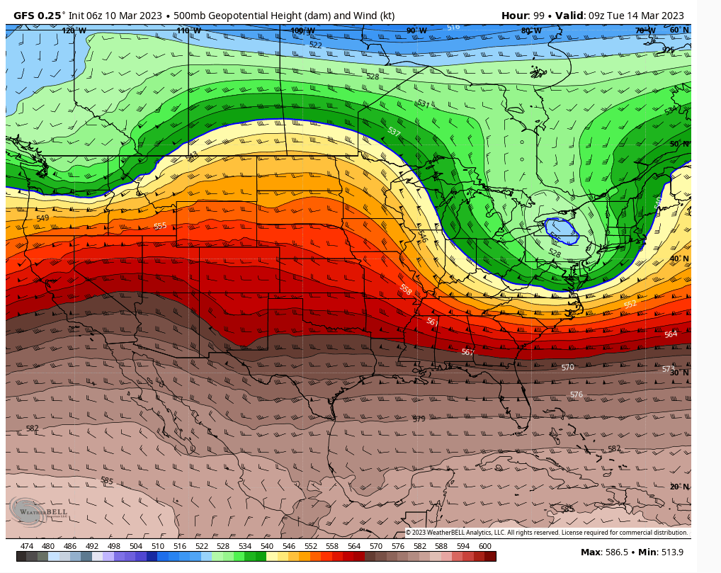
Morning. Quick update. Biggest difference between GFS and Euro basically comes down to how they are handling the western ridge.
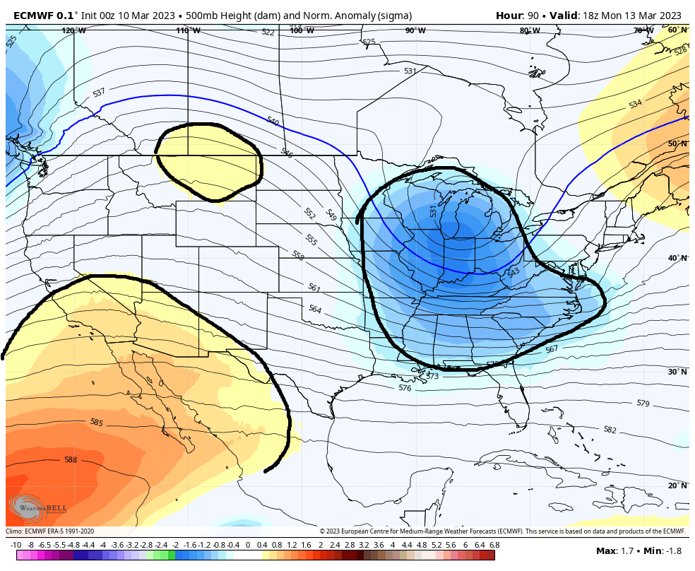
Below is the 500mb height anomaly maps representing 2pmMonday. Notice the difference in the strength of the oranges in the S west between GFS and Euro. Also notice the little circle of Orange on the euro vs GFS does not have it over Montana. What this tell me is that by Monday 2pm euro is building a western ridge and the GFS is not. And start to pay attention to the blue circled in the eastern third of the CONUS. This is our mean trough.

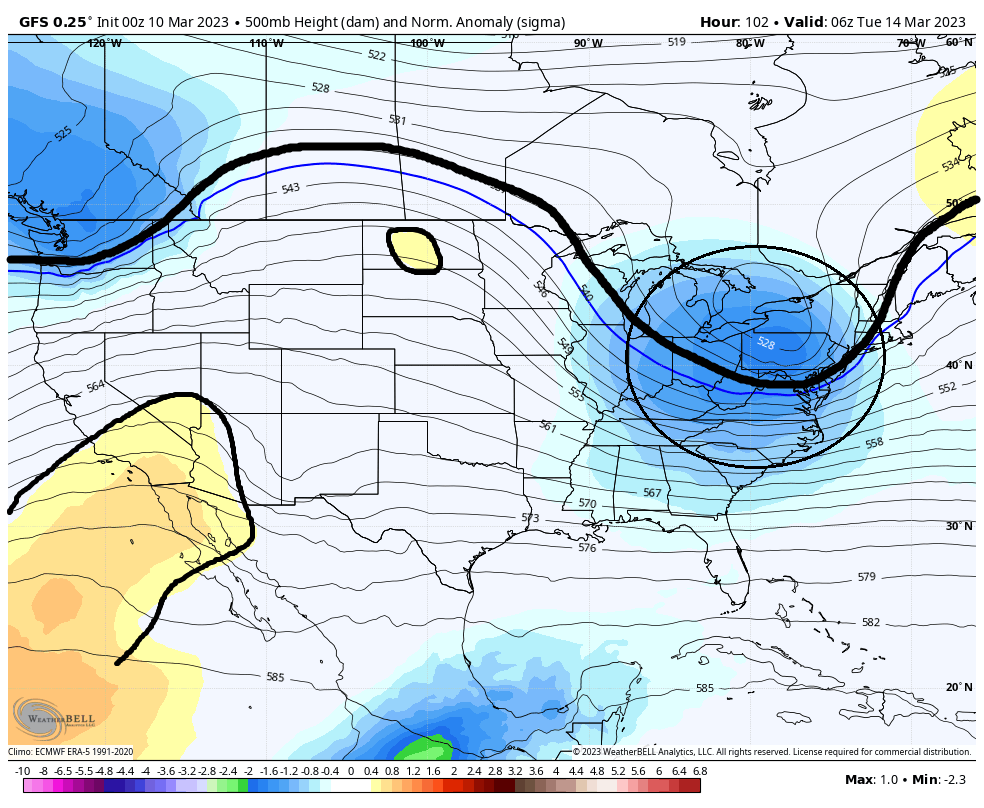
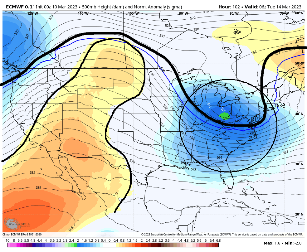
Fast forward approx 12hrs to 2am Tuesday. Now take notice how the GFS is just beginning to develop some orange in the northern tear of the CONUS whereas, the euro is now trying to connect the warm colors in the SW and N. Again this signifies a much more robust ridge to our west. The direct consequence of the more robust ridge is the blues much darker and deeper into the S&E
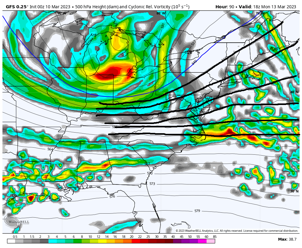
Going back to 2pm Monday maps lets look at the vorticity maps at 500mb. The result of a weaker vs stronger ridge out west means the difference between no phasing and weaker S energy with flatter 500mb heights along the EC, and losing some of the S energy OTS VS phasing, stronger S energy that raises heights along the EC drawing that energy up the coast.

Looking at the surface map the differences between no phasing and phasing at 500mb is a much weaker slp exiting the EC much further S headed ENE to NE (GFS) because of the progressive flow and positive to neutral trough tilt VS a much stronger slp exiting the EC further N with a trajectory to the NE to NNE because its being pulled in by the phased system that has a negative tilted trough.
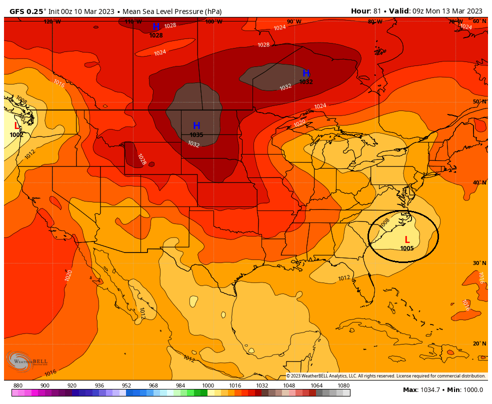

So again to summarize I think both GFS and Euro have the N Atlantic blocked up indicating eventually there will be a phase. But currently the GFS has a weaker trough development to the west so the mean trough cannot dig early enough resulting in a phase that ends up being a little late and overall less impactful system. However, the euro builds a more robust ridge in the west which results in a mean trough that digs earlier phasing the N and S energy early enough to develop a much more robust slp bringing it up the coast as a potent and rapidly deepening system that will be very impactful system one way or another. Details for the our coverage area is still way up in the air so please for the love of all that is holy do not ask if you think a particular snow map soln can happen for any particular backyards yet.
Just as a PS if you will, the GFS ensembles supports its operational soln, and the European ensembles supports its operational soln. As you can see in the images below the GFS ENS have an avg slp between 995-1000mb; whereas, the Euro Avg slp is in the 980's.


So there is a cross roads still out thee. FWIW the euro has handles the upper levels for tonight's system over the past 3 days much better than the GFS. Remember the GFS had a strong system with snow to the coast for tonight just a fw days ago and it moved to the euro sln. Lets see if the same holds true for this upcoming system and we see the GFS trend towards a stronger western ridge and a more potent phased soln
WE TRACK!!!

Below is the 500mb height anomaly maps representing 2pmMonday. Notice the difference in the strength of the oranges in the S west between GFS and Euro. Also notice the little circle of Orange on the euro vs GFS does not have it over Montana. What this tell me is that by Monday 2pm euro is building a western ridge and the GFS is not. And start to pay attention to the blue circled in the eastern third of the CONUS. This is our mean trough.


Fast forward approx 12hrs to 2am Tuesday. Now take notice how the GFS is just beginning to develop some orange in the northern tear of the CONUS whereas, the euro is now trying to connect the warm colors in the SW and N. Again this signifies a much more robust ridge to our west. The direct consequence of the more robust ridge is the blues much darker and deeper into the S&E


Going back to 2pm Monday maps lets look at the vorticity maps at 500mb. The result of a weaker vs stronger ridge out west means the difference between no phasing and weaker S energy with flatter 500mb heights along the EC, and losing some of the S energy OTS VS phasing, stronger S energy that raises heights along the EC drawing that energy up the coast.


Looking at the surface map the differences between no phasing and phasing at 500mb is a much weaker slp exiting the EC much further S headed ENE to NE (GFS) because of the progressive flow and positive to neutral trough tilt VS a much stronger slp exiting the EC further N with a trajectory to the NE to NNE because its being pulled in by the phased system that has a negative tilted trough.


So again to summarize I think both GFS and Euro have the N Atlantic blocked up indicating eventually there will be a phase. But currently the GFS has a weaker trough development to the west so the mean trough cannot dig early enough resulting in a phase that ends up being a little late and overall less impactful system. However, the euro builds a more robust ridge in the west which results in a mean trough that digs earlier phasing the N and S energy early enough to develop a much more robust slp bringing it up the coast as a potent and rapidly deepening system that will be very impactful system one way or another. Details for the our coverage area is still way up in the air so please for the love of all that is holy do not ask if you think a particular snow map soln can happen for any particular backyards yet.
Just as a PS if you will, the GFS ensembles supports its operational soln, and the European ensembles supports its operational soln. As you can see in the images below the GFS ENS have an avg slp between 995-1000mb; whereas, the Euro Avg slp is in the 980's.


So there is a cross roads still out thee. FWIW the euro has handles the upper levels for tonight's system over the past 3 days much better than the GFS. Remember the GFS had a strong system with snow to the coast for tonight just a fw days ago and it moved to the euro sln. Lets see if the same holds true for this upcoming system and we see the GFS trend towards a stronger western ridge and a more potent phased soln
WE TRACK!!!

_________________
"In weather and in life, there's no winning and losing; there's only winning and learning."
WINTER 2012/2013 TOTALS 43.65"WINTER 2017/2018 TOTALS 62.85" WINTER 2022/2023 TOTALS 4.9"
WINTER 2013/2014 TOTALS 64.85"WINTER 2018/2019 TOTALS 14.25" WINTER 2023/2024 TOTALS 13.1"
WINTER 2014/2015 TOTALS 71.20"WINTER 2019/2020 TOTALS 6.35"
WINTER 2015/2016 TOTALS 35.00"WINTER 2020/2021 TOTALS 37.75"
WINTER 2016/2017 TOTALS 42.25"WINTER 2021/2022 TOTALS 31.65"

sroc4- Admin

- Posts : 8441
Reputation : 302
Join date : 2013-01-07
Location : Wading River, LI
dkodgis and SENJsnowman like this post
heehaw453- Advanced Forecaster

- Posts : 3907
Reputation : 86
Join date : 2014-01-20
Location : Bedminster Township, PA Elevation 600' ASL
 Re: Long Range Thread 26.0
Moved my post to its own thread
_________________
"In weather and in life, there's no winning and losing; there's only winning and learning."
WINTER 2012/2013 TOTALS 43.65"WINTER 2017/2018 TOTALS 62.85" WINTER 2022/2023 TOTALS 4.9"
WINTER 2013/2014 TOTALS 64.85"WINTER 2018/2019 TOTALS 14.25" WINTER 2023/2024 TOTALS 13.1"
WINTER 2014/2015 TOTALS 71.20"WINTER 2019/2020 TOTALS 6.35"
WINTER 2015/2016 TOTALS 35.00"WINTER 2020/2021 TOTALS 37.75"
WINTER 2016/2017 TOTALS 42.25"WINTER 2021/2022 TOTALS 31.65"

sroc4- Admin

- Posts : 8441
Reputation : 302
Join date : 2013-01-07
Location : Wading River, LI
 Re: Long Range Thread 26.0
Super informative thanks a lot.

crippo84- Posts : 383
Reputation : 20
Join date : 2013-11-07
Age : 40
Location : East Village, NYC
heehaw453- Advanced Forecaster

- Posts : 3907
Reputation : 86
Join date : 2014-01-20
Location : Bedminster Township, PA Elevation 600' ASL
 Re: Long Range Thread 26.0
Wake up everybody! The Euro, Ukmet, and CMC came in colder and show a MECS. GFS is slowly coming around as well.

nutleyblizzard- Senior Enthusiast

- Posts : 1963
Reputation : 41
Join date : 2014-01-30
Age : 58
Location : Nutley, new jersey
dkodgis likes this post
 Re: Long Range Thread 26.0
Let’s move the discussion to the thread Scott started
_________________
_______________________________________________________________________________________________________
CLICK HERE to view NJ Strong Snowstorm Classifications
 Re: Long Range Thread 26.0
I know many are still involved with today, and rightfully so, but just throwing this out here. Possibly one last dance around 22nd-24th as the MJO cycles through phase 1-2 and possibly into the Null phase. The end game perhaps? Long way off and not likely.


_________________
"In weather and in life, there's no winning and losing; there's only winning and learning."
WINTER 2012/2013 TOTALS 43.65"WINTER 2017/2018 TOTALS 62.85" WINTER 2022/2023 TOTALS 4.9"
WINTER 2013/2014 TOTALS 64.85"WINTER 2018/2019 TOTALS 14.25" WINTER 2023/2024 TOTALS 13.1"
WINTER 2014/2015 TOTALS 71.20"WINTER 2019/2020 TOTALS 6.35"
WINTER 2015/2016 TOTALS 35.00"WINTER 2020/2021 TOTALS 37.75"
WINTER 2016/2017 TOTALS 42.25"WINTER 2021/2022 TOTALS 31.65"

sroc4- Admin

- Posts : 8441
Reputation : 302
Join date : 2013-01-07
Location : Wading River, LI
kalleg likes this post
 Re: Long Range Thread 26.0
The models have been hinting at something along the east coast in that time frame so worth keeping an eye on; But I've been so disappointed with this season that I'm kind of in the I'll believe it when I see it stage of snow grief.

billg315- Advanced Forecaster - Mod

- Posts : 4531
Reputation : 185
Join date : 2015-01-24
Age : 50
Location : Flemington, NJ
SENJsnowman likes this post
 Re: Long Range Thread 26.0
billg315 wrote:The models have been hinting at something along the east coast in that time frame so worth keeping an eye on; But I've been so disappointed with this season that I'm kind of in the I'll believe it when I see it stage of snow grief.

_________________
"In weather and in life, there's no winning and losing; there's only winning and learning."
WINTER 2012/2013 TOTALS 43.65"WINTER 2017/2018 TOTALS 62.85" WINTER 2022/2023 TOTALS 4.9"
WINTER 2013/2014 TOTALS 64.85"WINTER 2018/2019 TOTALS 14.25" WINTER 2023/2024 TOTALS 13.1"
WINTER 2014/2015 TOTALS 71.20"WINTER 2019/2020 TOTALS 6.35"
WINTER 2015/2016 TOTALS 35.00"WINTER 2020/2021 TOTALS 37.75"
WINTER 2016/2017 TOTALS 42.25"WINTER 2021/2022 TOTALS 31.65"

sroc4- Admin

- Posts : 8441
Reputation : 302
Join date : 2013-01-07
Location : Wading River, LI
 Re: Long Range Thread 26.0
billg315 wrote:The models have been hinting at something along the east coast in that time frame so worth keeping an eye on; But I've been so disappointed with this season that I'm kind of in the I'll believe it when I see it stage of snow grief.
I see that Godzilla on the models next week. But what if it's another tease?

_________________
_______________________________________________________________________________________________________
CLICK HERE to view NJ Strong Snowstorm Classifications
billg315 likes this post
 Re: Long Range Thread 26.0
We may get 10 inches out of this when it’s done so I’ll take another tease like this. The journey has been torturous though. I’m still not sure where this goes from here. Sitting at 5.6 inches atm.
Actually Doc 5 miles from me has 7 inches.
Actually Doc 5 miles from me has 7 inches.
Last edited by CPcantmeasuresnow on Tue Mar 14, 2023 10:21 am; edited 1 time in total

CPcantmeasuresnow- Wx Statistician Guru

- Posts : 7274
Reputation : 230
Join date : 2013-01-07
Age : 103
Location : Eastern Orange County, NY
 Re: Long Range Thread 26.0
Frank_Wx wrote:billg315 wrote:The models have been hinting at something along the east coast in that time frame so worth keeping an eye on; But I've been so disappointed with this season that I'm kind of in the I'll believe it when I see it stage of snow grief.
I see that Godzilla on the models next week. But what if it's another tease?

ORRRRRRR I see that tease on the models next week, but what if its a Godzilla!!!!

_________________
"In weather and in life, there's no winning and losing; there's only winning and learning."
WINTER 2012/2013 TOTALS 43.65"WINTER 2017/2018 TOTALS 62.85" WINTER 2022/2023 TOTALS 4.9"
WINTER 2013/2014 TOTALS 64.85"WINTER 2018/2019 TOTALS 14.25" WINTER 2023/2024 TOTALS 13.1"
WINTER 2014/2015 TOTALS 71.20"WINTER 2019/2020 TOTALS 6.35"
WINTER 2015/2016 TOTALS 35.00"WINTER 2020/2021 TOTALS 37.75"
WINTER 2016/2017 TOTALS 42.25"WINTER 2021/2022 TOTALS 31.65"

sroc4- Admin

- Posts : 8441
Reputation : 302
Join date : 2013-01-07
Location : Wading River, LI
crippo84 and billg315 like this post
 Re: Long Range Thread 26.0
G’on get gone! If it is, JMan is buying

dkodgis- Senior Enthusiast

- Posts : 2661
Reputation : 98
Join date : 2013-12-29
billg315 likes this post
 Re: Long Range Thread 26.0
Frank_Wx wrote:billg315 wrote:The models have been hinting at something along the east coast in that time frame so worth keeping an eye on; But I've been so disappointed with this season that I'm kind of in the I'll believe it when I see it stage of snow grief.
I see that Godzilla on the models next week. But what if it's another tease?

Of course it will snow next week, I'll be in Florida.

_________________
Janet
Snowfall winter of 2023-2024 17.5"
Snowfall winter of 2022-2023 6.0"
Snowfall winter of 2021-2022 17.6" 1" sleet 2/25/22
Snowfall winter of 2020-2021 51.1"
Snowfall winter of 2019-2020 8.5"
Snowfall winter of 2018-2019 25.1"
Snowfall winter of 2017-2018 51.9"
Snowfall winter of 2016-2017 45.6"
Snowfall winter of 2015-2016 29.5"
Snowfall winter of 2014-2015 50.55"
Snowfall winter of 2013-2014 66.5"
Dunnzoo- Senior Enthusiast - Mod

- Posts : 4920
Reputation : 68
Join date : 2013-01-11
Age : 62
Location : Westwood, NJ
dkodgis and billg315 like this post
 Re: Long Range Thread 26.0
Janet, that looks like the Coconut Lounge.

dkodgis- Senior Enthusiast

- Posts : 2661
Reputation : 98
Join date : 2013-12-29
 Re: Long Range Thread 26.0
dkodgis wrote:Janet, that looks like the Coconut Lounge.
Will be stopping there on my way to Florida, have to check on the Volcano
_________________
Janet
Snowfall winter of 2023-2024 17.5"
Snowfall winter of 2022-2023 6.0"
Snowfall winter of 2021-2022 17.6" 1" sleet 2/25/22
Snowfall winter of 2020-2021 51.1"
Snowfall winter of 2019-2020 8.5"
Snowfall winter of 2018-2019 25.1"
Snowfall winter of 2017-2018 51.9"
Snowfall winter of 2016-2017 45.6"
Snowfall winter of 2015-2016 29.5"
Snowfall winter of 2014-2015 50.55"
Snowfall winter of 2013-2014 66.5"

Dunnzoo- Senior Enthusiast - Mod

- Posts : 4920
Reputation : 68
Join date : 2013-01-11
Age : 62
Location : Westwood, NJ
docstox12 and billg315 like this post
 Re: Long Range Thread 26.0
Wait why me lol, Nope no way I am going to pretend I heard that theres even something to possibly look at nope no way.dkodgis wrote:G’on get gone! If it is, JMan is buying

jmanley32- Senior Enthusiast

- Posts : 20635
Reputation : 108
Join date : 2013-12-12
Age : 43
Location : Yonkers, NY
 Re: Long Range Thread 26.0
Might we be tracking one more around 28th? the runs today were interesting but I am sure if anything were to happen would give the interior snow, doubt the coast has any shot. So many storm systems but none produce, well technically the last one did in fact it blitzed but it was just too warm, had it been really cold I might seen 6-12.

jmanley32- Senior Enthusiast

- Posts : 20635
Reputation : 108
Join date : 2013-12-12
Age : 43
Location : Yonkers, NY
kalleg likes this post
 Re: Long Range Thread 26.0
jmanley32 wrote:Might we be tracking one more around 28th? the runs today were interesting but I am sure if anything were to happen would give the interior snow, doubt the coast has any shot. So many storm systems but none produce, well technically the last one did in fact it blitzed but it was just too warm, had it been really cold I might seen 6-12.
Absolutely that last Nor was a MECS IF - the most important ingredient - had a true arctic air course.
_________________
Mugs
AKA:King: Snow Weenie
Self Proclaimed
WINTER 2014-15 : 55.12" +.02 for 6 coatings (avg. 35")
WINTER 2015-16 Total - 29.8" (Avg 35")
WINTER 2016-17 : 39.5" so far

amugs- Advanced Forecaster - Mod

- Posts : 15130
Reputation : 213
Join date : 2013-01-07
Age : 54
Location : Hillsdale,NJ
 Re: Long Range Thread 26.0
I do remember some years when I had to put plywood against my back garage wall to keep the snow off my crocuses and daffies. The forsythia is coming out here. So are the maple leaves. I am keeping a close eye on my hostas. Last year it was April 15. The year before, May 1. The year before, May 15 when hostas started peeping up out of the ground. If I do the math, and there continues to be a two-week trend, I will see hostas popping out about April 1. We'll see.

dkodgis- Senior Enthusiast

- Posts : 2661
Reputation : 98
Join date : 2013-12-29
weatherwatchermom likes this post
 Re: Long Range Thread 26.0
Didn't do the math but in 10 years Nov. 1st and winter will be nothing but a memory with sun and highs in the 70s pretty much from oct to may.dkodgis wrote:I do remember some years when I had to put plywood against my back garage wall to keep the snow off my crocuses and daffies. The forsythia is coming out here. So are the maple leaves. I am keeping a close eye on my hostas. Last year it was April 15. The year before, May 1. The year before, May 15 when hostas started peeping up out of the ground. If I do the math, and there continues to be a two-week trend, I will see hostas popping out about April 1. We'll see.

jmanley32- Senior Enthusiast

- Posts : 20635
Reputation : 108
Join date : 2013-12-12
Age : 43
Location : Yonkers, NY
 Re: Long Range Thread 26.0
Looks like a pretty cool and wet pattern for April?? Just a continuation of our non-winter conditions lol
Radz- Pro Enthusiast

- Posts : 1028
Reputation : 17
Join date : 2013-01-12
Location : Cortlandt Manor NY
kalleg likes this post
 Re: Long Range Thread 26.0
Looks like this Friday is going to be a gully washer.

dkodgis- Senior Enthusiast

- Posts : 2661
Reputation : 98
Join date : 2013-12-29
 Re: Long Range Thread 26.0
The annual closure of the long range thread begins today. We'll be back next Fall!
_________________
_______________________________________________________________________________________________________
CLICK HERE to view NJ Strong Snowstorm Classifications
sroc4, docstox12 and kalleg like this post
Page 6 of 6 •  1, 2, 3, 4, 5, 6
Permissions in this forum:
You cannot reply to topics in this forum|
|
|

 Home
Home