
 Search
Long Range Thread 26.0
Page 4 of 6 •  1, 2, 3, 4, 5, 6
 ![]()
Re: Long Range Thread 26.0
![]() by Quietace Wed Mar 08, 2023 6:35 am
by Quietace Wed Mar 08, 2023 6:35 am
SENJsnowman wrote:heehaw453 wrote:Euro 18Z Control. Storm undergoes bombogenesis. Again it may be too far offshore for a mega hit, but it's certainly close enough for intrigue. Certainly some CCB interest.
heehaw, correct me if I'm wrong...but isn't that exactly the image what a Jersey Shore coastie wants to see? I mean that's a 984 low, which is fairly strong, and the red freezing line is WAY offshore. Or no? Am I just looking at this through rose colored/bourbon altered glasses?


Low levels are going to torch with the strong east component to the wind. With the lack of any heavy precip, most southern areas even in a set up like that will likely not see accumulating snowfall. The set up this weekend is not conducive for snow in CNJ south.
A latitudinally transversing 500 hPa ULL, with strong WAA and southerly flow that leads to an overhead transfer (PA to off the JS for both the 850 hPA and 500 hPa lows) to an offshore, where all the favorable cyclogenic forcing is also offshore once temperatures cool via CAA from the wind shift, will not lead to any significant snows in the region. Once the coastal low is developed enough to form a mature precipitation shield, it is far to east to impact the region.
In fact, the overrunning from the initial ULL approach will likely drop more snow than this coastal storm unless significant changes occur on guidance.
Quietace- Meteorologist - Mod

- Posts : 3689
Join date : 2013-01-07
sroc4, heehaw453 and SENJsnowman like this post
Re: Long Range Thread 26.0
![]() by Frank_Wx Wed Mar 08, 2023 6:51 am
by Frank_Wx Wed Mar 08, 2023 6:51 am
The Monday-Tuesday storm has a chance to be special, but we’re dealing with some hiccups in the pattern. For one, the Saturday storm tries to “blow up” offshore and tries to become the 50-50 Low for the Monday storm. We have to watch this. The EURO amplifies heights along the EC enough to allow a northern and southern s/w phase, while GFS shows flatter heights as a result of Saturdays storm which keeps the Monday storm to our S&E.
The other thing to watch is western ridge. Currently one is being modeled but if it’s too quick to slide east or be too flat we’ll have issues with phasing, or this turns out to be a northern stream driven event which will only bring impact to areas N&W of NYC
Frank_Wx- Godzilla Seeker

- Posts : 21305
Join date : 2013-01-05 -

sroc4, heehaw453, SENJsnowman and Meepers55 like this post
Re: Long Range Thread 26.0
![]() by SENJsnowman Wed Mar 08, 2023 6:59 am
by SENJsnowman Wed Mar 08, 2023 6:59 am

And heehaw even mentioned parallels to the Jan/Feb '21 storm which brought a nice 5-6" front end dump down to the Shore, but then as the storm approached, it brought the rains I think all the way up a little north of 195.
OK...disappointing but not a bit surprising.
SENJsnowman- Senior Enthusiast

- Posts : 1189
Reputation : 61
Join date : 2017-01-06
Age : 51
Location : Bayville, NJ
Re: Long Range Thread 26.0
![]() by dkodgis Wed Mar 08, 2023 7:29 am
by dkodgis Wed Mar 08, 2023 7:29 am

dkodgis- Senior Enthusiast
- Posts : 2560
Reputation : 98
Join date : 2013-12-29
Re: Long Range Thread 26.0
![]() by heehaw453 Wed Mar 08, 2023 8:01 am
by heehaw453 Wed Mar 08, 2023 8:01 am
Yeah. This will be west of the fall line for accumulating snows. Beginning of next week would afford better potential for coastal plain, but that has way too much to iron out as the exact phasing mechanisms will determine if snow occurs. As usual I would favor interior for that too because we don't have a huge dome of cold air to work with IMO.SENJsnowman wrote:Thanks everyone for the feedback. Right after I posted last night, I looked at the Euro's temp profiles. 850 looked great. 700- great. That last one- the 2m surface temps told me the bad news right away:
And heehaw even mentioned parallels to the Jan/Feb '21 storm which brought a nice 5-6" front end dump down to the Shore, but then as the storm approached, it brought the rains I think all the way up a little north of 195.
OK...disappointing but not a bit surprising.
edit
what I meant by the 500mb comparison was for the next several waves not necessarily this one.
Last edited by heehaw453 on Wed Mar 08, 2023 8:11 am; edited 1 time in total
heehaw453- Advanced Forecaster

- Posts : 3906
Reputation : 86
Join date : 2014-01-20
Location : Bedminster Township, PA Elevation 600' ASL
SENJsnowman likes this post
Re: Long Range Thread 26.0
![]() by sroc4 Wed Mar 08, 2023 8:11 am
by sroc4 Wed Mar 08, 2023 8:11 am
Quietace wrote:SENJsnowman wrote:heehaw453 wrote:Euro 18Z Control. Storm undergoes bombogenesis. Again it may be too far offshore for a mega hit, but it's certainly close enough for intrigue. Certainly some CCB interest.
heehaw, correct me if I'm wrong...but isn't that exactly the image what a Jersey Shore coastie wants to see? I mean that's a 984 low, which is fairly strong, and the red freezing line is WAY offshore. Or no? Am I just looking at this through rose colored/bourbon altered glasses?
Low levels are going to torch with the strong east component to the wind. With the lack of any heavy precip, most southern areas even in a set up like that will likely not see accumulating snowfall. The set up this weekend is not conducive for snow in CNJ south.
A latitudinally transversing 500 hPa ULL, with strong WAA and southerly flow that leads to an overhead transfer (PA to off the JS for both the 850 hPA and 500 hPa lows) to an offshore, where all the favorable cyclogenic forcing is also offshore once temperatures cool via CAA from the wind shift, will not lead to any significant snows in the region. Once the coastal low is developed enough to form a mature precipitation shield, it is far to east to impact the region.
In fact, the overrunning from the initial ULL approach will likely drop more snow than this coastal storm unless significant changes occur on guidance.
I was coming on to make some similar points. Specifically the ones involving the current consensus of where the transferred coastal low forms and the fact that as it stands now the only real snow opportunity exists via the warm air advection(WAA) from the initial primary to our west. As the low transfers and reforms off the coast the trajectory is then E to ESE from there instead of having any sort of northerly component. This results in our area then sitting beneath the dreaded subsidence zone. Thats why, if anyone out there has scrolled through the model loop you see an initial surge of precip(WAA), but very quickly it looks to dissipate over only a few frames as the secondary takes over, matures and forms a nice mature precip shield around it from your standard CAA mechanisms, and as Ace points out too far S&E to affect the area.
And recall the discussion from yesterday. I posted this map showing how the GFS had the ULL interacting with the polar branch of the jet effectively opening the door to a cold air source; also causing the slp to be tugged a bit farther N and hence the colder soln, ie: the maturing precip shield actually over the coastal plain becuse the slp was further N.


On the other hand the Euro map I showed had a ridge to the N of our ULL effectively cutting off tthe cold air supply meaning we are dealing with primarily modified pacific air.

Well over night the GFS has trended towards that soln.

Up until yesterdays 12z models had trended more favorably; however, they still were still not ideal. It appears they have reached a threshold as to how far they trended toward a more wide spread favorable snow fall type soln. As it stands now it appears what snow does fall will be compliments of the initial WAA from the primary, followed by the secondary forming too far to the S&E to get any of us into the heavier precip shield that forms, and because the air mass is marginal at best, and because of the easterly fetch to the lower levels as the precip lightens up very quickly, esp over the coastal plain, we will likely see it transition to light rain or perhaps white rain as the mid levels do still look to remain cold enough. As Ace points out with the marginal air mass involved we need to be under the heavier precip in order to cool the lower levels enough to accumulate.
Im not quite ready to write off the system just yet, but the combo of the ridge over top, and the status/positioning of the 50/50 Low complex is such that it appears the ULL trajectory is too much in the ESE direction as it exits the coast which will make it very hard to get the secondary low to trend further N&W from where currently modeled. Again I believe we have to see the ULL interact some with the northern branch for this to happen but not sure we have the time left to do so.
_________________
"In weather and in life, there's no winning and losing; there's only winning and learning."
WINTER 2012/2013 TOTALS 43.65"WINTER 2017/2018 TOTALS 62.85" WINTER 2022/2023 TOTALS 4.9"
WINTER 2013/2014 TOTALS 64.85"WINTER 2018/2019 TOTALS 14.25" WINTER 2023/2024 TOTALS 13.1"
WINTER 2014/2015 TOTALS 71.20"WINTER 2019/2020 TOTALS 6.35"
WINTER 2015/2016 TOTALS 35.00"WINTER 2020/2021 TOTALS 37.75"
WINTER 2016/2017 TOTALS 42.25"WINTER 2021/2022 TOTALS 31.65"

sroc4- Admin
- Posts : 8354
Reputation : 302
Join date : 2013-01-07
Location : Wading River, LI
Frank_Wx and SENJsnowman like this post
Re: Long Range Thread 26.0
![]() by heehaw453 Wed Mar 08, 2023 8:22 am
by heehaw453 Wed Mar 08, 2023 8:22 am

heehaw453- Advanced Forecaster
- Posts : 3906
Reputation : 86
Join date : 2014-01-20
Location : Bedminster Township, PA Elevation 600' ASL
Frank_Wx likes this post
Re: Long Range Thread 26.0
![]() by dkodgis Wed Mar 08, 2023 9:38 am
by dkodgis Wed Mar 08, 2023 9:38 am
dkodgis- Senior Enthusiast
- Posts : 2560
Reputation : 98
Join date : 2013-12-29
Re: Long Range Thread 26.0
![]() by jmanley32 Wed Mar 08, 2023 10:11 am
by jmanley32 Wed Mar 08, 2023 10:11 am

jmanley32- Senior Enthusiast
- Posts : 20535
Reputation : 108
Join date : 2013-12-12
Age : 43
Location : Yonkers, NY
Re: Long Range Thread 26.0
![]() by jmanley32 Wed Mar 08, 2023 10:12 am
by jmanley32 Wed Mar 08, 2023 10:12 am
Why does it matter sounds like yet another rain event, too warm.dkodgis wrote:Looks like mid -afternoon to rush hour?
jmanley32- Senior Enthusiast
- Posts : 20535
Reputation : 108
Join date : 2013-12-12
Age : 43
Location : Yonkers, NY
Re: Long Range Thread 26.0
![]() by Frank_Wx Wed Mar 08, 2023 11:24 am
by Frank_Wx Wed Mar 08, 2023 11:24 am
jmanley32 wrote:Great analysis by all but I knew this wasn't going to work out at least for coast, not hyped but you all sounded super interested in this one, so I will assume Tuesday will be exactly the same and lose interest as we hit the weekend. I am ready for spring unless we can actually get a storm for the coast next week. After that I am done tracking, not reaching CP level stress (jk CP) but its just not really worth looking at and being let down what 20x this year?
jmanley32 wrote:Why does it matter sounds like yet another rain event, too warm.dkodgis wrote:Looks like mid -afternoon to rush hour?
Bring your negativity and banter to the banter thread. Thanks!
_________________
_______________________________________________________________________________________________________
CLICK HERE to view NJ Strong Snowstorm Classifications

Frank_Wx- Godzilla Seeker
- Posts : 21305
Reputation : 328
Join date : 2013-01-05
Age : 32
Location : Jersey City, NJ -
sroc4 likes this post
Re: Long Range Thread 26.0
![]() by Frank_Wx Wed Mar 08, 2023 11:26 am
by Frank_Wx Wed Mar 08, 2023 11:26 am
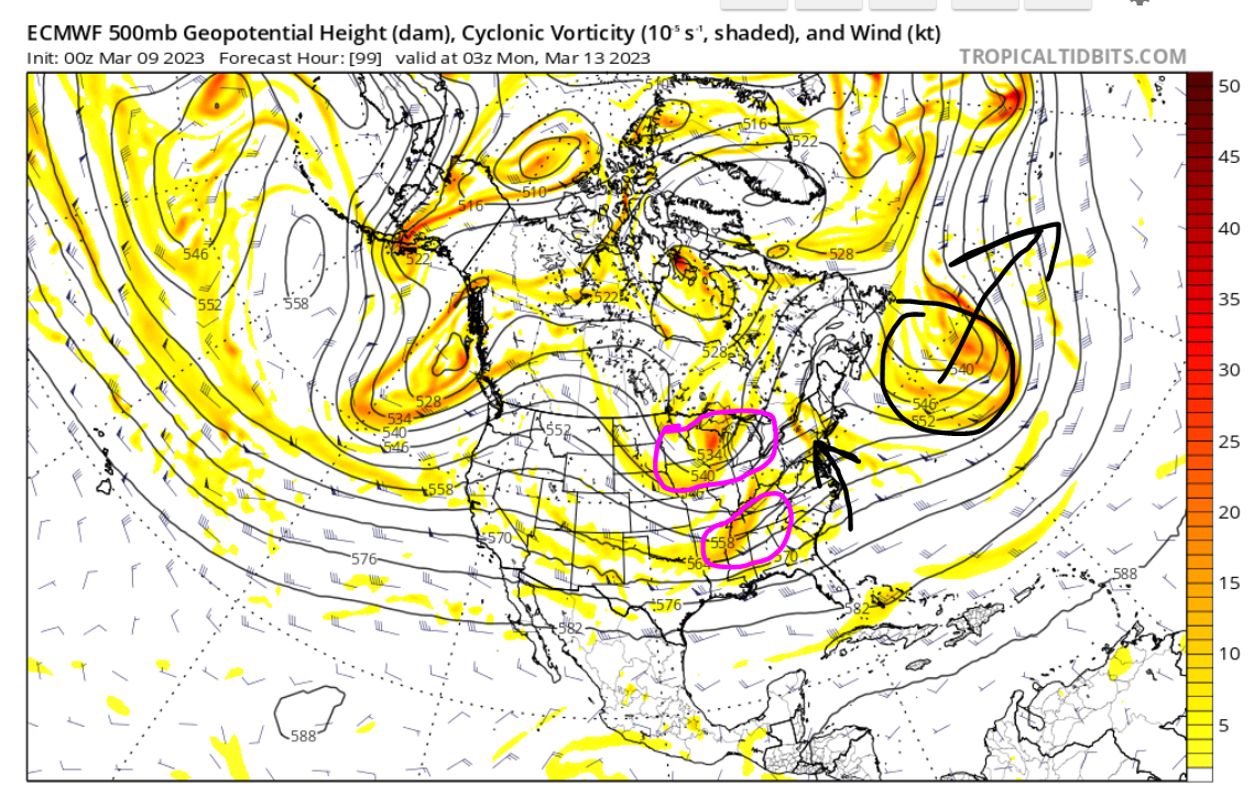
Check out this transfer of energy from western PA to off the coast. Pretty amazing how that works...


Yes the immediate coast is dealing with torched surface temps, but this looks like a nice snowfall for many areas.
_________________
_______________________________________________________________________________________________________
CLICK HERE to view NJ Strong Snowstorm Classifications
Frank_Wx- Godzilla Seeker
- Posts : 21305
Reputation : 328
Join date : 2013-01-05
Age : 32
Location : Jersey City, NJ -
kalleg and SENJsnowman like this post
dkodgis- Senior Enthusiast
- Posts : 2560
Reputation : 98
Join date : 2013-12-29
Re: Long Range Thread 26.0
![]() by billg315 Wed Mar 08, 2023 11:34 am
by billg315 Wed Mar 08, 2023 11:34 am
12z GFS still looks like it wants to develop a more potent secondary closer to the coast, bringing the totals in the above-mentioned areas up more to the 3-5" range and bringing some accumulation (an inch or two) even down to the coast.

billg315- Advanced Forecaster - Mod

- Posts : 4483
Reputation : 185
Join date : 2015-01-24
Age : 50
Location : Flemington, NJ
Re: Long Range Thread 26.0
![]() by billg315 Wed Mar 08, 2023 11:39 am
by billg315 Wed Mar 08, 2023 11:39 am
billg315- Advanced Forecaster - Mod
- Posts : 4483
Reputation : 185
Join date : 2015-01-24
Age : 50
Location : Flemington, NJ
Re: Long Range Thread 26.0
![]() by billg315 Wed Mar 08, 2023 11:48 am
by billg315 Wed Mar 08, 2023 11:48 am
dkodgis wrote:Looks like mid -afternoon to rush hour?
You're looking at snow starting by you Friday evening at 6 or 7 p.m. and continuing to about mid-morning/midday Saturday. And you're likely in a 2-4" range on either model.
billg315- Advanced Forecaster - Mod
- Posts : 4483
Reputation : 185
Join date : 2015-01-24
Age : 50
Location : Flemington, NJ
Re: Long Range Thread 26.0
![]() by hyde345 Wed Mar 08, 2023 12:05 pm
by hyde345 Wed Mar 08, 2023 12:05 pm

hyde345- Pro Enthusiast

- Posts : 1082
Reputation : 48
Join date : 2013-01-08
Location : Hyde Park, NY
Re: Long Range Thread 26.0
![]() by heehaw453 Wed Mar 08, 2023 2:10 pm
by heehaw453 Wed Mar 08, 2023 2:10 pm
heehaw453- Advanced Forecaster
- Posts : 3906
Reputation : 86
Join date : 2014-01-20
Location : Bedminster Township, PA Elevation 600' ASL
sroc4 and kalleg like this post
Re: Long Range Thread 26.0
![]() by Grselig Wed Mar 08, 2023 2:21 pm
by Grselig Wed Mar 08, 2023 2:21 pm
heehaw453 wrote:If there's going to be a surprise this winter on the upside this Friday night/Saturday may be it. Closed off ULL you just never know.
Hey. Tough winter for all of us. Thanks for staying on top of it. Really appreciate your insights. Hopefully Friday is a surprise.

Grselig- Senior Enthusiast
- Posts : 1408
Reputation : 140
Join date : 2013-03-04
Age : 54
Location : Wayne NJ
docstox12, kalleg and SENJsnowman like this post
Re: Long Range Thread 26.0
![]() by amugs Wed Mar 08, 2023 3:01 pm
by amugs Wed Mar 08, 2023 3:01 pm

Primary dies in OHV which is key - thanks to W NAO block:


Close Up


_________________
Mugs
AKA:King: Snow Weenie
Self Proclaimed
WINTER 2014-15 : 55.12" +.02 for 6 coatings (avg. 35")
WINTER 2015-16 Total - 29.8" (Avg 35")
WINTER 2016-17 : 39.5" so far

amugs- Advanced Forecaster - Mod
- Posts : 15095
Reputation : 213
Join date : 2013-01-07
Age : 54
Location : Hillsdale,NJ
Grselig likes this post
Re: Long Range Thread 26.0
![]() by essexcountypete Wed Mar 08, 2023 3:29 pm
by essexcountypete Wed Mar 08, 2023 3:29 pm

essexcountypete- Pro Enthusiast
- Posts : 783
Reputation : 12
Join date : 2013-12-09
Location : Bloomfield, NJ
kalleg, weatherwatchermom and phil155 like this post
Re: Long Range Thread 26.0
![]() by Frank_Wx Wed Mar 08, 2023 3:51 pm
by Frank_Wx Wed Mar 08, 2023 3:51 pm

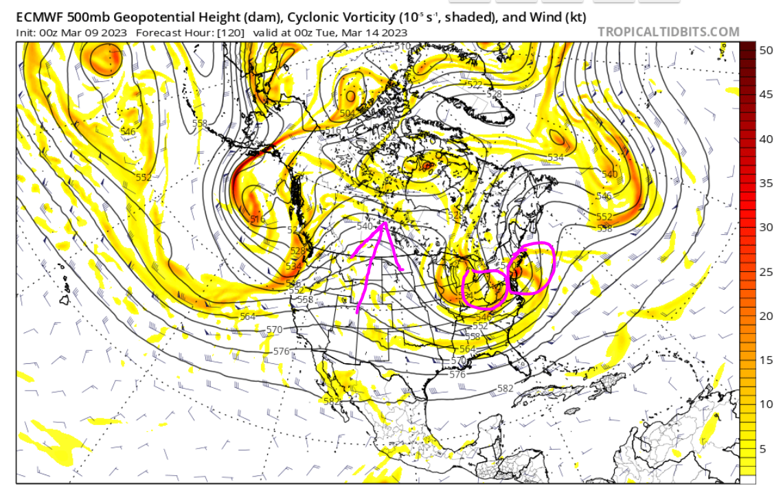
Funny enough, 500mb looked a little sloppy this run. There was some southern energy trying to scoot too far ahead of the trough. Ultimately a phase happened and we saw the trough go negative.
The GFS is just very fast and flat looking. Nothing comes together.
_________________
_______________________________________________________________________________________________________
CLICK HERE to view NJ Strong Snowstorm Classifications
Frank_Wx- Godzilla Seeker
- Posts : 21305
Reputation : 328
Join date : 2013-01-05
Age : 32
Location : Jersey City, NJ -
Re: Long Range Thread 26.0
![]() by Frank_Wx Wed Mar 08, 2023 3:57 pm
by Frank_Wx Wed Mar 08, 2023 3:57 pm
_________________
_______________________________________________________________________________________________________
CLICK HERE to view NJ Strong Snowstorm Classifications
Frank_Wx- Godzilla Seeker
- Posts : 21305
Reputation : 328
Join date : 2013-01-05
Age : 32
Location : Jersey City, NJ -
kalleg, 1190ftalt, SENJsnowman and JT33 like this post
Re: Long Range Thread 26.0
![]() by amugs Wed Mar 08, 2023 5:45 pm
by amugs Wed Mar 08, 2023 5:45 pm
GIF not uploading properly argghhh!!
_________________
Mugs
AKA:King: Snow Weenie
Self Proclaimed
WINTER 2014-15 : 55.12" +.02 for 6 coatings (avg. 35")
WINTER 2015-16 Total - 29.8" (Avg 35")
WINTER 2016-17 : 39.5" so far
amugs- Advanced Forecaster - Mod
- Posts : 15095
Reputation : 213
Join date : 2013-01-07
Age : 54
Location : Hillsdale,NJ
Re: Long Range Thread 26.0
![]() by heehaw453 Wed Mar 08, 2023 8:50 pm
by heehaw453 Wed Mar 08, 2023 8:50 pm

heehaw453- Advanced Forecaster
- Posts : 3906
Reputation : 86
Join date : 2014-01-20
Location : Bedminster Township, PA Elevation 600' ASL
Re: Long Range Thread 26.0
![]() by Radz Thu Mar 09, 2023 7:32 am
by Radz Thu Mar 09, 2023 7:32 am

Radz- Pro Enthusiast
- Posts : 1028
Reputation : 17
Join date : 2013-01-12
Location : Cortlandt Manor NY
Re: Long Range Thread 26.0
![]() by Frank_Wx Thu Mar 09, 2023 8:26 am
by Frank_Wx Thu Mar 09, 2023 8:26 am
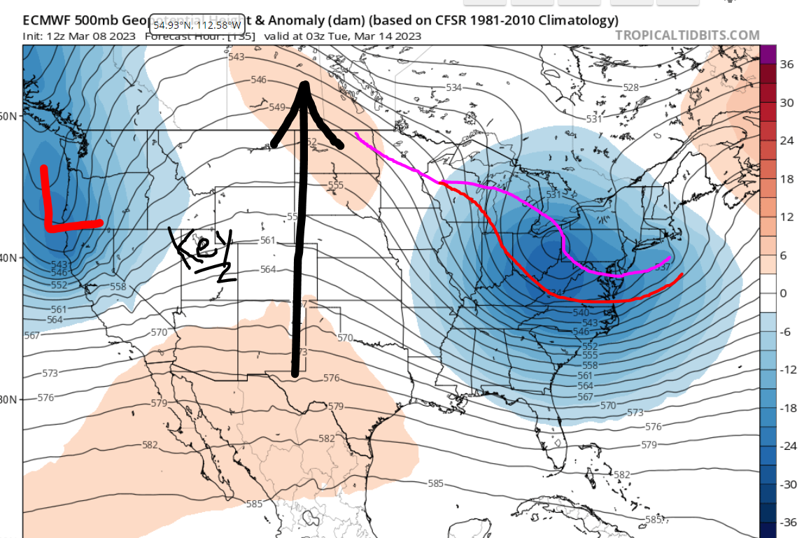
I circled in purple the southern and northern short wave energies that are poised to phase near the east coast. WHERE and WHEN is very important in terms of keeping it cold for snow (or even out to sea like the GFS shows). Heights are rising along the coast (black arrow) and the western ridge is looking kind of defeated. Notice how the heights over Arizona look quite meridional but we're seeing a spike over Idaho. That is not a terrific look, or one that will put the phase where we need it to be.
Here we are Monday evening. The ridge looks a little better but it's already too late. The southern stream is AHEAD of the northern stream. We wanted this phase to happen by now. But the overall flow is a little too quick. Not enough blocking mechanisms to slow the pace down.
Ultimately, the EURO still shows a big storm and brings snowfall to the area. But you have to put some weight on the GFS which shows a low impact event, because if the flow is as fast as it suggests (and I just showed why that is), then it may be onto something.
_________________
_______________________________________________________________________________________________________
CLICK HERE to view NJ Strong Snowstorm Classifications
Frank_Wx- Godzilla Seeker
- Posts : 21305
Reputation : 328
Join date : 2013-01-05
Age : 32
Location : Jersey City, NJ -
SENJsnowman likes this post
Page 4 of 6 • 1, 2, 3, 4, 5, 6 ![]()
|
|
|