2023 Atlantic Tropics season
Page 17 of 20 •  1 ... 10 ... 16, 17, 18, 19, 20
 Re: 2023 Atlantic Tropics season
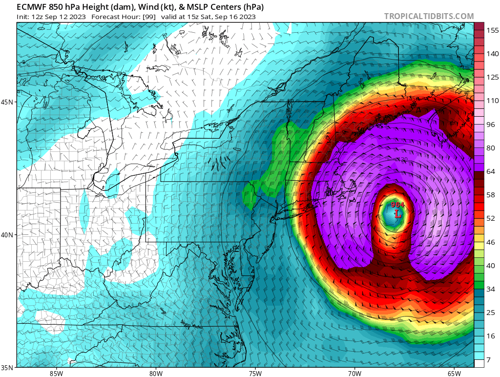
As Levi said he actually slows down when he reaches this area sticking around for about 12 hrs or so.
jmanley32- Senior Enthusiast

- Posts : 20535
Join date : 2013-12-12
 Re: 2023 Atlantic Tropics season
jmanley32 wrote:As I said we are going to have to watch his forward speed once he turns or if he turns later, which would also bring him slightly closer to 70W, he is at about 65W now, which honestly is further west than I thought he would get. But being he looks to hook I don't think thr 70W thing holds anymore, as he heads north he gets pretty close. I have a feeling we won't know until it is kinda too late, luckily and hopefully the intensity will go way down but even TS force winds with the saturated ground and tomorrows flooding potential and full leaves wont take much to make a mess. I think your son will be fine if he listens to you and just hunkers down, as I stated I will be further east towards cape by about 150 miles which will mean a big difference if Lee were to pull the Euro track. Levi's video was really good and spot on, easy to understand. Overall I think we can handle this one even if we were to take a direct hit which isn't going to happen.weatherwatchermom wrote:watching levi's video..omg..how the heck is any official going to make a decision on what emergency services need to be put in place. Gfs models the storm moving faster and therefore missing the major effects on USA and Euro has a different solution..this is nuts.
thanks...yes I think they should be ok. but its just nuts that the models can be so different. that is what is driving me crazy....lol he is all set with everything he needs and my niece right on the water my sister is waiting to hear what the school says..she has her car..which will have to be moved somewhere.lol like I said earlier I was more worried about Snow and cold..cant wait for lee to be out of here!!!
weatherwatchermom- Senior Enthusiast

- Posts : 3793
Join date : 2014-11-25
 Re: 2023 Atlantic Tropics season
Where is he at school again? make sure car is not near any trees if possible.weatherwatchermom wrote:jmanley32 wrote:As I said we are going to have to watch his forward speed once he turns or if he turns later, which would also bring him slightly closer to 70W, he is at about 65W now, which honestly is further west than I thought he would get. But being he looks to hook I don't think thr 70W thing holds anymore, as he heads north he gets pretty close. I have a feeling we won't know until it is kinda too late, luckily and hopefully the intensity will go way down but even TS force winds with the saturated ground and tomorrows flooding potential and full leaves wont take much to make a mess. I think your son will be fine if he listens to you and just hunkers down, as I stated I will be further east towards cape by about 150 miles which will mean a big difference if Lee were to pull the Euro track. Levi's video was really good and spot on, easy to understand. Overall I think we can handle this one even if we were to take a direct hit which isn't going to happen.weatherwatchermom wrote:watching levi's video..omg..how the heck is any official going to make a decision on what emergency services need to be put in place. Gfs models the storm moving faster and therefore missing the major effects on USA and Euro has a different solution..this is nuts.
thanks...yes I think they should be ok. but its just nuts that the models can be so different. that is what is driving me crazy....lol he is all set with everything he needs and my niece right on the water my sister is waiting to hear what the school says..she has her car..which will have to be moved somewhere.lol like I said earlier I was more worried about Snow and cold..cant wait for lee to be out of here!!!
Last edited by jmanley32 on Tue Sep 12, 2023 3:42 pm; edited 1 time in total

jmanley32- Senior Enthusiast

- Posts : 20535
Reputation : 108
Join date : 2013-12-12
Age : 43
Location : Yonkers, NY
 Re: 2023 Atlantic Tropics season



jmanley32- Senior Enthusiast

- Posts : 20535
Reputation : 108
Join date : 2013-12-12
Age : 43
Location : Yonkers, NY
 Re: 2023 Atlantic Tropics season

jmanley32- Senior Enthusiast

- Posts : 20535
Reputation : 108
Join date : 2013-12-12
Age : 43
Location : Yonkers, NY
 Re: 2023 Atlantic Tropics season
He is at Bryant and freshman not allowed cars so we are good with that..lol My niece is at Johnson and wales in Providence and freshman there can have a carjmanley32 wrote:Where is he at school again? make sure car is not near any trees if possible.weatherwatchermom wrote:jmanley32 wrote:As I said we are going to have to watch his forward speed once he turns or if he turns later, which would also bring him slightly closer to 70W, he is at about 65W now, which honestly is further west than I thought he would get. But being he looks to hook I don't think thr 70W thing holds anymore, as he heads north he gets pretty close. I have a feeling we won't know until it is kinda too late, luckily and hopefully the intensity will go way down but even TS force winds with the saturated ground and tomorrows flooding potential and full leaves wont take much to make a mess. I think your son will be fine if he listens to you and just hunkers down, as I stated I will be further east towards cape by about 150 miles which will mean a big difference if Lee were to pull the Euro track. Levi's video was really good and spot on, easy to understand. Overall I think we can handle this one even if we were to take a direct hit which isn't going to happen.weatherwatchermom wrote:watching levi's video..omg..how the heck is any official going to make a decision on what emergency services need to be put in place. Gfs models the storm moving faster and therefore missing the major effects on USA and Euro has a different solution..this is nuts.
thanks...yes I think they should be ok. but its just nuts that the models can be so different. that is what is driving me crazy....lol he is all set with everything he needs and my niece right on the water my sister is waiting to hear what the school says..she has her car..which will have to be moved somewhere.lol like I said earlier I was more worried about Snow and cold..cant wait for lee to be out of here!!!

weatherwatchermom- Senior Enthusiast

- Posts : 3793
Reputation : 78
Join date : 2014-11-25
Location : Hazlet Township, NJ
 Saw this post about Springsteen.The Boss is taking an unexpected breather and postponing his September shows, citing doctors' orders. Bruce Springsteen announced on his website Wednesday that he was postponing shows for the remainder of the month while he
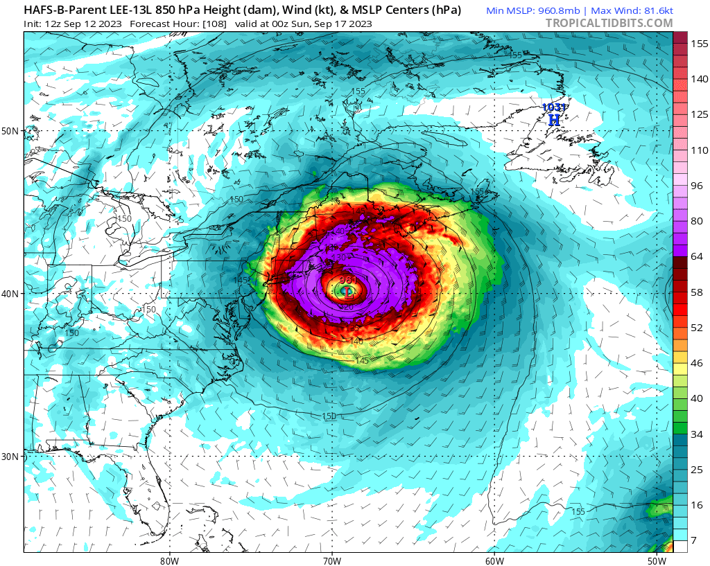
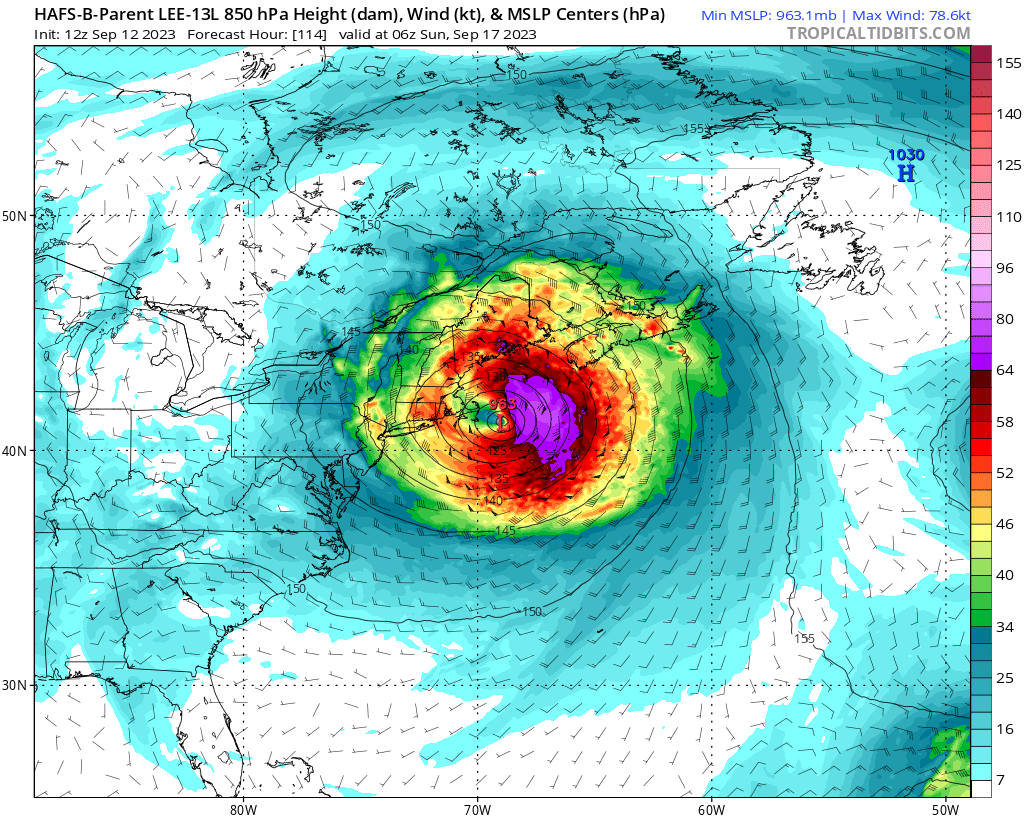
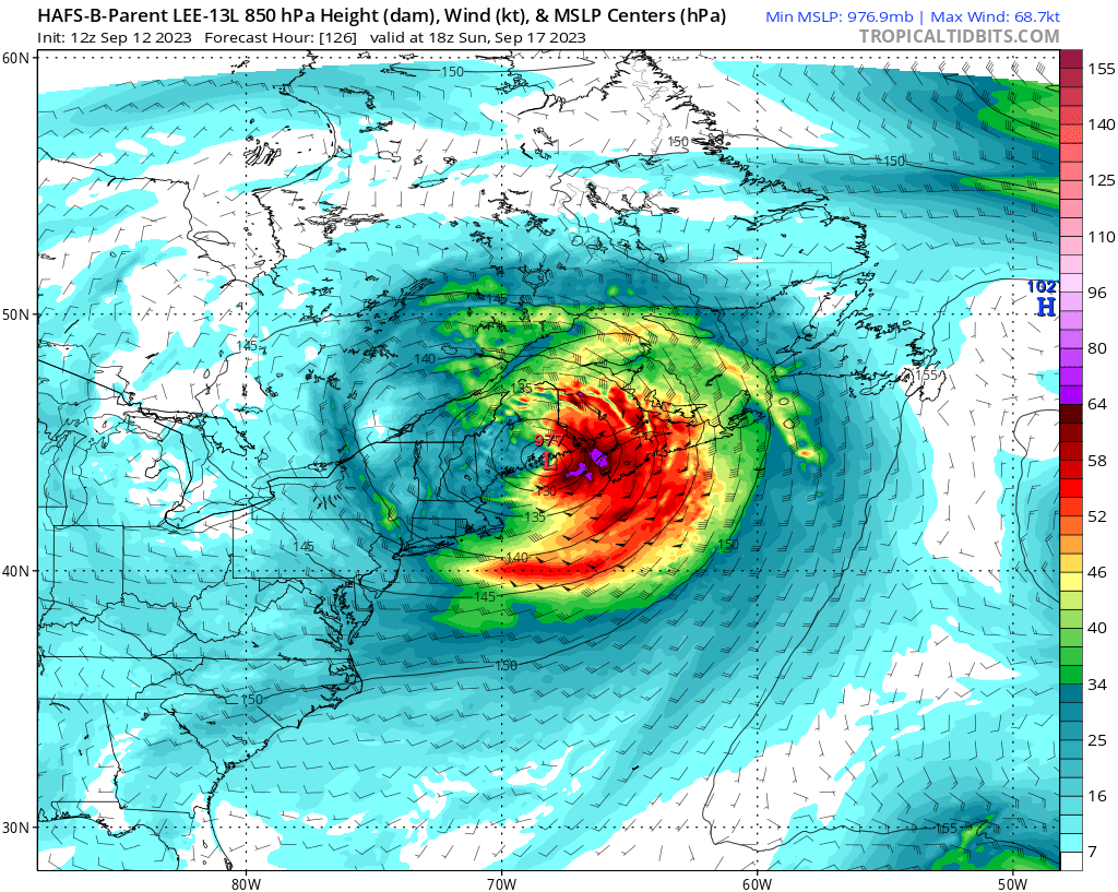
jmanley32 wrote:My god the HAFS-B has a even more insane wind field reaches into Hudson valley at one point and he slows down to dirt slow (yes I realize these are 850mb winds so knock them down by 10-15mph however they are in kts so first calculate that math, and these are sustained so gusts 15-20mph higher are possible). I don't know if I should be driving back on Saturday from CT/RI border, what do you guys think, I could stay at my parents in Guilford, CT which is about 30 miles more west. Our hotel stay is only till Sat 11am and unless the concert at the casino is canceled Sat night I won't be able to extend my stay, even then they may still be booked (Bruce Springsteen). Tell you what though; being up in a 30 story casino will be interesting if we do get hit over there, I have been there in strong t-storms and the windows vibrate, kind of scary. It appears Sat morning and midday will be the worst of it. And I bet my friends flight gets delayed or canceled if the western track occurs.
Frozen.9- Posts : 25
Reputation : 0
Join date : 2021-02-06
 Re: 2023 Atlantic Tropics season
interesting thanks for letting me know. I wasnt going to the show but now maybe rooms are availsble for sat night.Frozen.9 wrote:jmanley32 wrote:My god the HAFS-B has a even more insane wind field reaches into Hudson valley at one point and he slows down to dirt slow (yes I realize these are 850mb winds so knock them down by 10-15mph however they are in kts so first calculate that math, and these are sustained so gusts 15-20mph higher are possible). I don't know if I should be driving back on Saturday from CT/RI border, what do you guys think, I could stay at my parents in Guilford, CT which is about 30 miles more west. Our hotel stay is only till Sat 11am and unless the concert at the casino is canceled Sat night I won't be able to extend my stay, even then they may still be booked (Bruce Springsteen). Tell you what though; being up in a 30 story casino will be interesting if we do get hit over there, I have been there in strong t-storms and the windows vibrate, kind of scary. It appears Sat morning and midday will be the worst of it. And I bet my friends flight gets delayed or canceled if the western track occurs.

jmanley32- Senior Enthusiast

- Posts : 20535
Reputation : 108
Join date : 2013-12-12
Age : 43
Location : Yonkers, NY
 Re: 2023 Atlantic Tropics season
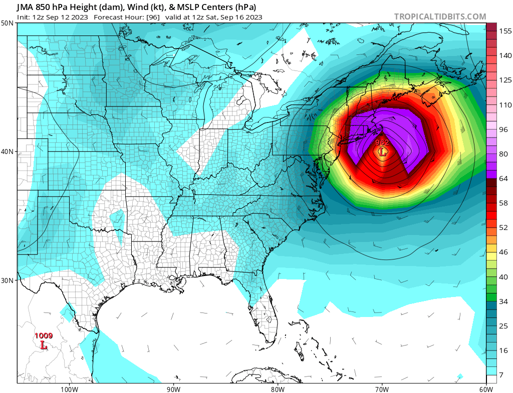
Looks like a upside down pac-man eating a dot lol, not sure what's up with the odd shape of the wind field in purple.

jmanley32- Senior Enthusiast

- Posts : 20535
Reputation : 108
Join date : 2013-12-12
Age : 43
Location : Yonkers, NY
 Re: 2023 Atlantic Tropics season
LEE'S LARGE WINDFIELD A WEEKEND CONCERN INTO NEW ENGLAND..#HurricaneLee will go through a transitional phase towards extratropical (the look of a large nor'easter) by Friday. As this happens the wind field will double in size by Sat AM which you see in the European model below.… pic.twitter.com/s6QTLlNaSM
— Mike Masco (@MikeMasco) September 12, 2023
_________________
Mugs
AKA:King: Snow Weenie
Self Proclaimed
WINTER 2014-15 : 55.12" +.02 for 6 coatings (avg. 35")
WINTER 2015-16 Total - 29.8" (Avg 35")
WINTER 2016-17 : 39.5" so far

amugs- Advanced Forecaster - Mod

- Posts : 15095
Reputation : 213
Join date : 2013-01-07
Age : 54
Location : Hillsdale,NJ
 Re: 2023 Atlantic Tropics season
One note of caution re: Lee's eventual track. Tropical cyclones that are at least partially captured by a neg tilt upper trough/cutoff low and whose typical recurve was blocked by a blocking high tend to end up west of forecasts at this range (4-5 days out).
— Yaakov Cantor (@yconsor) September 12, 2023
Here are four examples: Fiona in 2022, Henri in 2021, Isaias in 2020, Florence in 2018 all ended up bending to the left more than forecast, ranging from 100 km to several hundred km west of NHC forecasts 4-5 days out. Actual tracks in pink pic.twitter.com/yXoJrUCzRH
— Yaakov Cantor (@yconsor) September 12, 2023
Here are GEFS runs around the same time. Similar eastward bias is noted pic.twitter.com/bDEGHCbMbp
— Yaakov Cantor (@yconsor) September 12, 2023
_________________
Mugs
AKA:King: Snow Weenie
Self Proclaimed
WINTER 2014-15 : 55.12" +.02 for 6 coatings (avg. 35")
WINTER 2015-16 Total - 29.8" (Avg 35")
WINTER 2016-17 : 39.5" so far

amugs- Advanced Forecaster - Mod

- Posts : 15095
Reputation : 213
Join date : 2013-01-07
Age : 54
Location : Hillsdale,NJ
 Re: 2023 Atlantic Tropics season
Really interesting and I wanted to see something like this, wish they had sandy because I think same thing, the cone at one point was north oe NNE.See I say it ain't over till it's over, still a lot of time for changes, how fast or slow is he in his turn and then forward speed, currently still crawling, how big does the wind field actually get, what is his actual intensity on approach?amugs wrote:This is tremendously interesting and evidentiary backed . Amazing, JMA and Euro are onto something from this analysis.One note of caution re: Lee's eventual track. Tropical cyclones that are at least partially captured by a neg tilt upper trough/cutoff low and whose typical recurve was blocked by a blocking high tend to end up west of forecasts at this range (4-5 days out).
— Yaakov Cantor (@yconsor) September 12, 2023Here are four examples: Fiona in 2022, Henri in 2021, Isaias in 2020, Florence in 2018 all ended up bending to the left more than forecast, ranging from 100 km to several hundred km west of NHC forecasts 4-5 days out. Actual tracks in pink pic.twitter.com/yXoJrUCzRH
— Yaakov Cantor (@yconsor) September 12, 2023Here are GEFS runs around the same time. Similar eastward bias is noted pic.twitter.com/bDEGHCbMbp
— Yaakov Cantor (@yconsor) September 12, 2023

jmanley32- Senior Enthusiast

- Posts : 20535
Reputation : 108
Join date : 2013-12-12
Age : 43
Location : Yonkers, NY
 Re: 2023 Atlantic Tropics season
jmanley32 wrote:Really interesting and I wanted to see something like this, wish they had sandy because I think same thing, the cone at one point was north oe NNE.See I say it ain't over till it's over, still a lot of time for changes, how fast or slow is he in his turn and then forward speed, currently still crawling, how big does the wind field actually get, what is his actual intensity on approach?amugs wrote:This is tremendously interesting and evidentiary backed . Amazing, JMA and Euro are onto something from this analysis.One note of caution re: Lee's eventual track. Tropical cyclones that are at least partially captured by a neg tilt upper trough/cutoff low and whose typical recurve was blocked by a blocking high tend to end up west of forecasts at this range (4-5 days out).
— Yaakov Cantor (@yconsor) September 12, 2023Here are four examples: Fiona in 2022, Henri in 2021, Isaias in 2020, Florence in 2018 all ended up bending to the left more than forecast, ranging from 100 km to several hundred km west of NHC forecasts 4-5 days out. Actual tracks in pink pic.twitter.com/yXoJrUCzRH
— Yaakov Cantor (@yconsor) September 12, 2023Here are GEFS runs around the same time. Similar eastward bias is noted pic.twitter.com/bDEGHCbMbp
— Yaakov Cantor (@yconsor) September 12, 2023
About 250 mile in Diameter of tropical force winds
_________________
Mugs
AKA:King: Snow Weenie
Self Proclaimed
WINTER 2014-15 : 55.12" +.02 for 6 coatings (avg. 35")
WINTER 2015-16 Total - 29.8" (Avg 35")
WINTER 2016-17 : 39.5" so far

amugs- Advanced Forecaster - Mod

- Posts : 15095
Reputation : 213
Join date : 2013-01-07
Age : 54
Location : Hillsdale,NJ
 Re: 2023 Atlantic Tropics season
Oh those were not actual questions, they were what I was saying will effect impacts.amugs wrote:jmanley32 wrote:Really interesting and I wanted to see something like this, wish they had sandy because I think same thing, the cone at one point was north oe NNE.See I say it ain't over till it's over, still a lot of time for changes, how fast or slow is he in his turn and then forward speed, currently still crawling, how big does the wind field actually get, what is his actual intensity on approach?amugs wrote:This is tremendously interesting and evidentiary backed . Amazing, JMA and Euro are onto something from this analysis.One note of caution re: Lee's eventual track. Tropical cyclones that are at least partially captured by a neg tilt upper trough/cutoff low and whose typical recurve was blocked by a blocking high tend to end up west of forecasts at this range (4-5 days out).
— Yaakov Cantor (@yconsor) September 12, 2023Here are four examples: Fiona in 2022, Henri in 2021, Isaias in 2020, Florence in 2018 all ended up bending to the left more than forecast, ranging from 100 km to several hundred km west of NHC forecasts 4-5 days out. Actual tracks in pink pic.twitter.com/yXoJrUCzRH
— Yaakov Cantor (@yconsor) September 12, 2023Here are GEFS runs around the same time. Similar eastward bias is noted pic.twitter.com/bDEGHCbMbp
— Yaakov Cantor (@yconsor) September 12, 2023
About 250 mile in Diameter of tropical force winds
Thats the windfield size now isn't it? Or is that the progged size? Not nearly as big as Sandy then.

jmanley32- Senior Enthusiast

- Posts : 20535
Reputation : 108
Join date : 2013-12-12
Age : 43
Location : Yonkers, NY
 Re: 2023 Atlantic Tropics season
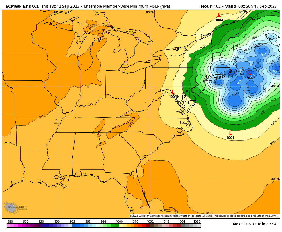
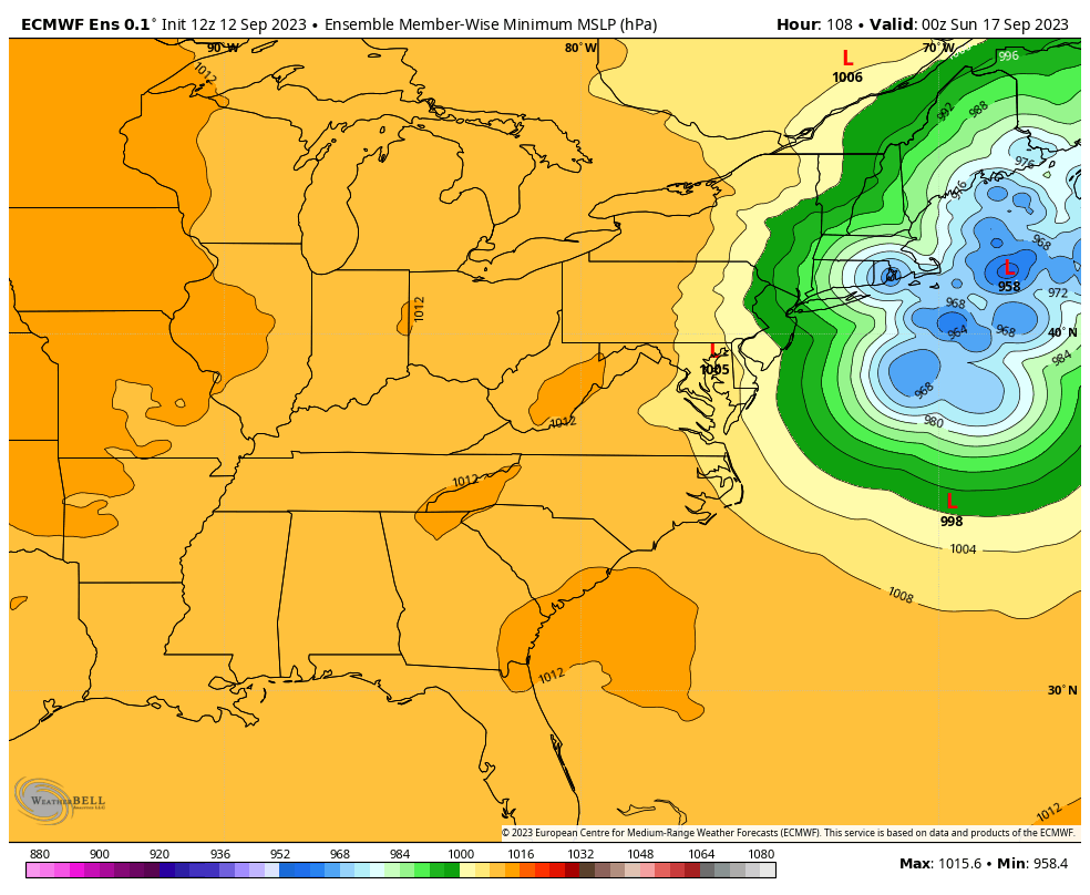
Euro 18z ensembles big shift west some lows as can be seen hit in LI and CT. Some are slower but most are around cape cod or further west now, ruh roh. Wind gust map too.
18z
12z
Wind gusts 18z

High surf advisory up for LI, and Queens with 7-10 ft waves on Thursday, wow

jmanley32- Senior Enthusiast

- Posts : 20535
Reputation : 108
Join date : 2013-12-12
Age : 43
Location : Yonkers, NY
 Re: 2023 Atlantic Tropics season
1. Try to kick Lee northward
2. Amplify the downstream flow, thereby further aiding in ridge development northeast of Lee
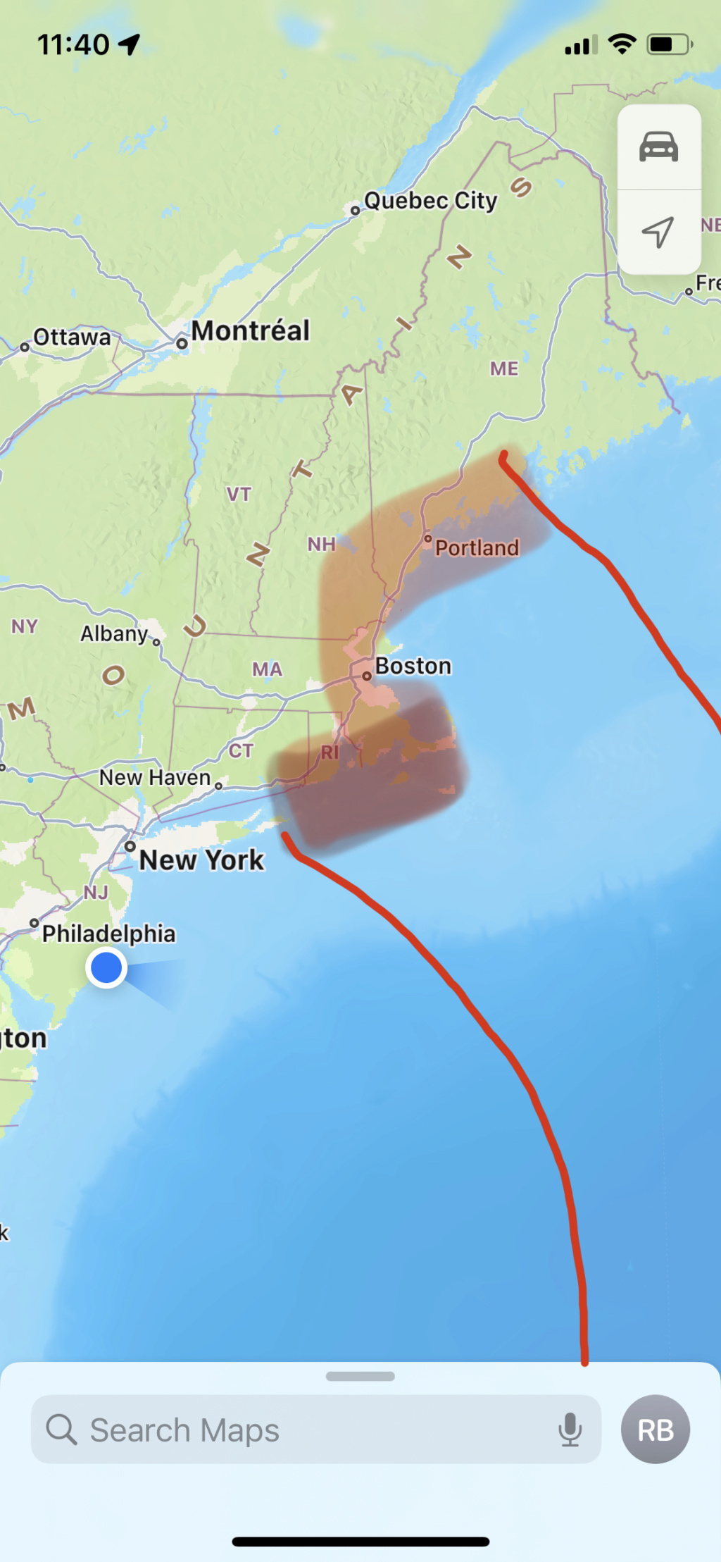
I truthfully do not see New England escaping without an official landfall, and I like the zone from Block Island to Rockland, Maine as the zone of landfall. Statistically, I’d say Cape Cod has the highest probability, BUT, personally, I think the region between Block Island and Cape Cod is more likely based on my analysis.
rb924119- Meteorologist

- Posts : 6928
Reputation : 194
Join date : 2013-02-06
Age : 32
Location : Greentown, Pa
 Re: 2023 Atlantic Tropics season
rb924119 wrote:Sorry, gang, I’ve been super busy the last two days working, prepping to get back to my regular job, and then getting back to Jersey between yesterday and today. I have no changes to my thinking. I think the hurricane models, GFS, and GEM suites are too progressive here and are not adequately representing the effect of the ridging to the northeast of the storm as it approaches. In my opinion, the EURO suite is much more aligned with my thinking, and I’m still on the western periphery of that. The pattern supports the idea of separation between the initial trough lifting out of the Northeast and Lee by way of relatively increased heights. It also supports enhanced ridging rapidly blossoming to the northeast of Lee due to factors previously mentioned in earlier posts. The trough diving into the central CONUS adds complexity, as well, since the it will likely act to do two things:
1. Try to kick Lee northward
2. Amplify the downstream flow, thereby further aiding in ridge development northeast of Lee
I truthfully do not see New England escaping without an official landfall, and I like the zone from Block Island to Rockland, Maine as the zone of landfall. Statistically, I’d say Cape Cod has the highest probability, BUT, personally, I think the region between Block Island and Cape Cod is more likely based on my analysis.
rb924119- Meteorologist

- Posts : 6928
Reputation : 194
Join date : 2013-02-06
Age : 32
Location : Greentown, Pa
 Re: 2023 Atlantic Tropics season
rb924119- Meteorologist

- Posts : 6928
Reputation : 194
Join date : 2013-02-06
Age : 32
Location : Greentown, Pa
 Re: 2023 Atlantic Tropics season
rb924119 wrote:rb924119 wrote:Sorry, gang, I’ve been super busy the last two days working, prepping to get back to my regular job, and then getting back to Jersey between yesterday and today. I have no changes to my thinking. I think the hurricane models, GFS, and GEM suites are too progressive here and are not adequately representing the effect of the ridging to the northeast of the storm as it approaches. In my opinion, the EURO suite is much more aligned with my thinking, and I’m still on the western periphery of that. The pattern supports the idea of separation between the initial trough lifting out of the Northeast and Lee by way of relatively increased heights. It also supports enhanced ridging rapidly blossoming to the northeast of Lee due to factors previously mentioned in earlier posts. The trough diving into the central CONUS adds complexity, as well, since the it will likely act to do two things:
1. Try to kick Lee northward
2. Amplify the downstream flow, thereby further aiding in ridge development northeast of Lee
I truthfully do not see New England escaping without an official landfall, and I like the zone from Block Island to Rockland, Maine as the zone of landfall. Statistically, I’d say Cape Cod has the highest probability, BUT, personally, I think the region between Block Island and Cape Cod is more likely based on my analysis.

weatherwatchermom- Senior Enthusiast

- Posts : 3793
Reputation : 78
Join date : 2014-11-25
Location : Hazlet Township, NJ
rb924119 likes this post
 Re: 2023 Atlantic Tropics season
rb924119- Meteorologist

- Posts : 6928
Reputation : 194
Join date : 2013-02-06
Age : 32
Location : Greentown, Pa
 Re: 2023 Atlantic Tropics season
weatherwatchermom wrote:rb924119 wrote:rb924119 wrote:Sorry, gang, I’ve been super busy the last two days working, prepping to get back to my regular job, and then getting back to Jersey between yesterday and today. I have no changes to my thinking. I think the hurricane models, GFS, and GEM suites are too progressive here and are not adequately representing the effect of the ridging to the northeast of the storm as it approaches. In my opinion, the EURO suite is much more aligned with my thinking, and I’m still on the western periphery of that. The pattern supports the idea of separation between the initial trough lifting out of the Northeast and Lee by way of relatively increased heights. It also supports enhanced ridging rapidly blossoming to the northeast of Lee due to factors previously mentioned in earlier posts. The trough diving into the central CONUS adds complexity, as well, since the it will likely act to do two things:
1. Try to kick Lee northward
2. Amplify the downstream flow, thereby further aiding in ridge development northeast of Lee
I truthfully do not see New England escaping without an official landfall, and I like the zone from Block Island to Rockland, Maine as the zone of landfall. Statistically, I’d say Cape Cod has the highest probability, BUT, personally, I think the region between Block Island and Cape Cod is more likely based on my analysis.when will we have a better idea?? Thank you for your analysis
No problem, Mom
rb924119- Meteorologist

- Posts : 6928
Reputation : 194
Join date : 2013-02-06
Age : 32
Location : Greentown, Pa
 Re: 2023 Atlantic Tropics season
Thanks for your update, yeah all the over night models even a few of the hurricane models came further west. The HAFS B now have moderate TS force winds into western, CT and parts of far western, NY at one point. NHC notes that the actual landfall will have little to no significance to impacts due to the shear size of the expanding windfield. NHC also has Lee slower which is what would favor a more western track and even the cone shifted slightly to the west but likely not enough, you have been pretty good with this, though your bulls eye area has continued to shift east haha, its still within your area call which was a good one. IMO it landfalls on the further western areas you marked, if not cape cod even further like a RI landfall. Which puts me in a precarious spot being in far eastern, CT from thursday afternoon to saturday afternoon (but I was able to securely another night at the hotel complimentary should I decide to stay). What do you think are the odds the impacts are enough to impact bradley airport in Windsor Locks CT? My friend is leaving out Sat at 3pm, my thinking is due to the size and that being about 100 miles east and 40 miles north of here that it will likely be delayed if not canceled until Sunday. Would be nice to hangout with him for another night.rb924119 wrote:Sorry, gang, I’ve been super busy the last two days working, prepping to get back to my regular job, and then getting back to Jersey between yesterday and today. I have no changes to my thinking. I think the hurricane models, GFS, and GEM suites are too progressive here and are not adequately representing the effect of the ridging to the northeast of the storm as it approaches. In my opinion, the EURO suite is much more aligned with my thinking, and I’m still on the western periphery of that. The pattern supports the idea of separation between the initial trough lifting out of the Northeast and Lee by way of relatively increased heights. It also supports enhanced ridging rapidly blossoming to the northeast of Lee due to factors previously mentioned in earlier posts. The trough diving into the central CONUS adds complexity, as well, since the it will likely act to do two things:
1. Try to kick Lee northward
2. Amplify the downstream flow, thereby further aiding in ridge development northeast of Lee
I truthfully do not see New England escaping without an official landfall, and I like the zone from Block Island to Rockland, Maine as the zone of landfall. Statistically, I’d say Cape Cod has the highest probability, BUT, personally, I think the region between Block Island and Cape Cod is more likely based on my analysis.
If you were to guess when would hurricane/TS watches go up and how far west would they reach lets say if a RI landfall happened, or lets be safe a cape cod landfall.

jmanley32- Senior Enthusiast

- Posts : 20535
Reputation : 108
Join date : 2013-12-12
Age : 43
Location : Yonkers, NY
 Re: 2023 Atlantic Tropics season
They did from what I can see.rb924119 wrote:Same story with the GEM, though maybe only about 70-80 miles. Still, gives my ideas merit as the changes are exactly what were mentioned - more separation between Lee and the departing Northeastern U.S. trough, increased heights to the northeast of Lee, and more influence from incoming Midwestern trough. I expect the respective ensembles to follow suit.

jmanley32- Senior Enthusiast

- Posts : 20535
Reputation : 108
Join date : 2013-12-12
Age : 43
Location : Yonkers, NY
 Re: 2023 Atlantic Tropics season
With all the technology today and weather forecasting stuff we won't know for sure until less than 24 hrs out?! This is a hurricane not a snowstorm, yeah snowstorms are impactful but they used to be better with hurricanes. This one especially since it really wont matter too much where the landfall is if in block island we are in play for TS conditions. If so I will be in the hurricane conditions (where I will be (Mohegan Sun) is 35 miles birds eye from Block Island, which should be interesting in a 36 story hotel....rb924119 wrote:weatherwatchermom wrote:rb924119 wrote:rb924119 wrote:Sorry, gang, I’ve been super busy the last two days working, prepping to get back to my regular job, and then getting back to Jersey between yesterday and today. I have no changes to my thinking. I think the hurricane models, GFS, and GEM suites are too progressive here and are not adequately representing the effect of the ridging to the northeast of the storm as it approaches. In my opinion, the EURO suite is much more aligned with my thinking, and I’m still on the western periphery of that. The pattern supports the idea of separation between the initial trough lifting out of the Northeast and Lee by way of relatively increased heights. It also supports enhanced ridging rapidly blossoming to the northeast of Lee due to factors previously mentioned in earlier posts. The trough diving into the central CONUS adds complexity, as well, since the it will likely act to do two things:
1. Try to kick Lee northward
2. Amplify the downstream flow, thereby further aiding in ridge development northeast of Lee
I truthfully do not see New England escaping without an official landfall, and I like the zone from Block Island to Rockland, Maine as the zone of landfall. Statistically, I’d say Cape Cod has the highest probability, BUT, personally, I think the region between Block Island and Cape Cod is more likely based on my analysis.when will we have a better idea?? Thank you for your analysis
No problem, MomI feel pretty confident personally. But with respect to the models/NHC, probably not for another day or two. The NHC will hug the hurricane models, which will likely be the last to adjust, so expect only incremental changes from them in successive updates (assuming the changes I discussed hold true). The regular models (GEM/GFS and to a lesser extent, the EURO suites) are likely coming around now, and should be pretty good by Thursday night’s runs, in my opinion. I’d think no later than Friday’s 12z suites. After that, I wouldn’t expect too many “surprises”. Just my opinion though.

jmanley32- Senior Enthusiast

- Posts : 20535
Reputation : 108
Join date : 2013-12-12
Age : 43
Location : Yonkers, NY
 Re: 2023 Atlantic Tropics season
jmanley32 wrote:Thanks for your update, yeah all the over night models even a few of the hurricane models came further west. The HAFS B now have moderate TS force winds into western, CT and parts of far western, NY at one point. NHC notes that the actual landfall will have little to no significance to impacts due to the shear size of the expanding windfield. NHC also has Lee slower which is what would favor a more western track and even the cone shifted slightly to the west but likely not enough, you have been pretty good with this, though your bulls eye area has continued to shift east haha, its still within your area call which was a good one. IMO it landfalls on the further western areas you marked, if not cape cod even further like a RI landfall. Which puts me in a precarious spot being in far eastern, CT from thursday afternoon to saturday afternoon (but I was able to securely another night at the hotel complimentary should I decide to stay). What do you think are the odds the impacts are enough to impact bradley airport in Windsor Locks CT? My friend is leaving out Sat at 3pm, my thinking is due to the size and that being about 100 miles east and 40 miles north of here that it will likely be delayed if not canceled until Sunday. Would be nice to hangout with him for another night.rb924119 wrote:Sorry, gang, I’ve been super busy the last two days working, prepping to get back to my regular job, and then getting back to Jersey between yesterday and today. I have no changes to my thinking. I think the hurricane models, GFS, and GEM suites are too progressive here and are not adequately representing the effect of the ridging to the northeast of the storm as it approaches. In my opinion, the EURO suite is much more aligned with my thinking, and I’m still on the western periphery of that. The pattern supports the idea of separation between the initial trough lifting out of the Northeast and Lee by way of relatively increased heights. It also supports enhanced ridging rapidly blossoming to the northeast of Lee due to factors previously mentioned in earlier posts. The trough diving into the central CONUS adds complexity, as well, since the it will likely act to do two things:
1. Try to kick Lee northward
2. Amplify the downstream flow, thereby further aiding in ridge development northeast of Lee
I truthfully do not see New England escaping without an official landfall, and I like the zone from Block Island to Rockland, Maine as the zone of landfall. Statistically, I’d say Cape Cod has the highest probability, BUT, personally, I think the region between Block Island and Cape Cod is more likely based on my analysis.
If you were to guess when would hurricane/TS watches go up and how far west would they reach lets say if a RI landfall happened, or lets be safe a cape cod landfall.
Regarding the bolded text, that’s not entirely true. The three zones I outlined since the beginning have been the following:
1. North/South Carolina border to Maine
2. Coastal Virginia to Cape Cod, specifically mentioned center point of my cone would be somewhere on Lomg Island
3. Block Island to Cape Cod, with my zone of expected landfall between block island and Cape Cod.
Considering that the centerline of my forecast zone even in the first one was Long Island, my forecast “track” (in quotes because technically I never issued a map) has only shifted east one time in the span of what, two weeks? And that shift was only by about 100 miles? I’d say that’s pretty darn consistent. The only thing that has changed is my zones got narrower and more refined as the specific components have become clearer, but the idea and center points of my three different zones have remained very consistent.
rb924119- Meteorologist

- Posts : 6928
Reputation : 194
Join date : 2013-02-06
Age : 32
Location : Greentown, Pa
amugs likes this post
 Re: 2023 Atlantic Tropics season
jmanley32 wrote:Thanks for your update, yeah all the over night models even a few of the hurricane models came further west. The HAFS B now have moderate TS force winds into western, CT and parts of far western, NY at one point. NHC notes that the actual landfall will have little to no significance to impacts due to the shear size of the expanding windfield. NHC also has Lee slower which is what would favor a more western track and even the cone shifted slightly to the west but likely not enough, you have been pretty good with this, though your bulls eye area has continued to shift east haha, its still within your area call which was a good one. IMO it landfalls on the further western areas you marked, if not cape cod even further like a RI landfall. Which puts me in a precarious spot being in far eastern, CT from thursday afternoon to saturday afternoon (but I was able to securely another night at the hotel complimentary should I decide to stay). What do you think are the odds the impacts are enough to impact bradley airport in Windsor Locks CT? My friend is leaving out Sat at 3pm, my thinking is due to the size and that being about 100 miles east and 40 miles north of here that it will likely be delayed if not canceled until Sunday. Would be nice to hangout with him for another night.rb924119 wrote:Sorry, gang, I’ve been super busy the last two days working, prepping to get back to my regular job, and then getting back to Jersey between yesterday and today. I have no changes to my thinking. I think the hurricane models, GFS, and GEM suites are too progressive here and are not adequately representing the effect of the ridging to the northeast of the storm as it approaches. In my opinion, the EURO suite is much more aligned with my thinking, and I’m still on the western periphery of that. The pattern supports the idea of separation between the initial trough lifting out of the Northeast and Lee by way of relatively increased heights. It also supports enhanced ridging rapidly blossoming to the northeast of Lee due to factors previously mentioned in earlier posts. The trough diving into the central CONUS adds complexity, as well, since the it will likely act to do two things:
1. Try to kick Lee northward
2. Amplify the downstream flow, thereby further aiding in ridge development northeast of Lee
I truthfully do not see New England escaping without an official landfall, and I like the zone from Block Island to Rockland, Maine as the zone of landfall. Statistically, I’d say Cape Cod has the highest probability, BUT, personally, I think the region between Block Island and Cape Cod is more likely based on my analysis.
If you were to guess when would hurricane/TS watches go up and how far west would they reach lets say if a RI landfall happened, or lets be safe a cape cod landfall.
If my idea is correct, and we see landfall further west (which I agree with you), I’d expect the flight to be cancelled. If it goes east of Cape Cod, probably just delayed. As I told Mom earlier, the NHC is going to hug the hurricane models, so until they come on board (if they do), I don’t expect the official advisories to be hoisted. Maybe wind advisories to start that then get changed. I’d hope that by tomorrow evening things are more in alignment and proper actions are taken.
rb924119- Meteorologist

- Posts : 6928
Reputation : 194
Join date : 2013-02-06
Age : 32
Location : Greentown, Pa
 Re: 2023 Atlantic Tropics season
jmanley32 wrote:With all the technology today and weather forecasting stuff we won't know for sure until less than 24 hrs out?! This is a hurricane not a snowstorm, yeah snowstorms are impactful but they used to be better with hurricanes. This one especially since it really wont matter too much where the landfall is if in block island we are in play for TS conditions. If so I will be in the hurricane conditions (where I will be (Mohegan Sun) is 35 miles birds eye from Block Island, which should be interesting in a 36 story hotel....rb924119 wrote:weatherwatchermom wrote:rb924119 wrote:rb924119 wrote:Sorry, gang, I’ve been super busy the last two days working, prepping to get back to my regular job, and then getting back to Jersey between yesterday and today. I have no changes to my thinking. I think the hurricane models, GFS, and GEM suites are too progressive here and are not adequately representing the effect of the ridging to the northeast of the storm as it approaches. In my opinion, the EURO suite is much more aligned with my thinking, and I’m still on the western periphery of that. The pattern supports the idea of separation between the initial trough lifting out of the Northeast and Lee by way of relatively increased heights. It also supports enhanced ridging rapidly blossoming to the northeast of Lee due to factors previously mentioned in earlier posts. The trough diving into the central CONUS adds complexity, as well, since the it will likely act to do two things:
1. Try to kick Lee northward
2. Amplify the downstream flow, thereby further aiding in ridge development northeast of Lee
I truthfully do not see New England escaping without an official landfall, and I like the zone from Block Island to Rockland, Maine as the zone of landfall. Statistically, I’d say Cape Cod has the highest probability, BUT, personally, I think the region between Block Island and Cape Cod is more likely based on my analysis.when will we have a better idea?? Thank you for your analysis
No problem, MomI feel pretty confident personally. But with respect to the models/NHC, probably not for another day or two. The NHC will hug the hurricane models, which will likely be the last to adjust, so expect only incremental changes from them in successive updates (assuming the changes I discussed hold true). The regular models (GEM/GFS and to a lesser extent, the EURO suites) are likely coming around now, and should be pretty good by Thursday night’s runs, in my opinion. I’d think no later than Friday’s 12z suites. After that, I wouldn’t expect too many “surprises”. Just my opinion though.
Well, for reference, you’re roughly 72 hours out now and the spread is still from Nova Scotia to Block Island (between the hurricane models and dynamic models), which is huge, and agreeably disappointing. But with respect to modeling, yeah, we will probably have to wait until we are inside of 36 hours before there’s a good consensus.
rb924119- Meteorologist

- Posts : 6928
Reputation : 194
Join date : 2013-02-06
Age : 32
Location : Greentown, Pa
Page 17 of 20 •  1 ... 10 ... 16, 17, 18, 19, 20
|
|
|

 Home
Home