
 Search
Long Range Thread 27.0
Page 6 of 40 •  1 ... 5, 6, 7 ... 23 ... 40
 ![]()
Re: Long Range Thread 27.0
![]() by aiannone Thu Nov 30, 2023 9:37 am
by aiannone Thu Nov 30, 2023 9:37 am

aiannone- Senior Enthusiast - Mod

- Posts : 4822
Join date : 2013-01-07
sroc4 and amugs like this post
Re: Long Range Thread 27.0
![]() by amugs Thu Nov 30, 2023 12:12 pm
by amugs Thu Nov 30, 2023 12:12 pm
BSR = Bearing Sea Rule
How the Bering Sea Rule Teleconnection [+~19 days, sweet spot Mid-West through North East region] sees the December 13 through 19 period. pic.twitter.com/aVLUnZiozI
— ContentWeatherGuy (@ContentWxGuy) November 29, 2023
amugs- Advanced Forecaster - Mod
- Posts : 15130
Join date : 2013-01-07
Re: Long Range Thread 27.0
![]() by sroc4 Thu Nov 30, 2023 9:04 pm
by sroc4 Thu Nov 30, 2023 9:04 pm


_________________
"In weather and in life, there's no winning and losing; there's only winning and learning."
WINTER 2012/2013 TOTALS 43.65"WINTER 2017/2018 TOTALS 62.85" WINTER 2022/2023 TOTALS 4.9"
WINTER 2013/2014 TOTALS 64.85"WINTER 2018/2019 TOTALS 14.25" WINTER 2023/2024 TOTALS 13.1"
WINTER 2014/2015 TOTALS 71.20"WINTER 2019/2020 TOTALS 6.35"
WINTER 2015/2016 TOTALS 35.00"WINTER 2020/2021 TOTALS 37.75"
WINTER 2016/2017 TOTALS 42.25"WINTER 2021/2022 TOTALS 31.65"

sroc4- Admin

- Posts : 8441
Reputation : 302
Join date : 2013-01-07
Location : Wading River, LI
Re: Long Range Thread 27.0
![]() by MattyICE Thu Nov 30, 2023 10:02 pm
by MattyICE Thu Nov 30, 2023 10:02 pm
sroc4 wrote:We’ll hate to be the bearer of bad news but MJO went from diving into the COD after phase three to now gaining amplitude into phase 4-5-6. This is not good.
Seems to move relatively quickly, though, no?
MattyICE- Advanced Forecaster

- Posts : 249
Reputation : 6
Join date : 2017-11-10
Age : 39
Location : Clifton, NJ (Eastern Passaic County)
Re: Long Range Thread 27.0
![]() by sroc4 Fri Dec 01, 2023 6:42 am
by sroc4 Fri Dec 01, 2023 6:42 am
MattyICE wrote:sroc4 wrote:We’ll hate to be the bearer of bad news but MJO went from diving into the COD after phase three to now gaining amplitude into phase 4-5-6. This is not good.
Seems to move relatively quickly, though, no?
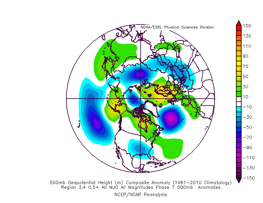
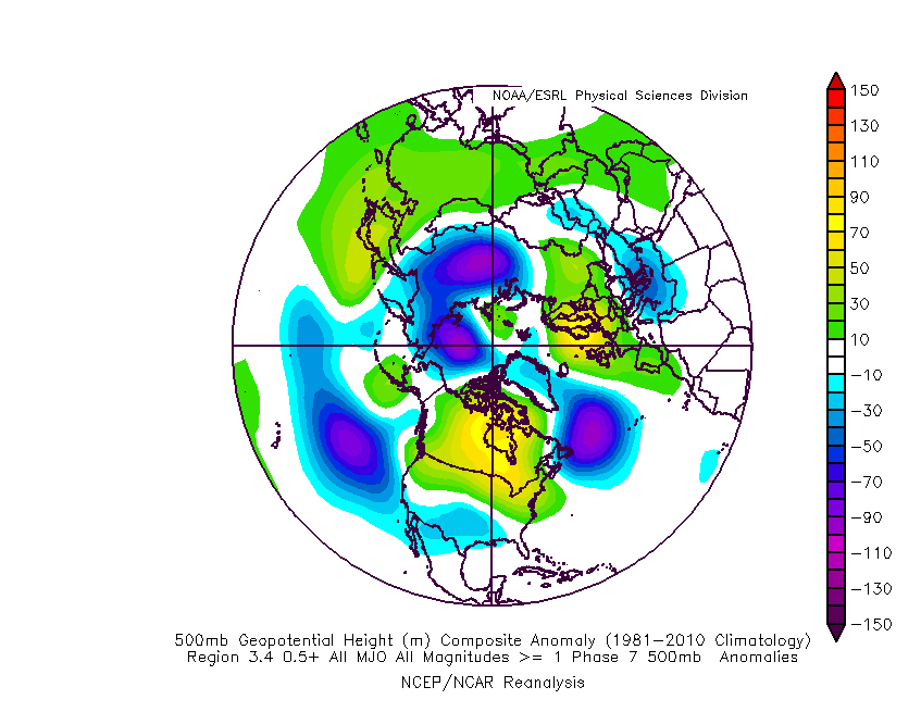
I guess, but if true the next two weeks we go back to almost no chances for white. And then what does the MJO wave do? Does it collapse, or go into phase 7? Because honestly phase 7 in December during El Nino years is not necessarily a cold phase. Below is the 500mb composite for all MJO phase 7 El Nino years, followed by December El Nino years with MJO phase 7 with amplitude > 1. Low amplitude Phase 7 in Dec isn't an all out torch, but it isn't cold, but with amplitude it is pretty warm.
So if it in fact makes it into 7 our chances for cold and white extend out even further. Now truth be told this kind of warm mid month was expected, so I am not overly discouraged for the long haul...yet. What I DO NOT want to start seeing show up in the MJO forcasting is a trip through the 3-6 phases followed by a crash into the center and a re-emergence back again through the same phases. Thus far this fall we have seen the opposite where the re-emergence has been through phases 7-3. If the latter conts for the winter we will be fine, but if we start to see the former come to fruition prepare the bridges.
_________________
"In weather and in life, there's no winning and losing; there's only winning and learning."
WINTER 2012/2013 TOTALS 43.65"WINTER 2017/2018 TOTALS 62.85" WINTER 2022/2023 TOTALS 4.9"
WINTER 2013/2014 TOTALS 64.85"WINTER 2018/2019 TOTALS 14.25" WINTER 2023/2024 TOTALS 13.1"
WINTER 2014/2015 TOTALS 71.20"WINTER 2019/2020 TOTALS 6.35"
WINTER 2015/2016 TOTALS 35.00"WINTER 2020/2021 TOTALS 37.75"
WINTER 2016/2017 TOTALS 42.25"WINTER 2021/2022 TOTALS 31.65"
sroc4- Admin
- Posts : 8441
Reputation : 302
Join date : 2013-01-07
Location : Wading River, LI
Re: Long Range Thread 27.0
![]() by sroc4 Fri Dec 01, 2023 6:48 am
by sroc4 Fri Dec 01, 2023 6:48 am
sroc4 wrote:heehaw453 wrote:Nothing much changed in my thoughts. If any snow is going to be had in November I'd expect it last 3 days of the month. Some amplification in the PNA and possibly some STJ interaction with the N/S. As I said before IMO little if any snow in November and I'm interested how December shapes up. I'm a believer in early starts are usually necessary for a good snow season around here.
With the exception of the first several days of Dec t looks like we might be in for a mild spell if we are to believe some of the MJO forecasts into phase 2-3-4 before possibly collapsing back into the COD. Deeper in the winter phase 2 is cold but right now it isnt necessarily a cold phase unfort. Same with phase 3. Late in the season phase 3 trends colder but not yet. The forecasts do seem to be a bit all over the place though so lets see. Ideally we have to hope the forecast collapses the MJO pulse quicker and hopefully recirculated back out into 8-1, otherwise the time frame between say Dec 5-7th thru Dec 18-20th could be warm and boring. Time will tell.

_________________
"In weather and in life, there's no winning and losing; there's only winning and learning."
WINTER 2012/2013 TOTALS 43.65"WINTER 2017/2018 TOTALS 62.85" WINTER 2022/2023 TOTALS 4.9"
WINTER 2013/2014 TOTALS 64.85"WINTER 2018/2019 TOTALS 14.25" WINTER 2023/2024 TOTALS 13.1"
WINTER 2014/2015 TOTALS 71.20"WINTER 2019/2020 TOTALS 6.35"
WINTER 2015/2016 TOTALS 35.00"WINTER 2020/2021 TOTALS 37.75"
WINTER 2016/2017 TOTALS 42.25"WINTER 2021/2022 TOTALS 31.65"
sroc4- Admin
- Posts : 8441
Reputation : 302
Join date : 2013-01-07
Location : Wading River, LI
Re: Long Range Thread 27.0
![]() by heehaw453 Fri Dec 01, 2023 7:17 am
by heehaw453 Fri Dec 01, 2023 7:17 am
Cold air is in siberia and EPO+ keeps it there which is typical for Nino
850 temps

Surface temps

Keeping this negative gives us a chance for closer to normal temps with some snow

heehaw453- Advanced Forecaster
- Posts : 3907
Reputation : 86
Join date : 2014-01-20
Location : Bedminster Township, PA Elevation 600' ASL
Re: Long Range Thread 27.0
![]() by sroc4 Fri Dec 01, 2023 8:42 am
by sroc4 Fri Dec 01, 2023 8:42 am
heehaw453 wrote:The MJO forecasts are capricious and unreliable at best even in the near term. We are not in for BN temps this month regardless of the MJO IMHO. This month IMHO will be above AN temps. The question in my mind is do we get support in the AO/NAO domains to keep them closer to normal with some chances for snow. Without the nina based SER I think that's a lot more feasible than last season.
Cold air is in siberia and EPO+ keeps it there which is typical for Nino
850 temps
Surface temps
Keeping this negative gives us a chance for closer to normal temps with some snow
I’m not so sure that I would call the MJO forecasts Capricious per say. An operation run in the 7-10day time frame, now that’s capricious lol. Wether looking at the 7-10day and beyond forecast on the ensembles or the MJO forecasts one should never take them at face value. Ever. They ALWAYS evolve. It’s watching the trends in that evolution that ultimately gets you there. I quoted myself from back on Nov 21st because at the time the end of the MJO forecasts were hinting at a possible collapse and recirculating back into 8-2 but cautioned if it didn’t we would get warm for a bit. So Unfortunately the latter now seems to be evolving. I’m def not sold on any one outcome, and even in a “warm” pattern it can snow; esp off the coast, but IMO we have to be patient, likely some time after the 20th, and likely in large part due to the MJO’s contribution to the big picture. Time will tell.
_________________
"In weather and in life, there's no winning and losing; there's only winning and learning."
WINTER 2012/2013 TOTALS 43.65"WINTER 2017/2018 TOTALS 62.85" WINTER 2022/2023 TOTALS 4.9"
WINTER 2013/2014 TOTALS 64.85"WINTER 2018/2019 TOTALS 14.25" WINTER 2023/2024 TOTALS 13.1"
WINTER 2014/2015 TOTALS 71.20"WINTER 2019/2020 TOTALS 6.35"
WINTER 2015/2016 TOTALS 35.00"WINTER 2020/2021 TOTALS 37.75"
WINTER 2016/2017 TOTALS 42.25"WINTER 2021/2022 TOTALS 31.65"
sroc4- Admin
- Posts : 8441
Reputation : 302
Join date : 2013-01-07
Location : Wading River, LI
Re: Long Range Thread 27.0
![]() by heehaw453 Fri Dec 01, 2023 2:02 pm
by heehaw453 Fri Dec 01, 2023 2:02 pm
sroc4 wrote:heehaw453 wrote:The MJO forecasts are capricious and unreliable at best even in the near term. We are not in for BN temps this month regardless of the MJO IMHO. This month IMHO will be above AN temps. The question in my mind is do we get support in the AO/NAO domains to keep them closer to normal with some chances for snow. Without the nina based SER I think that's a lot more feasible than last season.
Cold air is in siberia and EPO+ keeps it there which is typical for Nino
850 temps
Surface temps
Keeping this negative gives us a chance for closer to normal temps with some snow
I’m not so sure that I would call the MJO forecasts Capricious per say. An operation run in the 7-10day time frame, now that’s capricious lol. Wether looking at the 7-10day and beyond forecast on the ensembles or the MJO forecasts one should never take them at face value. Ever. They ALWAYS evolve. It’s watching the trends in that evolution that ultimately gets you there. I quoted myself from back on Nov 21st because at the time the end of the MJO forecasts were hinting at a possible collapse and recirculating back into 8-2 but cautioned if it didn’t we would get warm for a bit. So Unfortunately the latter now seems to be evolving. I’m def not sold on any one outcome, and even in a “warm” pattern it can snow; esp off the coast, but IMO we have to be patient, likely some time after the 20th, and likely in large part due to the MJO’s contribution to the big picture. Time will tell.
I'm not sure wave propagation and relative strength with sparse data harvesting makes MJO forecasts anything but tenuous even in the shorter term. It's hard many times to try to discern trends too. But we can agree to disagree on that. With regard to D7 op model by itself isn't a good prog of the weather and you are absolutely correct, but there are times when it demonstrates plausible outcomes.
I think we're both agreeing a warmer than normal December is in the cards. I will be shocked if December isn't at least +1 AN and if we don't get help from the AO/NAO we are going to be >= +3 IMO. Most folks can absolutely can snow well with +1 in December but >= +3 not so much...
heehaw453- Advanced Forecaster
- Posts : 3907
Reputation : 86
Join date : 2014-01-20
Location : Bedminster Township, PA Elevation 600' ASL
sroc4 likes this post
Re: Long Range Thread 27.0
![]() by rb924119 Fri Dec 01, 2023 11:09 pm
by rb924119 Fri Dec 01, 2023 11:09 pm
I agree with heehaw with respect to the current MJO outlook - I think that most of the current guidance is exaggerating the signal, which is negatively affecting the output in the extended range (EXCEPT ECMWF Extended Ensemble, where most members collapse into the null phase upon entering Phase 4). However, I disagree that December will finish above average with respect to temperatures (i.e. >+1ºF). I think we go back and forth for the front ten days or so of the month, and then progressively get colder. To preface the following discussion, I am considering a neutral ENSO base state given the large disconnect between the ONI (Oceanic Niño Index, which only considers the state of the ocean temperatures) and MEI (Multivariate ENSO Index, which accounts for the atmospheric and oceanic states).
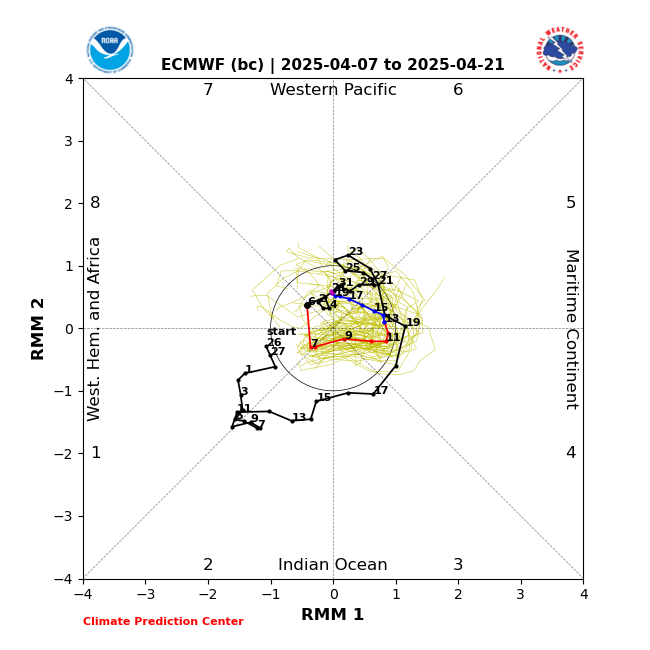
For reference, here's a MJO Phase chart:

And here is the ECMWF Extended Ensemble forecast:

To start off, here's why I still expect the MJO signal to collapse as it continues through Phase 3 and then into Phase 4:
1.

Note the substantially below-average SST anomalies in the eastern Bay of Bengal coming into the Maritime Continent. Per the map above, this is in the MJO Phase 3-4 area. Cooler water helps to inhibit convection through two different mechanisms: 1. increases surface pressure/divergence/stability relative to surrounding areas that have above-average SST anomalies 2. decreases latent heat/moisture fluxes from the ocean's surface into the lower atmosphere.
Also note the relatively warmer SST anomalies across the central and eastern Pacific, western Indian, and all of the tropical Atlantic Oceans compared to the above-average anomalies located in the Maritime Continent. This also helps to enhance the above mechanisms and their effects.
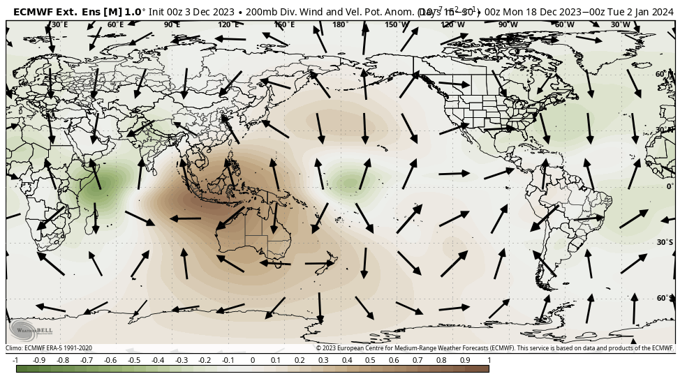
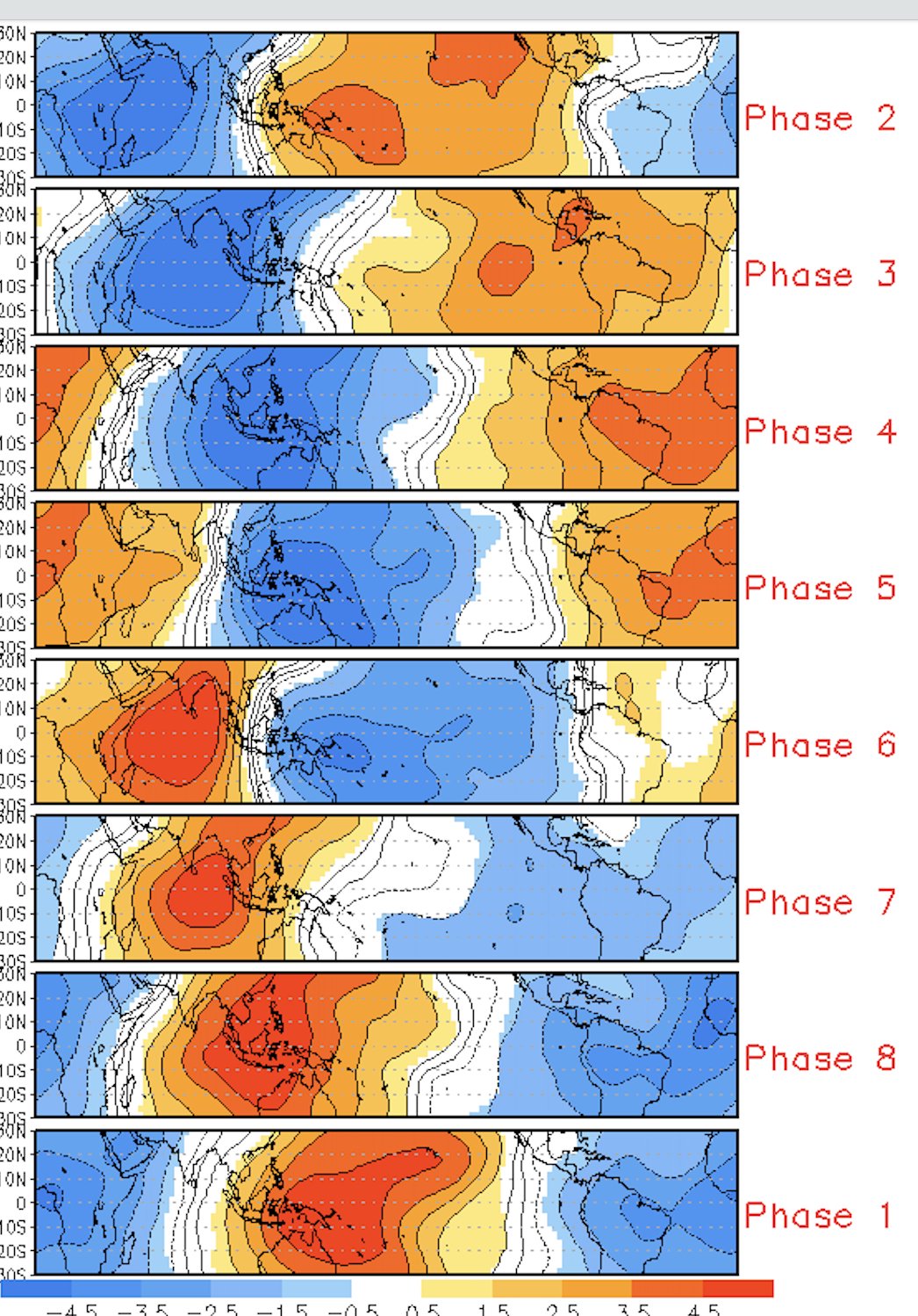
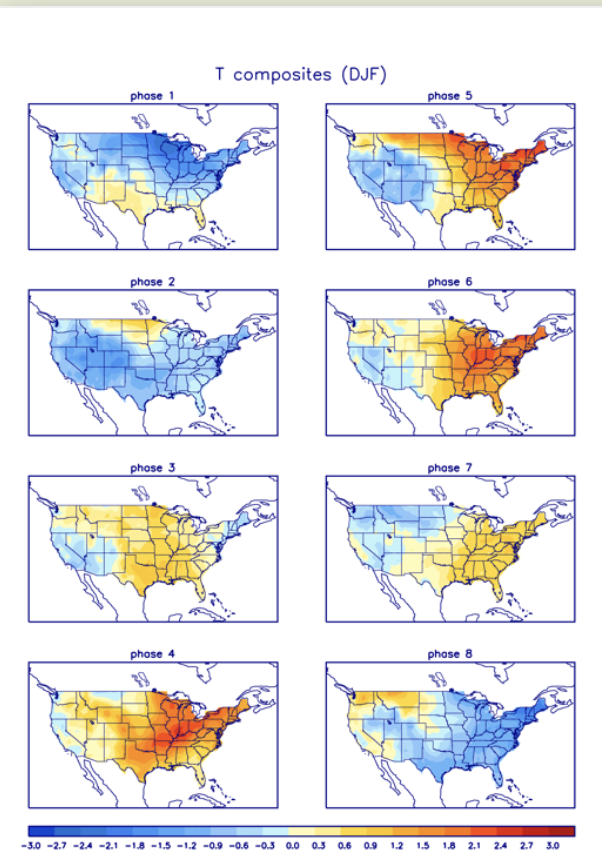
2. Take a look at the observed and forecast velocity potential at the 200 hPa level (green indicates divergence at 200 hPa, brown indicates convergence at 200 hPa. Divergence at this level is associated with convergence/lower pressure at the lower levels, and therefore, forcing for ascent. Convergence at this level is associated with divergence/higher pressure at the lower levels, and therefore, forcing for subsidence.). Notice that as we go forward a few days, there is strong support for divergence at the 200 hPa level from about 120ºW longitude through about 60ºE longitude, which corresponds to MJO phases 1 and 2 per the chart above (which generally correspond to below-average temperatures for the eastern U.S. in Phase 1, moderating in Phase 2). Also notice that there is strong support for convergence at the 200 hPa level from about 60ºE longitude through about 150ºE, and then again from about 180ºE/W (International Dateline) to about 120ºW., which generally correspond to MJO phases 3 through 8 (which generally correspond to above-average temperatures for the eastern U.S. in Phases 3 through 6, and below average temperatures in Phases 7 and


3. Similarly to the (2) above, take a look at the precipitable water anomalies at 200 hPa. Notice how the positive anomalies (which imply a sufficiently moist atmospheric column and conducive environment for deep tropical convection) overlap nearly perfectly with the same areas of divergence at this same level, while the negative anomalies (which imply a sufficiently dry atmospheric column and non-conducive environment for deep tropical convection) also nearly perfectly align with the same areas of convergence at this same level.

4. As support to the above three points, here's the current infrared satellite imagery of the globe; notice how there is notably deeper convection in the western Bay of Bengal (85ºE longitude and further west) as well as along and east of 160ºE longitude. Both of these areas correspond to the areas mentioned above where the warmest SST anomalies, 200 hPa divergence and moist atmospheric column all overlap. Between these two regions, however, there is a relative lack of any deep convection over the Maritime Continent.

Additionally, there are currently two active Invest areas conveniently located in these same regions:

The one in the western Bay of Bengal is likely the reason why the MJO forecasts are showing an increased amplitude in MJO Phase 2. Meanwhile, the one located near 165ºE longitude (approximately MJO Phase 7, associated with an eastward propagating Kelvin wave) will recurve toward MJO Phase 8 as it strengthens, which will likely appear as an enhanced Phase 7/8 on MJO forecasts in subsequent model runs.
Based on the above information, I think the models are picking up on the Invest in the western Bay of Bengal, but are then carrying that signal forward with time instead of diminishing it through MJO Phases 4 through 7, as would typically be expected based on the several factors present in and over the Maritime Continent that will destructively interfere with the MJO pulse and the deep convection associated with it. I would then expect to see it start regaining amplitude into Phase 8 and then re-emerge from the Null Phase as it gets closer to Phase 1 sometime around Week 3 of December (mid-month and beyond). That said, the MJO plots that we look at do not only incorporate the convective signal, but also the associated atmospheric circulations, so it's possible that those plots still appear to indicate a rotation with minimal amplitude just outside of the Null Phase, but even if they do, I do not expect the same type of atmospheric response. Without the deep convection to add abundant latent heat fluxes through its passage over the Maritime Continent, its input to the overall system will be extremely muted in my opinion, which brings me to the second point of my discussion; that I do not see December averaging out to be significantly above average with respect to temperature.
Based on the above assumption, I expect the pattern to get progressively colder for the eastern U.S. as we approach and then eclipse approximately Week 3 of December (mid-month and beyond), with generally near average temperatures as a whole through the first half of the month, maybe biased slightly cool.
As secondary supporting evidence, all three major model ensembles (GEFS, GEPS, EPS) all have an east-based NAO block re-firing by the end of Week 1, however, they differ on how it progresses, which, therefore, impacts our sensible weather. The GEFS and EPS both keep it stagnated as an east-based block with little if any westward propagation through the end of Week 2, though the GEFS try hinting that some of it tries to bleed westward. The GEPS doesn't do this; it steadily retrogrades the block, which is the evolution that I favor based on the past precedent of this entire year. Each time blocking has initiated in the Atlantic domain, it has retrograded all the way back to the western shore of Hudson Bay before decaying, and I see no reason that it wouldn't again. As a result, this would lead to yet another storm opportunity between about December 11th-15th, as the +PNA and Hudson Bay ridge become established again. Another red flag to me that the GEPS is on the right track is that all three ensembles have a strong signal for a 70ºN/70ºE ridge which is also associated with the initiation of the east-based NAO blocking, and is one of the pillars that I look for with respect to "anchoring" a pattern. Typically, when there is a ridge in this position, there is a corresponding trough over the eastern U.S. due to how atmospheric wavelengths are during the cold season. It's not always the case, but anecdotally, it usually seems to work pretty well. Similarly, if there is a trough in that location, then usually ridging tries to develop over the eastern U.S.
Lastly, there is an ongoing drop of the SST anomalies in Niño region 1.2, as depicted below. It's currently at about a 0.6ºC drop since November 24th, but based on projections, this should generally continue, and I think it will reach and/or exceed a 1ºC change, which is my threshold of consideration for atmospheric impacts. Generally, this signal takes 2-3 weeks to show up, and corresponds to a height field of same anomaly over the eastern U.S. (i.e. a 1ºC or greater fall in the SST anomalies in Niño region 1.2 corresponds to anomalous troughing over the eastern U.S. 2-3 weeks later, whereas a rise of similar magnitude corresponds to anomalous ridging over the eastern U.S. 2-3 weeks later).

Based on the above, I expect some large corrections to the appearance of the pattern in the extended range on both the EPS and GEFS going forward into mid-month and thereafter, but we shall see. I also expect things to really ramp up into the New Year and beyond, as the Stratosphere looks to play its hand. I think we see multiple hits/warming events to it this year in favorable locations, which should work in our favor.
Anyway, hopefully that makes some sense, but if not, I welcome any questions and/or further comments
As brother sroc would say, WE TRACK!
rb924119- Meteorologist

- Posts : 7033
Reputation : 195
Join date : 2013-02-06
Age : 32
Location : Greentown, Pa
sroc4, docstox12, kalleg, crippo84, SENJsnowman and Irish like this post
Re: Long Range Thread 27.0
![]() by Frozen.9 Sat Dec 02, 2023 3:04 am
by Frozen.9 Sat Dec 02, 2023 3:04 am
Frozen.9- Posts : 33
Reputation : 0
Join date : 2021-02-06
sroc4, weatherwatchermom and Irish like this post
Re: Long Range Thread 27.0
![]() by heehaw453 Sat Dec 02, 2023 8:01 am
by heehaw453 Sat Dec 02, 2023 8:01 am
rb924119 wrote:I'm just going to throw my two cents in here because the two of you (sroc and heehaw) have a great discussion going. Since it's not usually a good idea to "bury the lead", I'll start with my opinion and then elaborate:
I agree with heehaw with respect to the current MJO outlook - I think that most of the current guidance is exaggerating the signal, which is negatively affecting the output in the extended range (EXCEPT ECMWF Extended Ensemble, where most members collapse into the null phase upon entering Phase 4). However, I disagree that December will finish above average with respect to temperatures (i.e. >+1ºF). I think we go back and forth for the front ten days or so of the month, and then progressively get colder. To preface the following discussion, I am considering a neutral ENSO base state given the large disconnect between the ONI (Oceanic Niño Index, which only considers the state of the ocean temperatures) and MEI (Multivariate ENSO Index, which accounts for the atmospheric and oceanic states).
For reference, here's a MJO Phase chart:
And here is the ECMWF Extended Ensemble forecast:
To start off, here's why I still expect the MJO signal to collapse as it continues through Phase 3 and then into Phase 4:
1.
Note the substantially below-average SST anomalies in the eastern Bay of Bengal coming into the Maritime Continent. Per the map above, this is in the MJO Phase 3-4 area. Cooler water helps to inhibit convection through two different mechanisms: 1. increases surface pressure/divergence/stability relative to surrounding areas that have above-average SST anomalies 2. decreases latent heat/moisture fluxes from the ocean's surface into the lower atmosphere.
Also note the relatively warmer SST anomalies across the central and eastern Pacific, western Indian, and all of the tropical Atlantic Oceans compared to the above-average anomalies located in the Maritime Continent. This also helps to enhance the above mechanisms and their effects.
2. Take a look at the observed and forecast velocity potential at the 200 hPa level (green indicates divergence at 200 hPa, brown indicates convergence at 200 hPa. Divergence at this level is associated with convergence/lower pressure at the lower levels, and therefore, forcing for ascent. Convergence at this level is associated with divergence/higher pressure at the lower levels, and therefore, forcing for subsidence.). Notice that as we go forward a few days, there is strong support for divergence at the 200 hPa level from about 120ºW longitude through about 60ºE longitude, which corresponds to MJO phases 1 and 2 per the chart above (which generally correspond to below-average temperatures for the eastern U.S. in Phase 1, moderating in Phase 2). Also notice that there is strong support for convergence at the 200 hPa level from about 60ºE longitude through about 150ºE, and then again from about 180ºE/W (International Dateline) to about 120ºW., which generally correspond to MJO phases 3 through 8 (which generally correspond to above-average temperatures for the eastern U.S. in Phases 3 through 6, and below average temperatures in Phases 7 and.
3. Similarly to the (2) above, take a look at the precipitable water anomalies at 200 hPa. Notice how the positive anomalies (which imply a sufficiently moist atmospheric column and conducive environment for deep tropical convection) overlap nearly perfectly with the same areas of divergence at this same level, while the negative anomalies (which imply a sufficiently dry atmospheric column and non-conducive environment for deep tropical convection) also nearly perfectly align with the same areas of convergence at this same level.
4. As support to the above three points, here's the current infrared satellite imagery of the globe; notice how there is notably deeper convection in the western Bay of Bengal (85ºE longitude and further west) as well as along and east of 160ºE longitude. Both of these areas correspond to the areas mentioned above where the warmest SST anomalies, 200 hPa divergence and moist atmospheric column all overlap. Between these two regions, however, there is a relative lack of any deep convection over the Maritime Continent.
Additionally, there are currently two active Invest areas conveniently located in these same regions:
The one in the western Bay of Bengal is likely the reason why the MJO forecasts are showing an increased amplitude in MJO Phase 2. Meanwhile, the one located near 165ºE longitude (approximately MJO Phase 7, associated with an eastward propagating Kelvin wave) will recurve toward MJO Phase 8 as it strengthens, which will likely appear as an enhanced Phase 7/8 on MJO forecasts in subsequent model runs.
Based on the above information, I think the models are picking up on the Invest in the western Bay of Bengal, but are then carrying that signal forward with time instead of diminishing it through MJO Phases 4 through 7, as would typically be expected based on the several factors present in and over the Maritime Continent that will destructively interfere with the MJO pulse and the deep convection associated with it. I would then expect to see it start regaining amplitude into Phase 8 and then re-emerge from the Null Phase as it gets closer to Phase 1 sometime around Week 3 of December (mid-month and beyond). That said, the MJO plots that we look at do not only incorporate the convective signal, but also the associated atmospheric circulations, so it's possible that those plots still appear to indicate a rotation with minimal amplitude just outside of the Null Phase, but even if they do, I do not expect the same type of atmospheric response. Without the deep convection to add abundant latent heat fluxes through its passage over the Maritime Continent, its input to the overall system will be extremely muted in my opinion, which brings me to the second point of my discussion; that I do not see December averaging out to be significantly above average with respect to temperature.
Based on the above assumption, I expect the pattern to get progressively colder for the eastern U.S. as we approach and then eclipse approximately Week 3 of December (mid-month and beyond), with generally near average temperatures as a whole through the first half of the month, maybe biased slightly cool.
As secondary supporting evidence, all three major model ensembles (GEFS, GEPS, EPS) all have an east-based NAO block re-firing by the end of Week 1, however, they differ on how it progresses, which, therefore, impacts our sensible weather. The GEFS and EPS both keep it stagnated as an east-based block with little if any westward propagation through the end of Week 2, though the GEFS try hinting that some of it tries to bleed westward. The GEPS doesn't do this; it steadily retrogrades the block, which is the evolution that I favor based on the past precedent of this entire year. Each time blocking has initiated in the Atlantic domain, it has retrograded all the way back to the western shore of Hudson Bay before decaying, and I see no reason that it wouldn't again. As a result, this would lead to yet another storm opportunity between about December 11th-15th, as the +PNA and Hudson Bay ridge become established again. Another red flag to me that the GEPS is on the right track is that all three ensembles have a strong signal for a 70ºN/70ºE ridge which is also associated with the initiation of the east-based NAO blocking, and is one of the pillars that I look for with respect to "anchoring" a pattern. Typically, when there is a ridge in this position, there is a corresponding trough over the eastern U.S. due to how atmospheric wavelengths are during the cold season. It's not always the case, but anecdotally, it usually seems to work pretty well. Similarly, if there is a trough in that location, then usually ridging tries to develop over the eastern U.S.
Lastly, there is an ongoing drop of the SST anomalies in Niño region 1.2, as depicted below. It's currently at about a 0.6ºC drop since November 24th, but based on projections, this should generally continue, and I think it will reach and/or exceed a 1ºC change, which is my threshold of consideration for atmospheric impacts. Generally, this signal takes 2-3 weeks to show up, and corresponds to a height field of same anomaly over the eastern U.S. (i.e. a 1ºC or greater fall in the SST anomalies in Niño region 1.2 corresponds to anomalous troughing over the eastern U.S. 2-3 weeks later, whereas a rise of similar magnitude corresponds to anomalous ridging over the eastern U.S. 2-3 weeks later).
Based on the above, I expect some large corrections to the appearance of the pattern in the extended range on both the EPS and GEFS going forward into mid-month and thereafter, but we shall see. I also expect things to really ramp up into the New Year and beyond, as the Stratosphere looks to play its hand. I think we see multiple hits/warming events to it this year in favorable locations, which should work in our favor.
Anyway, hopefully that makes some sense, but if not, I welcome any questions and/or further comments
As brother sroc would say, WE TRACK!
Well done! It takes time, knowledge and effort to do this and it's highly appreciated. You and sroc always take the deep dive!
heehaw453- Advanced Forecaster
- Posts : 3907
Reputation : 86
Join date : 2014-01-20
Location : Bedminster Township, PA Elevation 600' ASL
sroc4, docstox12, rb924119, nancy-j-s, crippo84, SENJsnowman and MattyICE like this post
Re: Long Range Thread 27.0
![]() by sroc4 Sat Dec 02, 2023 10:24 am
by sroc4 Sat Dec 02, 2023 10:24 am

_________________
"In weather and in life, there's no winning and losing; there's only winning and learning."
WINTER 2012/2013 TOTALS 43.65"WINTER 2017/2018 TOTALS 62.85" WINTER 2022/2023 TOTALS 4.9"
WINTER 2013/2014 TOTALS 64.85"WINTER 2018/2019 TOTALS 14.25" WINTER 2023/2024 TOTALS 13.1"
WINTER 2014/2015 TOTALS 71.20"WINTER 2019/2020 TOTALS 6.35"
WINTER 2015/2016 TOTALS 35.00"WINTER 2020/2021 TOTALS 37.75"
WINTER 2016/2017 TOTALS 42.25"WINTER 2021/2022 TOTALS 31.65"
sroc4- Admin
- Posts : 8441
Reputation : 302
Join date : 2013-01-07
Location : Wading River, LI
rb924119, crippo84, brownie, heehaw453, Sparky Sparticles, MattyICE and Irish like this post
Re: Long Range Thread 27.0
![]() by rb924119 Sat Dec 02, 2023 10:27 am
by rb924119 Sat Dec 02, 2023 10:27 am


rb924119- Meteorologist
- Posts : 7033
Reputation : 195
Join date : 2013-02-06
Age : 32
Location : Greentown, Pa
sroc4, heehaw453 and Sparky Sparticles like this post
Re: Long Range Thread 27.0
![]() by frank 638 Sat Dec 02, 2023 10:44 am
by frank 638 Sat Dec 02, 2023 10:44 am
that looks delicious. I will bring the wine and I’ll bring dessert I will bring toasted almond cake and tiramisu lolsroc4 wrote:Heehaw and Ray. I truly appreciate both of you on this board. I am already formulating ideas in my mind, both in agreement and still to a degree disagree over and believe it could add to the already phenomenal discussion. That said I am currently however in the process of finishing off a delectable Pork Butt that has been on my smoker since about 11pm last night. Tonight is a pot luck Xmas party of which pulled pork sliders will be my contribution. I’m hopeful that I will have the time either today or tomorrow to respond back. Cheers
frank 638- Senior Enthusiast

- Posts : 2861
Reputation : 37
Join date : 2016-01-01
Age : 41
Location : bronx ny
sroc4, rb924119 and heehaw453 like this post
Re: Long Range Thread 27.0
![]() by Irish Sat Dec 02, 2023 4:58 pm
by Irish Sat Dec 02, 2023 4:58 pm
🤪

Irish- Pro Enthusiast

- Posts : 788
Reputation : 19
Join date : 2019-01-16
Age : 46
Location : Old Bridge, NJ
sroc4, rb924119, Grselig, nancy-j-s and weatherwatchermom like this post
Re: Long Range Thread 27.0
![]() by sroc4 Sun Dec 03, 2023 12:00 pm
by sroc4 Sun Dec 03, 2023 12:00 pm
rb924119 wrote:I'm just going to throw my two cents in here because the two of you (sroc and heehaw) have a great discussion going. Since it's not usually a good idea to "bury the lead", I'll start with my opinion and then elaborate:
I agree with heehaw with respect to the current MJO outlook - I think that most of the current guidance is exaggerating the signal, which is negatively affecting the output in the extended range (EXCEPT ECMWF Extended Ensemble, where most members collapse into the null phase upon entering Phase 4). However, I disagree that December will finish above average with respect to temperatures (i.e. >+1ºF). I think we go back and forth for the front ten days or so of the month, and then progressively get colder. To preface the following discussion, I am considering a neutral ENSO base state given the large disconnect between the ONI (Oceanic Niño Index, which only considers the state of the ocean temperatures) and MEI (Multivariate ENSO Index, which accounts for the atmospheric and oceanic states).
For reference, here's a MJO Phase chart:
And here is the ECMWF Extended Ensemble forecast:
To start off, here's why I still expect the MJO signal to collapse as it continues through Phase 3 and then into Phase 4:
1.
Note the substantially below-average SST anomalies in the eastern Bay of Bengal coming into the Maritime Continent. Per the map above, this is in the MJO Phase 3-4 area. Cooler water helps to inhibit convection through two different mechanisms: 1. increases surface pressure/divergence/stability relative to surrounding areas that have above-average SST anomalies 2. decreases latent heat/moisture fluxes from the ocean's surface into the lower atmosphere.
Also note the relatively warmer SST anomalies across the central and eastern Pacific, western Indian, and all of the tropical Atlantic Oceans compared to the above-average anomalies located in the Maritime Continent. This also helps to enhance the above mechanisms and their effects.
2. Take a look at the observed and forecast velocity potential at the 200 hPa level (green indicates divergence at 200 hPa, brown indicates convergence at 200 hPa. Divergence at this level is associated with convergence/lower pressure at the lower levels, and therefore, forcing for ascent. Convergence at this level is associated with divergence/higher pressure at the lower levels, and therefore, forcing for subsidence.). Notice that as we go forward a few days, there is strong support for divergence at the 200 hPa level from about 120ºW longitude through about 60ºE longitude, which corresponds to MJO phases 1 and 2 per the chart above (which generally correspond to below-average temperatures for the eastern U.S. in Phase 1, moderating in Phase 2). Also notice that there is strong support for convergence at the 200 hPa level from about 60ºE longitude through about 150ºE, and then again from about 180ºE/W (International Dateline) to about 120ºW., which generally correspond to MJO phases 3 through 8 (which generally correspond to above-average temperatures for the eastern U.S. in Phases 3 through 6, and below average temperatures in Phases 7 and
3. Similarly to the (2) above, take a look at the precipitable water anomalies at 200 hPa. Notice how the positive anomalies (which imply a sufficiently moist atmospheric column and conducive environment for deep tropical convection) overlap nearly perfectly with the same areas of divergence at this same level, while the negative anomalies (which imply a sufficiently dry atmospheric column and non-conducive environment for deep tropical convection) also nearly perfectly align with the same areas of convergence at this same level.
4. As support to the above three points, here's the current infrared satellite imagery of the globe; notice how there is notably deeper convection in the western Bay of Bengal (85ºE longitude and further west) as well as along and east of 160ºE longitude. Both of these areas correspond to the areas mentioned above where the warmest SST anomalies, 200 hPa divergence and moist atmospheric column all overlap. Between these two regions, however, there is a relative lack of any deep convection over the Maritime Continent.
Additionally, there are currently two active Invest areas conveniently located in these same regions:
The one in the western Bay of Bengal is likely the reason why the MJO forecasts are showing an increased amplitude in MJO Phase 2. Meanwhile, the one located near 165ºE longitude (approximately MJO Phase 7, associated with an eastward propagating Kelvin wave) will recurve toward MJO Phase 8 as it strengthens, which will likely appear as an enhanced Phase 7/8 on MJO forecasts in subsequent model runs.
Based on the above information, I think the models are picking up on the Invest in the western Bay of Bengal, but are then carrying that signal forward with time instead of diminishing it through MJO Phases 4 through 7, as would typically be expected based on the several factors present in and over the Maritime Continent that will destructively interfere with the MJO pulse and the deep convection associated with it. I would then expect to see it start regaining amplitude into Phase 8 and then re-emerge from the Null Phase as it gets closer to Phase 1 sometime around Week 3 of December (mid-month and beyond). That said, the MJO plots that we look at do not only incorporate the convective signal, but also the associated atmospheric circulations, so it's possible that those plots still appear to indicate a rotation with minimal amplitude just outside of the Null Phase, but even if they do, I do not expect the same type of atmospheric response. Without the deep convection to add abundant latent heat fluxes through its passage over the Maritime Continent, its input to the overall system will be extremely muted in my opinion, which brings me to the second point of my discussion; that I do not see December averaging out to be significantly above average with respect to temperature.
Based on the above assumption, I expect the pattern to get progressively colder for the eastern U.S. as we approach and then eclipse approximately Week 3 of December (mid-month and beyond), with generally near average temperatures as a whole through the first half of the month, maybe biased slightly cool.
As secondary supporting evidence, all three major model ensembles (GEFS, GEPS, EPS) all have an east-based NAO block re-firing by the end of Week 1, however, they differ on how it progresses, which, therefore, impacts our sensible weather. The GEFS and EPS both keep it stagnated as an east-based block with little if any westward propagation through the end of Week 2, though the GEFS try hinting that some of it tries to bleed westward. The GEPS doesn't do this; it steadily retrogrades the block, which is the evolution that I favor based on the past precedent of this entire year. Each time blocking has initiated in the Atlantic domain, it has retrograded all the way back to the western shore of Hudson Bay before decaying, and I see no reason that it wouldn't again. As a result, this would lead to yet another storm opportunity between about December 11th-15th, as the +PNA and Hudson Bay ridge become established again. Another red flag to me that the GEPS is on the right track is that all three ensembles have a strong signal for a 70ºN/70ºE ridge which is also associated with the initiation of the east-based NAO blocking, and is one of the pillars that I look for with respect to "anchoring" a pattern. Typically, when there is a ridge in this position, there is a corresponding trough over the eastern U.S. due to how atmospheric wavelengths are during the cold season. It's not always the case, but anecdotally, it usually seems to work pretty well. Similarly, if there is a trough in that location, then usually ridging tries to develop over the eastern U.S.
Lastly, there is an ongoing drop of the SST anomalies in Niño region 1.2, as depicted below. It's currently at about a 0.6ºC drop since November 24th, but based on projections, this should generally continue, and I think it will reach and/or exceed a 1ºC change, which is my threshold of consideration for atmospheric impacts. Generally, this signal takes 2-3 weeks to show up, and corresponds to a height field of same anomaly over the eastern U.S. (i.e. a 1ºC or greater fall in the SST anomalies in Niño region 1.2 corresponds to anomalous troughing over the eastern U.S. 2-3 weeks later, whereas a rise of similar magnitude corresponds to anomalous ridging over the eastern U.S. 2-3 weeks later).
Based on the above, I expect some large corrections to the appearance of the pattern in the extended range on both the EPS and GEFS going forward into mid-month and thereafter, but we shall see. I also expect things to really ramp up into the New Year and beyond, as the Stratosphere looks to play its hand. I think we see multiple hits/warming events to it this year in favorable locations, which should work in our favor.
Anyway, hopefully that makes some sense, but if not, I welcome any questions and/or further comments
As brother sroc would say, WE TRACK!
First off let me say whenever someone challenges your ideas it forces you to go back and reassess your thoughts. This is where learning comes from. I appreciate both you and Heehaws thoughts despite the fact that we may disagree on certain points.
Let me summarize the conclusions. I think we are both in overall agreement that we are waiting until about Dec 20th and beyond for the real magic to happen. For me my overall argument isnt necessarily where the month of Dec falls temp anomaly wise, but rather the forecasted MJO has merit in both current observations as well as model forecasts to support linkages to the warmer phases such that storm tracks into and around our region will struggle to tap into the cold air sources and be on the warmer side of solns until after the third week of Dec at the earliest. It doesnt mean we cant/wont snow, esp off the coastal plain as climatology conts to favor the interior as we head deeper into the month.

The Invest in the Bay of Bengal and associated convection is in the Phase 3-4 region. Regardless of whats going on elsewhere in the trop Pac, current observation show a clear link to the atmpsohere in the phase 3-4-5 region. https://www.goes.noaa.gov/dml/jma/fd/wvblue.html

Looking at PWAT forecasts, and precipitation forecasts along this area of the Pacific there looks to be a link to cont to a certain degree. Now as you pointed out there are other areas linking to the northern latitudes which might mitigate what the true phase 3-6 MJO might look like on the 500mb pattern over the NE but ther is enough there to suggest that until that linkage tempers there likely will be an influence on just how much cold air will be available to any storm headed our way.
I have to be honest Im actually pretty hung over right now and realize I cant keep going. My brain hurts. LOL
Bottom line is I think Dec through about the 20th will average approx 1-1.5* AN and the storm systems will really struggle to produce white for most, but.......
WE TRACK

_________________
"In weather and in life, there's no winning and losing; there's only winning and learning."
WINTER 2012/2013 TOTALS 43.65"WINTER 2017/2018 TOTALS 62.85" WINTER 2022/2023 TOTALS 4.9"
WINTER 2013/2014 TOTALS 64.85"WINTER 2018/2019 TOTALS 14.25" WINTER 2023/2024 TOTALS 13.1"
WINTER 2014/2015 TOTALS 71.20"WINTER 2019/2020 TOTALS 6.35"
WINTER 2015/2016 TOTALS 35.00"WINTER 2020/2021 TOTALS 37.75"
WINTER 2016/2017 TOTALS 42.25"WINTER 2021/2022 TOTALS 31.65"
sroc4- Admin
- Posts : 8441
Reputation : 302
Join date : 2013-01-07
Location : Wading River, LI
rb924119, heehaw453, weatherwatchermom and MattyICE like this post
Re: Long Range Thread 27.0
![]() by heehaw453 Sun Dec 03, 2023 1:13 pm
by heehaw453 Sun Dec 03, 2023 1:13 pm
Observed and progged AO

With this kind of trough in eastern US I would expect much colder temps than what we had towards end of November. But the coldest air is in Siberia and the EPO+ (trough in Alaska) is helping lock it in place.
End of November 2023 500mb

If you recall from last December we actually had a favorable NAM state with good EPO- which resulted in significantly BN temps. Of course no discreet threat worked out. In December it requires longer wave lengths for s/w's to amp up and westerns trough (PNA-) was a big reason nothing worked out.
Once nina really kicked in and amped up the SER it was lights out until some well NW got snowfall in March.
I guess the main point to this post is nothing stands alone with our sensible weather and it's very delicate balance between a good winter and a dud. When you start noticing something really hostile to winter weather, then pay attention to it as that usually disturbs that delicate balance in one way or another.
What I find great about the board is areas where my knowledge is lighter gets enhanced every year.
December 2022 500 mb

heehaw453- Advanced Forecaster
- Posts : 3907
Reputation : 86
Join date : 2014-01-20
Location : Bedminster Township, PA Elevation 600' ASL
sroc4, rb924119 and weatherwatchermom like this post
Re: Long Range Thread 27.0
![]() by sroc4 Mon Dec 04, 2023 7:37 am
by sroc4 Mon Dec 04, 2023 7:37 am
A legit test is on the horizon. On one hand there is a legit argument to be made, most recently by Rb(Ray), that our MJO will re-emerge in more favorable phases. In addition, and we have yet to really discuss this much in here, a significant strat warming is currently taking place which looks to continue to occur over the next 2-3weeks such that the end result is at the very least a weakened and stretched state and in a position that SHOULD be favorable for the eastern CONUS.


But when looking at the teleconnections, both Euro and GFS are similar, our AO moves towards positive, our EPO remains strongly +, our NAO moves towards positive, and our PNA moves towards negative. Both EPS and GEFS hint at this in their 500mb pattern towards the end of their respective runs.


The look on those two 500mb images is about as ugly as it gets for a winter weather weenie. So the question is...Is this real? Do we have to endure it getting worse before it gets better? Does the current LT evolve over time into something that ends up more favorable than what is being predicted? Delayed, but not denied, or delayed; delayed again..and again? Time will tell. My opinion on what we are seeing above is the result of the MJO rotating through the warm phases of the MJO as discussed over the weekend, and we are going to need to be patient. I still think it’s going to get a bit wild around these parts around Xmas time; though the new year as a result of the effects on the Strat as well as the mjo re emerging back out into more favorable phases.
_________________
"In weather and in life, there's no winning and losing; there's only winning and learning."
WINTER 2012/2013 TOTALS 43.65"WINTER 2017/2018 TOTALS 62.85" WINTER 2022/2023 TOTALS 4.9"
WINTER 2013/2014 TOTALS 64.85"WINTER 2018/2019 TOTALS 14.25" WINTER 2023/2024 TOTALS 13.1"
WINTER 2014/2015 TOTALS 71.20"WINTER 2019/2020 TOTALS 6.35"
WINTER 2015/2016 TOTALS 35.00"WINTER 2020/2021 TOTALS 37.75"
WINTER 2016/2017 TOTALS 42.25"WINTER 2021/2022 TOTALS 31.65"
sroc4- Admin
- Posts : 8441
Reputation : 302
Join date : 2013-01-07
Location : Wading River, LI
rb924119 and heehaw453 like this post
Re: Long Range Thread 27.0
![]() by amugs Mon Dec 04, 2023 9:37 am
by amugs Mon Dec 04, 2023 9:37 am
SON tri monthly oni comes in at 1.8...nearing a low end strong el nino...MEI is not in yet...weekly oni was 2.0...slightly lower than last week...hopefully its peaking now...I expect the mei number to be close to 1.0.
For reference, 2009 peaked at +1.9 in the weekly 3.4 ENSO values, 1997 peaked at +2.8, & 2016 peaked at +3.0. So we would most likely need to peak at something close to +2.4 in the weekly Niño 3.4 values for this to register as a super Niño in the CPC ONI.
Seems unlikely with the trades forecasted over the next couple weeks
1.2 Peaked - a double and usually means its over - no signs of a WWB to propel this

3.4 Region is 1.5 = moderate nino (from waht is considered by NOAA's indicators)

You can see the dark blue areas of SA coast for 1.2 drastic cooling

_________________
Mugs
AKA:King: Snow Weenie
Self Proclaimed
WINTER 2014-15 : 55.12" +.02 for 6 coatings (avg. 35")
WINTER 2015-16 Total - 29.8" (Avg 35")
WINTER 2016-17 : 39.5" so far

amugs- Advanced Forecaster - Mod
- Posts : 15130
Reputation : 213
Join date : 2013-01-07
Age : 54
Location : Hillsdale,NJ
rb924119 and heehaw453 like this post
Re: Long Range Thread 27.0
![]() by amugs Mon Dec 04, 2023 9:48 am
by amugs Mon Dec 04, 2023 9:48 am
The drying around the maritime continent is huge as is the convections in Phase 8 and 1
_________________
Mugs
AKA:King: Snow Weenie
Self Proclaimed
WINTER 2014-15 : 55.12" +.02 for 6 coatings (avg. 35")
WINTER 2015-16 Total - 29.8" (Avg 35")
WINTER 2016-17 : 39.5" so far
amugs- Advanced Forecaster - Mod
- Posts : 15130
Reputation : 213
Join date : 2013-01-07
Age : 54
Location : Hillsdale,NJ
rb924119 and heehaw453 like this post
Re: Long Range Thread 27.0
![]() by jmanley32 Mon Dec 04, 2023 6:23 pm
by jmanley32 Mon Dec 04, 2023 6:23 pm

jmanley32- Senior Enthusiast
- Posts : 20635
Reputation : 108
Join date : 2013-12-12
Age : 43
Location : Yonkers, NY
Re: Long Range Thread 27.0
![]() by amugs Mon Dec 04, 2023 7:02 pm
by amugs Mon Dec 04, 2023 7:02 pm
No you are not reading or guessing correctly. Once we flip into phases 7 then 8 game on, by midish month ~16thish onward, for the entire region for snow. Forget the last 2 winters, this winter is nothing like that.We have a good stretch coming and with the PV elongation, warming as pronged good things are in the cards.jmanley32 wrote:Havent had time to read all this detailed analysis but from looking a LR GFS every system cuts to the west through the GL. My guess is especially us coasties we will have to wait until january for a chance at snow. I wouldn't be surprised if it took till after the new year for inland too, could that change of course but I see a big pattern of storms just continually cutting west into GL. Do not like it one bit.
Now look at these charts. Again the brown is drying and the wave fast tracks through the warm phases, even faster than 3 days ago that had this for Dec 17thish now it's sped it up to Dec
12/13thish. Remember a few days lag but the NAO and AO seem to keep things at bay so when this happens they can anchor in.


_________________
Mugs
AKA:King: Snow Weenie
Self Proclaimed
WINTER 2014-15 : 55.12" +.02 for 6 coatings (avg. 35")
WINTER 2015-16 Total - 29.8" (Avg 35")
WINTER 2016-17 : 39.5" so far
amugs- Advanced Forecaster - Mod
- Posts : 15130
Reputation : 213
Join date : 2013-01-07
Age : 54
Location : Hillsdale,NJ
rb924119 likes this post
Re: Long Range Thread 27.0
![]() by amugs Mon Dec 04, 2023 7:03 pm
by amugs Mon Dec 04, 2023 7:03 pm

_________________
Mugs
AKA:King: Snow Weenie
Self Proclaimed
WINTER 2014-15 : 55.12" +.02 for 6 coatings (avg. 35")
WINTER 2015-16 Total - 29.8" (Avg 35")
WINTER 2016-17 : 39.5" so far
amugs- Advanced Forecaster - Mod
- Posts : 15130
Reputation : 213
Join date : 2013-01-07
Age : 54
Location : Hillsdale,NJ
rb924119 likes this post
Re: Long Range Thread 27.0
![]() by amugs Mon Dec 04, 2023 9:34 pm
by amugs Mon Dec 04, 2023 9:34 pm

_________________
Mugs
AKA:King: Snow Weenie
Self Proclaimed
WINTER 2014-15 : 55.12" +.02 for 6 coatings (avg. 35")
WINTER 2015-16 Total - 29.8" (Avg 35")
WINTER 2016-17 : 39.5" so far
amugs- Advanced Forecaster - Mod
- Posts : 15130
Reputation : 213
Join date : 2013-01-07
Age : 54
Location : Hillsdale,NJ
Re: Long Range Thread 27.0
![]() by amugs Mon Dec 04, 2023 9:35 pm
by amugs Mon Dec 04, 2023 9:35 pm


_________________
Mugs
AKA:King: Snow Weenie
Self Proclaimed
WINTER 2014-15 : 55.12" +.02 for 6 coatings (avg. 35")
WINTER 2015-16 Total - 29.8" (Avg 35")
WINTER 2016-17 : 39.5" so far
amugs- Advanced Forecaster - Mod
- Posts : 15130
Reputation : 213
Join date : 2013-01-07
Age : 54
Location : Hillsdale,NJ
weatherwatchermom likes this post
Re: Long Range Thread 27.0
![]() by rb924119 Tue Dec 05, 2023 7:21 am
by rb924119 Tue Dec 05, 2023 7:21 am
Irish wrote:I have nothing of value to add, not a forecast, not a pork butt... nothing. However, does anyone else wonder if rb is human? That dude is absolutely brilliant! I read... rather I should say, sounds come out of my mouth as I decode letters from words in sentences he typed but most of it is just noise and not comprehended. I wish I could understand the words that are coming out of his mouth! I can't even say well done to him without lying.
🤪
Thanks, Irish, but I am indeed only a mortal haha if you want a further explanation of something that any of us say or have said in the past, please don’t ever hesitate to ask us. This forum is not only a place for enthusiasts of all ages and levels of knowledge to discuss the weather, but it’s also a great place to learn. And believe me, I’m pretty sure that I can speak for all of us, even our more experienced posters, when I say that we are ALL still learning, from both our own research and each other
rb924119- Meteorologist
- Posts : 7033
Reputation : 195
Join date : 2013-02-06
Age : 32
Location : Greentown, Pa
Sparky Sparticles and Irish like this post
Page 6 of 40 • 1 ... 5, 6, 7 ... 23 ... 40 ![]()
|
|
|