
 Search
Long Range Thread 27.0
Page 5 of 40 •  1, 2, 3, 4, 5, 6 ... 22 ... 40
 ![]()
Re: Long Range Thread 27.0
![]() by jmanley32 Tue Nov 21, 2023 9:56 pm
by jmanley32 Tue Nov 21, 2023 9:56 pm
I know that all to well, i really liked when phones had actual buttons. I had that sliding sideways one, i forget what it was called but it was great.Irish wrote:jmanley32 wrote:brownie wrote:I actually googled it. To no avail, of course. LOLIrish wrote:dkodgis wrote:Ha ha. I don’t know how that spelling got in there.
“cold” not vlof
Was really hoping that that was a special weather word that meant good things to come. However, now it's even funnier, oh, and cold is coming!
I think that should be a new board term. Like, "Baby, It's vlof outside."
It actually does stand for something. In aviation is means "lift off speed." I seen you continue to have that happen every popst you try to write cold in, maybe its a syntax prank lol
Edit, did not read the rest of the BANTER in long range, hey just calling it like it is haha. You all are too funny.
In all actuality it's probably just him fat-fingering cold. The v is right next to c, he's typing to quickly and switching the l and o and then the f is right next to the d.
jmanley32- Senior Enthusiast

- Posts : 20535
Join date : 2013-12-12
kalleg and Irish like this post
Re: Long Range Thread 27.0
![]() by rb924119 Thu Nov 23, 2023 12:12 pm
by rb924119 Thu Nov 23, 2023 12:12 pm
rb924119- Meteorologist

- Posts : 6928
Join date : 2013-02-06
docstox12, dkodgis, MattyICE, Irish and phil155 like this post
Re: Long Range Thread 27.0
![]() by heehaw453 Fri Nov 24, 2023 9:48 am
by heehaw453 Fri Nov 24, 2023 9:48 am
December 1-15 (2022) 500mb think very different this year

heehaw453- Advanced Forecaster

- Posts : 3906
Reputation : 86
Join date : 2014-01-20
Location : Bedminster Township, PA Elevation 600' ASL
Re: Long Range Thread 27.0
![]() by Frank_Wx Sat Nov 25, 2023 5:27 pm
by Frank_Wx Sat Nov 25, 2023 5:27 pm
Long range looks interesting. Some conflicting signals with the MJO and NAO. I’m thinking the 2nd week of December will bring a period of persistent below normal temperatures. Snow chances will be elevated as well. That’s a very nice looking +PNA and -NAO. Let’s see if it holds out
_________________
_______________________________________________________________________________________________________
CLICK HERE to view NJ Strong Snowstorm Classifications

Frank_Wx- Godzilla Seeker

- Posts : 21305
Reputation : 328
Join date : 2013-01-05
Age : 32
Location : Jersey City, NJ -

docstox12, kalleg, weatherwatchermom, MattyICE and Irish like this post
Re: Long Range Thread 27.0
![]() by Frank_Wx Sun Nov 26, 2023 8:46 am
by Frank_Wx Sun Nov 26, 2023 8:46 am


_________________
_______________________________________________________________________________________________________
CLICK HERE to view NJ Strong Snowstorm Classifications
Frank_Wx- Godzilla Seeker
- Posts : 21305
Reputation : 328
Join date : 2013-01-05
Age : 32
Location : Jersey City, NJ -
kalleg, nancy-j-s and Irish like this post
Re: Long Range Thread 27.0
![]() by heehaw453 Tue Nov 28, 2023 8:43 am
by heehaw453 Tue Nov 28, 2023 8:43 am
The issue I see is the antecedent air mass is warm due to a SER flexing on the east coast coupled with a poor EPO. My initial thought is I-84 corridor for a snowfall threat, but those along I78 and northward shouldn't sleep on this setup.

heehaw453- Advanced Forecaster
- Posts : 3906
Reputation : 86
Join date : 2014-01-20
Location : Bedminster Township, PA Elevation 600' ASL
Re: Long Range Thread 27.0
![]() by amugs Tue Nov 28, 2023 9:11 am
by amugs Tue Nov 28, 2023 9:11 am
ENS sniffing out the possibility
_________________
Mugs
AKA:King: Snow Weenie
Self Proclaimed
WINTER 2014-15 : 55.12" +.02 for 6 coatings (avg. 35")
WINTER 2015-16 Total - 29.8" (Avg 35")
WINTER 2016-17 : 39.5" so far

amugs- Advanced Forecaster - Mod

- Posts : 15095
Reputation : 213
Join date : 2013-01-07
Age : 54
Location : Hillsdale,NJ
Re: Long Range Thread 27.0
![]() by amugs Tue Nov 28, 2023 12:05 pm
by amugs Tue Nov 28, 2023 12:05 pm

_________________
Mugs
AKA:King: Snow Weenie
Self Proclaimed
WINTER 2014-15 : 55.12" +.02 for 6 coatings (avg. 35")
WINTER 2015-16 Total - 29.8" (Avg 35")
WINTER 2016-17 : 39.5" so far
amugs- Advanced Forecaster - Mod
- Posts : 15095
Reputation : 213
Join date : 2013-01-07
Age : 54
Location : Hillsdale,NJ
Re: Long Range Thread 27.0
![]() by heehaw453 Tue Nov 28, 2023 2:27 pm
by heehaw453 Tue Nov 28, 2023 2:27 pm

heehaw453- Advanced Forecaster
- Posts : 3906
Reputation : 86
Join date : 2014-01-20
Location : Bedminster Township, PA Elevation 600' ASL
Re: Long Range Thread 27.0
![]() by amugs Tue Nov 28, 2023 8:21 pm
by amugs Tue Nov 28, 2023 8:21 pm
heehaw453 wrote:Let's see what the EPS shows in the next few days but I liked the Euro Op model run today for the 12/6 ish period. This is an intriguing setup. Big Rockies ridge and digging EC trough. Get the trough to turn negative a bit sooner then watch out. The lower layer BL yes it's early December so that could be an issue. Got my attention...
Totally concur - air mass is plenty cold at -8C at 850, need a bit more trough depper in the EPAC to pump the PNA which would help build, rasie the heights along the EC helping this along to turn more N IMO.
This can be fixed in time. Lets do this.
See the massive arctic air mass building in the LR over CANADA projected at CONUS???
PV gets whacked real good by the mid month and continues on thorugh helping stretch that bad boy and keep it weak.
_________________
Mugs
AKA:King: Snow Weenie
Self Proclaimed
WINTER 2014-15 : 55.12" +.02 for 6 coatings (avg. 35")
WINTER 2015-16 Total - 29.8" (Avg 35")
WINTER 2016-17 : 39.5" so far
amugs- Advanced Forecaster - Mod
- Posts : 15095
Reputation : 213
Join date : 2013-01-07
Age : 54
Location : Hillsdale,NJ
Re: Long Range Thread 27.0
![]() by amugs Tue Nov 28, 2023 9:43 pm
by amugs Tue Nov 28, 2023 9:43 pm

_________________
Mugs
AKA:King: Snow Weenie
Self Proclaimed
WINTER 2014-15 : 55.12" +.02 for 6 coatings (avg. 35")
WINTER 2015-16 Total - 29.8" (Avg 35")
WINTER 2016-17 : 39.5" so far
amugs- Advanced Forecaster - Mod
- Posts : 15095
Reputation : 213
Join date : 2013-01-07
Age : 54
Location : Hillsdale,NJ
Re: Long Range Thread 27.0
![]() by amugs Tue Nov 28, 2023 9:46 pm
by amugs Tue Nov 28, 2023 9:46 pm
Great deeper EPAC trough that pumps the PNA more, better separation between storms and the looks of s 50/50 depending too. Ingredients are there and plenty cold there. NE is favored UT it's close for LHV and NNJ.

_________________
Mugs
AKA:King: Snow Weenie
Self Proclaimed
WINTER 2014-15 : 55.12" +.02 for 6 coatings (avg. 35")
WINTER 2015-16 Total - 29.8" (Avg 35")
WINTER 2016-17 : 39.5" so far
amugs- Advanced Forecaster - Mod
- Posts : 15095
Reputation : 213
Join date : 2013-01-07
Age : 54
Location : Hillsdale,NJ
nancy-j-s likes this post
Re: Long Range Thread 27.0
![]() by sroc4 Wed Nov 29, 2023 7:48 am
by sroc4 Wed Nov 29, 2023 7:48 am
amugs wrote:heehaw453 wrote:Let's see what the EPS shows in the next few days but I liked the Euro Op model run today for the 12/6 ish period. This is an intriguing setup. Big Rockies ridge and digging EC trough. Get the trough to turn negative a bit sooner then watch out. The lower layer BL yes it's early December so that could be an issue. Got my attention...
Totally concur - air mass is plenty cold at -8C at 850, need a bit more trough depper in the EPAC to pump the PNA which would help build, rasie the heights along the EC helping this along to turn more N IMO.
This can be fixed in time. Lets do this.
See the massive arctic air mass building in the LR over CANADA projected at CONUS???
PV gets whacked real good by the mid month and continues on through helping stretch that bad boy and keep it weak.
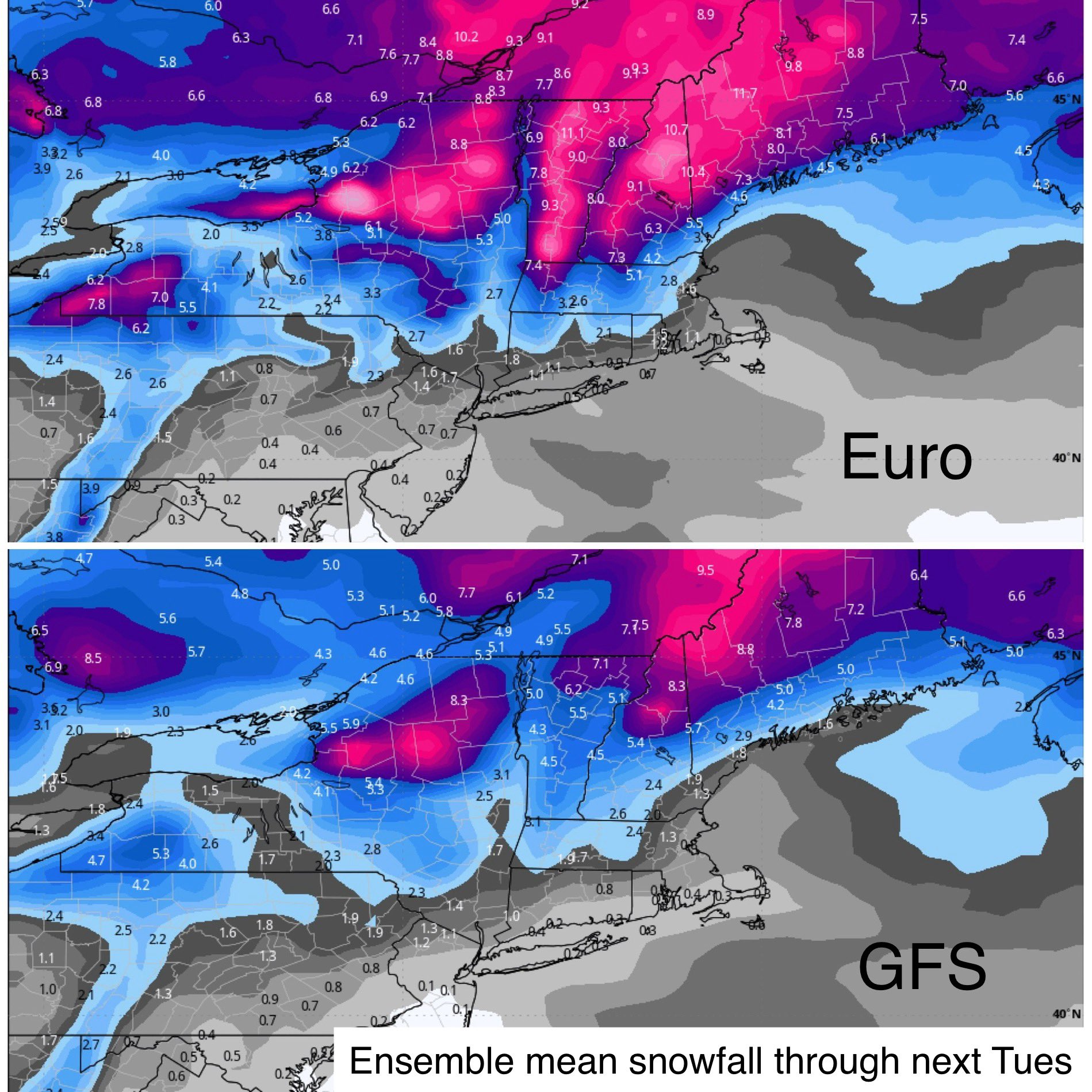
Morning fells. I hate to be the guy who's glass is half empty while others are trying to be half full but I have to argue a counter point to the optimism. My concern is that the atmosphere and set up isnt there for this one. Its starts with the MJO forcing. It's in and around phase 3 and 4 leading into this time frame neither is a cold phase in general for our region. The EPO is very strongly in a positive phase, +2-2.5 (+/-), around this time frame. The result is a mean trough ridge axis forced into a positive tilted progressive state beginning over the Pacific and extending over the entire NA continent. This looks to translate through the entire configuration of the jet stream mean pattern from WC to the EC. Im trying to find a mechanism that can buckle the jet along the EC coast, but I am just not seeing it at this point. This has to happen, (EC trough tilts towards at least neutral to slt neg before it exits the EC), to give our storm system a mechanism to draw cold air into it. Its going to be extremely difficult to get enough cold air into the system in time to make a difference with such a progressive Atlantic. Again its the mean ridge trough axis configuration, likely driven by an unfavorable MJO and EPO as stated above that is the preverbal thorn in the side or Achilles heal, despite favorable things like a positive PNA and negative NAO. Anyway its just how I see it.
Below are the euro op which has support with the ensembles at 500mbs regarding this unfavorable trough/ridge configuration. GFS Op and ensembles have similar agreement. Ill include the GEFS below the EPS. Then below that look at the upper level jet at 200mb is just screaming off the EC leading to the progressive flow. Now there is enough time between now and then for some of the drivers to evolve and perhaps change for the better, but IMHO the coastal plain should keep an extremely low expectation(ie: no white), and even folks NW should temper the expectation for now as well(ie: slight chance).


_________________
"In weather and in life, there's no winning and losing; there's only winning and learning."
WINTER 2012/2013 TOTALS 43.65"WINTER 2017/2018 TOTALS 62.85" WINTER 2022/2023 TOTALS 4.9"
WINTER 2013/2014 TOTALS 64.85"WINTER 2018/2019 TOTALS 14.25" WINTER 2023/2024 TOTALS 13.1"
WINTER 2014/2015 TOTALS 71.20"WINTER 2019/2020 TOTALS 6.35"
WINTER 2015/2016 TOTALS 35.00"WINTER 2020/2021 TOTALS 37.75"
WINTER 2016/2017 TOTALS 42.25"WINTER 2021/2022 TOTALS 31.65"

sroc4- Admin
- Posts : 8354
Reputation : 302
Join date : 2013-01-07
Location : Wading River, LI
Re: Long Range Thread 27.0
![]() by heehaw453 Wed Nov 29, 2023 8:16 am
by heehaw453 Wed Nov 29, 2023 8:16 am
Latter part of December I'd bet this works out much better for a lot of folks on this board.

heehaw453- Advanced Forecaster
- Posts : 3906
Reputation : 86
Join date : 2014-01-20
Location : Bedminster Township, PA Elevation 600' ASL
sroc4 likes this post
Re: Long Range Thread 27.0
![]() by amugs Wed Nov 29, 2023 8:25 am
by amugs Wed Nov 29, 2023 8:25 am
The PV is being stretched by mid month of DEC. If true it will do some dirty work in supplying cold air into the CONUS.

_________________
Mugs
AKA:King: Snow Weenie
Self Proclaimed
WINTER 2014-15 : 55.12" +.02 for 6 coatings (avg. 35")
WINTER 2015-16 Total - 29.8" (Avg 35")
WINTER 2016-17 : 39.5" so far
amugs- Advanced Forecaster - Mod
- Posts : 15095
Reputation : 213
Join date : 2013-01-07
Age : 54
Location : Hillsdale,NJ
sroc4 likes this post
Re: Long Range Thread 27.0
![]() by sroc4 Wed Nov 29, 2023 9:06 am
by sroc4 Wed Nov 29, 2023 9:06 am
amugs wrote:Thakns for the analysis SROC. The map I posted portended to a good possibility as the PNA was further west whch allowed for downstream adjustments. Last nights run at 0Z show the ridge rolling east, that won't cut it. Lets see what subsequent runs say.
The PV is being stretched by mid month of DEC. If true it will do some dirty work in supplying cold air into the CONUS.
Yeah Mugs, I am really excited about the LT Strat forecasts. That said like any LT potential there is still alot of uncertainty on the details of how is pans out. Potential is def there though for pretty wild end of the year into the first few weeks of next year.
_________________
"In weather and in life, there's no winning and losing; there's only winning and learning."
WINTER 2012/2013 TOTALS 43.65"WINTER 2017/2018 TOTALS 62.85" WINTER 2022/2023 TOTALS 4.9"
WINTER 2013/2014 TOTALS 64.85"WINTER 2018/2019 TOTALS 14.25" WINTER 2023/2024 TOTALS 13.1"
WINTER 2014/2015 TOTALS 71.20"WINTER 2019/2020 TOTALS 6.35"
WINTER 2015/2016 TOTALS 35.00"WINTER 2020/2021 TOTALS 37.75"
WINTER 2016/2017 TOTALS 42.25"WINTER 2021/2022 TOTALS 31.65"
sroc4- Admin
- Posts : 8354
Reputation : 302
Join date : 2013-01-07
Location : Wading River, LI
Re: Long Range Thread 27.0
![]() by amugs Wed Nov 29, 2023 10:30 am
by amugs Wed Nov 29, 2023 10:30 am
_________________
Mugs
AKA:King: Snow Weenie
Self Proclaimed
WINTER 2014-15 : 55.12" +.02 for 6 coatings (avg. 35")
WINTER 2015-16 Total - 29.8" (Avg 35")
WINTER 2016-17 : 39.5" so far
amugs- Advanced Forecaster - Mod
- Posts : 15095
Reputation : 213
Join date : 2013-01-07
Age : 54
Location : Hillsdale,NJ
sroc4 and docstox12 like this post
Re: Long Range Thread 27.0
![]() by amugs Wed Nov 29, 2023 10:33 am
by amugs Wed Nov 29, 2023 10:33 am
Its what you want to see, thermally. Followup wave. Next week. Winter may be on the doorstep of the urban corridor of the upper Mid-Atlantic and North East. pic.twitter.com/QDUmgnefto
— ContentWeatherGuy (@ContentWxGuy) November 29, 2023
_________________
Mugs
AKA:King: Snow Weenie
Self Proclaimed
WINTER 2014-15 : 55.12" +.02 for 6 coatings (avg. 35")
WINTER 2015-16 Total - 29.8" (Avg 35")
WINTER 2016-17 : 39.5" so far
amugs- Advanced Forecaster - Mod
- Posts : 15095
Reputation : 213
Join date : 2013-01-07
Age : 54
Location : Hillsdale,NJ
Re: Long Range Thread 27.0
![]() by amugs Wed Nov 29, 2023 10:41 am
by amugs Wed Nov 29, 2023 10:41 am
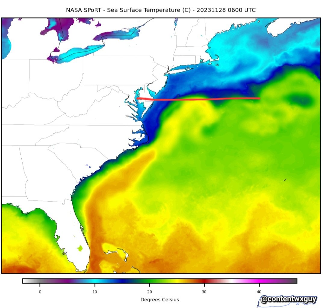
Pattern shifts east. Gulf high trends to the Atlantic while seeing its western flank eroded enabling the plucking of the sub-tropical disturbances by the Pacific mid level features. That high is instrumental in determining rain/snow lines up north via sub tropical wave tracking. pic.twitter.com/eHw2gzZ5NA
— ContentWeatherGuy (@ContentWxGuy) November 29, 2023
_________________
Mugs
AKA:King: Snow Weenie
Self Proclaimed
WINTER 2014-15 : 55.12" +.02 for 6 coatings (avg. 35")
WINTER 2015-16 Total - 29.8" (Avg 35")
WINTER 2016-17 : 39.5" so far
amugs- Advanced Forecaster - Mod
- Posts : 15095
Reputation : 213
Join date : 2013-01-07
Age : 54
Location : Hillsdale,NJ
Re: Long Range Thread 27.0
![]() by heehaw453 Wed Nov 29, 2023 11:39 am
by heehaw453 Wed Nov 29, 2023 11:39 am

heehaw453- Advanced Forecaster
- Posts : 3906
Reputation : 86
Join date : 2014-01-20
Location : Bedminster Township, PA Elevation 600' ASL
Re: Long Range Thread 27.0
![]() by aiannone Wed Nov 29, 2023 2:13 pm
by aiannone Wed Nov 29, 2023 2:13 pm
_________________
-Alex Iannone-

aiannone- Senior Enthusiast - Mod
- Posts : 4815
Reputation : 92
Join date : 2013-01-07
Location : Saint James, LI (Northwest Suffolk Co.)
amugs likes this post
Re: Long Range Thread 27.0
![]() by amugs Wed Nov 29, 2023 2:17 pm
by amugs Wed Nov 29, 2023 2:17 pm
If it does your chance of snow increase into burbs of NYC I'd say.
_________________
Mugs
AKA:King: Snow Weenie
Self Proclaimed
WINTER 2014-15 : 55.12" +.02 for 6 coatings (avg. 35")
WINTER 2015-16 Total - 29.8" (Avg 35")
WINTER 2016-17 : 39.5" so far
amugs- Advanced Forecaster - Mod
- Posts : 15095
Reputation : 213
Join date : 2013-01-07
Age : 54
Location : Hillsdale,NJ
Re: Long Range Thread 27.0
![]() by amugs Wed Nov 29, 2023 2:22 pm
by amugs Wed Nov 29, 2023 2:22 pm
aiannone wrote:12z euro was interesting for Sunday night
All 3 globals have snows into the HV, Orange County, NWNJ now. Euro has a 50/50 low that blows up and helps with a stronger NAO block drive cold air. interesting.
Only 130 hours hours out.

Going to be an interesting period. Ski resorts should be throttled for the 3 waves/storms in this next weeks period!
_________________
Mugs
AKA:King: Snow Weenie
Self Proclaimed
WINTER 2014-15 : 55.12" +.02 for 6 coatings (avg. 35")
WINTER 2015-16 Total - 29.8" (Avg 35")
WINTER 2016-17 : 39.5" so far
amugs- Advanced Forecaster - Mod
- Posts : 15095
Reputation : 213
Join date : 2013-01-07
Age : 54
Location : Hillsdale,NJ
Re: Long Range Thread 27.0
![]() by amugs Wed Nov 29, 2023 5:53 pm
by amugs Wed Nov 29, 2023 5:53 pm
Mark Adams
The pattern will be energized by these blasts. Huge amount of protons and plasma going to bombard us. Watch the storms intensify.

_________________
Mugs
AKA:King: Snow Weenie
Self Proclaimed
WINTER 2014-15 : 55.12" +.02 for 6 coatings (avg. 35")
WINTER 2015-16 Total - 29.8" (Avg 35")
WINTER 2016-17 : 39.5" so far
amugs- Advanced Forecaster - Mod
- Posts : 15095
Reputation : 213
Join date : 2013-01-07
Age : 54
Location : Hillsdale,NJ
sroc4, docstox12 and kalleg like this post
Re: Long Range Thread 27.0
![]() by amugs Thu Nov 30, 2023 8:43 am
by amugs Thu Nov 30, 2023 8:43 am

_________________
Mugs
AKA:King: Snow Weenie
Self Proclaimed
WINTER 2014-15 : 55.12" +.02 for 6 coatings (avg. 35")
WINTER 2015-16 Total - 29.8" (Avg 35")
WINTER 2016-17 : 39.5" so far
amugs- Advanced Forecaster - Mod
- Posts : 15095
Reputation : 213
Join date : 2013-01-07
Age : 54
Location : Hillsdale,NJ
Re: Long Range Thread 27.0
![]() by aiannone Thu Nov 30, 2023 9:37 am
by aiannone Thu Nov 30, 2023 9:37 am

_________________
-Alex Iannone-
aiannone- Senior Enthusiast - Mod
- Posts : 4815
Reputation : 92
Join date : 2013-01-07
Location : Saint James, LI (Northwest Suffolk Co.)
sroc4 and amugs like this post
Re: Long Range Thread 27.0
![]() by amugs Thu Nov 30, 2023 12:12 pm
by amugs Thu Nov 30, 2023 12:12 pm
BSR = Bearing Sea Rule
How the Bering Sea Rule Teleconnection [+~19 days, sweet spot Mid-West through North East region] sees the December 13 through 19 period. pic.twitter.com/aVLUnZiozI
— ContentWeatherGuy (@ContentWxGuy) November 29, 2023
_________________
Mugs
AKA:King: Snow Weenie
Self Proclaimed
WINTER 2014-15 : 55.12" +.02 for 6 coatings (avg. 35")
WINTER 2015-16 Total - 29.8" (Avg 35")
WINTER 2016-17 : 39.5" so far
amugs- Advanced Forecaster - Mod
- Posts : 15095
Reputation : 213
Join date : 2013-01-07
Age : 54
Location : Hillsdale,NJ
Page 5 of 40 • 1, 2, 3, 4, 5, 6 ... 22 ... 40 ![]()
|
|
|