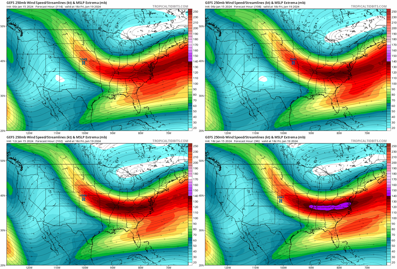
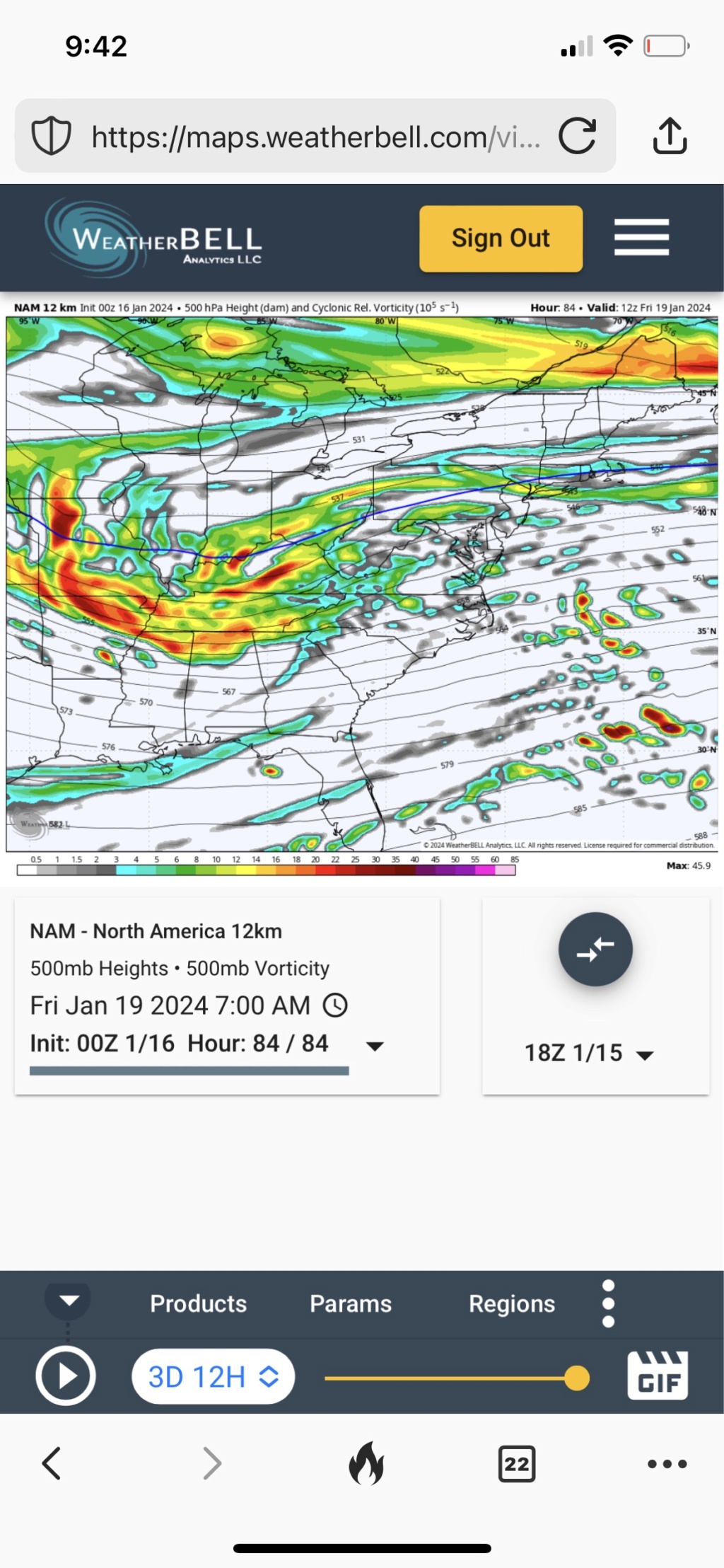
Long Range Thread 27.0
+40
Artechmetals
essexcountypete
Carvin
hyde345
kalleg
uanswer2me
billg315
Radz
crippo84
Koroptim
Wheezer
chief7
GreyBeard
CPcantmeasuresnow
dsix85
toople
phil155
algae888
deadrabbit79
HectorO
Frozen.9
MattyICE
JT33
brownie
Irish
aiannone
Dunnzoo
SENJsnowman
tomsriversnowstorm
nutleyblizzard
jmanley32
frank 638
dkodgis
docstox12
heehaw453
Frank_Wx
amugs
rb924119
weatherwatchermom
sroc4
44 posters
Page 39 of 40
Page 39 of 40 •  1 ... 21 ... 38, 39, 40
 Re: Long Range Thread 27.0
You all must realize that we have to get tomorrow system out of the way so models can then key on the next one. Same happened with tomorrows with Friday/Saturday system. There are so many moving parts and so much energy flying around the base of the PV that they cannot key in on the mid range let alone LR storms.
Lastly, NW trend has been the norm ALL winter long and why? This.
SE Atlantic Gyration - been here all winter and is locked in.
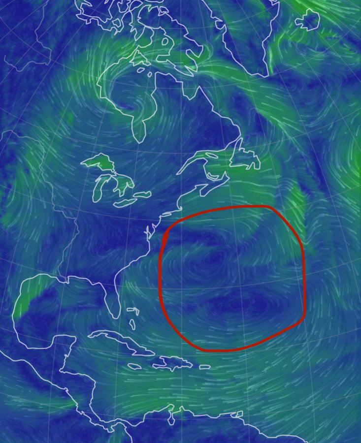
Lastly, NW trend has been the norm ALL winter long and why? This.
SE Atlantic Gyration - been here all winter and is locked in.

amugs- Advanced Forecaster - Mod

- Posts : 15095
Join date : 2013-01-07
sroc4, CPcantmeasuresnow, jmanley32 and SENJsnowman like this post
 Re: Long Range Thread 27.0
Given the recent pattern of us getting storms every Friday into Saturday I'll place my money on us getting the Friday-Saturday storm in some form. Once we get locked into one of those redundant patterns they often persist for a few weeks. This time the cold air will be abundant. Will be a question of exactly what we get.
billg315- Advanced Forecaster - Mod

- Posts : 4483
Join date : 2015-01-24
 Re: Long Range Thread 27.0
_________________
Mugs
AKA:King: Snow Weenie
Self Proclaimed
WINTER 2014-15 : 55.12" +.02 for 6 coatings (avg. 35")
WINTER 2015-16 Total - 29.8" (Avg 35")
WINTER 2016-17 : 39.5" so far

amugs- Advanced Forecaster - Mod

- Posts : 15095
Reputation : 213
Join date : 2013-01-07
Age : 54
Location : Hillsdale,NJ
Frank_Wx and kalleg like this post
 Re: Long Range Thread 27.0
_________________
"In weather and in life, there's no winning and losing; there's only winning and learning."
WINTER 2012/2013 TOTALS 43.65"WINTER 2017/2018 TOTALS 62.85" WINTER 2022/2023 TOTALS 4.9"
WINTER 2013/2014 TOTALS 64.85"WINTER 2018/2019 TOTALS 14.25" WINTER 2023/2024 TOTALS 13.1"
WINTER 2014/2015 TOTALS 71.20"WINTER 2019/2020 TOTALS 6.35"
WINTER 2015/2016 TOTALS 35.00"WINTER 2020/2021 TOTALS 37.75"
WINTER 2016/2017 TOTALS 42.25"WINTER 2021/2022 TOTALS 31.65"

sroc4- Admin

- Posts : 8354
Reputation : 302
Join date : 2013-01-07
Location : Wading River, LI
jmanley32 likes this post
 Re: Long Range Thread 27.0
D
Last edited by CPcantmeasuresnow on Mon Jan 15, 2024 11:35 pm; edited 1 time in total

CPcantmeasuresnow- Wx Statistician Guru

- Posts : 7274
Reputation : 230
Join date : 2013-01-07
Age : 103
Location : Eastern Orange County, NY
CPcantmeasuresnow likes this post
 Re: Long Range Thread 27.0
OH CANADA - just gave us a very close Mr. G.

That's exactly what we want at this range and let this one move out before we hone in on Friday starting at 12Z tomorrow.

That's exactly what we want at this range and let this one move out before we hone in on Friday starting at 12Z tomorrow.
_________________
Mugs
AKA:King: Snow Weenie
Self Proclaimed
WINTER 2014-15 : 55.12" +.02 for 6 coatings (avg. 35")
WINTER 2015-16 Total - 29.8" (Avg 35")
WINTER 2016-17 : 39.5" so far

amugs- Advanced Forecaster - Mod

- Posts : 15095
Reputation : 213
Join date : 2013-01-07
Age : 54
Location : Hillsdale,NJ
 Re: Long Range Thread 27.0
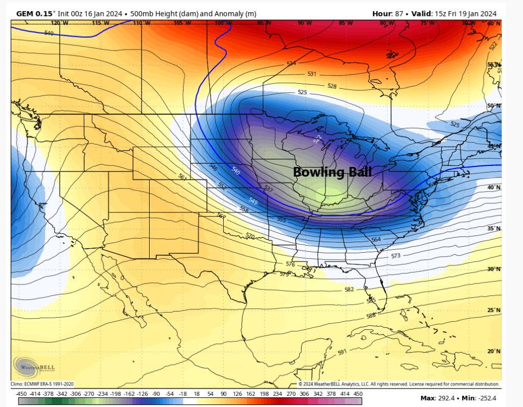
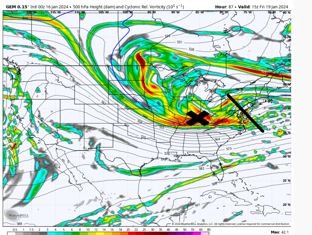
The Canadian is showing what I believe is the best chance for something more sig Friday. More consolidated s/w energy and because of it the 500mb trough turns negative as it hits the coast. It's the ULL bowling ball rolling underneath you that works. Unfortunately Euro/GFS don't agree yet and have ULL energy spread out which looks more like spaghetti than a meatball. So then the surface low is weak and just meanders a bit. Until agreement comes in I would be cautious about getting hopes up. They'll be some snow, but how much depends on consolidation...


heehaw453- Advanced Forecaster

- Posts : 3906
Reputation : 86
Join date : 2014-01-20
Location : Bedminster Township, PA Elevation 600' ASL
Frank_Wx likes this post
 Re: Long Range Thread 27.0
I think this one coming on Friday would be more on the order of 3-6 4-8 around nyc metro
Carvin- Posts : 44
Reputation : 2
Join date : 2019-01-09
 Re: Long Range Thread 27.0
I hope so! Where we at with this now?

jmanley32- Senior Enthusiast

- Posts : 20535
Reputation : 108
Join date : 2013-12-12
Age : 43
Location : Yonkers, NY
 Re: Long Range Thread 27.0
Very little global Op or Ens support for Friday. NAM and RGEM say maybe. Today would be the day as this current storm clears out to see positive trends if they are going to start at all
MattyICE- Advanced Forecaster

- Posts : 249
Reputation : 6
Join date : 2017-11-10
Age : 38
Location : Clifton, NJ (Eastern Passaic County)
 Re: Long Range Thread 27.0
heehaw453 wrote:The Canadian is showing what I believe is the best chance for something more sig Friday. More consolidated s/w energy and because of it the 500mb trough turns negative as it hits the coast. It's the ULL bowling ball rolling underneath you that works. Unfortunately Euro/GFS don't agree yet and have ULL energy spread out which looks more like spaghetti than a meatball. So then the surface low is weak and just meanders a bit. Until agreement comes in I would be cautious about getting hopes up. They'll be some snow, but how much depends on consolidation...
Impressed with the spaghetti and meatball analogy
_________________
_______________________________________________________________________________________________________
CLICK HERE to view NJ Strong Snowstorm Classifications
heehaw453 likes this post
 Re: Long Range Thread 27.0
MattyICE wrote:Very little global Op or Ens support for Friday. NAM and RGEM say maybe. Today would be the day as this current storm clears out to see positive trends if they are going to start at all
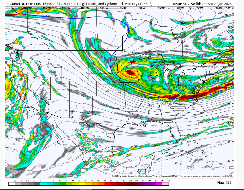
06Z Euro. It's not far off from something bigger here. A bit more consolidation and digging of the trough, then you'd have something as the trough would go negative and capture the midlevels.
heehaw453- Advanced Forecaster

- Posts : 3906
Reputation : 86
Join date : 2014-01-20
Location : Bedminster Township, PA Elevation 600' ASL

Irish- Pro Enthusiast

- Posts : 788
Reputation : 19
Join date : 2019-01-16
Age : 45
Location : Old Bridge, NJ
heehaw453- Advanced Forecaster

- Posts : 3906
Reputation : 86
Join date : 2014-01-20
Location : Bedminster Township, PA Elevation 600' ASL
jmanley32 and Irish like this post
 Re: Long Range Thread 27.0
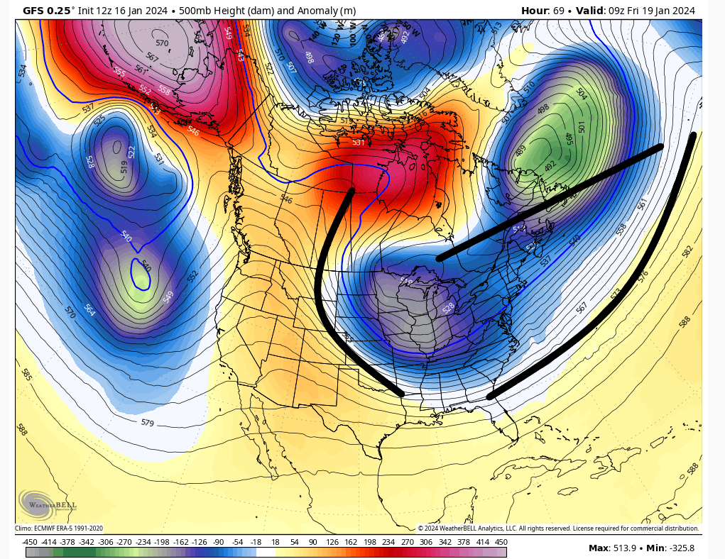
12Z GFS closer still. It seems the h5 is going squeeze the energy IMO. You have western ridge, Atlantic ridge, 50/50 trough. Where can this go in a hurry? If the phasing is right this will trend a good way IMO.
edit: A little better spacing on the 50/50 would give it more room to breathe too. That might be the key to this actually.
edit: A little better spacing on the 50/50 would give it more room to breathe too. That might be the key to this actually.

heehaw453- Advanced Forecaster

- Posts : 3906
Reputation : 86
Join date : 2014-01-20
Location : Bedminster Township, PA Elevation 600' ASL
kalleg and MattyICE like this post
 Re: Long Range Thread 27.0
GEM holds for the most part. Conts to insist on a well organized storm. How close to the coast can it get? CMC and RGEM did a great job with todays system.


_________________
"In weather and in life, there's no winning and losing; there's only winning and learning."
WINTER 2012/2013 TOTALS 43.65"WINTER 2017/2018 TOTALS 62.85" WINTER 2022/2023 TOTALS 4.9"
WINTER 2013/2014 TOTALS 64.85"WINTER 2018/2019 TOTALS 14.25" WINTER 2023/2024 TOTALS 13.1"
WINTER 2014/2015 TOTALS 71.20"WINTER 2019/2020 TOTALS 6.35"
WINTER 2015/2016 TOTALS 35.00"WINTER 2020/2021 TOTALS 37.75"
WINTER 2016/2017 TOTALS 42.25"WINTER 2021/2022 TOTALS 31.65"

sroc4- Admin

- Posts : 8354
Reputation : 302
Join date : 2013-01-07
Location : Wading River, LI
Frank_Wx, kalleg and jmanley32 like this post
 Re: Long Range Thread 27.0
I mentioned an inverted trough the other day
Starting to think that will be the outcome here
But threat of a bigger storm remains. Won’t take much as Heehaw points out
Starting to think that will be the outcome here
But threat of a bigger storm remains. Won’t take much as Heehaw points out
_________________
_______________________________________________________________________________________________________
CLICK HERE to view NJ Strong Snowstorm Classifications
kalleg and jmanley32 like this post
 Re: Long Range Thread 27.0
hey scott back from my banishment to banter lol. Does thishave a much higher potential thsn today?sroc4 wrote:GEM holds for the most part. Conts to insist on a well organized storm. How close to the coast can it get? CMC and RGEM did a great job with todays system.

jmanley32- Senior Enthusiast

- Posts : 20535
Reputation : 108
Join date : 2013-12-12
Age : 43
Location : Yonkers, NY
 Re: Long Range Thread 27.0
You can add the 12Z Ukie to the more aggressive camp too. Again at D3 operational runs should start adjusting soon. I'd be skeptical of any surface maps that show a benign event for an ULL sliding underneath and tilting its 500mb trough negative before hitting the coast. Capturing midlevel energy close enough to coast can do wonders.


heehaw453- Advanced Forecaster

- Posts : 3906
Reputation : 86
Join date : 2014-01-20
Location : Bedminster Township, PA Elevation 600' ASL
 Re: Long Range Thread 27.0
Do inverted troughs mean more or less of a likelihood of a powerful storm?Frank_Wx wrote:I mentioned an inverted trough the other day
Starting to think that will be the outcome here
But threat of a bigger storm remains. Won’t take much as Heehaw points out

Irish- Pro Enthusiast

- Posts : 788
Reputation : 19
Join date : 2019-01-16
Age : 45
Location : Old Bridge, NJ
 Re: Long Range Thread 27.0
Irish wrote:Do inverted troughs mean more or less of a likelihood of a powerful storm?Frank_Wx wrote:I mentioned an inverted trough the other day
Starting to think that will be the outcome here
But threat of a bigger storm remains. Won’t take much as Heehaw points out
If you're under the banding that occurs via an inverted trough you can do very well. But they are very hard to predict exact locations so nowcasting is often needed. And its much less wide spread for sure.
_________________
"In weather and in life, there's no winning and losing; there's only winning and learning."
WINTER 2012/2013 TOTALS 43.65"WINTER 2017/2018 TOTALS 62.85" WINTER 2022/2023 TOTALS 4.9"
WINTER 2013/2014 TOTALS 64.85"WINTER 2018/2019 TOTALS 14.25" WINTER 2023/2024 TOTALS 13.1"
WINTER 2014/2015 TOTALS 71.20"WINTER 2019/2020 TOTALS 6.35"
WINTER 2015/2016 TOTALS 35.00"WINTER 2020/2021 TOTALS 37.75"
WINTER 2016/2017 TOTALS 42.25"WINTER 2021/2022 TOTALS 31.65"

sroc4- Admin

- Posts : 8354
Reputation : 302
Join date : 2013-01-07
Location : Wading River, LI
Grselig and weatherwatchermom like this post
 Re: Long Range Thread 27.0
I'm just hoping for very little or a later start Friday (in the afternoon). Mom has a flight out of Newark to Florida at 2:30. Can't have my 88 yo mom sitting in the airport all day hoping to get out! It can snow all it wants after 2 pm!
_________________
Janet
Snowfall winter of 2023-2024 17.5"
Snowfall winter of 2022-2023 6.0"
Snowfall winter of 2021-2022 17.6" 1" sleet 2/25/22
Snowfall winter of 2020-2021 51.1"
Snowfall winter of 2019-2020 8.5"
Snowfall winter of 2018-2019 25.1"
Snowfall winter of 2017-2018 51.9"
Snowfall winter of 2016-2017 45.6"
Snowfall winter of 2015-2016 29.5"
Snowfall winter of 2014-2015 50.55"
Snowfall winter of 2013-2014 66.5"
Dunnzoo- Senior Enthusiast - Mod

- Posts : 4905
Reputation : 68
Join date : 2013-01-11
Age : 62
Location : Westwood, NJ
weatherwatchermom likes this post
 Re: Long Range Thread 27.0
Ugh, that's rough. So, we'd much rather not have an inverted trough.sroc4 wrote:Irish wrote:Do inverted troughs mean more or less of a likelihood of a powerful storm?Frank_Wx wrote:I mentioned an inverted trough the other day
Starting to think that will be the outcome here
But threat of a bigger storm remains. Won’t take much as Heehaw points out
If you're under the banding that occurs via an inverted trough you can do very well. But they are very hard to predict exact locations so nowcasting is often needed. And its much less wide spread for sure.

Irish- Pro Enthusiast

- Posts : 788
Reputation : 19
Join date : 2019-01-16
Age : 45
Location : Old Bridge, NJ
 Re: Long Range Thread 27.0
The 12Z Euro is sooo close to being so much better. If this ULL just gets a better phase/consolidation it'd be game on as the trough would tip more negative and capture the mid-level energy in time for a good event. If we miss by an inch I'd rather miss by a mile.
Mid levels powder keg

ULL just a hair too disjoint as it's approaching the coast
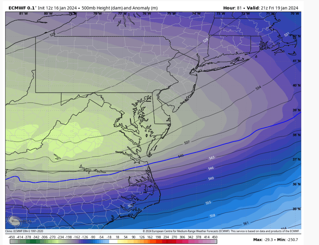
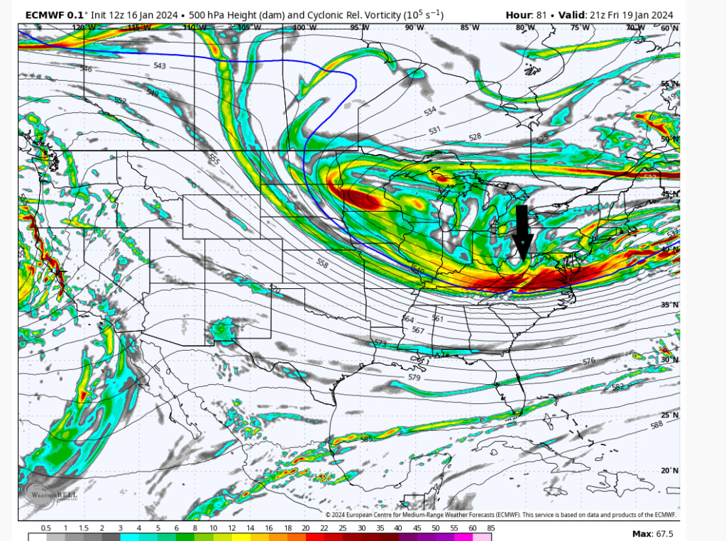
Mid levels powder keg

ULL just a hair too disjoint as it's approaching the coast


heehaw453- Advanced Forecaster

- Posts : 3906
Reputation : 86
Join date : 2014-01-20
Location : Bedminster Township, PA Elevation 600' ASL
 Re: Long Range Thread 27.0
heehaw453 wrote:The 12Z Euro is sooo close to being so much better. If this ULL just gets a better phase/consolidation it'd be game on as the trough would tip more negative and capture the mid-level energy in time for a good event. If we miss by an inch I'd rather miss by a mile.
Mid levels powder keg
ULL just a hair too disjoint as it's approaching the coast
Remember Euro likes to walk itself back to its final soln. I like the steps at H5 and the surface. Last 4 consecutive runs the surface low has ticked back NW each time.
_________________
"In weather and in life, there's no winning and losing; there's only winning and learning."
WINTER 2012/2013 TOTALS 43.65"WINTER 2017/2018 TOTALS 62.85" WINTER 2022/2023 TOTALS 4.9"
WINTER 2013/2014 TOTALS 64.85"WINTER 2018/2019 TOTALS 14.25" WINTER 2023/2024 TOTALS 13.1"
WINTER 2014/2015 TOTALS 71.20"WINTER 2019/2020 TOTALS 6.35"
WINTER 2015/2016 TOTALS 35.00"WINTER 2020/2021 TOTALS 37.75"
WINTER 2016/2017 TOTALS 42.25"WINTER 2021/2022 TOTALS 31.65"

sroc4- Admin

- Posts : 8354
Reputation : 302
Join date : 2013-01-07
Location : Wading River, LI
 Re: Long Range Thread 27.0
Irish wrote:Ugh, that's rough. So, we'd much rather not have an inverted trough.sroc4 wrote:Irish wrote:Do inverted troughs mean more or less of a likelihood of a powerful storm?Frank_Wx wrote:I mentioned an inverted trough the other day
Starting to think that will be the outcome here
But threat of a bigger storm remains. Won’t take much as Heehaw points out
If you're under the banding that occurs via an inverted trough you can do very well. But they are very hard to predict exact locations so nowcasting is often needed. And its much less wide spread for sure.
We could have both!
_________________
"In weather and in life, there's no winning and losing; there's only winning and learning."
WINTER 2012/2013 TOTALS 43.65"WINTER 2017/2018 TOTALS 62.85" WINTER 2022/2023 TOTALS 4.9"
WINTER 2013/2014 TOTALS 64.85"WINTER 2018/2019 TOTALS 14.25" WINTER 2023/2024 TOTALS 13.1"
WINTER 2014/2015 TOTALS 71.20"WINTER 2019/2020 TOTALS 6.35"
WINTER 2015/2016 TOTALS 35.00"WINTER 2020/2021 TOTALS 37.75"
WINTER 2016/2017 TOTALS 42.25"WINTER 2021/2022 TOTALS 31.65"

sroc4- Admin

- Posts : 8354
Reputation : 302
Join date : 2013-01-07
Location : Wading River, LI
Irish likes this post
 Re: Long Range Thread 27.0
Every model has a minimum snow accumulation of 1” for Friday. The current max depending on the model is about 5”. If the trends continue at 500mb, these numbers will go way up.
_________________
_______________________________________________________________________________________________________
CLICK HERE to view NJ Strong Snowstorm Classifications
docstox12, 1190ftalt and SENJsnowman like this post
Page 39 of 40 •  1 ... 21 ... 38, 39, 40
Page 39 of 40
Permissions in this forum:
You cannot reply to topics in this forum|
|
|

 Home
Home