Long Range Thread 27.0
Page 38 of 40 •  1 ... 20 ... 37, 38, 39, 40
 Re: Long Range Thread 27.0
dkodgis- Senior Enthusiast

- Posts : 2560
Join date : 2013-12-29
jmanley32 likes this post
 Re: Long Range Thread 27.0
heehaw453- Advanced Forecaster

- Posts : 3906
Join date : 2014-01-20
sroc4 likes this post
 Re: Long Range Thread 27.0

Irish- Pro Enthusiast

- Posts : 788
Reputation : 19
Join date : 2019-01-16
Age : 45
Location : Old Bridge, NJ
jmanley32 likes this post
 Re: Long Range Thread 27.0
Irish wrote:I'm reading that next Friday's event is likely much stronger than Monday into Tuesday's.
Synoptically it has way more upside than Tuesday.
heehaw453- Advanced Forecaster

- Posts : 3906
Reputation : 86
Join date : 2014-01-20
Location : Bedminster Township, PA Elevation 600' ASL
Irish likes this post
 Re: Long Range Thread 27.0
Koroptim- Posts : 29
Reputation : 0
Join date : 2013-01-16
CPcantmeasuresnow, oldtimer, mmanisca, brownie, weatherwatchermom and Irish like this post
 Re: Long Range Thread 27.0
Koroptim wrote:I appreciate everyone’s efforts on this board, but am officially giving up on this winter and no longer paying attention to anything outside of the accuweather app. I cannot stand squabbling over nuisance 2 inch snows and chasing day 10 opportunities. I’d rather be surprised with anything that happens than torturing myself for another two months like the past few years. Good luck to all
thanks but the board IMO is for learning and respectful disagreements foster that. Frustrations over futility the last 2 years is absolutely understandable. Everyone should be skeptical of big snows until you see it pile up in your back yard.
heehaw453- Advanced Forecaster

- Posts : 3906
Reputation : 86
Join date : 2014-01-20
Location : Bedminster Township, PA Elevation 600' ASL
sroc4, docstox12, CPcantmeasuresnow, kalleg, dsvinos and weatherwatchermom like this post
 Re: Long Range Thread 27.0
MattyICE- Advanced Forecaster

- Posts : 249
Reputation : 6
Join date : 2017-11-10
Age : 38
Location : Clifton, NJ (Eastern Passaic County)
Frank_Wx, heehaw453 and SENJsnowman like this post
 Re: Long Range Thread 27.0
MattyICE wrote:Agree with a lot of the ideas here. This really can’t be more than an inch or two along and SE of 95. The colder solutions go hand in hand with being weaker/ more progressive and thus, less qpf. As Hee indicated, things can amp, but if they do the increase in QPF ups things mostly NW of 95 bringing in mixing to 95. If there were good confluence trending better in time at the same time as an amped trend then we’d be talking a different story. Just don’t see that setup here - kind of frustrating that the wish for colder air in this case also means less snow.
Depends on when the enhancement comes. Once it’s past Montauk and the cape winds shift and the air to the north is plenty cold.
_________________
"In weather and in life, there's no winning and losing; there's only winning and learning."
WINTER 2012/2013 TOTALS 43.65"WINTER 2017/2018 TOTALS 62.85" WINTER 2022/2023 TOTALS 4.9"
WINTER 2013/2014 TOTALS 64.85"WINTER 2018/2019 TOTALS 14.25" WINTER 2023/2024 TOTALS 13.1"
WINTER 2014/2015 TOTALS 71.20"WINTER 2019/2020 TOTALS 6.35"
WINTER 2015/2016 TOTALS 35.00"WINTER 2020/2021 TOTALS 37.75"
WINTER 2016/2017 TOTALS 42.25"WINTER 2021/2022 TOTALS 31.65"

sroc4- Admin

- Posts : 8354
Reputation : 302
Join date : 2013-01-07
Location : Wading River, LI
 Re: Long Range Thread 27.0
sroc4 wrote:MattyICE wrote:Agree with a lot of the ideas here. This really can’t be more than an inch or two along and SE of 95. The colder solutions go hand in hand with being weaker/ more progressive and thus, less qpf. As Hee indicated, things can amp, but if they do the increase in QPF ups things mostly NW of 95 bringing in mixing to 95. If there were good confluence trending better in time at the same time as an amped trend then we’d be talking a different story. Just don’t see that setup here - kind of frustrating that the wish for colder air in this case also means less snow.
Depends on when the enhancement comes. Once it’s past Montauk and the cape winds shift and the air to the north is plenty cold.
Totally true. I just think that happens too late for most here, but would be thrilled to be wrong!
MattyICE- Advanced Forecaster

- Posts : 249
Reputation : 6
Join date : 2017-11-10
Age : 38
Location : Clifton, NJ (Eastern Passaic County)
 Re: Long Range Thread 27.0
Koroptim wrote:I appreciate everyone’s efforts on this board, but am officially giving up on this winter and no longer paying attention to anything outside of the accuweather app. I cannot stand squabbling over nuisance 2 inch snows and chasing day 10 opportunities. I’d rather be surprised with anything that happens than torturing myself for another two months like the past few years. Good luck to all
The only ones squabbling over 2” are those who whine that it’s not 12” in their back yard. I swear people see one model run showing 12” in a snowmap; then turn tail if it’s anything but. Like heehaw noted in his response most of what we do here is about the thrill of the tracking, learning about how it all works, and the comradery of it all. The end result is only a small piece of it. At least for me. Of course we all want the goods. But it is what it is. 2” or 12” I love when it snows. If you can’t handle the discussion about what could be in the 10day because of the disappointment of not getting what you want more times than not I certainly understand that. To each his and her own.
If anyone cares to respond to this please do so in banter where Jon now lives.
_________________
"In weather and in life, there's no winning and losing; there's only winning and learning."
WINTER 2012/2013 TOTALS 43.65"WINTER 2017/2018 TOTALS 62.85" WINTER 2022/2023 TOTALS 4.9"
WINTER 2013/2014 TOTALS 64.85"WINTER 2018/2019 TOTALS 14.25" WINTER 2023/2024 TOTALS 13.1"
WINTER 2014/2015 TOTALS 71.20"WINTER 2019/2020 TOTALS 6.35"
WINTER 2015/2016 TOTALS 35.00"WINTER 2020/2021 TOTALS 37.75"
WINTER 2016/2017 TOTALS 42.25"WINTER 2021/2022 TOTALS 31.65"

sroc4- Admin

- Posts : 8354
Reputation : 302
Join date : 2013-01-07
Location : Wading River, LI
hyde345, Sparky Sparticles and JT33 like this post
SENJsnowman- Senior Enthusiast

- Posts : 1189
Reputation : 61
Join date : 2017-01-06
Age : 51
Location : Bayville, NJ
kalleg, jmanley32, heehaw453 and Irish like this post
 Re: Long Range Thread 27.0
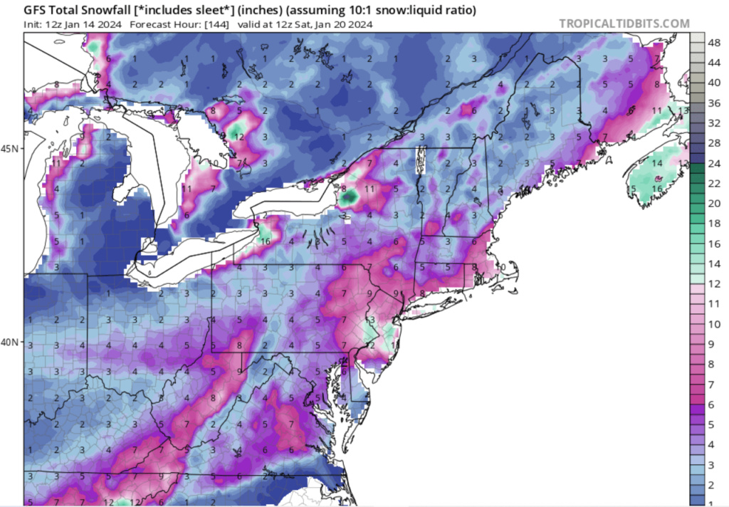
SENJsnowman wrote:Today's 12z GFS, total snowfall forecast through Saturday early morning. I would put the chances of this significantly materializing at 30-35% right now. But wow, now that I think about it, that % really does stoke my fire, but that's just me...
For right now, I'm just here to Track!
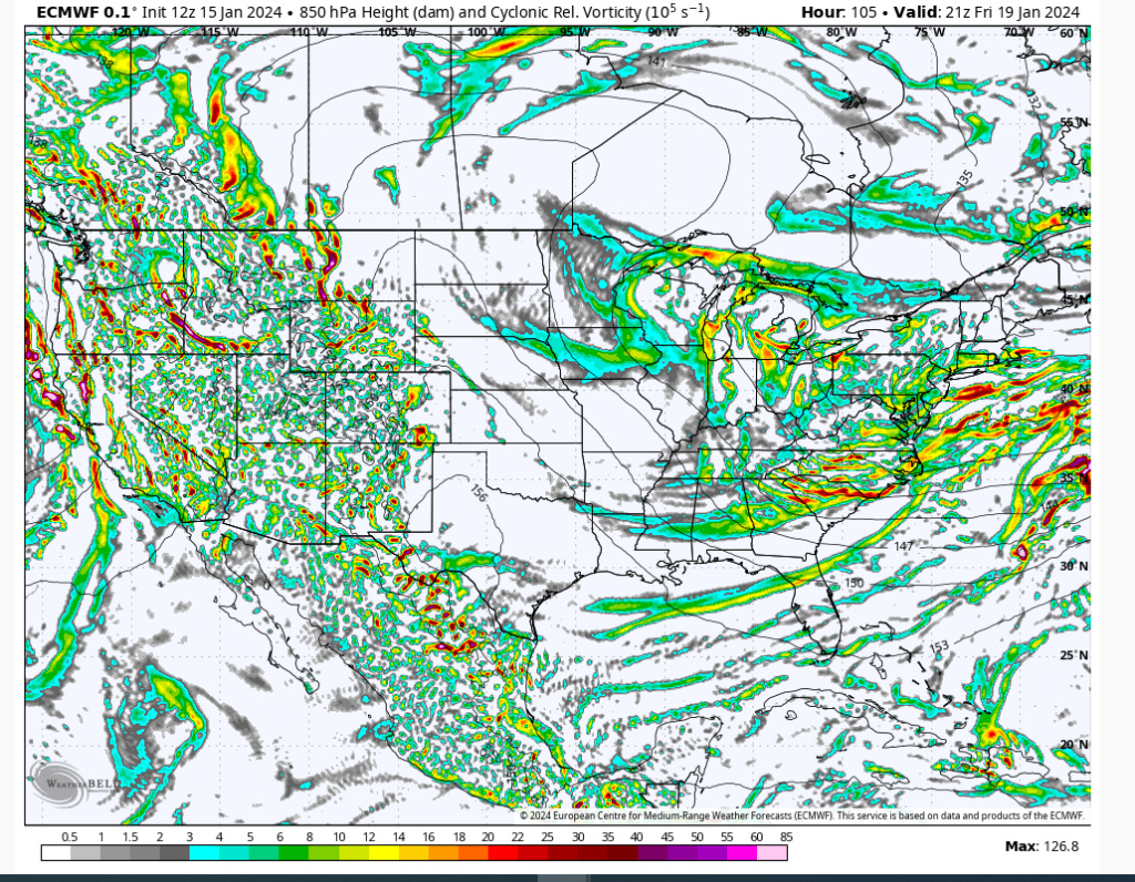
12Z Euro went a bit ballistic similar to what 12Z GFS showed. 5 Days out lots can change, but synoptically it has a chance if the trough can dig enough. The Atlantic bottleneck is the key.
heehaw453- Advanced Forecaster

- Posts : 3906
Reputation : 86
Join date : 2014-01-20
Location : Bedminster Township, PA Elevation 600' ASL
SENJsnowman and MattyICE like this post
heehaw453- Advanced Forecaster

- Posts : 3906
Reputation : 86
Join date : 2014-01-20
Location : Bedminster Township, PA Elevation 600' ASL
 Re: Long Range Thread 27.0
_________________
_______________________________________________________________________________________________________
CLICK HERE to view NJ Strong Snowstorm Classifications
 Re: Long Range Thread 27.0
you go say that and not show a snow map? lol, pleaze post. Just for fun or in banter.heehaw453 wrote:SENJsnowman wrote:Today's 12z GFS, total snowfall forecast through Saturday early morning. I would put the chances of this significantly materializing at 30-35% right now. But wow, now that I think about it, that % really does stoke my fire, but that's just me...
For right now, I'm just here to Track!
12Z Euro went a bit ballistic similar to what 12Z GFS showed. 5 Days out lots can change, but synoptically it has a chance if the trough can dig enough. The Atlantic bottleneck is the key.

jmanley32- Senior Enthusiast

- Posts : 20535
Reputation : 108
Join date : 2013-12-12
Age : 43
Location : Yonkers, NY
 Re: Long Range Thread 27.0
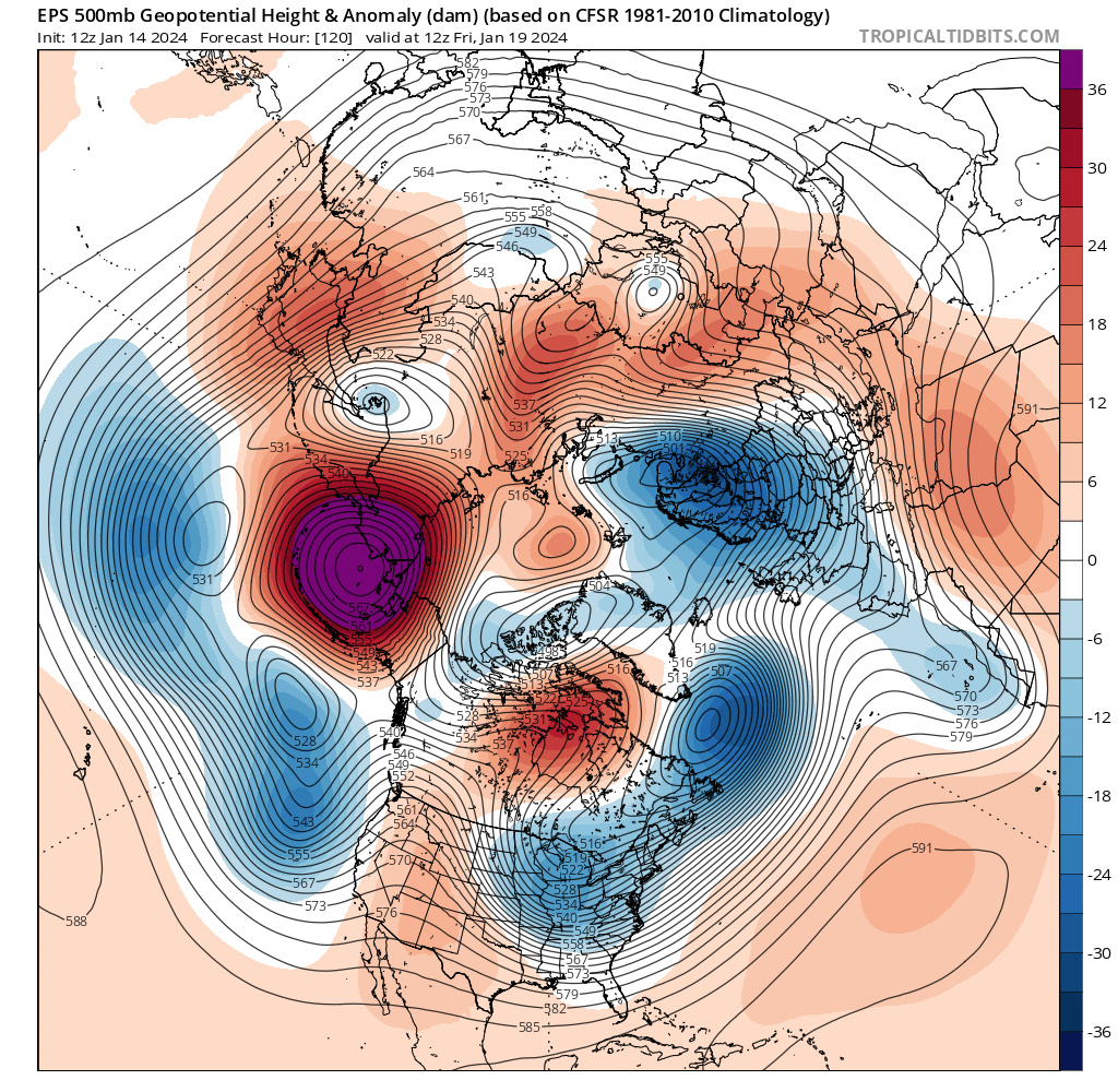
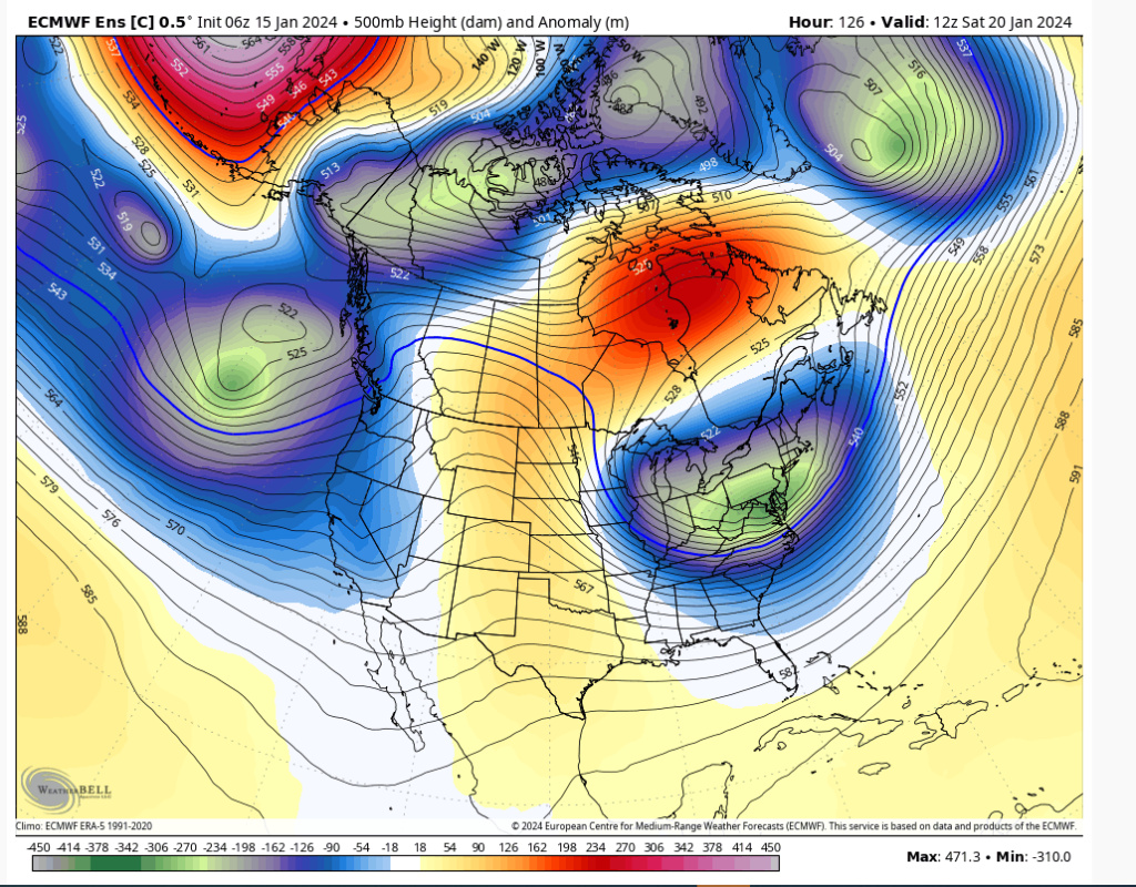
EPS H5 valid Friday morning. Signature +PNA allows pacific energy to dive into the central US. The million dollar question will be if we can get the phase to happen with the northern branch. We have a piece of the Polar Vortex stationed in southern Canada. We need to see if we can get it to phase (or eject a piece of northern stream energy). I would have liked to see more of a -NAO in this setup, but this remains a pattern that can absolutely produce if the pieces come together.
_________________
_______________________________________________________________________________________________________
CLICK HERE to view NJ Strong Snowstorm Classifications
 Re: Long Range Thread 27.0
heehaw453- Advanced Forecaster

- Posts : 3906
Reputation : 86
Join date : 2014-01-20
Location : Bedminster Township, PA Elevation 600' ASL
 Re: Long Range Thread 27.0
SENJsnowman wrote:Today's 12z GFS, total snowfall forecast through Saturday early morning. I would put the chances of this significantly materializing at 30-35% right now. But wow, now that I think about it, that % really does stoke my fire, but that's just me...
For right now, I'm just here to Track!
Would like to see this without tonight and tomorrows totals included. Would still be a good hit, not quite as dramatic.

CPcantmeasuresnow- Wx Statistician Guru

- Posts : 7274
Reputation : 230
Join date : 2013-01-07
Age : 103
Location : Eastern Orange County, NY
 Re: Long Range Thread 27.0
heehaw453- Advanced Forecaster

- Posts : 3906
Reputation : 86
Join date : 2014-01-20
Location : Bedminster Township, PA Elevation 600' ASL
 Re: Long Range Thread 27.0
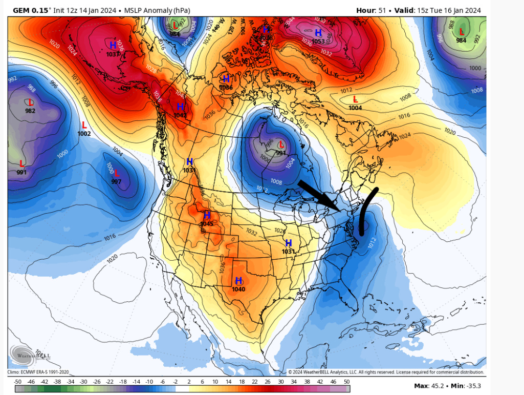
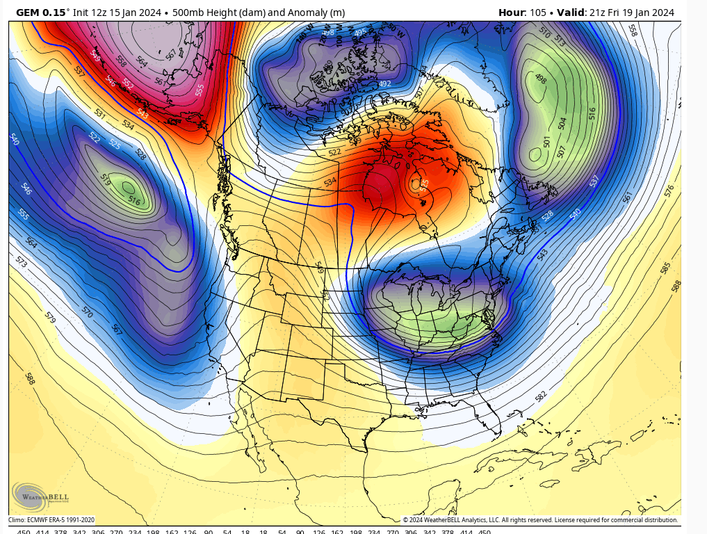
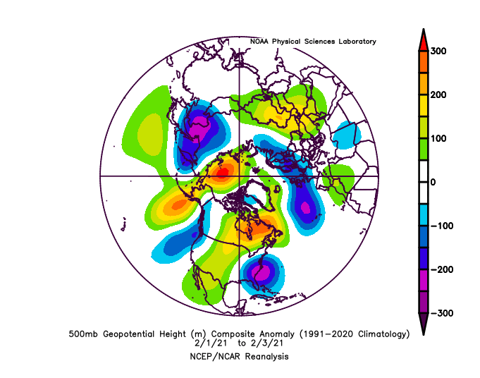
heehaw453 wrote:12Z Canadian GEM h5 works for me. The ULL getting shoved underneath and hitting an Atlantic bottleneck. These kinds of setups can be very surprising upside. Not exactly same but the bottom h5 is February 1-3 2021 that dropped 18" in Central Park. Not saying that is going to happen here, but this favors some snowfall IMO.
I like where we are at for Fridays storm. A tad SE but the trend seems to be to bring it back NW a little as we get inside 3days. I love that there is a really nice HP with this one at least as currently modeled.
_________________
"In weather and in life, there's no winning and losing; there's only winning and learning."
WINTER 2012/2013 TOTALS 43.65"WINTER 2017/2018 TOTALS 62.85" WINTER 2022/2023 TOTALS 4.9"
WINTER 2013/2014 TOTALS 64.85"WINTER 2018/2019 TOTALS 14.25" WINTER 2023/2024 TOTALS 13.1"
WINTER 2014/2015 TOTALS 71.20"WINTER 2019/2020 TOTALS 6.35"
WINTER 2015/2016 TOTALS 35.00"WINTER 2020/2021 TOTALS 37.75"
WINTER 2016/2017 TOTALS 42.25"WINTER 2021/2022 TOTALS 31.65"

sroc4- Admin

- Posts : 8354
Reputation : 302
Join date : 2013-01-07
Location : Wading River, LI
docstox12, CPcantmeasuresnow and jmanley32 like this post
heehaw453- Advanced Forecaster

- Posts : 3906
Reputation : 86
Join date : 2014-01-20
Location : Bedminster Township, PA Elevation 600' ASL
CPcantmeasuresnow likes this post
 Re: Long Range Thread 27.0
SENJsnowman- Senior Enthusiast

- Posts : 1189
Reputation : 61
Join date : 2017-01-06
Age : 51
Location : Bayville, NJ
 Re: Long Range Thread 27.0
SENJsnowman wrote:HeeHaw, on behalf of myself and my fellow Coasties, any early concerns for a tucked track or warmer levels indicated?
Synoptically this has the ingredients for a sig event right to the beaches. You have fresh cold air being pumped in by a strong H to the north and the blocked up Atlantic. Enough ridging in the west to make a digging trough feasible. But I'm not all in yet because I need to see the trough dig and tilt negative consistently run2run. If that happens it's game on especially in your area.
heehaw453- Advanced Forecaster

- Posts : 3906
Reputation : 86
Join date : 2014-01-20
Location : Bedminster Township, PA Elevation 600' ASL
 Re: Long Range Thread 27.0
heehaw453 wrote:SENJsnowman wrote:HeeHaw, on behalf of myself and my fellow Coasties, any early concerns for a tucked track or warmer levels indicated?
Synoptically this has the ingredients for an sig event right to the beaches. You have fresh cold air being pumped in by a strong H to the north and the blocked up Atlantic. Enough ridging in the west to make a digging trough feasible. But I'm not all in yet because I need to see the trough dig and tilt negative consistently run2run. If that happens it's game on especially in your area.


SENJsnowman- Senior Enthusiast

- Posts : 1189
Reputation : 61
Join date : 2017-01-06
Age : 51
Location : Bayville, NJ
 Re: Long Range Thread 27.0

Because of how “blocky” the North Atlantic into Greenland is, the initial Pacific energy hits a brick wall once it reaches the east coast. This allows a secondary piece of pacific energy to catch up to it and form a deep trough over the eastern US. What’s missing is the phase with the northern stream, but you can see it’s close and the pieces are all there. I feel strongly that the PNA and EPO ridges will work in our favor and eventually show the phase we need. I think we need to give it to tomorrow night or Wednesday. Let’s see
_________________
_______________________________________________________________________________________________________
CLICK HERE to view NJ Strong Snowstorm Classifications
docstox12, CPcantmeasuresnow, kalleg, crippo84, essexcountypete, jmanley32, heehaw453 and like this post
 Re: Long Range Thread 27.0
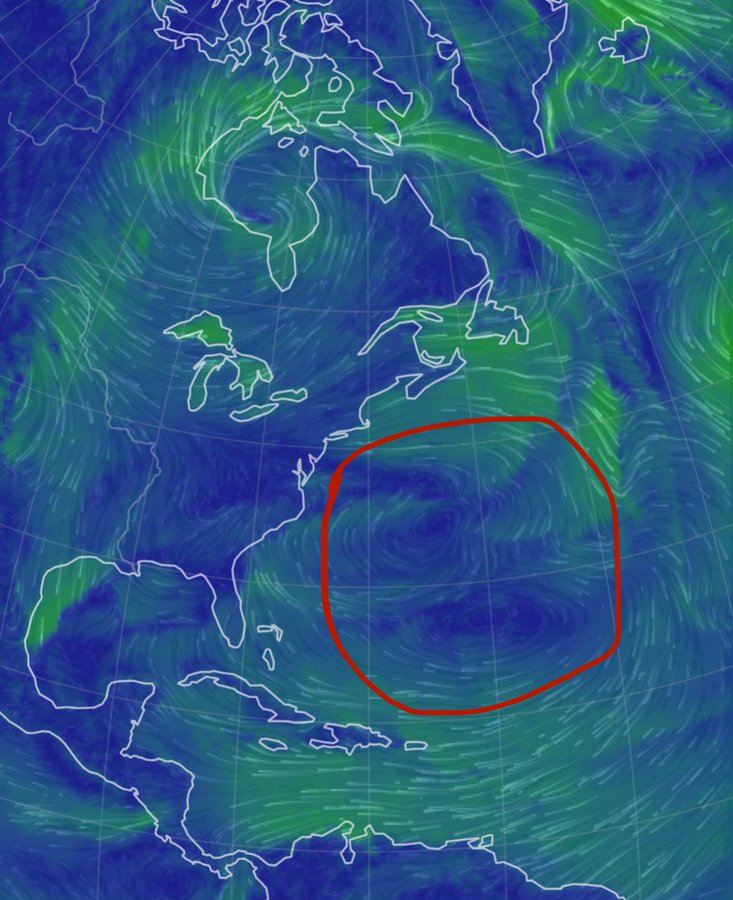
Lastly, NW trend has been the norm ALL winter long and why? This.
SE Atlantic Gyration - been here all winter and is locked in.
_________________
Mugs
AKA:King: Snow Weenie
Self Proclaimed
WINTER 2014-15 : 55.12" +.02 for 6 coatings (avg. 35")
WINTER 2015-16 Total - 29.8" (Avg 35")
WINTER 2016-17 : 39.5" so far

amugs- Advanced Forecaster - Mod

- Posts : 15095
Reputation : 213
Join date : 2013-01-07
Age : 54
Location : Hillsdale,NJ
sroc4, CPcantmeasuresnow, jmanley32 and SENJsnowman like this post
 Re: Long Range Thread 27.0

billg315- Advanced Forecaster - Mod

- Posts : 4483
Reputation : 185
Join date : 2015-01-24
Age : 50
Location : Flemington, NJ
Page 38 of 40 •  1 ... 20 ... 37, 38, 39, 40
|
|
|

 Home
Home