JAN 6th-7th Storm Thread I
+22
Coachgriff
CPcantmeasuresnow
phil155
docstox12
Artechmetals
Dunnzoo
DAYBLAZER
sroc4
frank 638
billg315
Irish
tomsriversnowstorm
dsix85
aiannone
amugs
SENJsnowman
rb924119
heehaw453
nutleyblizzard
jmanley32
dkodgis
Frank_Wx
26 posters
Page 5 of 16
Page 5 of 16 •  1, 2, 3, 4, 5, 6 ... 10 ... 16
 Re: JAN 6th-7th Storm Thread I
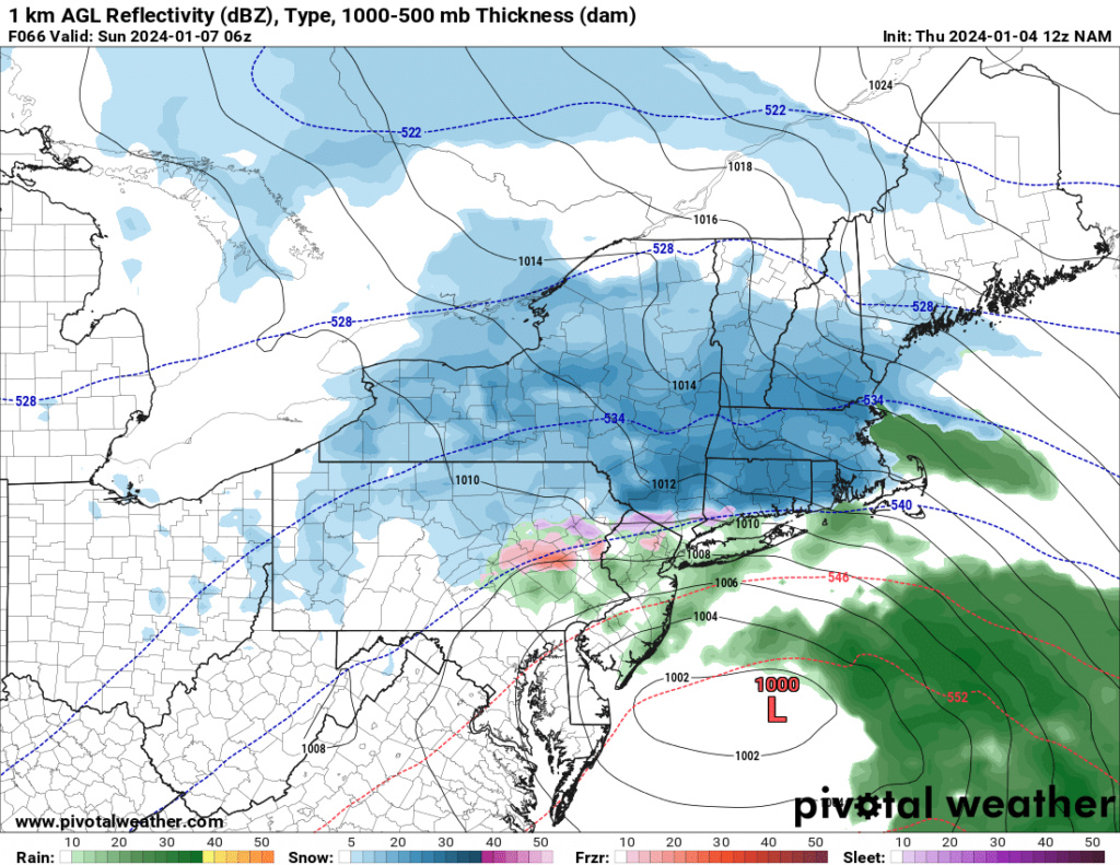
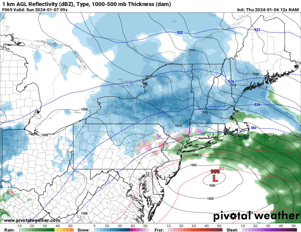
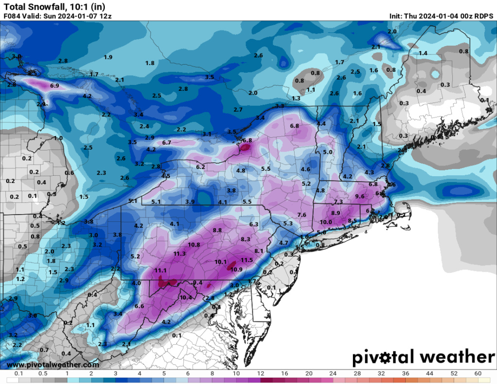
I know, I hate how razor sharp the cutoff is, literally 9.5 miles to my north it goes from 2-3 to 6+, amazing, i want to see at least a decent amount into the pink on TT to feel safe. Still thinking this may be a nowcast for NYC and my area even if models do show a change for the better, lots of things at play that change during storms as we have seen many times 2 years ago lolrb924119 wrote:jmanley32 wrote:Did not look like it to me on TT, but its not very hi-res or close up snow map.rb924119 wrote:Looks like NAM is ALL SNOW KNYC…..waiting on better maps to confirm.
Verbatim they are apparently on the line lol my bad, but Jimminy Crickets you’re right freakin’ thereeeeeeeee lol
Also love how it’s extending the precip shield further west even as the low continues to the east-northeast, which is what we should see in this scenario, as discussed earlier in the week.
jmanley32- Senior Enthusiast

- Posts : 20535
Join date : 2013-12-12
rb924119 likes this post
 Re: JAN 6th-7th Storm Thread I
amugs wrote:
On soundings it has a dry mid level wedge in various spots since the energy is not consolidated.
6Z EURO was colder and took a tick SE by about 25 miles - the wobbling and waffling continues!
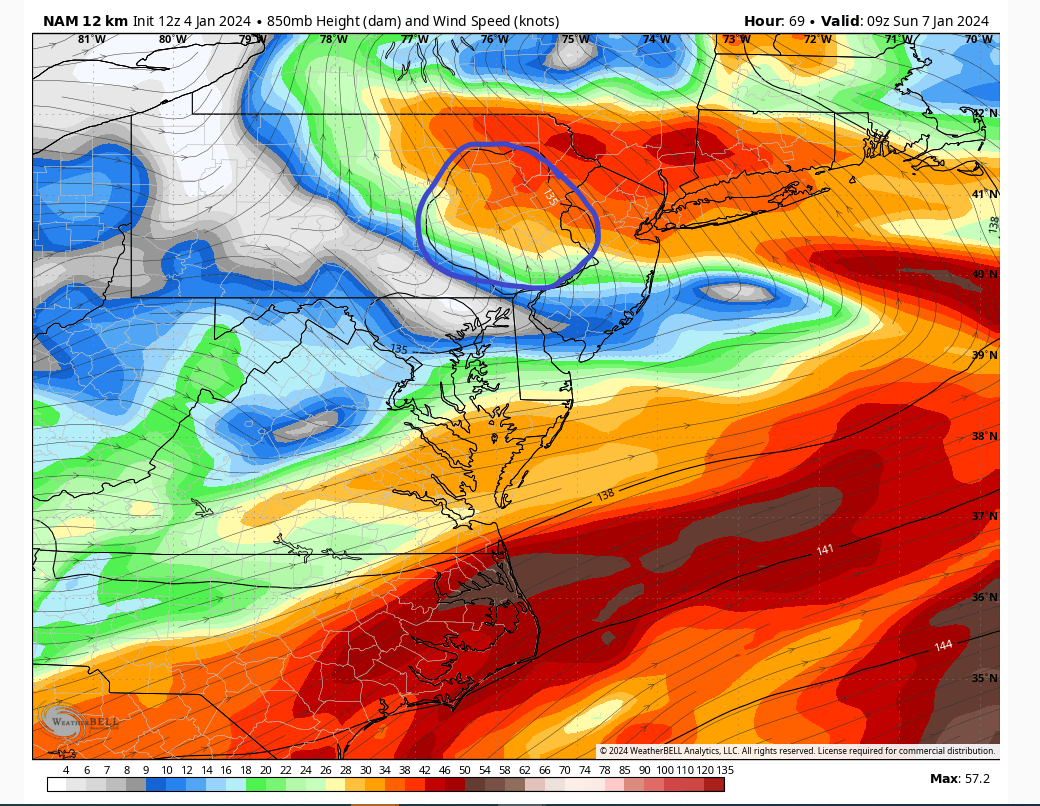
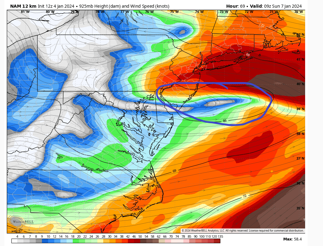
It’s because it’s basically closing the lower level circulation (850 hPa) off overhead. That’s why the precip goes from a burst of snow to snizzle, then back to snow once it passes by.
rb924119- Meteorologist

- Posts : 6928
Reputation : 194
Join date : 2013-02-06
Age : 32
Location : Greentown, Pa
 Re: JAN 6th-7th Storm Thread I
rb924119 wrote:amugs wrote:
On soundings it has a dry mid level wedge in various spots since the energy is not consolidated.
6Z EURO was colder and took a tick SE by about 25 miles - the wobbling and waffling continues!
It’s because it’s basically closing the lower level circulation (850 hPa) off overhead. That’s why the precip goes from a burst of snow to snizzle, then back to snow once it passes by.
So i guess the question is... do we still have room to get the lower level circulation to close off earlier?
_________________
-Alex Iannone-

aiannone- Senior Enthusiast - Mod

- Posts : 4815
Reputation : 92
Join date : 2013-01-07
Location : Saint James, LI (Northwest Suffolk Co.)
 Re: JAN 6th-7th Storm Thread I
aiannone wrote:rb924119 wrote:amugs wrote:
On soundings it has a dry mid level wedge in various spots since the energy is not consolidated.
6Z EURO was colder and took a tick SE by about 25 miles - the wobbling and waffling continues!
It’s because it’s basically closing the lower level circulation (850 hPa) off overhead. That’s why the precip goes from a burst of snow to snizzle, then back to snow once it passes by.
So i guess the question is... do we still have room to get the lower level circulation to close off earlier?
I think so, but even if not, a slight shift further to the east-southeast would do the trick too. Get them together, and NYC is cooking with gas.
rb924119- Meteorologist

- Posts : 6928
Reputation : 194
Join date : 2013-02-06
Age : 32
Location : Greentown, Pa
 Re: JAN 6th-7th Storm Thread I
[quote="rb924119"]
It’s because it’s basically closing the lower level circulation (850 hPa) off overhead. That’s why the precip goes from a burst of snow to snizzle, then back to snow once it passes by.[/
RB any idea when we would be getting the Recon sampling?
amugs wrote:
On soundings it has a dry mid level wedge in various spots since the energy is not consolidated.
6Z EURO was colder and took a tick SE by about 25 miles - the wobbling and waffling continues!
It’s because it’s basically closing the lower level circulation (850 hPa) off overhead. That’s why the precip goes from a burst of snow to snizzle, then back to snow once it passes by.[/
RB any idea when we would be getting the Recon sampling?
Artechmetals- Pro Enthusiast

- Posts : 571
Reputation : 3
Join date : 2014-01-01
Age : 57
Location : Wayne , NJ
heehaw453- Advanced Forecaster

- Posts : 3906
Reputation : 86
Join date : 2014-01-20
Location : Bedminster Township, PA Elevation 600' ASL
rb924119 likes this post
 Re: JAN 6th-7th Storm Thread I
OMG YES! I have never been able to use this now I can!rb924119 wrote:aiannone wrote:rb924119 wrote:amugs wrote:
On soundings it has a dry mid level wedge in various spots since the energy is not consolidated.
6Z EURO was colder and took a tick SE by about 25 miles - the wobbling and waffling continues!
It’s because it’s basically closing the lower level circulation (850 hPa) off overhead. That’s why the precip goes from a burst of snow to snizzle, then back to snow once it passes by.
So i guess the question is... do we still have room to get the lower level circulation to close off earlier?
I think so, but even if not, a slight shift further to the east-southeast would do the trick too. Get them together, and NYC is cooking with gas.
https://www.youtube.com/watch?v=FJRQo5aawho
Real public service anouncement from 1980's. I found it because a DJ I listen to utilizes it as a sample in his mix (DJ Shadow, if anyone knows him).

jmanley32- Senior Enthusiast

- Posts : 20535
Reputation : 108
Join date : 2013-12-12
Age : 43
Location : Yonkers, NY
rb924119 likes this post
 Re: JAN 6th-7th Storm Thread I
jmanley32 wrote:OMG YES! I have never been able to use this now I can!rb924119 wrote:aiannone wrote:rb924119 wrote:amugs wrote:
On soundings it has a dry mid level wedge in various spots since the energy is not consolidated.
6Z EURO was colder and took a tick SE by about 25 miles - the wobbling and waffling continues!
It’s because it’s basically closing the lower level circulation (850 hPa) off overhead. That’s why the precip goes from a burst of snow to snizzle, then back to snow once it passes by.
So i guess the question is... do we still have room to get the lower level circulation to close off earlier?
I think so, but even if not, a slight shift further to the east-southeast would do the trick too. Get them together, and NYC is cooking with gas.
https://www.youtube.com/watch?v=FJRQo5aawho
Real public service anouncement from 1980's. I found it because a DJ I listen to utilizes it as a sample in his mix (DJ Shadow, if anyone knows him).
OH MY……

rb924119- Meteorologist

- Posts : 6928
Reputation : 194
Join date : 2013-02-06
Age : 32
Location : Greentown, Pa
 Re: JAN 6th-7th Storm Thread I
Artechmetals wrote:rb924119 wrote:amugs wrote:
On soundings it has a dry mid level wedge in various spots since the energy is not consolidated.
6Z EURO was colder and took a tick SE by about 25 miles - the wobbling and waffling continues!
It’s because it’s basically closing the lower level circulation (850 hPa) off overhead. That’s why the precip goes from a burst of snow to snizzle, then back to snow once it passes by.[/
RB any idea when we would be getting the Recon sampling?
I think mugsy said they’ll be going out for tonight’s 00z runs, and then again tomorrow…?
rb924119- Meteorologist

- Posts : 6928
Reputation : 194
Join date : 2013-02-06
Age : 32
Location : Greentown, Pa
amugs likes this post
heehaw453- Advanced Forecaster

- Posts : 3906
Reputation : 86
Join date : 2014-01-20
Location : Bedminster Township, PA Elevation 600' ASL
rb924119 likes this post
 Re: JAN 6th-7th Storm Thread I
Agree 100%.
rb924119- Meteorologist

- Posts : 6928
Reputation : 194
Join date : 2013-02-06
Age : 32
Location : Greentown, Pa
 Re: JAN 6th-7th Storm Thread I
I know it is about the worst rap attempt ever, DJ Shadow loves to mix in goofy stuff and he added a sick beat to it.rb924119 wrote:jmanley32 wrote:OMG YES! I have never been able to use this now I can!rb924119 wrote:aiannone wrote:rb924119 wrote:amugs wrote:
On soundings it has a dry mid level wedge in various spots since the energy is not consolidated.
6Z EURO was colder and took a tick SE by about 25 miles - the wobbling and waffling continues!
It’s because it’s basically closing the lower level circulation (850 hPa) off overhead. That’s why the precip goes from a burst of snow to snizzle, then back to snow once it passes by.
So i guess the question is... do we still have room to get the lower level circulation to close off earlier?
I think so, but even if not, a slight shift further to the east-southeast would do the trick too. Get them together, and NYC is cooking with gas.
https://www.youtube.com/watch?v=FJRQo5aawho
Real public service anouncement from 1980's. I found it because a DJ I listen to utilizes it as a sample in his mix (DJ Shadow, if anyone knows him).
OH MY……

jmanley32- Senior Enthusiast

- Posts : 20535
Reputation : 108
Join date : 2013-12-12
Age : 43
Location : Yonkers, NY
 Re: JAN 6th-7th Storm Thread I
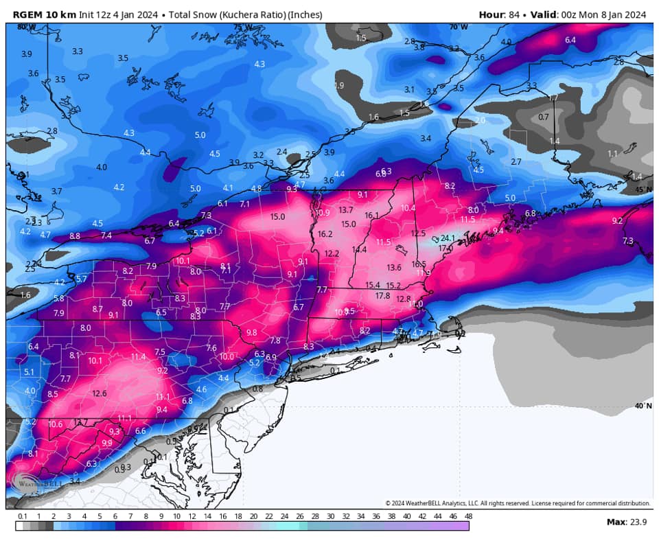
RGEM looks worse to me, but waiting to confirm.
rb924119- Meteorologist

- Posts : 6928
Reputation : 194
Join date : 2013-02-06
Age : 32
Location : Greentown, Pa
 Re: JAN 6th-7th Storm Thread I
rb924119 wrote:RGEM looks worse to me, but waiting to confirm.
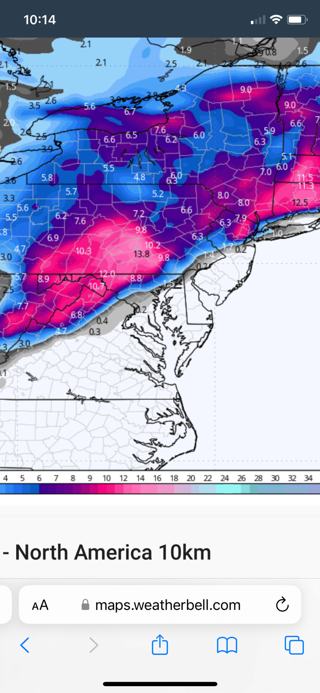
Actually, maybe not as bad as I thought. It looks like it consolidates/slips east sooner than previous runs, which gets the area into more wrap-around snow on the back side, but, it’s also warmer with the approach of the low-level centers overhead, similarly to the NAM. So a give and take there.
rb924119- Meteorologist

- Posts : 6928
Reputation : 194
Join date : 2013-02-06
Age : 32
Location : Greentown, Pa
 Re: JAN 6th-7th Storm Thread I
rb924119 wrote:rb924119 wrote:RGEM looks worse to me, but waiting to confirm.
Actually, maybe not as bad as I thought. It looks like it consolidates/slips east sooner than previous runs, which gets the area into more wrap-around snow on the back side, but, it’s also warmer with the approach of the low-level centers overhead, similarly to the NAM. So a give and take there.
rb924119- Meteorologist

- Posts : 6928
Reputation : 194
Join date : 2013-02-06
Age : 32
Location : Greentown, Pa
 Re: JAN 6th-7th Storm Thread I
Definitely more snow that run further southeast.
rb924119- Meteorologist

- Posts : 6928
Reputation : 194
Join date : 2013-02-06
Age : 32
Location : Greentown, Pa
 Re: JAN 6th-7th Storm Thread I
So that means that we should see a similar change to the regular GEM.
rb924119- Meteorologist

- Posts : 6928
Reputation : 194
Join date : 2013-02-06
Age : 32
Location : Greentown, Pa
 Re: JAN 6th-7th Storm Thread I
_________________
-Alex Iannone-

aiannone- Senior Enthusiast - Mod

- Posts : 4815
Reputation : 92
Join date : 2013-01-07
Location : Saint James, LI (Northwest Suffolk Co.)
 Re: JAN 6th-7th Storm Thread I
Still screws southern WC but NYC gets into the 6 inch as dioes across the river from me lol, this storm has a vendetta against my area, all joking aside it is better and IMO that area over eastern NJ should be expanded over southern WC, its just like 1 mile away. Weird the snow map alex posted versus you ray do not match.rb924119 wrote:Definitely more snow that run further southeast.

jmanley32- Senior Enthusiast

- Posts : 20535
Reputation : 108
Join date : 2013-12-12
Age : 43
Location : Yonkers, NY
rb924119- Meteorologist

- Posts : 6928
Reputation : 194
Join date : 2013-02-06
Age : 32
Location : Greentown, Pa
 Re: JAN 6th-7th Storm Thread I
rb924119 wrote:So that means that we should see a similar change to the regular GEM.
It's all about getting this thing to consolidate just a little faster. It's clear it's going to do it eventually. But eventually is the wild card.
heehaw453- Advanced Forecaster

- Posts : 3906
Reputation : 86
Join date : 2014-01-20
Location : Bedminster Township, PA Elevation 600' ASL
rb924119 likes this post

aiannone- Senior Enthusiast - Mod

- Posts : 4815
Reputation : 92
Join date : 2013-01-07
Location : Saint James, LI (Northwest Suffolk Co.)
rb924119 likes this post
 Re: JAN 6th-7th Storm Thread I
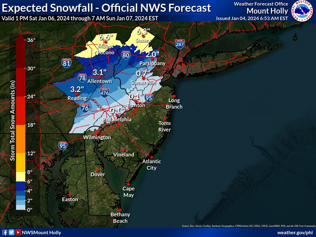
NWS going with...



_________________
Mugs
AKA:King: Snow Weenie
Self Proclaimed
WINTER 2014-15 : 55.12" +.02 for 6 coatings (avg. 35")
WINTER 2015-16 Total - 29.8" (Avg 35")
WINTER 2016-17 : 39.5" so far

amugs- Advanced Forecaster - Mod

- Posts : 15095
Reputation : 213
Join date : 2013-01-07
Age : 54
Location : Hillsdale,NJ
 Re: JAN 6th-7th Storm Thread I
amugs wrote:NWS going with...
They just tweeted their first official snowmap for the storm wont be released until this afternoon
_________________
-Alex Iannone-

aiannone- Senior Enthusiast - Mod

- Posts : 4815
Reputation : 92
Join date : 2013-01-07
Location : Saint James, LI (Northwest Suffolk Co.)

aiannone- Senior Enthusiast - Mod

- Posts : 4815
Reputation : 92
Join date : 2013-01-07
Location : Saint James, LI (Northwest Suffolk Co.)
rb924119 likes this post
rb924119- Meteorologist

- Posts : 6928
Reputation : 194
Join date : 2013-02-06
Age : 32
Location : Greentown, Pa
Page 5 of 16 •  1, 2, 3, 4, 5, 6 ... 10 ... 16
Page 5 of 16
Permissions in this forum:
You cannot reply to topics in this forum|
|
|

 Home
Home
