Long Range Thread 28.0
+33
weatherwatchermom
essexcountypete
skinsfan1177
aiannone
larryrock72
Coachgriff
DAYBLAZER
nutleyblizzard
hyde345
docstox12
CPcantmeasuresnow
frank 638
Koroptim
HectorO
billg315
dkodgis
MattyICE
toople
sroc4
rb924119
Grselig
crippo84
phil155
Frank_Wx
jmanley32
NJBear
tomsriversnowstorm
Carvin
heehaw453
SENJsnowman
Irish
amugs
richb521
37 posters
Page 10 of 18
Page 10 of 18 •  1 ... 6 ... 9, 10, 11 ... 14 ... 18
 Re: Long Range Thread 28.0
Still pretty big differences in the exact timing of the main precip. Euro has it over pretty much by early afternoon and GFS is just getting going by early afternoon. Both images valid 1pm Tuesday.
IMO the GFS although has been a bit back and forth has trended towards less n/s interactions which in the end will lead to a less amplified soln and much lower totals.


IMO the GFS although has been a bit back and forth has trended towards less n/s interactions which in the end will lead to a less amplified soln and much lower totals.


sroc4- Admin

- Posts : 8354
Join date : 2013-01-07
heehaw453 and MattyICE like this post
 Re: Long Range Thread 28.0
12z GFS another tick north. 12z GFS and 0z Euro have similar look for snowfall. Have to see where the 12z Euro goes, but atm they’re pretty close to being on the same page. Three days out, take it for what it’s worth.
billg315- Advanced Forecaster - Mod

- Posts : 4483
Join date : 2015-01-24
 Re: Long Range Thread 28.0
GFS still a little more robust with snow amounts and coverage, but the general axis of the accumulating snow is similar to the 0z Euro. As Scott points out, there are still timing differences. GFS is an early Tue. AM arrival and a departure around midnight that night. 0z Euro was Monday evening arrival with Tuesday afternoon departure.

billg315- Advanced Forecaster - Mod

- Posts : 4483
Reputation : 185
Join date : 2015-01-24
Age : 50
Location : Flemington, NJ

billg315- Advanced Forecaster - Mod

- Posts : 4483
Reputation : 185
Join date : 2015-01-24
Age : 50
Location : Flemington, NJ
CPcantmeasuresnow likes this post
 Re: Long Range Thread 28.0
12Z GFS OP is more tucked. There is potent energy with the s/s as it's been fed a bit by the n/s as it matures over TX. However you can see the oval gap and the bar above it. If this storm is going to produce BIG amounts IMO there needs some capture by the n/s which would pull the storm back a bit and slow it down. That should occur before the ULL hits the coast. What the GFS is doing is intensifying the storm with one stream because it hits resistance and all the parts slam into each other. I guess that's possible but if that plays out the n/s is really a kicker.
The other thing we need to be mindful of how far north the southern storm gets north before it's forced eastward. I think enough confluence is there to keep things from getting too far north but it's a consideration IMO.
The 12Z GEFS are bullish from Mason Dixon line northward but keep in mind 10th percentile still have next to nothing with this. Unlikely but some solutions show that.
The 12Z Canadian is coming more inline with colder/stronger solution. Same with 12Z Ukie.
Overall my confidence hasn't increased too much with this for now.

heehaw453- Advanced Forecaster

- Posts : 3906
Reputation : 86
Join date : 2014-01-20
Location : Bedminster Township, PA Elevation 600' ASL
 Re: Long Range Thread 28.0
Generally when I see a TPV (blue area) in Quebec it usually means the storm doesn't get too far north and the southerly flow is limited in time. You can see the interaction there with the TPV pushing down. It will try to be pulled up by the n/s and that's when the southerly flow would be a concern, but it quickly gets compressed.
heehaw453- Advanced Forecaster

- Posts : 3906
Reputation : 86
Join date : 2014-01-20
Location : Bedminster Township, PA Elevation 600' ASL
 Re: Long Range Thread 28.0
12Z Euro is pretty tucked. Strong storm. Good for the I84 folks. Personally, not much confidence in much expect a strong storm does seem more likely than not. Is going to tuck too much for coastal plain and I-95. It might.
heehaw453- Advanced Forecaster

- Posts : 3906
Reputation : 86
Join date : 2014-01-20
Location : Bedminster Township, PA Elevation 600' ASL

billg315- Advanced Forecaster - Mod

- Posts : 4483
Reputation : 185
Join date : 2015-01-24
Age : 50
Location : Flemington, NJ
CPcantmeasuresnow likes this post
 Re: Long Range Thread 28.0
So, I'm reading that we really need things to work out within the next 2 weeks in regard to winter weather, as the long range expected cold may not be materializing as hoped. After the possibility of a Presidents' Day storm, we may be done and truly looking at an early spring.

Irish- Pro Enthusiast

- Posts : 788
Reputation : 19
Join date : 2019-01-16
Age : 45
Location : Old Bridge, NJ
phil155 and Coachgriff like this post
 Re: Long Range Thread 28.0
Irish wrote:So, I'm reading that we really need things to work out within the next 2 weeks in regard to winter weather, as the long range expected cold may not be materializing as hoped. After the possibility of a Presidents' Day storm, we may be done and truly looking at an early spring.
I thought we were entering a period of sustained cold from essentially later this coming week through mid march, to me that does not mean every single day but the way it has been advertised is that it is the vast and overwhelming majority of days..... and now that is not the case? What happened?
phil155- Pro Enthusiast

- Posts : 483
Reputation : 4
Join date : 2019-12-16
 Re: Long Range Thread 28.0
Bernie thinks the models will continue to shift northwards, with no accumulating snow south of Rt 80. Nada for Phila, NYC, all of NJ but for the most northern areas. That would not be out of character for this winter so far.
https://www.youtube.com/watch?v=iog7GNXbvPI
https://www.youtube.com/watch?v=iog7GNXbvPI

essexcountypete- Pro Enthusiast

- Posts : 783
Reputation : 12
Join date : 2013-12-09
Location : Bloomfield, NJ
 Re: Long Range Thread 28.0
essexcountypete wrote:Bernie thinks the models will continue to shift northwards, with no accumulating snow south of Rt 80. Nada for Phila, NYC, all of NJ but for the most northern areas. That would not be out of character for this winter so far.
https://www.youtube.com/watch?v=iog7GNXbvPI
That would not be out of character for this winter at all
_________________
"In weather and in life, there's no winning and losing; there's only winning and learning."
WINTER 2012/2013 TOTALS 43.65"WINTER 2017/2018 TOTALS 62.85" WINTER 2022/2023 TOTALS 4.9"
WINTER 2013/2014 TOTALS 64.85"WINTER 2018/2019 TOTALS 14.25" WINTER 2023/2024 TOTALS 13.1"
WINTER 2014/2015 TOTALS 71.20"WINTER 2019/2020 TOTALS 6.35"
WINTER 2015/2016 TOTALS 35.00"WINTER 2020/2021 TOTALS 37.75"
WINTER 2016/2017 TOTALS 42.25"WINTER 2021/2022 TOTALS 31.65"

sroc4- Admin

- Posts : 8354
Reputation : 302
Join date : 2013-01-07
Location : Wading River, LI
 Re: Long Range Thread 28.0
phil155 wrote:Irish wrote:So, I'm reading that we really need things to work out within the next 2 weeks in regard to winter weather, as the long range expected cold may not be materializing as hoped. After the possibility of a Presidents' Day storm, we may be done and truly looking at an early spring.
I thought we were entering a period of sustained cold from essentially later this coming week through mid march, to me that does not mean every single day but the way it has been advertised is that it is the vast and overwhelming majority of days..... and now that is not the case? What happened?
No one that I saw said colder temps wouldn't materialize. Not sure where Irish got that from.
_________________
"In weather and in life, there's no winning and losing; there's only winning and learning."
WINTER 2012/2013 TOTALS 43.65"WINTER 2017/2018 TOTALS 62.85" WINTER 2022/2023 TOTALS 4.9"
WINTER 2013/2014 TOTALS 64.85"WINTER 2018/2019 TOTALS 14.25" WINTER 2023/2024 TOTALS 13.1"
WINTER 2014/2015 TOTALS 71.20"WINTER 2019/2020 TOTALS 6.35"
WINTER 2015/2016 TOTALS 35.00"WINTER 2020/2021 TOTALS 37.75"
WINTER 2016/2017 TOTALS 42.25"WINTER 2021/2022 TOTALS 31.65"

sroc4- Admin

- Posts : 8354
Reputation : 302
Join date : 2013-01-07
Location : Wading River, LI
 Re: Long Range Thread 28.0
I will say that just a few days after TWC app finally showed high temps staying in the 30s for days 6-14, now that’s only case for like 3 of the days and all the rest are back in the 40s. Low temps two days ago showed all 20s and now show an even mix of 20s and 30s. So, just based on that, I was also wondering if the sustained cold outlook had taken a step back.
SENJsnowman- Senior Enthusiast

- Posts : 1189
Reputation : 61
Join date : 2017-01-06
Age : 51
Location : Bayville, NJ
Coachgriff likes this post
 Re: Long Range Thread 28.0
sroc4 wrote:essexcountypete wrote:Bernie thinks the models will continue to shift northwards, with no accumulating snow south of Rt 80. Nada for Phila, NYC, all of NJ but for the most northern areas. That would not be out of character for this winter so far.
https://www.youtube.com/watch?v=iog7GNXbvPI
That would not be out of character for this winter at all
Great Bernie video.That would get me 3 inches out of this, better than the rain/snow NWS had me for a few days ago.Of course, a further North shift would wipe that out.

docstox12- Wx Statistician Guru

- Posts : 8530
Reputation : 222
Join date : 2013-01-07
Age : 73
Location : Monroe NY
 Re: Long Range Thread 28.0
SENJsnowman wrote:I will say that just a few days after TWC app finally showed high temps staying in the 30s for days 6-14, now that’s only case for like 3 of the days and all the rest are back in the 40s. Low temps two days ago showed all 20s and now show an even mix of 20s and 30s. So, just based on that, I was also wondering if the sustained cold outlook had taken a step back.
Those numbers tend to bounce around so I wouldn't read too much into that. Remember also that by mid-to-late February the normal High Temp in South Jersey is 44 degrees. So any High temps 43 or less is below normal for that period. Here's an article from this afternoon referring to the colder weather ahead:
https://www.nj.com/weather/2024/02/polar-vortex-disruption-to-unleash-cold-air-into-us-in-big-winter-resurgence.html

billg315- Advanced Forecaster - Mod

- Posts : 4483
Reputation : 185
Join date : 2015-01-24
Age : 50
Location : Flemington, NJ
SENJsnowman likes this post
 Re: Long Range Thread 28.0
docstox12 wrote:sroc4 wrote:essexcountypete wrote:Bernie thinks the models will continue to shift northwards, with no accumulating snow south of Rt 80. Nada for Phila, NYC, all of NJ but for the most northern areas. That would not be out of character for this winter so far.
https://www.youtube.com/watch?v=iog7GNXbvPI
That would not be out of character for this winter at all
Great Bernie video.That would get me 3 inches out of this, better than the rain/snow NWS had me for a few days ago.Of course, a further North shift would wipe that out.
Given the way the last round of snow events went for my area, I will not at all be surprised if this ends up being a 1-3" event IMBY. I'm hoping for more . . . but definitely not counting on it. If I get NO snow out of this event, I will be disappointed.

billg315- Advanced Forecaster - Mod

- Posts : 4483
Reputation : 185
Join date : 2015-01-24
Age : 50
Location : Flemington, NJ
 Re: Long Range Thread 28.0
18z NAM just out of range. But the end of the run at midnight Monday night has snow just starting to spread into northern New Jersey and rain into southern New Jersey. Surface temps at that time are a few degrees colder than the GFS in the northern half of NJ. The 850 0* line is about 25-30 miles further south. This, of course, is like trying to read tea leaves. But the NAM seems to be coming in a bit colder. Cold air press to the north is a little further south as well. We'll see where it is when it is fully in range with tomorrow morning's runs.

billg315- Advanced Forecaster - Mod

- Posts : 4483
Reputation : 185
Join date : 2015-01-24
Age : 50
Location : Flemington, NJ
 Re: Long Range Thread 28.0
billg315 wrote:18z NAM just out of range. But the end of the run at midnight Monday night has snow just starting to spread into northern New Jersey and rain into southern New Jersey. Surface temps at that time are a few degrees colder than the GFS in the northern half of NJ. The 850 0* line is about 25-30 miles further south. This, of course, is like trying to read tea leaves. But the NAM seems to be coming in a bit colder. Cold air press to the north is a little further south as well. We'll see where it is when it is fully in range with tomorrow morning's runs.
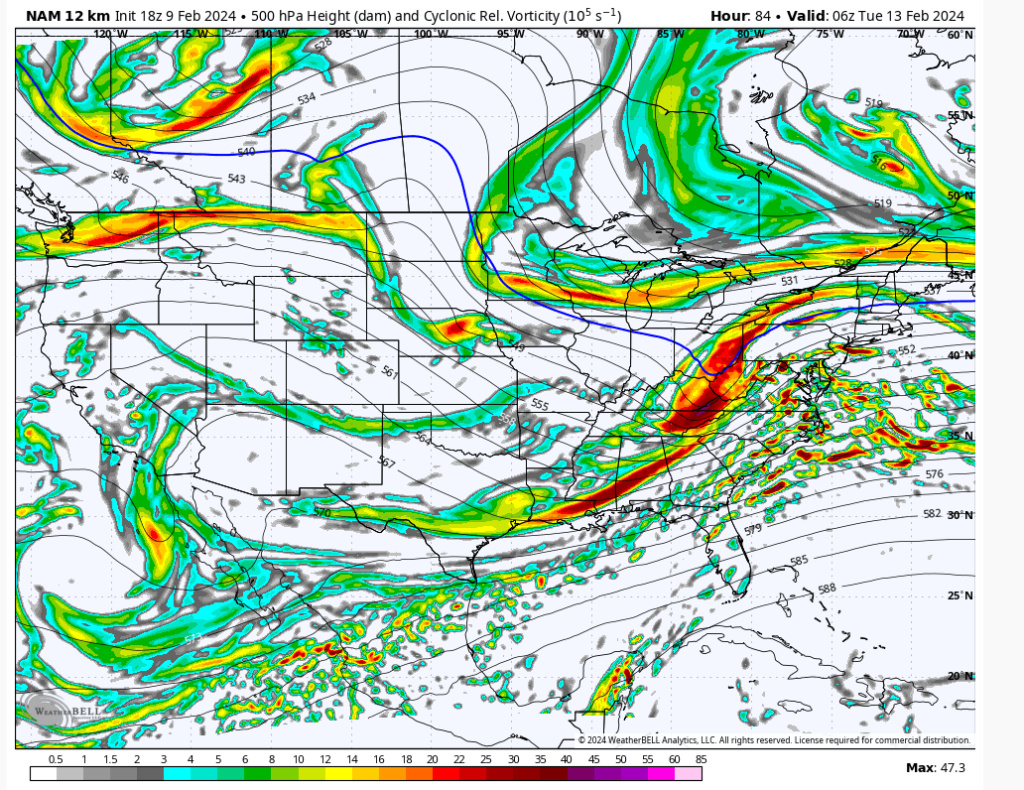
The NAM is less amped than Euro/GFS at its 84 hour. Take it FWIW, but if ULL gets too aggressive too early that will push against the resistance just enough to taint the mid-levels. This is not a matter IMO of enough confluence to the north. It's more a matter of an aggressive southern storm. Latitude is critical. Clear difference in the strength of the ULL at same time is the difference of 50 miles in the snow axis.


heehaw453- Advanced Forecaster

- Posts : 3906
Reputation : 86
Join date : 2014-01-20
Location : Bedminster Township, PA Elevation 600' ASL
 Re: Long Range Thread 28.0
The other thing too to point out. A bad track will mix. I don't care what the antecedent air mass is. What a good high pressure does (which we don't have here) is create a bit more resistance. But a too amped up low pressure will cut it through it like butter at the mid-levels. It always track first then everything else IMO. No difference here.
heehaw453- Advanced Forecaster

- Posts : 3906
Reputation : 86
Join date : 2014-01-20
Location : Bedminster Township, PA Elevation 600' ASL
 Re: Long Range Thread 28.0
https://www.dailymail.co.uk/news/article-13066329/northeast-massive-winter-storm-snowmaggedon.html
Just sat down and poking around and saw this article so I rushed to our site...what am I missing here..

Just sat down and poking around and saw this article so I rushed to our site...what am I missing here..

weatherwatchermom- Senior Enthusiast

- Posts : 3793
Reputation : 78
Join date : 2014-11-25
Location : Hazlet Township, NJ
 Re: Long Range Thread 28.0
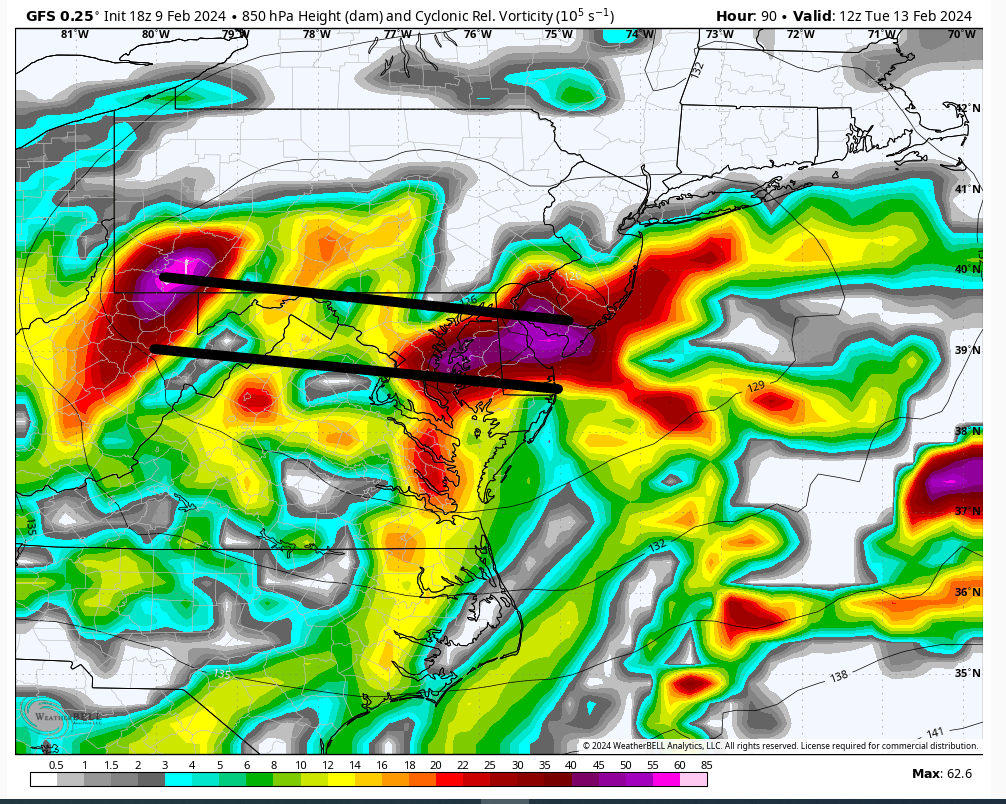
18Z GFS If this mid-level energy starts that transfer process about 75 miles south it'll have big implications for the I95. Ratios and snow amts will be much better if that were to happen. At 90 hrs there's pretty big wiggle room either way. But this solution it absolutely hits a brick wall partly due to the n/s kicker behind it. That's why it moves so quickly ENE. There is going to be surprises with this system due to that n/s IMO.


heehaw453- Advanced Forecaster

- Posts : 3906
Reputation : 86
Join date : 2014-01-20
Location : Bedminster Township, PA Elevation 600' ASL
 Re: Long Range Thread 28.0
weatherwatchermom wrote:https://www.dailymail.co.uk/news/article-13066329/northeast-massive-winter-storm-snowmaggedon.html
Just sat down and poking around and saw this article so I rushed to our site...what am I missing here..
Northeast braces for massive winter storms set to hit next week from Pennsylvania to Massachusetts - with experts saying they could mimic 'Snowmaggedon' of 2010 and won't rule out a bombogenesis
Interesting article Mom thanks. The above headline is interesting to me. That year Philly had 53" of snow in February alone. I don't know if the author of the article is familiar with the scale of snow that occurred. If I get 10" this month with 1 week of snow depth I'll call it a win.
heehaw453- Advanced Forecaster

- Posts : 3906
Reputation : 86
Join date : 2014-01-20
Location : Bedminster Township, PA Elevation 600' ASL
 Re: Long Range Thread 28.0
51 and Sunny on Monday in Central NJ….not sure I buy Snowmageddon

Coachgriff- Posts : 57
Reputation : 0
Join date : 2022-01-29
 Re: Long Range Thread 28.0
Lol. Wow. Didn't bother to read the article. Any use of the word "snowmageddon" (which probably shouldn't be used in any storm/pattern as it's rather silly) with this storm or this pattern is laughable.
As I said earlier today, I'll be happy to get a few inches out of this storm. Thrilled if more, not shocked if less. Beyond that, while there is some cold air coming, I don't see any signs (yet) of any blockbuster storms in the next week or so.
As I said earlier today, I'll be happy to get a few inches out of this storm. Thrilled if more, not shocked if less. Beyond that, while there is some cold air coming, I don't see any signs (yet) of any blockbuster storms in the next week or so.

billg315- Advanced Forecaster - Mod

- Posts : 4483
Reputation : 185
Join date : 2015-01-24
Age : 50
Location : Flemington, NJ
kalleg and weatherwatchermom like this post
 Re: Long Range Thread 28.0
18z GFS didn't change much from earlier. Maybe a tick south again if anything. The Euro and GFS have pretty much settled in for the last 24 hours with the Euro just a bit more north and a little less snowy than the GFS. At this point I'm anxious to see how the NAM weighs in tomorrow and Sunday.

billg315- Advanced Forecaster - Mod

- Posts : 4483
Reputation : 185
Join date : 2015-01-24
Age : 50
Location : Flemington, NJ
 Re: Long Range Thread 28.0
heehaw453 wrote:The other thing too to point out. A bad track will mix. I don't care what the antecedent air mass is. What a good high pressure does (which we don't have here) is create a bit more resistance. But a too amped up low pressure will cut it through it like butter at the mid-levels. It always track first then everything else IMO. No difference here.
Agree with this 100%. I've been meaning to comment on this earlier today in a slightly different context but closely related. I think it's important for folks to understand that most of these close-call winter storms are heavily track-driven rather than solely temperature regime driven. So you can't solely look at the temperatures the day before, or the forecast temperature in a model that shows rain at that moment and say it will be "too warm for snow," etc etc. because the right track and right dynamics very often create their own cold air in most of these storms. If you are seeing warm forecast temps in your forecast app, it's usually because the model is at that time anticipating a warm-favoring storm TRACK/DYNAMICS. You will notice the forecast temp on your app will change to colder temps if the models start to show the storm track/dynamics changing.
For example: If a storm cuts to our west, or directly over us, more often than not it's going to be rain (or snow to mix to rain) even if cold air is in place. If it's to our south and east and a cold air source is available, more often than not someone is getting some snow even if its warm the day before. Usually, IMO, especially in the heart of winter, the storm determines the temperature more than the temperature determining the storm. This is how in March you can get a 55 degree day followed by a blizzard the next day.
Now there are exceptions to every rule, and there are absolutely times where a warm antecedent air mass will make it harder to get snow (especially in over-running events, or with weaker storm systems, or borderline storm tracks) so I don't discount the value of having cold air in place. Trust me, I'd rather have cold air in place AND a good track.
But more often than not I'd rather have a good track with marginal temperatures at the start than a bad track with colder temps at the start.

billg315- Advanced Forecaster - Mod

- Posts : 4483
Reputation : 185
Join date : 2015-01-24
Age : 50
Location : Flemington, NJ
docstox12, kalleg, heehaw453, SENJsnowman and JT33 like this post
Page 10 of 18 •  1 ... 6 ... 9, 10, 11 ... 14 ... 18
Page 10 of 18
Permissions in this forum:
You cannot reply to topics in this forum|
|
|

 Home
Home
