February 12th-13th 2024 Pre-Valentines Day Storm Potential
+31
richb521
brownie
Carvin
silentwreck
dkodgis
NJBear
essexcountypete
amugs
tomsriversnowstorm
aiannone
SENJsnowman
jmanley32
nutleyblizzard
dsix85
docstox12
toople
Irish
Dunnzoo
Koroptim
phil155
Frank_Wx
MattyICE
billg315
frank 638
hyde345
SNOW MAN
Artechmetals
CPcantmeasuresnow
heehaw453
JT33
sroc4
35 posters
Page 1 of 13
Page 1 of 13 • 1, 2, 3 ... 11, 12, 13 
 February 12th-13th 2024 Pre-Valentines Day Storm Potential
sroc4 wrote:
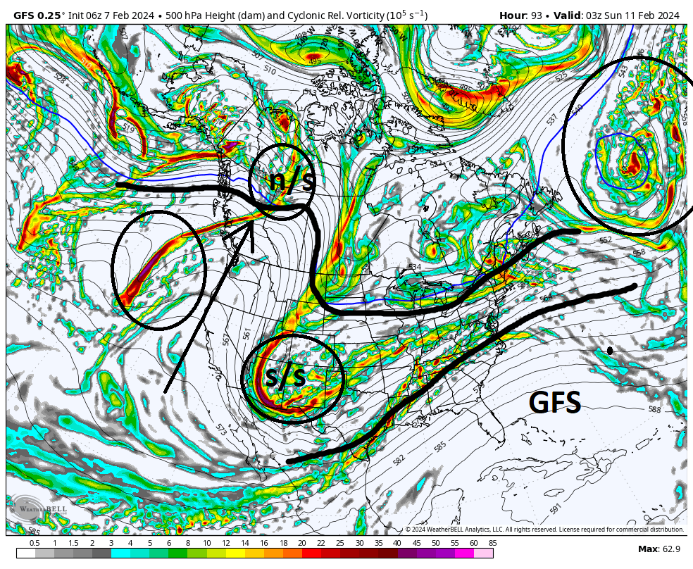
Here are most of the major players. As heehaw stated there are big picture players out over the pacific that justify us even talking about this as a potential. The SOI crash is legit, strong neg for now 10days. THIS is a major signal for a shake up to the atmosphere is underway, and cold is coming for the eastern third of the CONUS. The MJO is also on its way, if not already when you look at the OLR maps actually, into phase 8 which 100% supports a colder soln in the east. The MJO and the SOI are intimately linked, and adds another feather in the cap that supports a winter storm for the 12-14th time frame, as well as the potential for a more sustained colder pattern. BUT The question is still what about IMBY for the 12th-14th??
n/s = northern stream,
s/s = southern stream
First the Northern Atlantic. This area of energy is the 50/50-ISH low that will slow things down to allow these two pieces to interact. But the strength and positioning of the 50/50-ish low is the first extremely important factor in determining the when and how the n/s and s/s stream interact.
Second the ridge along the west coast that I outlined and show the ridge axis with the black arrow. All three models show it going up as we approach the time of the maps I posted. This is what allows the n/s energy to dig into the conus, and POTENTIALLY open the gates to the cold air source and add energy IF they interact at the right times. It is critical that the s/s energy gets out ahead of the n/s, but not too much. This allows the back side entry and tilts our heights up the coast. However, if the s/s is in line with or slight behind the n/s energy or if the n/s is not allowed to dig enough then it will act as a steering mechanism that brings the system OTS and minimal cold air involvement in which case you get a system that either slips off to to our south or we see the N edge of the precip shield but it isnt cold enough to make a huge potential, esp for the coastal plain.
Now what could lead to less n/s digging and or throw off the timing of the n/s will be the small area of vorticity I circled just off the west coast out over the Pac. This piece on all three models is there with subtle yet import differences in its timing, positioning and strength. On all models this piece of energy seems to be undercutting the WC ridge to a degree as it comes ashore and begins to knock down the ridge to varying degrees. This LIKELY WILL play a factor, for better or worse. The positioning and strength of the 50/50-ish low; however, is a mechanism, that could negate some of these effects.
Again the full details of ALL the key points I highlighted above will be important.
I would like everyone to quickly re-read some key points above from the write from Wed morn because we are going to see where we now stand.
Ok now that we are refreshed lets look at where we stand. Before we do I would like to point out that we have said in prev discussion pretty much all the players will be on the field come Sat. Meaning there is still time for things to evolve ie: some of the finer details of the R/S line and totals etc. For better or worse. Expect it.
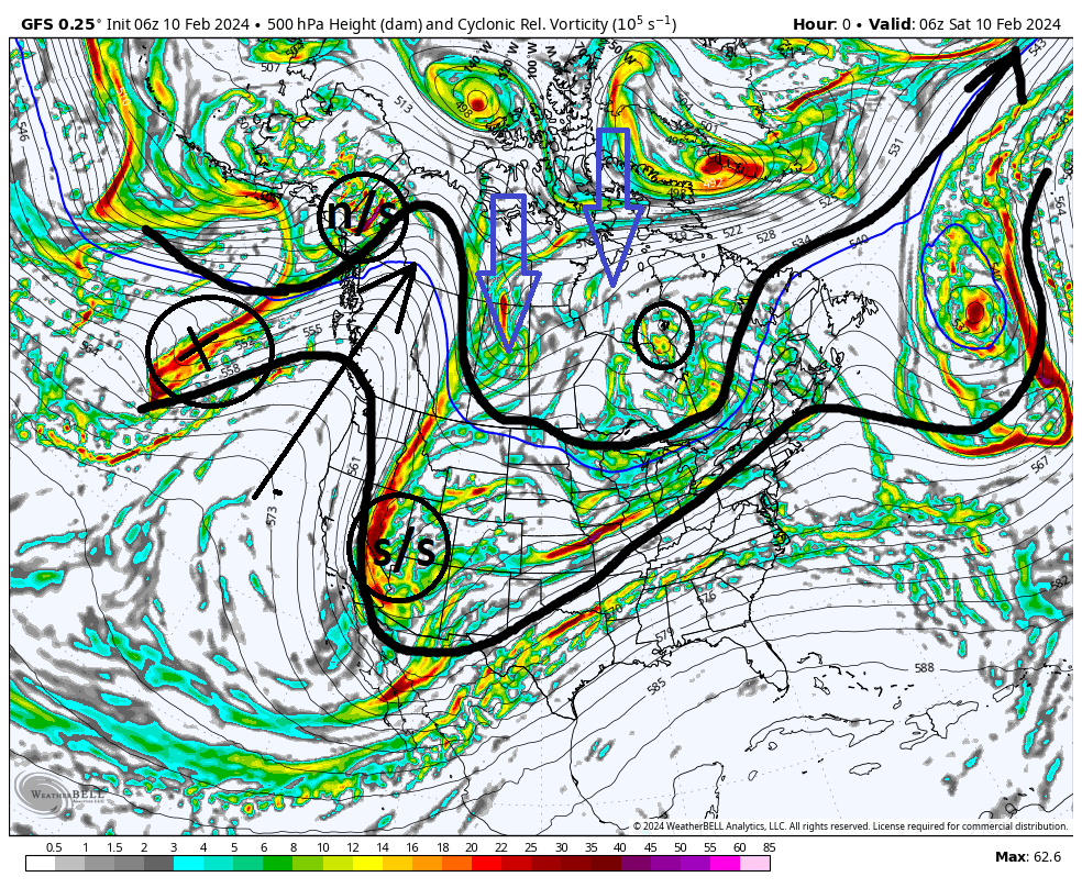
Ill use the 06z GFS for illustration. Here is the current position of the major players as of 06z GFS initialization. Notice the nice stout +PNA ridge along the WC. This has allowed a cold polar/arctic air mass to gather over much of Canada. Notice the area marked X out over the Pac. This is the "fly in the ointment" highlighted above, and WILL knock down the +PNA ridge over the next 24-48hrs. The n/s energy is just coming onto land, and the s/s energy is gathering in the SW CONUS.
Fast forward to approx 7pm Sunday eve.(see below) The n/s energy has come up and over our +PNA ridge and has begun to dig, but the area marked X has clearly undercut the PNA ridge and knocked it down to what I will refer to a mere "mogul" for those skiers out there. Also notice the area I point out with the arrows over the northern Gulf of Alaska (GOA). The s/s energy has begun to come out of the SW and into the N Texas region. Its potent as indicate by the deep red and purple colors. A key feature that is starting to come into focus on ALL three major models is the idea that the s/s energy aligns itself just out ahead of the n/s energy (see the thin black line I have connecting the two). The importance of this point cant be understated as we get closer. The cold air mass in Canada persists. (Keep in mind deep in the season a cold dense air mass does not move easily) As outlined out ahead of the s/s energy you can begin to see the channel for which the direction it will take coming out of Texas. The area in between the GL and the NE is our area of "confluence"...aka the area where the Northern Jet and southern Jet come together.
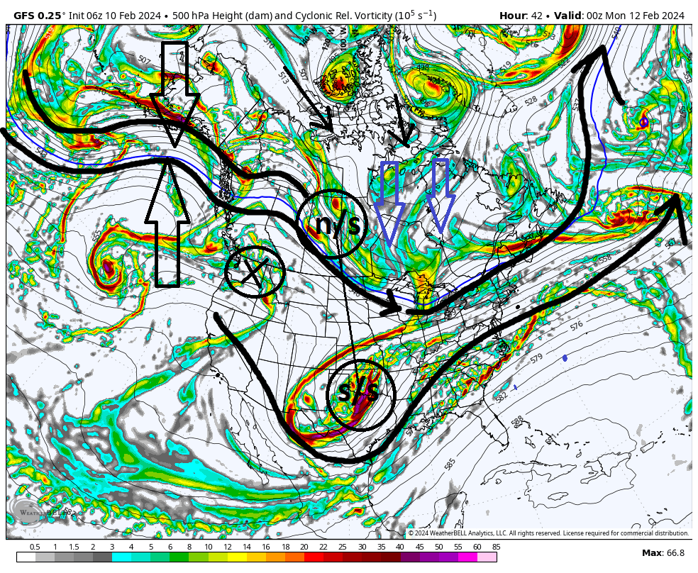
Now fast forward to approxx 2am Tues am. (see below) Now because of some of the major pattern drivers that have been outlined by a few of us, the SOI Crash, and the MJO in particular, the idea of a reshuffling of the atmopshere is really showing up. In the prev map above that area in the GOA is the start of a very robust Ridge that wants to amplify quickly into the EPO region. Ths is huge because while the +PNA ridge may have been knocked down there is now an immediate response behind it such that our already gathered cold air source gets pinned where it is between this stout ridge and the 50/50 energy out over the N Atlantic. If this des not go up then an over amped s/s system, which we seem to have, would more than likely have no resistance tothe NW such that it bullies its way to our west. Instead what we seem to have developing here is our -EPO ridge going up digs a s/w down its eastern flank that actually reinforces the prev +PNA ridge such that our "mogul" ridge actually gains a little amplitude.
Key points thus far: The mogul ridge actually reinforces our n/s energy to dig towards the conus. Back to the fact that the s/s energy remains just out ahead of the n/s. The n/s stream is pressing south because of the mogul AND behind it a stout -EPO ridge is amplifying rapidly. This, combined with our 50/50-ish Low, is key to preventing an amped s/s system from bullying itself west; raising heights out ahead. Instead it appears, if this depiction comes to fruition, will keep our energy S&E of us as we hit the coast.

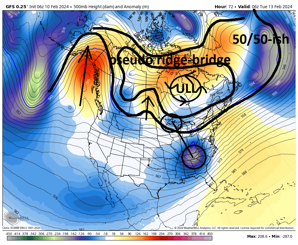
Image below is the 500mb anomaly map for the same time stamp as the one just above. Again Big -EPO ridge in the west, 50/50-ish Low triggering the development of a -NAO ridge in the east; trapping a sm lobe of the trop PV in Canada = a cold air source. The anomaly map shows the orange colors building over the top of the ULL that is our lobe of the trop PV. Its not a classic ridge bridge but its close hence pseudo ridge bridge. What ever you want to call it it pins the cold air where we need it.
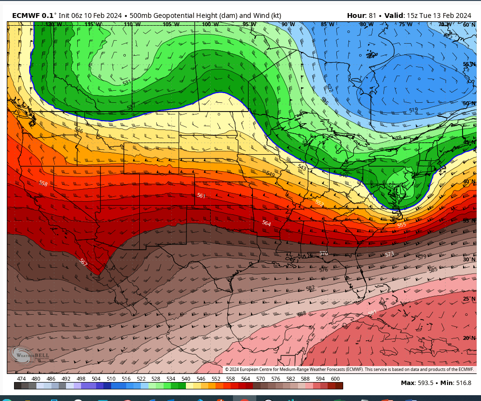
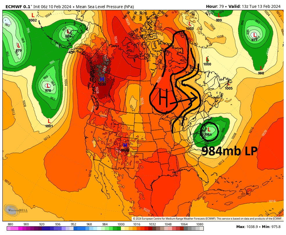
Now I want to address the idea that there is no HP to our north. This actually isnt true. There is HP to our N but its weak. Below is the euro valid for approx 8am Tuesday am. This is about when the LP exits the coast. Notice its already sitting at about 984mb as it exits the coast. All three models, euro, gfs, cmc, have the sLP at or around this strength exiting the coast. While this is happening you can see I outlined where our HP is to our N. The area under the H is approx 1020mb and the area that extends east drops to approx mid 10-teens +/-.
Here is the thing. When it comes to a storm coming off the coast in order to tap into the cold Canadian air mass that we have established is pinned in place by the aforementioned features, all you need is a gradient. If your gradient between HP and LP is steep enough you will move air from areas of HP to areas of LP. If you have 995-1000 mb LP exiting the coast and deepening with a stout 1030mb HP to the north you have a difference of about 30-35mb. However if you have a 985mb low exiting the coast and deepening with a 1015mb HP to the north you still have a 30mb difference. What does that mean? It means the movement of air is approx equal between both examples. So while we dont have this clear cut stout textbook HP to our north, we have the gradient necessary to draw in the more than sufficiently cold air source from our north.
So the last piece to the puzzle involves the mechanism for why we have such a storm storm exiting the coast, and why it is rapidly deepening. The main player involves a dual jet streak structure(see below) in the upper levels. For more details on what a jet streak is go here ( Jet Streak)
What you need to know is that the area in the R rear quadrant, and the left front quadrant of an upper level Jet streak, there is enhanced vertical m0tion at the surface. If you notice in the image below, because we have a dual jet streak, both the left front quad of the southern JS, and the R Rear quad of the Northern JS overlap meaning, there is essentially double the vertical forcing mechanisms. Our area is right in the middle of these overlapping quads of a dual jet structure. Combined with an already amped s/s system we get a rapid deepening of the system as it comes off the coast. On top of this right at the last min models are starting to hint at some potential n/s and s/s interactions.

So...We are not home yet. Some of these things I outlined are just starting to come into alignment between the major models, as well as the timing too. But we are still 60-72 hrs from actual game time. ALL the key players have just gotten onto the field this am. So the fine tuning of the details will come into focus today, into tomorrow and through tomorrow night to early morn Monday. The entire area, including the coastal plain, is still very much in the game for a 6+ event, but Id caution getting too excited just yet.
We track

_________________
"In weather and in life, there's no winning and losing; there's only winning and learning."
WINTER 2012/2013 TOTALS 43.65"WINTER 2017/2018 TOTALS 62.85" WINTER 2022/2023 TOTALS 4.9"
WINTER 2013/2014 TOTALS 64.85"WINTER 2018/2019 TOTALS 14.25" WINTER 2023/2024 TOTALS 13.1"
WINTER 2014/2015 TOTALS 71.20"WINTER 2019/2020 TOTALS 6.35"
WINTER 2015/2016 TOTALS 35.00"WINTER 2020/2021 TOTALS 37.75"
WINTER 2016/2017 TOTALS 42.25"WINTER 2021/2022 TOTALS 31.65"

sroc4- Admin

- Posts : 8354
Reputation : 302
Join date : 2013-01-07
Location : Wading River, LI
docstox12, kalleg, nancy-j-s, dolphins222, jmanley32, heehaw453, weatherwatchermom and like this post
 Re: February 12th-13th 2024 Pre-Valentines Day Storm Potential
SROC, this is a wonderful analysis. Liked your comparison of the northern jet stream to a mogul ski slope (excellent visual) and your point about the HP/LP gradient was great.
JT33- Posts : 42
Reputation : 0
Join date : 2022-01-25
Location : Piscataway
sroc4, docstox12, kalleg, nancy-j-s and weatherwatchermom like this post
 Re: February 12th-13th 2024 Pre-Valentines Day Storm Potential
Gfs rolling. Nam and Rgem keep the mid level energy south because of the press from the north. 2-3 days out and a tendency for things to come NW last minute bodes well….for now
_________________
"In weather and in life, there's no winning and losing; there's only winning and learning."
WINTER 2012/2013 TOTALS 43.65"WINTER 2017/2018 TOTALS 62.85" WINTER 2022/2023 TOTALS 4.9"
WINTER 2013/2014 TOTALS 64.85"WINTER 2018/2019 TOTALS 14.25" WINTER 2023/2024 TOTALS 13.1"
WINTER 2014/2015 TOTALS 71.20"WINTER 2019/2020 TOTALS 6.35"
WINTER 2015/2016 TOTALS 35.00"WINTER 2020/2021 TOTALS 37.75"
WINTER 2016/2017 TOTALS 42.25"WINTER 2021/2022 TOTALS 31.65"

sroc4- Admin

- Posts : 8354
Reputation : 302
Join date : 2013-01-07
Location : Wading River, LI
nancy-j-s likes this post
 Re: February 12th-13th 2024 Pre-Valentines Day Storm Potential
Nice analysis sroc. Didn't realize you created a thread on this before i added a few posts in the LR. I think another point here is the consolidation factor. Warm tongues are less likely with closed off mid-levels 850/700. Disorganized storms where the energy is spread out it's more likely. I would prefer something in between GFS/GGEM. I think the GFS is too aggressive and matures the s/s storm too quickly for my liking.
heehaw453- Advanced Forecaster

- Posts : 3906
Reputation : 86
Join date : 2014-01-20
Location : Bedminster Township, PA Elevation 600' ASL
sroc4 likes this post
 Re: February 12th-13th 2024 Pre-Valentines Day Storm Potential
sroc4 wrote:Gfs rolling. Nam and Rgem keep the mid level energy south because of the press from the north. 2-3 days out and a tendency for things to come NW last minute bodes well….for now
I don't think the GGEM is affected by the press from the north in so much as the ULL doesn't mature nearly like the GFS. That keeps the mid-levels from riding higher. The GGEM ridge is smoother which probably affects the development.


heehaw453- Advanced Forecaster

- Posts : 3906
Reputation : 86
Join date : 2014-01-20
Location : Bedminster Township, PA Elevation 600' ASL
 Re: February 12th-13th 2024 Pre-Valentines Day Storm Potential
heehaw453 wrote:sroc4 wrote:Gfs rolling. Nam and Rgem keep the mid level energy south because of the press from the north. 2-3 days out and a tendency for things to come NW last minute bodes well….for now
I don't think the GGEM is affected by the press from the north in so much as the ULL doesn't mature nearly like the GFS. That keeps the mid-levels from riding higher. The GGEM ridge is smoother which probably affects the development.
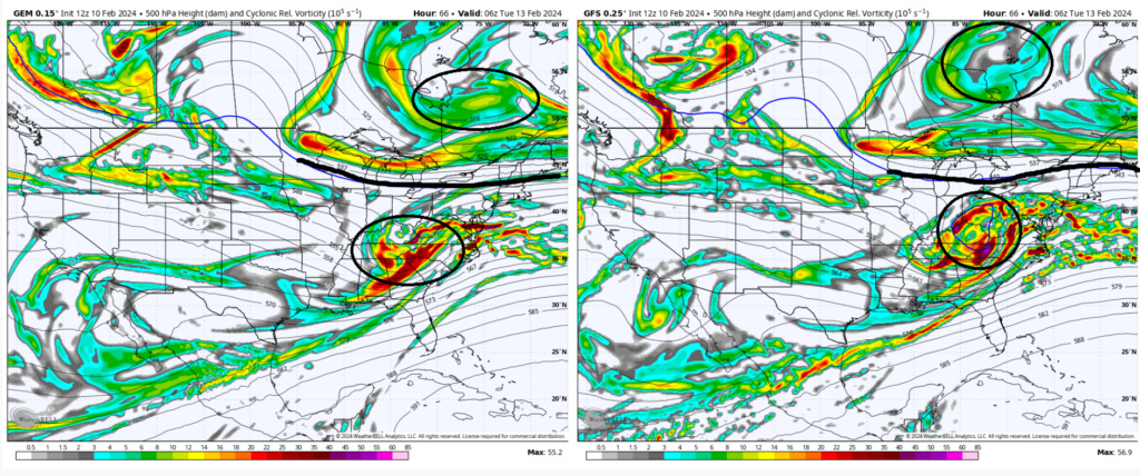
Im sure thats true but I think whats also true is positioning of the TPV. GFS clearly centered furthe N compared to the CMC. Result is a stronger press and flatter flow and a less organized s/s. Or like you said is a weaker, less organized s/s system on the cmc allow for the press further south compared to the stronger s/s system on the gfs which pushes back on the press? OR is it a combination of the two. My guess its a combination of the two in reality. either way cmc has confluence about 75-100miles further south, making all the difference.
_________________
"In weather and in life, there's no winning and losing; there's only winning and learning."
WINTER 2012/2013 TOTALS 43.65"WINTER 2017/2018 TOTALS 62.85" WINTER 2022/2023 TOTALS 4.9"
WINTER 2013/2014 TOTALS 64.85"WINTER 2018/2019 TOTALS 14.25" WINTER 2023/2024 TOTALS 13.1"
WINTER 2014/2015 TOTALS 71.20"WINTER 2019/2020 TOTALS 6.35"
WINTER 2015/2016 TOTALS 35.00"WINTER 2020/2021 TOTALS 37.75"
WINTER 2016/2017 TOTALS 42.25"WINTER 2021/2022 TOTALS 31.65"

sroc4- Admin

- Posts : 8354
Reputation : 302
Join date : 2013-01-07
Location : Wading River, LI
 Re: February 12th-13th 2024 Pre-Valentines Day Storm Potential
GEFS


_________________
"In weather and in life, there's no winning and losing; there's only winning and learning."
WINTER 2012/2013 TOTALS 43.65"WINTER 2017/2018 TOTALS 62.85" WINTER 2022/2023 TOTALS 4.9"
WINTER 2013/2014 TOTALS 64.85"WINTER 2018/2019 TOTALS 14.25" WINTER 2023/2024 TOTALS 13.1"
WINTER 2014/2015 TOTALS 71.20"WINTER 2019/2020 TOTALS 6.35"
WINTER 2015/2016 TOTALS 35.00"WINTER 2020/2021 TOTALS 37.75"
WINTER 2016/2017 TOTALS 42.25"WINTER 2021/2022 TOTALS 31.65"

sroc4- Admin

- Posts : 8354
Reputation : 302
Join date : 2013-01-07
Location : Wading River, LI
 Re: February 12th-13th 2024 Pre-Valentines Day Storm Potential
12Z Euro. Similar to GFS. It's too amped up for my liking. This area doesn't want h850 passing over Central NJ. You want this passing over Cape May or east of there. Luckily it's 72 hours out and there's enough uncertainty such that there is a at least 100 mile margin of error with this now. Track the the mid-levels...


heehaw453- Advanced Forecaster

- Posts : 3906
Reputation : 86
Join date : 2014-01-20
Location : Bedminster Township, PA Elevation 600' ASL
 Re: February 12th-13th 2024 Pre-Valentines Day Storm Potential
heehaw453 wrote:12Z Euro. Similar to GFS. It's too amped up for my liking. This area doesn't want h850 passing over Central NJ. You want this passing over Cape May or east of there. Luckily it's 72 hours out and there's enough uncertainty such that there is a at least 100 mile margin of error with this now. Track the the mid-levels...
Would this be a good outcome for those of us 40-70 miles or more north of the city? Or to far north even for us.

CPcantmeasuresnow- Wx Statistician Guru

- Posts : 7274
Reputation : 230
Join date : 2013-01-07
Age : 103
Location : Eastern Orange County, NY
 Re: February 12th-13th 2024 Pre-Valentines Day Storm Potential
Another perspective. Note ULL has closed off but we're not under it, but inside of it. All that does is ensure mid-levels are passing over NJ. Now what gives me cause to pause on this track is the TPV above it. Either the storm matures a bit later or the TPV presses a bit more. Both are very possible.
But verbatim this 12Z solution is crap for 90% of the folks on this board.

But verbatim this 12Z solution is crap for 90% of the folks on this board.

Last edited by heehaw453 on Sat Feb 10, 2024 4:38 pm; edited 1 time in total
heehaw453- Advanced Forecaster

- Posts : 3906
Reputation : 86
Join date : 2014-01-20
Location : Bedminster Township, PA Elevation 600' ASL
 Re: February 12th-13th 2024 Pre-Valentines Day Storm Potential
CPcantmeasuresnow wrote:heehaw453 wrote:12Z Euro. Similar to GFS. It's too amped up for my liking. This area doesn't want h850 passing over Central NJ. You want this passing over Cape May or east of there. Luckily it's 72 hours out and there's enough uncertainty such that there is a at least 100 mile margin of error with this now. Track the the mid-levels...
Would this be a good outcome for those of us 40-70 miles or more north of the city? Or to far north even for us.
It might CP and I'm being egocentric when I speak of this solution for MBY. I think even your area though would have poor ratios and possibly mixing concerns with this solution. It's just too far north for 90% of the board members.
heehaw453- Advanced Forecaster

- Posts : 3906
Reputation : 86
Join date : 2014-01-20
Location : Bedminster Township, PA Elevation 600' ASL
docstox12 and CPcantmeasuresnow like this post
heehaw453- Advanced Forecaster

- Posts : 3906
Reputation : 86
Join date : 2014-01-20
Location : Bedminster Township, PA Elevation 600' ASL
heehaw453- Advanced Forecaster

- Posts : 3906
Reputation : 86
Join date : 2014-01-20
Location : Bedminster Township, PA Elevation 600' ASL
 Re: February 12th-13th 2024 Pre-Valentines Day Storm Potential
Weather Alert
Winter Storm Watch issued February 10 at 3:17PM EST until February 13 at 6:00PM EST by NWS Upton NY
* WHAT...Heavy snow possible. Total snow accumulations of 6 to 8 inches with higher amounts around 10 inches possible across the higher elevations. * WHERE...Portions of southern Connecticut
A warning is issued when a hazardous weather or hydrologic event is occurring, imminent or likely.
A watch is used when the risk of a hazardous weather or hydrologic event has increased significantly, but its occurrence, location or timing is still uncertain.
An advisory is issued when a hazardous weather or hydrologic event is occurring, imminent or likely.

Artechmetals- Pro Enthusiast

- Posts : 571
Reputation : 3
Join date : 2014-01-01
Age : 57
Location : Wayne , NJ
 Re: February 12th-13th 2024 Pre-Valentines Day Storm Potential
NWS just posted WSW for my area. Calling for 7-12 inches .
Last edited by SNOW MAN on Sat Feb 10, 2024 4:14 pm; edited 1 time in total

SNOW MAN- Senior Enthusiast

- Posts : 1361
Reputation : 25
Join date : 2013-01-13
Age : 64
Location : Marshalls Creek Pa.
docstox12 and hyde345 like this post
 Re: February 12th-13th 2024 Pre-Valentines Day Storm Potential
A winter storm watch was issued by the National Weather Service on Saturday at 3:17 p.m. valid for Tuesday between 1 a.m. and 6 p.m. for Passaic and Bergen counties.
The weather service adds, "Heavy snow possible. Total snow accumulations of 6 to 8 inches with higher amounts around 10 inches possible across the higher elevations."
The weather service adds, "Heavy snow possible. Total snow accumulations of 6 to 8 inches with higher amounts around 10 inches possible across the higher elevations."

Artechmetals- Pro Enthusiast

- Posts : 571
Reputation : 3
Join date : 2014-01-01
Age : 57
Location : Wayne , NJ
hyde345 likes this post
 Re: February 12th-13th 2024 Pre-Valentines Day Storm Potential
48 hrs out guess they seem confident

Artechmetals- Pro Enthusiast

- Posts : 571
Reputation : 3
Join date : 2014-01-01
Age : 57
Location : Wayne , NJ
 Re: February 12th-13th 2024 Pre-Valentines Day Storm Potential
WSW issued for Mid HV and NW CT for 6-9 inches.

hyde345- Pro Enthusiast

- Posts : 1082
Reputation : 48
Join date : 2013-01-08
Location : Hyde Park, NY
docstox12 likes this post
 Re: February 12th-13th 2024 Pre-Valentines Day Storm Potential
heehaw453 wrote:Another perspective. Note ULL has closed off but we're not under it, but inside of it. All that does is ensure mid-levels are passing over NJ. Now what gives me cause to pause on this track is the TPV above it. Either the storm matures a bit later or the TPV presses a bit more. Both are very possible.
But verbatim this 12Z solution is crap for 90% of the folks on this board.
Looks like you may have inadvertently posted the 06z map.
_________________
"In weather and in life, there's no winning and losing; there's only winning and learning."
WINTER 2012/2013 TOTALS 43.65"WINTER 2017/2018 TOTALS 62.85" WINTER 2022/2023 TOTALS 4.9"
WINTER 2013/2014 TOTALS 64.85"WINTER 2018/2019 TOTALS 14.25" WINTER 2023/2024 TOTALS 13.1"
WINTER 2014/2015 TOTALS 71.20"WINTER 2019/2020 TOTALS 6.35"
WINTER 2015/2016 TOTALS 35.00"WINTER 2020/2021 TOTALS 37.75"
WINTER 2016/2017 TOTALS 42.25"WINTER 2021/2022 TOTALS 31.65"

sroc4- Admin

- Posts : 8354
Reputation : 302
Join date : 2013-01-07
Location : Wading River, LI
 Re: February 12th-13th 2024 Pre-Valentines Day Storm Potential
sroc4 wrote:heehaw453 wrote:Another perspective. Note ULL has closed off but we're not under it, but inside of it. All that does is ensure mid-levels are passing over NJ. Now what gives me cause to pause on this track is the TPV above it. Either the storm matures a bit later or the TPV presses a bit more. Both are very possible.
But verbatim this 12Z solution is crap for 90% of the folks on this board.
Looks like you may have inadvertently posted the 06z map.
You're right. Updated it.
heehaw453- Advanced Forecaster

- Posts : 3906
Reputation : 86
Join date : 2014-01-20
Location : Bedminster Township, PA Elevation 600' ASL
sroc4 likes this post
 Re: February 12th-13th 2024 Pre-Valentines Day Storm Potential
WSW for Monday night 6-10 inches in Orange County. Will be hard pressed to surpass the 9.5 I got in January 7th storm.
Plus I'm still buying this on yet, 3-5 seems more likely.
Plus I'm still buying this on yet, 3-5 seems more likely.

CPcantmeasuresnow- Wx Statistician Guru

- Posts : 7274
Reputation : 230
Join date : 2013-01-07
Age : 103
Location : Eastern Orange County, NY
docstox12 and dkodgis like this post
 Re: February 12th-13th 2024 Pre-Valentines Day Storm Potential
Does anyone know how much snow I am getting for my area in the Bronx?
frank 638- Senior Enthusiast

- Posts : 2843
Reputation : 37
Join date : 2016-01-01
Age : 40
Location : bronx ny
 Re: February 12th-13th 2024 Pre-Valentines Day Storm Potential
On the 18z runs the GFS was maybe a tick south, but not much, pretty similar to 12z run. The 18z NAM is still demonstrably colder/more south than the GFS as it has been since last night when it came into range.

billg315- Advanced Forecaster - Mod

- Posts : 4483
Reputation : 185
Join date : 2015-01-24
Age : 50
Location : Flemington, NJ
 Re: February 12th-13th 2024 Pre-Valentines Day Storm Potential
Winter Storm Watch for Hunterdon Co NJ. Which is interesting because the forecast atm (2-4”) is not Watch criteria. It appears they’re issuing it because they’re hedging their bets that an outcome line the NAM could come to fruition which would be over 6” here. Shows an unusual amount of uncertainty for them as typically they’d just issue an Advisory if they were all-in in the more modest amounts and upgrade later if necessary.

billg315- Advanced Forecaster - Mod

- Posts : 4483
Reputation : 185
Join date : 2015-01-24
Age : 50
Location : Flemington, NJ
 Re: February 12th-13th 2024 Pre-Valentines Day Storm Potential
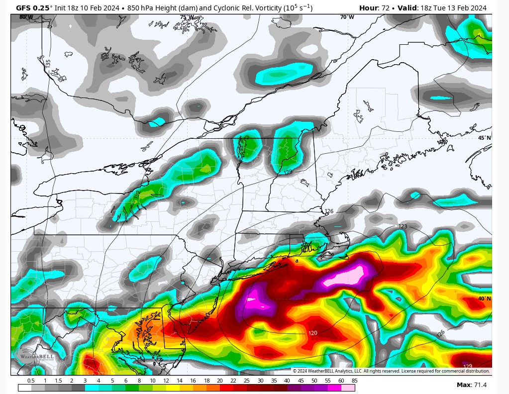
There's definitely uncertainty with this. Here (18Z GFS) you have a full maturation of the mid-levels (first picture). If that occurs 50 miles south west then that puts the I95 (TTN-NYC) in the axis of heavier snow. Note last night's GFS 00Z 850 vorticity and the difference of say 50 miles in the maturation process from what it's showing now.
As is it's close, but IMO blossoms a little too late for I95/coastal plain as it's right on the BM. An efficient transfer that allow for the mid-levels to start closing off and maturing around Cape May/DE is what's needed for I95/Coastal Plain. What we're seeing now is the maturation take a little longer and the mid-levels ride a bit further north.
As a rule of thumb you want to be on the NW side of the mid-levels during their maturation. Parallel doesn't work.


heehaw453- Advanced Forecaster

- Posts : 3906
Reputation : 86
Join date : 2014-01-20
Location : Bedminster Township, PA Elevation 600' ASL
Page 1 of 13 • 1, 2, 3 ... 11, 12, 13 
Page 1 of 13
Permissions in this forum:
You cannot reply to topics in this forum|
|
|

 Home
Home

