
 Search
Official Long Range Thread 2.0
Page 8 of 41 •  1 ... 5 ... 7, 8, 9 ... 24 ... 41
 ![]()
Re: Official Long Range Thread 2.0
![]() by jmanley32 Tue Feb 25, 2014 3:08 pm
by jmanley32 Tue Feb 25, 2014 3:08 pm
jmanley32- Senior Enthusiast

- Posts : 20513
Join date : 2013-12-12
Re: Official Long Range Thread 2.0
![]() by Math23x7 Tue Feb 25, 2014 3:14 pm
by Math23x7 Tue Feb 25, 2014 3:14 pm
Math23x7- Wx Statistician Guru

- Posts : 2379
Join date : 2013-01-08
Re: Official Long Range Thread 2.0
![]() by CPcantmeasuresnow Tue Feb 25, 2014 3:15 pm
by CPcantmeasuresnow Tue Feb 25, 2014 3:15 pm
Not getting my hopes up yet for this, but Frank seems to think something has been brewing in this time period and he's been saying it for awhile. Now the models are following Frank.

CPcantmeasuresnow- Wx Statistician Guru
- Posts : 7274
Reputation : 230
Join date : 2013-01-07
Age : 103
Location : Eastern Orange County, NY
Re: Official Long Range Thread 2.0
![]() by jmanley32 Tue Feb 25, 2014 3:17 pm
by jmanley32 Tue Feb 25, 2014 3:17 pm

jmanley32- Senior Enthusiast
- Posts : 20513
Reputation : 108
Join date : 2013-12-12
Age : 42
Location : Yonkers, NY
Re: Official Long Range Thread 2.0
![]() by SNOW MAN Tue Feb 25, 2014 3:23 pm
by SNOW MAN Tue Feb 25, 2014 3:23 pm
CPcantmeasuresnow wrote:Jman:
Not getting my hopes up yet for this, but Frank seems to think something has been brewing in this time period and he's been saying it for awhile. Now the models are following Frank.
Come on Cp you know your heart rates starting to pick up a little. Do you know why ? Because you are a SUPER SNOW WEENIE and you just can't help it.
I know mine has started to race just a bit. LOL !

SNOW MAN- Senior Enthusiast
- Posts : 1361
Reputation : 25
Join date : 2013-01-13
Age : 64
Location : Marshalls Creek Pa.
Re: Official Long Range Thread 2.0
![]() by sroc4 Tue Feb 25, 2014 3:35 pm
by sroc4 Tue Feb 25, 2014 3:35 pm
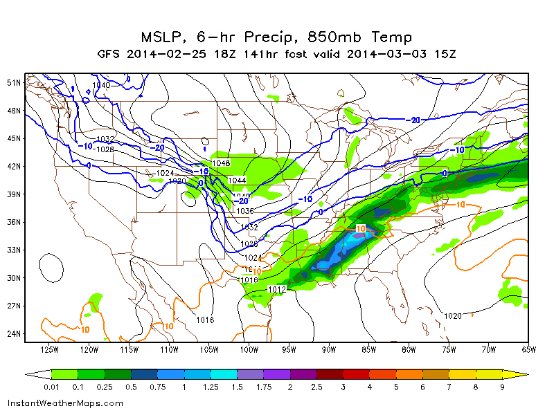
The main difference in the southern branch between the GFS vs the CMC/Euro is look how strung out the southern energy is on the GFS. Although differences in placement and intensity the CMC and Euro both seem to concentrate the southern energy better. I believe this leads to development of LP along the boundary layer which enhances the precip on the surface maps.
I am not 100% exactly what these things truly mean however. For instance. If the GFS were right about the weakness in the northern energy above the GL and the trailing s/w diving into the N plains does not have that connection with the PV as is depicted by the CMC and Euro does that lead to a faster flow to the STJ?? If so is it because the SE ridge builds in slightly stronger, so therefore, the southern energy is more strung out which leads to a weak overrunning event and a weak precip shield because there just isn't any focus of energy to spawn LP along the boundary layer as depicted by the 12z? If the CMC and Euro are right about that connection in the northern stream with the PV does that mean the boundary layer sets up a tad further south, and does this lead to a slightly slower STJ which leads to a more focused soln to the energy in the STJ which in turn leads to LP development and enhanced precip? I would love to hear others opinions on that.
 " />
" /> " />
" /> " />
" />Bottom line all three models still have large differences between them and these solns will change so for now we sit and watch. And as Tom said above look for trends and consistencies at 500mb first. Then and only then should we worry about precip amts, temp profiles etc. Personally I think we should not give this threat a thread until under 5 days. That's just me being superstitious however.
_________________
"In weather and in life, there's no winning and losing; there's only winning and learning."
WINTER 2012/2013 TOTALS 43.65"WINTER 2017/2018 TOTALS 62.85" WINTER 2022/2023 TOTALS 4.9"
WINTER 2013/2014 TOTALS 64.85"WINTER 2018/2019 TOTALS 14.25" WINTER 2023/2024 TOTALS 13.1"
WINTER 2014/2015 TOTALS 71.20"WINTER 2019/2020 TOTALS 6.35"
WINTER 2015/2016 TOTALS 35.00"WINTER 2020/2021 TOTALS 37.75"
WINTER 2016/2017 TOTALS 42.25"WINTER 2021/2022 TOTALS 31.65"

sroc4- Admin

- Posts : 8331
Reputation : 301
Join date : 2013-01-07
Location : Wading River, LI
Re: Official Long Range Thread 2.0
![]() by Dunnzoo Tue Feb 25, 2014 3:40 pm
by Dunnzoo Tue Feb 25, 2014 3:40 pm
_________________
Janet
Snowfall winter of 2023-2024 17.5"
Snowfall winter of 2022-2023 6.0"
Snowfall winter of 2021-2022 17.6" 1" sleet 2/25/22
Snowfall winter of 2020-2021 51.1"
Snowfall winter of 2019-2020 8.5"
Snowfall winter of 2018-2019 25.1"
Snowfall winter of 2017-2018 51.9"
Snowfall winter of 2016-2017 45.6"
Snowfall winter of 2015-2016 29.5"
Snowfall winter of 2014-2015 50.55"
Snowfall winter of 2013-2014 66.5"

Dunnzoo- Senior Enthusiast - Mod

- Posts : 4890
Reputation : 68
Join date : 2013-01-11
Age : 62
Location : Westwood, NJ
Re: Official Long Range Thread 2.0
![]() by amugs Tue Feb 25, 2014 4:25 pm
by amugs Tue Feb 25, 2014 4:25 pm
Really, Great right up and it is 5-6 days away so we can chill out - literally with our cold, fzard pattern. The energy comes onshore Friday in Cali and then we strat to see the models sample this energy better.
I read that the SST's of the Pac are warming of the mid lattitudes and that we are seemingly heading into an El Nino pattern - the STJ will not be raging for this storm but should be increasing as we move through March bringing a lot of moisture into the CONUS and on another note bring severe weather with it as well.
Tom is just pissed cause he may have to change his flight out of this tundra no matter what he says- HAHAHA!
Let's not jump ship if the models lose this for a run or two the next day or two as well - that PV is an important player and the confluence is going to also be key. i feel the STJ will be there for us as we move forward and the temp gradient in the plains (did anyone see this -35C in the north to +25C in the central/south - Insane!). Let's hope the gradient set ups just right for us and not too far south. We shall see.....
_________________
Mugs
AKA:King: Snow Weenie
Self Proclaimed
WINTER 2014-15 : 55.12" +.02 for 6 coatings (avg. 35")
WINTER 2015-16 Total - 29.8" (Avg 35")
WINTER 2016-17 : 39.5" so far

amugs- Advanced Forecaster - Mod
- Posts : 15093
Reputation : 213
Join date : 2013-01-07
Age : 54
Location : Hillsdale,NJ
Re: Official Long Range Thread 2.0
![]() by amugs Tue Feb 25, 2014 4:27 pm
by amugs Tue Feb 25, 2014 4:27 pm
Phenomenal synoptic pattern as depicted on today's 12z ECMWF ensembles for this storm threat. I've illustrated the features on the map.
Strong -EPO block, retrograding west based positive height anomaly near Greenland/north of HB. PV and associated confluent flow, which will ultimately serve as the catalyst for any energy transfer to the mid atlantic coast. Western trough induced thermal gradient / baroclinic zone running Plains to East Coast. A similar set-up to the post superbowl storm, and many of our December events, but better in the NAO region.

_________________
Mugs
AKA:King: Snow Weenie
Self Proclaimed
WINTER 2014-15 : 55.12" +.02 for 6 coatings (avg. 35")
WINTER 2015-16 Total - 29.8" (Avg 35")
WINTER 2016-17 : 39.5" so far
amugs- Advanced Forecaster - Mod
- Posts : 15093
Reputation : 213
Join date : 2013-01-07
Age : 54
Location : Hillsdale,NJ
Re: Official Long Range Thread 2.0
![]() by NjWeatherGuy Tue Feb 25, 2014 4:30 pm
by NjWeatherGuy Tue Feb 25, 2014 4:30 pm
amugs wrote:The GFS is a party pooper IMO as a SUPER SNOW WEENIE!!
Really, Great right up and it is 5-6 days away so we can chill out - literally with our cold, fzard pattern. The energy comes onshore Friday in Cali and then we strat to see the models sample this energy better.
I read that the SST's of the Pac are warming of the mid lattitudes and that we are seemingly heading into an El Nino pattern - the STJ will not be raging for this storm but should be increasing as we move through March bringing a lot of moisture into the CONUS and on another note bring severe weather with it as well.
Tom is just pissed cause he may have to change his flight out of this tundra no matter what he says- HAHAHA!
Let's not jump ship if the models lose this for a run or two the next day or two as well - that PV is an important player and the confluence is going to also be key. i feel the STJ will be there for us as we move forward and the temp gradient in the plains (did anyone see this -35C in the north to +25C in the central/south - Insane!). Let's hope the gradient set ups just right for us and not too far south. We shall see.....
It's mostly because it's ridiculous to get excited this far out. I am excited about the potential, that's it. Trust me if the 2 feet the CMC shows or the 12-18 the EURO shows verifies I'd be happy to change my flight. The issue is we've seen this mid-range crisis BS many times before namely 2/5, 2/9 and others. Under 100hrs around 72 the models begin to hone in on the track, we are well from that, we will be there Friday night sometime. Anyone thinking these maps are going to verify at this time are setting up for utter disappointment. I'd be a miracle to see the jackpot stay in the same exact area for 120 hours up into the event. We are not even in NAM range yet which is a red flag right off the bat. Out biggest snows this year have been storms that crept up on us in the last few days before the event. The things that have shown up on the mid-range, even with model consensus (tonight) have fizzled as the event gets closer. Bottom line is things can and WILL change. For better or for worse.

NjWeatherGuy- Advanced Forecaster

- Posts : 4100
Reputation : 28
Join date : 2013-01-06
Location : Belle Mead, NJ
Re: Official Long Range Thread 2.0
![]() by NjWeatherGuy Tue Feb 25, 2014 4:40 pm
by NjWeatherGuy Tue Feb 25, 2014 4:40 pm
http://mp1.met.psu.edu/~fxg1/ENSPRS_12z/ensloop.html
NjWeatherGuy- Advanced Forecaster
- Posts : 4100
Reputation : 28
Join date : 2013-01-06
Location : Belle Mead, NJ
Re: Official Long Range Thread 2.0
![]() by RJB8525 Tue Feb 25, 2014 4:49 pm
by RJB8525 Tue Feb 25, 2014 4:49 pm
he's said this and being stern all weekend week long now

RJB8525- Senior Enthusiast
- Posts : 1994
Reputation : 28
Join date : 2013-02-06
Age : 38
Location : Hackettstown, NJ
Re: Official Long Range Thread 2.0
![]() by NjWeatherGuy Tue Feb 25, 2014 4:52 pm
by NjWeatherGuy Tue Feb 25, 2014 4:52 pm
Upton
HIGH PRESSURE BUILDS IN BEHIND THE FRONT FRIDAY. HIGH PRESSURE MOVES
EAST...WITH A COLD FRONT APPROACHING SATURDAY. IT LOOKS LIKE THE
FRONT SETTLES TO OUR SOUTH...WITH SOME DIFFERENCES NOTED WITH EXACT
PLACEMENT...AND WITH EVENTUALLY LOW PRESSURE MOVEMENT BY SUNDAY.
TIMING AND POSITIONAL DIFFERENCES REMAIN AMONG THE GLOBAL MODELS.
AT THIS TIME...BELIEVE THAT THE FRONT REMAINS JUST TO THE SOUTH LATE
THIS WEEKEND AND THROUGH MONDAY WITH HIGH PRESSURE LOCATED TO THE
NORTH. LEANING TOWARD COLDER SOLUTIONS...THUS MORE SNOW WITH THIS
OVERRUNNING EVENT. STAY TUNED
Mt. Holly
SATURDAY NIGHT AND BEYOND...MODELS HAVE PUSHED BACK THE TIMING ON THE
INITIAL SHORT WAVE TROUGH AND WEAK WARM FRONT, NOW ARRIVING IN OUR
AREA SATURDAY NIGHT, OR ABOUT 12 HOURS SLOWER THAN THE MODEL RUNS
YESTERDAY WERE SHOWING. WITH THIS SHORT WAVE TROUGH THERE DOES
APPEAR TO BE SUFFICIENT LIFT TO WARRANT A PERIOD OF PRECIPITATION
ACROSS THE REGION. THE BIG QUESTION THROUGH THIS PERIOD WILL BE HOW
FAR NORTH THE WARM FRONT WILL GET BEFORE IT STALLS, AND POSSIBLY
RETREATS BACK SOUTH AS A COLD FRONT. BEST CASE SCENARIO FOR SPRING
WEATHER WATCHERS IS THAT THE FRONT STALLS ACROSS NORTHERN NJ AND E
CENTRAL PA SUNDAY NIGHT AND REMAINS NEARLY STATIONARY THROUGH
TUESDAY WHEN THE LOW LIFTS NORTHEAST OUT OF THE NORTHERN GULF OF
MEXICO, PULLING THE FRONT BACK SOUTH. HOWEVER, THIS SOLUTION, WHICH
IS CLOSE TO THE OPERATIONAL GFS IS FAR FROM CERTAIN. WITH A SPLIT
FLOW PATTERN IN THE TRANSITION SEASON, EXPECT TO SEE SIGNIFICANT
MODEL AND ENSEMBLE DIFFERENCES, AND THAT IS CERTAINLY THE CASE WITH
THE 12Z RUNS. THERE IS ESPECIALLY LARGE DIFFERENCES AMONG ENSEMBLE
MEMBERS AND OPERATIONAL MODELS IN THE SURFACE PATTERN. GIVEN THE
UNCERTAINTY, HAVE REMAINED CLOSE TO THE PREVIOUS FORECAST.
NjWeatherGuy- Advanced Forecaster
- Posts : 4100
Reputation : 28
Join date : 2013-01-06
Location : Belle Mead, NJ
Re: Official Long Range Thread 2.0
![]() by SoulSingMG Tue Feb 25, 2014 4:57 pm
by SoulSingMG Tue Feb 25, 2014 4:57 pm

SoulSingMG- Senior Enthusiast
- Posts : 2853
Reputation : 74
Join date : 2013-12-11
Location : Long Island City, NY
Re: Official Long Range Thread 2.0
![]() by NjWeatherGuy Tue Feb 25, 2014 4:58 pm
by NjWeatherGuy Tue Feb 25, 2014 4:58 pm
NjWeatherGuy- Advanced Forecaster
- Posts : 4100
Reputation : 28
Join date : 2013-01-06
Location : Belle Mead, NJ
Re: Official Long Range Thread 2.0
![]() by jbnyy224 Tue Feb 25, 2014 4:59 pm
by jbnyy224 Tue Feb 25, 2014 4:59 pm
jbnyy224- Posts : 83
Reputation : 0
Join date : 2013-01-11
Age : 38
Location : Brooklyn, NY
Re: Official Long Range Thread 2.0
![]() by RJB8525 Tue Feb 25, 2014 5:01 pm
by RJB8525 Tue Feb 25, 2014 5:01 pm
RJB8525- Senior Enthusiast
- Posts : 1994
Reputation : 28
Join date : 2013-02-06
Age : 38
Location : Hackettstown, NJ
Re: Official Long Range Thread 2.0
![]() by NjWeatherGuy Tue Feb 25, 2014 5:02 pm
by NjWeatherGuy Tue Feb 25, 2014 5:02 pm
RJB8525 wrote:this one will hit hard. march,cold potential major storm beginning of work wee with m-w time frame..not good so far either way even if its 1/4 of projected big amounts
Could be a complete rainstorm according to some GEFS members, too early...
NjWeatherGuy- Advanced Forecaster
- Posts : 4100
Reputation : 28
Join date : 2013-01-06
Location : Belle Mead, NJ
Re: Official Long Range Thread 2.0
![]() by SoulSingMG Tue Feb 25, 2014 5:03 pm
by SoulSingMG Tue Feb 25, 2014 5:03 pm
Lol, okay, I didn't look myself at WU, just saw that and was surprised. I'm excited we've got another POTENTIAL biggie to track guys! :-D
SoulSingMG- Senior Enthusiast
- Posts : 2853
Reputation : 74
Join date : 2013-12-11
Location : Long Island City, NY

NjWeatherGuy- Advanced Forecaster
- Posts : 4100
Reputation : 28
Join date : 2013-01-06
Location : Belle Mead, NJ

NjWeatherGuy- Advanced Forecaster
- Posts : 4100
Reputation : 28
Join date : 2013-01-06
Location : Belle Mead, NJ


NjWeatherGuy- Advanced Forecaster
- Posts : 4100
Reputation : 28
Join date : 2013-01-06
Location : Belle Mead, NJ

NjWeatherGuy- Advanced Forecaster
- Posts : 4100
Reputation : 28
Join date : 2013-01-06
Location : Belle Mead, NJ
Re: Official Long Range Thread 2.0
![]() by NjWeatherGuy Tue Feb 25, 2014 5:12 pm
by NjWeatherGuy Tue Feb 25, 2014 5:12 pm

NjWeatherGuy- Advanced Forecaster
- Posts : 4100
Reputation : 28
Join date : 2013-01-06
Location : Belle Mead, NJ
Re: Official Long Range Thread 2.0
![]() by NjWeatherGuy Tue Feb 25, 2014 5:14 pm
by NjWeatherGuy Tue Feb 25, 2014 5:14 pm

So far it's been raining for 20hrs lol...
NjWeatherGuy- Advanced Forecaster
- Posts : 4100
Reputation : 28
Join date : 2013-01-06
Location : Belle Mead, NJ
Re: Official Long Range Thread 2.0
![]() by NjWeatherGuy Tue Feb 25, 2014 5:16 pm
by NjWeatherGuy Tue Feb 25, 2014 5:16 pm

Surface freezing line on the northern tip of NJ, have to say this looks too warm for this track
NjWeatherGuy- Advanced Forecaster
- Posts : 4100
Reputation : 28
Join date : 2013-01-06
Location : Belle Mead, NJ

NjWeatherGuy- Advanced Forecaster
- Posts : 4100
Reputation : 28
Join date : 2013-01-06
Location : Belle Mead, NJ
Page 8 of 41 • 1 ... 5 ... 7, 8, 9 ... 24 ... 41 ![]()
|
|
|