
 Search
March 17th-18th Storm Potential Discussion
Page 3 of 21 •  1, 2, 3, 4 ... 12 ... 21
 ![]()
Re: March 17th-18th Storm Potential Discussion
![]() by SoulSingMG Thu Mar 13, 2014 2:15 pm
by SoulSingMG Thu Mar 13, 2014 2:15 pm
SoulSingMG- Senior Enthusiast

- Posts : 2853
Join date : 2013-12-11
Re: March 17th-18th Storm Potential Discussion
![]() by SoulSingMG Thu Mar 13, 2014 2:18 pm
by SoulSingMG Thu Mar 13, 2014 2:18 pm
SoulSingMG- Senior Enthusiast
- Posts : 2853
Join date : 2013-12-11
Re: March 17th-18th Storm Potential Discussion
![]() by pdubz Thu Mar 13, 2014 2:18 pm
by pdubz Thu Mar 13, 2014 2:18 pm

pdubz- Pro Enthusiast

- Posts : 539
Reputation : 0
Join date : 2013-09-24
Age : 32
Location : Port Washington,NY (L.I)
Re: March 17th-18th Storm Potential Discussion
![]() by NjWeatherGuy Thu Mar 13, 2014 2:21 pm
by NjWeatherGuy Thu Mar 13, 2014 2:21 pm
http://mp1.met.psu.edu/~fxg1/ENSPRS_12z/ensloop.html

NjWeatherGuy- Advanced Forecaster

- Posts : 4100
Reputation : 28
Join date : 2013-01-06
Location : Belle Mead, NJ
Re: March 17th-18th Storm Potential Discussion
![]() by jmanley32 Thu Mar 13, 2014 2:52 pm
by jmanley32 Thu Mar 13, 2014 2:52 pm

jmanley32- Senior Enthusiast
- Posts : 20516
Reputation : 108
Join date : 2013-12-12
Age : 42
Location : Yonkers, NY
Re: March 17th-18th Storm Potential Discussion
![]() by NjWeatherGuy Thu Mar 13, 2014 2:54 pm
by NjWeatherGuy Thu Mar 13, 2014 2:54 pm
NjWeatherGuy- Advanced Forecaster
- Posts : 4100
Reputation : 28
Join date : 2013-01-06
Location : Belle Mead, NJ
Re: March 17th-18th Storm Potential Discussion
![]() by mako460 Thu Mar 13, 2014 3:04 pm
by mako460 Thu Mar 13, 2014 3:04 pm
mako460- Pro Enthusiast
- Posts : 346
Reputation : 4
Join date : 2013-01-09
Age : 57
Location : Gerritsen Beach Brooklyn
Re: March 17th-18th Storm Potential Discussion
![]() by Frank_Wx Thu Mar 13, 2014 3:21 pm
by Frank_Wx Thu Mar 13, 2014 3:21 pm

Notice on how the Canadian model, all the western energy moves east and there is a lot of northern stream interaction. EURO shows a minor event, as does the GFS. But the ensembles are more impressive looking. We'll know much more by tomorrow night.
_________________
_______________________________________________________________________________________________________
CLICK HERE to view NJ Strong Snowstorm Classifications

Frank_Wx- Godzilla Seeker

- Posts : 21305
Reputation : 328
Join date : 2013-01-05
Age : 31
Location : Jersey City, NJ -

Re: March 17th-18th Storm Potential Discussion
![]() by NjWeatherGuy Thu Mar 13, 2014 3:23 pm
by NjWeatherGuy Thu Mar 13, 2014 3:23 pm
mako460 wrote:Tom, wouldn't 3 1/2 days be considered a couple of days out? We are in the 72-96 hour range now.
Start time is roughly 84 hours from now if it does happen. I want the whole storm within the 72 hour range, not just the start which means tomorrow 0z we'll know a lot more, anyone got GGEM ensembles?
NjWeatherGuy- Advanced Forecaster
- Posts : 4100
Reputation : 28
Join date : 2013-01-06
Location : Belle Mead, NJ
Re: March 17th-18th Storm Potential Discussion
![]() by NjWeatherGuy Thu Mar 13, 2014 3:38 pm
by NjWeatherGuy Thu Mar 13, 2014 3:38 pm
0z


12z


NjWeatherGuy- Advanced Forecaster
- Posts : 4100
Reputation : 28
Join date : 2013-01-06
Location : Belle Mead, NJ
Re: March 17th-18th Storm Potential Discussion
![]() by Frank_Wx Thu Mar 13, 2014 3:38 pm
by Frank_Wx Thu Mar 13, 2014 3:38 pm


One thing I have noticed is that the phase is very sloppy. We need the ridge in the west to amplify more to allow the northern stream to dig. Lack of blocking in the Atlantic does not help matters, but all of our storms have been short duration this season so it's not surprising.
_________________
_______________________________________________________________________________________________________
CLICK HERE to view NJ Strong Snowstorm Classifications
Frank_Wx- Godzilla Seeker
- Posts : 21305
Reputation : 328
Join date : 2013-01-05
Age : 31
Location : Jersey City, NJ -
Re: March 17th-18th Storm Potential Discussion
![]() by jmanley32 Thu Mar 13, 2014 3:39 pm
by jmanley32 Thu Mar 13, 2014 3:39 pm
jmanley32- Senior Enthusiast
- Posts : 20516
Reputation : 108
Join date : 2013-12-12
Age : 42
Location : Yonkers, NY
Re: March 17th-18th Storm Potential Discussion
![]() by NjWeatherGuy Thu Mar 13, 2014 3:40 pm
by NjWeatherGuy Thu Mar 13, 2014 3:40 pm
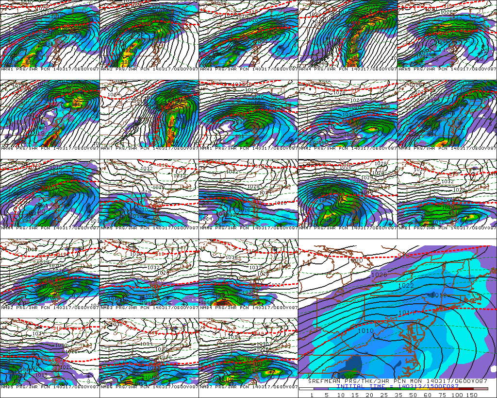
Frank_Wx wrote:GGEM Ensembles:
One thing I have noticed is that the phase is very sloppy. We need the ridge in the west to amplify more to allow the northern stream to dig. Lack of blocking in the Atlantic does not help matters, but all of our storms have been short duration this season so it's not surprising.
Yea it's like a double barrel low type deal, not a bad thing if it's far enough north, that looks fairly similar to OP with respect to the heaviest axis of precip. Like I said doesn't matter much and take with a grain of salt at this juncture.
NjWeatherGuy- Advanced Forecaster
- Posts : 4100
Reputation : 28
Join date : 2013-01-06
Location : Belle Mead, NJ
Re: March 17th-18th Storm Potential Discussion
![]() by Frank_Wx Thu Mar 13, 2014 3:41 pm
by Frank_Wx Thu Mar 13, 2014 3:41 pm

_________________
_______________________________________________________________________________________________________
CLICK HERE to view NJ Strong Snowstorm Classifications
Frank_Wx- Godzilla Seeker
- Posts : 21305
Reputation : 328
Join date : 2013-01-05
Age : 31
Location : Jersey City, NJ -
Re: March 17th-18th Storm Potential Discussion
![]() by NjWeatherGuy Thu Mar 13, 2014 3:41 pm
by NjWeatherGuy Thu Mar 13, 2014 3:41 pm
jmanley32 wrote:chances for that to come north as has been trend with the storms we have had this year?
Not lately it hasn't been the trend. I wouldn't say there's a definitive trend, seems like half trend north and half trend south when looking at all storms this winter.
NjWeatherGuy- Advanced Forecaster
- Posts : 4100
Reputation : 28
Join date : 2013-01-06
Location : Belle Mead, NJ
Re: March 17th-18th Storm Potential Discussion
![]() by NjWeatherGuy Thu Mar 13, 2014 3:43 pm
by NjWeatherGuy Thu Mar 13, 2014 3:43 pm
Frank_Wx wrote:JMA (3rd highest statistical model this winter) is a big hit
Meh I don't like this model, was showing the southern slider March 3rd storm as 1"+ QPF until the bitter end. Often way overdoes precip especially on the northern edge, verbatim with that track would be a south solution.
NjWeatherGuy- Advanced Forecaster
- Posts : 4100
Reputation : 28
Join date : 2013-01-06
Location : Belle Mead, NJ
Re: March 17th-18th Storm Potential Discussion
![]() by skinsfan1177 Thu Mar 13, 2014 3:46 pm
by skinsfan1177 Thu Mar 13, 2014 3:46 pm

skinsfan1177- Senior Enthusiast
- Posts : 4485
Reputation : 35
Join date : 2013-01-07
Age : 46
Location : Point Pleasant Boro
Re: March 17th-18th Storm Potential Discussion
![]() by Frank_Wx Thu Mar 13, 2014 3:46 pm
by Frank_Wx Thu Mar 13, 2014 3:46 pm
NjWeatherGuy wrote:Frank_Wx wrote:JMA (3rd highest statistical model this winter) is a big hit
Meh I don't like this model, was showing the southern slider March 3rd storm as 1"+ QPF until the bitter end. Often way overdoes precip especially on the northern edge, verbatim with that track would be a south solution.
It actually goes to the BM after this frame
_________________
_______________________________________________________________________________________________________
CLICK HERE to view NJ Strong Snowstorm Classifications
Frank_Wx- Godzilla Seeker
- Posts : 21305
Reputation : 328
Join date : 2013-01-05
Age : 31
Location : Jersey City, NJ -
Re: March 17th-18th Storm Potential Discussion
![]() by Frank_Wx Thu Mar 13, 2014 3:47 pm
by Frank_Wx Thu Mar 13, 2014 3:47 pm
skinsfan1177 wrote:In anyones opinion is the PV the main influence for this to come North or to go South?
PV is in a good spot. And it is elongated too, so there is a lot of confluence to prevent this storm from cutting west. I think the western pattern is more important here.
_________________
_______________________________________________________________________________________________________
CLICK HERE to view NJ Strong Snowstorm Classifications
Frank_Wx- Godzilla Seeker
- Posts : 21305
Reputation : 328
Join date : 2013-01-05
Age : 31
Location : Jersey City, NJ -
Re: March 17th-18th Storm Potential Discussion
![]() by NjWeatherGuy Thu Mar 13, 2014 3:47 pm
by NjWeatherGuy Thu Mar 13, 2014 3:47 pm
Frank_Wx wrote:NjWeatherGuy wrote:Frank_Wx wrote:JMA (3rd highest statistical model this winter) is a big hit
Meh I don't like this model, was showing the southern slider March 3rd storm as 1"+ QPF until the bitter end. Often way overdoes precip especially on the northern edge, verbatim with that track would be a south solution.
It actually goes to the BM after this frame
Really? I hate how it's only 24hrs at a time.
NjWeatherGuy- Advanced Forecaster
- Posts : 4100
Reputation : 28
Join date : 2013-01-06
Location : Belle Mead, NJ
Re: March 17th-18th Storm Potential Discussion
![]() by NjWeatherGuy Thu Mar 13, 2014 3:49 pm
by NjWeatherGuy Thu Mar 13, 2014 3:49 pm
NjWeatherGuy- Advanced Forecaster
- Posts : 4100
Reputation : 28
Join date : 2013-01-06
Location : Belle Mead, NJ
Re: March 17th-18th Storm Potential Discussion
![]() by NjWeatherGuy Thu Mar 13, 2014 4:03 pm
by NjWeatherGuy Thu Mar 13, 2014 4:03 pm
NjWeatherGuy- Advanced Forecaster
- Posts : 4100
Reputation : 28
Join date : 2013-01-06
Location : Belle Mead, NJ
Re: March 17th-18th Storm Potential Discussion
![]() by sroc4 Thu Mar 13, 2014 4:09 pm
by sroc4 Thu Mar 13, 2014 4:09 pm
_________________
"In weather and in life, there's no winning and losing; there's only winning and learning."
WINTER 2012/2013 TOTALS 43.65"WINTER 2017/2018 TOTALS 62.85" WINTER 2022/2023 TOTALS 4.9"
WINTER 2013/2014 TOTALS 64.85"WINTER 2018/2019 TOTALS 14.25" WINTER 2023/2024 TOTALS 13.1"
WINTER 2014/2015 TOTALS 71.20"WINTER 2019/2020 TOTALS 6.35"
WINTER 2015/2016 TOTALS 35.00"WINTER 2020/2021 TOTALS 37.75"
WINTER 2016/2017 TOTALS 42.25"WINTER 2021/2022 TOTALS 31.65"

sroc4- Admin
- Posts : 8331
Reputation : 301
Join date : 2013-01-07
Location : Wading River, LI
Re: March 17th-18th Storm Potential Discussion
![]() by NjWeatherGuy Thu Mar 13, 2014 4:11 pm
by NjWeatherGuy Thu Mar 13, 2014 4:11 pm
sroc4 wrote:Im with Tom in my skepticism. Although we saw some nice trends today with the GFS, the CMC also trended south from its most amped soln, and the Euro is a tad further south as well. Going back to my original write up at the begging of this thread I am concerned with this storm being the ultimate teaser with subsequent runs flirting between a mod event and a non event to our south only to have the "pattern" of the past month prevail...strong PV suppressing the system to far south leaving us on the dry northern fringe of the system which will be cold and dry making it hard for the precip to advance north leading to serious bust potential on the northern side of this storm just like 3/3. Ill believe come Sunday morning
Agree, Bernie Video. Let's see if he KOD it. I am concerned about it being a tease too, it's just too far out, trends have been good today but this far out essentially means nothing, if trends continue for the next 2 days then maybe this has some mustard.
http://www.accuweather.com/en/weather-video/next-storm-threat-for-midwest/2430839568001
NjWeatherGuy- Advanced Forecaster
- Posts : 4100
Reputation : 28
Join date : 2013-01-06
Location : Belle Mead, NJ
Re: March 17th-18th Storm Potential Discussion
![]() by sroc4 Thu Mar 13, 2014 5:02 pm
by sroc4 Thu Mar 13, 2014 5:02 pm
MODEL GUIDANCE BEGINS TO DEVIATE RIGHT OFF THE BAT DUE TO THE UNCERTAINTY WITH A NORTHERN STREAM SHORTWAVE MOVING INTO THE PAC NW ON FRI AND THE SOUTHERN STREAM TROUGH OVER THE SOUTHWEST. THE INTERACTION OF THE ENERGY ASSOCIATED WITH THESE FEATURES WILL INFLUENCE OUR WEATHER SUN NIGHT THROUGH MON. SUNYSB SENSITIVIT ANALYSIS INDICATES THE UNCERTAINTY BEGINS 24-36 HOURS FROM NOW...AND IS ASSOCIATED WITH THE HEIGHTS ACROSS WRN PORTION OF THE COUNTRY. THIS IS LENDING TO LARGE DISAGREEMENT WITH THE TROUGH AS THE TWO STREAMS MERGE IN THE LEE OF THE ROCKIES. THE ONE STRONG INDICATOR OF THIS ANALYSIS IS THAT THE EC/GFS AND CMC ENSEMBLE SYSTEMS ARE ALL INDICATING A TRACK FURTHER N THAN WHAT THE OPERATIONAL GUIDANCE IS PROVIDING. THE CMC HAS BEEN CONSISTENT OVER THE LAST FEW DAYS AND IS THE FURTHEST N WITH THE SYSTEM...SO HAVE WEIGHTED THIS WITH WPC`S GUIDANCE AS IT FIT THE SCENARIO.
WHILE IT WILL BE ANOTHER DAY OR TWO BEFORE THERE IS BETTER SAMPLING OF THE UPPER LEVEL DATA ASSOCIATED WITH THIS...TODAYS OPERATIONAL MODELS HAVE TRENDED FURTHER N...WHICH IS A STEP IN THE RIGHT DIRECTION. POLAR VORTEX OVER SE CANADA WILL PROVIDE THE COLD AIR FOR A SNOW EVENT...AND THERE IS A PERIOD OF OVERRUNNING BUT THE QUESTION REMAINS HOW FAR N DOES THE CENTER OF THE LOW (AND THE HIGHER QPF VALUES) GET. TIMING IS ALSO AN ISSUE.
_________________
"In weather and in life, there's no winning and losing; there's only winning and learning."
WINTER 2012/2013 TOTALS 43.65"WINTER 2017/2018 TOTALS 62.85" WINTER 2022/2023 TOTALS 4.9"
WINTER 2013/2014 TOTALS 64.85"WINTER 2018/2019 TOTALS 14.25" WINTER 2023/2024 TOTALS 13.1"
WINTER 2014/2015 TOTALS 71.20"WINTER 2019/2020 TOTALS 6.35"
WINTER 2015/2016 TOTALS 35.00"WINTER 2020/2021 TOTALS 37.75"
WINTER 2016/2017 TOTALS 42.25"WINTER 2021/2022 TOTALS 31.65"
sroc4- Admin
- Posts : 8331
Reputation : 301
Join date : 2013-01-07
Location : Wading River, LI
Re: March 17th-18th Storm Potential Discussion
![]() by amugs Thu Mar 13, 2014 5:05 pm
by amugs Thu Mar 13, 2014 5:05 pm
We need the ridge in the west to not get flattened out or else it will stay south so this is something we have to look at - the GGEM showed this at its 0Z run with a nice spike in the PAC = big storm for us - if we lose this we may see some snow but DC and SNJ get the storm - or we need the PV to do some dirty work IMO. The 12z GGEM showed the PAC ridge flattening out a bit
Hey I think we are close to an explosive set up that can yield us a nice if not Grand Finale Storm - just have to watch these next runs to see if we keep that western ridge - for once his past month please give us the storm and not the DC - SNJ folks - Jesus!
_________________
Mugs
AKA:King: Snow Weenie
Self Proclaimed
WINTER 2014-15 : 55.12" +.02 for 6 coatings (avg. 35")
WINTER 2015-16 Total - 29.8" (Avg 35")
WINTER 2016-17 : 39.5" so far

amugs- Advanced Forecaster - Mod

- Posts : 15093
Reputation : 213
Join date : 2013-01-07
Age : 54
Location : Hillsdale,NJ
Re: March 17th-18th Storm Potential Discussion
![]() by docstox12 Thu Mar 13, 2014 5:14 pm
by docstox12 Thu Mar 13, 2014 5:14 pm

docstox12- Wx Statistician Guru

- Posts : 8504
Reputation : 222
Join date : 2013-01-07
Age : 73
Location : Monroe NY
Page 3 of 21 • 1, 2, 3, 4 ... 12 ... 21 ![]()
|
|
|