
 Search
April 2014 Observations and Discussion
Page 9 of 10 •  1, 2, 3, 4, 5, 6, 7, 8, 9, 10
 ![]()
Re: April 2014 Observations and Discussion
![]() by amugs Wed Apr 30, 2014 7:04 pm
by amugs Wed Apr 30, 2014 7:04 pm
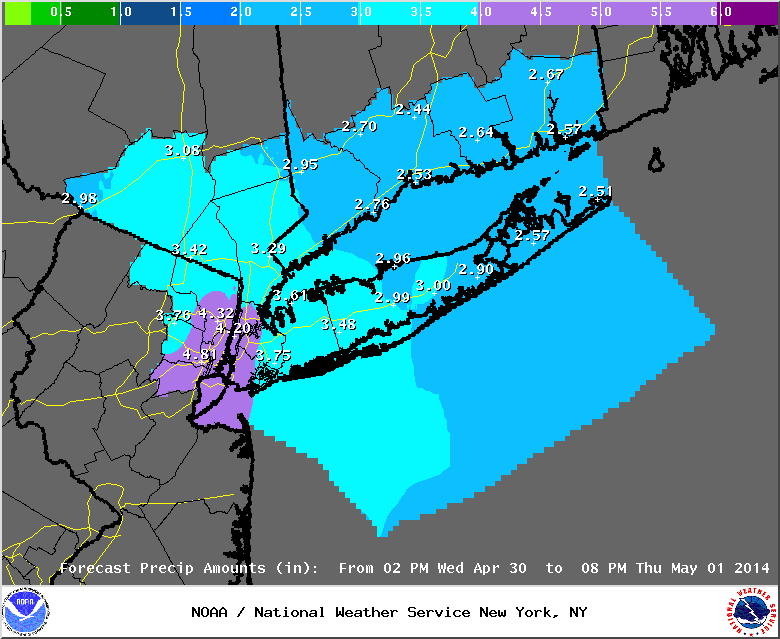
Philly over 5" so far! If that isn't impressive then I do not know what is!!
Row, Row, Row ur boat.........
amugs- Advanced Forecaster - Mod

- Posts : 15093
Join date : 2013-01-07
Re: April 2014 Observations and Discussion
![]() by amugs Wed Apr 30, 2014 7:29 pm
by amugs Wed Apr 30, 2014 7:29 pm
amugs- Advanced Forecaster - Mod
- Posts : 15093
Join date : 2013-01-07
Re: April 2014 Observations and Discussion
![]() by Dunnzoo Wed Apr 30, 2014 7:34 pm
by Dunnzoo Wed Apr 30, 2014 7:34 pm
_________________
Janet
Snowfall winter of 2023-2024 17.5"
Snowfall winter of 2022-2023 6.0"
Snowfall winter of 2021-2022 17.6" 1" sleet 2/25/22
Snowfall winter of 2020-2021 51.1"
Snowfall winter of 2019-2020 8.5"
Snowfall winter of 2018-2019 25.1"
Snowfall winter of 2017-2018 51.9"
Snowfall winter of 2016-2017 45.6"
Snowfall winter of 2015-2016 29.5"
Snowfall winter of 2014-2015 50.55"
Snowfall winter of 2013-2014 66.5"

Dunnzoo- Senior Enthusiast - Mod
- Posts : 4884
Reputation : 68
Join date : 2013-01-11
Age : 62
Location : Westwood, NJ
Re: April 2014 Observations and Discussion
![]() by SoulSingMG Wed Apr 30, 2014 7:40 pm
by SoulSingMG Wed Apr 30, 2014 7:40 pm
Dunnzoo wrote:Lee Goldberg said that it should start to lighten up about 8 pm, no way that's happening.....his futurecast was waaaayyyyyy off.
I'm so tired of Futurecast. This is NOWCAST..by reading current radar. Futurecast is barely ever on point. I'm not sure why they use it for guidance during the event.

SoulSingMG- Senior Enthusiast

- Posts : 2853
Reputation : 74
Join date : 2013-12-11
Location : Long Island City, NY
Re: April 2014 Observations and Discussion
![]() by amugs Wed Apr 30, 2014 7:52 pm
by amugs Wed Apr 30, 2014 7:52 pm
SoulSingMG wrote:Dunnzoo wrote:Lee Goldberg said that it should start to lighten up about 8 pm, no way that's happening.....his futurecast was waaaayyyyyy off.
I'm so tired of Futurecast. This is NOWCAST..by reading current radar. Futurecast is barely ever on point. I'm not sure why they use it for guidance during the event.
He must be hanging out again in that smoke shop in Denver like this past winter!!
It is 7:51 and raining hard up here.
_________________
Mugs
AKA:King: Snow Weenie
Self Proclaimed
WINTER 2014-15 : 55.12" +.02 for 6 coatings (avg. 35")
WINTER 2015-16 Total - 29.8" (Avg 35")
WINTER 2016-17 : 39.5" so far

amugs- Advanced Forecaster - Mod
- Posts : 15093
Reputation : 213
Join date : 2013-01-07
Age : 54
Location : Hillsdale,NJ
Re: April 2014 Observations and Discussion
![]() by Frank_Wx Wed Apr 30, 2014 7:56 pm
by Frank_Wx Wed Apr 30, 2014 7:56 pm
_________________
_______________________________________________________________________________________________________
CLICK HERE to view NJ Strong Snowstorm Classifications

Frank_Wx- Godzilla Seeker

- Posts : 21305
Reputation : 328
Join date : 2013-01-05
Age : 31
Location : Jersey City, NJ -

Re: April 2014 Observations and Discussion
![]() by amugs Wed Apr 30, 2014 7:58 pm
by amugs Wed Apr 30, 2014 7:58 pm
Be careful kid it is ugly out there!!Frank_Wx wrote:I do not get out of class until 9pm tonight. Gotta take the Garden State from 145 to 137. Not looking forward to that...sigh
_________________
Mugs
AKA:King: Snow Weenie
Self Proclaimed
WINTER 2014-15 : 55.12" +.02 for 6 coatings (avg. 35")
WINTER 2015-16 Total - 29.8" (Avg 35")
WINTER 2016-17 : 39.5" so far
amugs- Advanced Forecaster - Mod
- Posts : 15093
Reputation : 213
Join date : 2013-01-07
Age : 54
Location : Hillsdale,NJ
Re: April 2014 Observations and Discussion
![]() by jmanley32 Wed Apr 30, 2014 8:53 pm
by jmanley32 Wed Apr 30, 2014 8:53 pm

jmanley32- Senior Enthusiast
- Posts : 20512
Reputation : 108
Join date : 2013-12-12
Age : 42
Location : Yonkers, NY
Re: April 2014 Observations and Discussion
![]() by jmanley32 Wed Apr 30, 2014 8:57 pm
by jmanley32 Wed Apr 30, 2014 8:57 pm
jmanley32- Senior Enthusiast
- Posts : 20512
Reputation : 108
Join date : 2013-12-12
Age : 42
Location : Yonkers, NY
Re: April 2014 Observations and Discussion
![]() by Dunnzoo Wed Apr 30, 2014 8:59 pm
by Dunnzoo Wed Apr 30, 2014 8:59 pm
jmanley32 wrote:Yeah 8pm sure, look at that train! Been raining crazy here in Yonkers for many hours, havent seen much flooding but if this keeps up all night the Bronx Rover and Saw Mill will probably flood making for a nightmare of a morning commute. You all hear about that sinkhole/landslide in baltimore a entire block long taking numerous cars with it. This been one heck of a storm! Anyone know where I can find out what the totals are for my specific area so far? Would love to have a rain guage but nowhere to put since I am in a apartment on 2nd floor.
try wunderground...put in your zip and it should bring up some weather stations in your area....should be pretty close if you check a few sites....
_________________
Janet
Snowfall winter of 2023-2024 17.5"
Snowfall winter of 2022-2023 6.0"
Snowfall winter of 2021-2022 17.6" 1" sleet 2/25/22
Snowfall winter of 2020-2021 51.1"
Snowfall winter of 2019-2020 8.5"
Snowfall winter of 2018-2019 25.1"
Snowfall winter of 2017-2018 51.9"
Snowfall winter of 2016-2017 45.6"
Snowfall winter of 2015-2016 29.5"
Snowfall winter of 2014-2015 50.55"
Snowfall winter of 2013-2014 66.5"
Dunnzoo- Senior Enthusiast - Mod
- Posts : 4884
Reputation : 68
Join date : 2013-01-11
Age : 62
Location : Westwood, NJ
Re: April 2014 Observations and Discussion
![]() by jmanley32 Wed Apr 30, 2014 9:00 pm
by jmanley32 Wed Apr 30, 2014 9:00 pm
http://forecast.weather.gov/product.php?site=NWS&issuedby=OKX&product=PNS&format=CI&version=1&glossary=0
jmanley32- Senior Enthusiast
- Posts : 20512
Reputation : 108
Join date : 2013-12-12
Age : 42
Location : Yonkers, NY
Re: April 2014 Observations and Discussion
![]() by jmanley32 Wed Apr 30, 2014 9:04 pm
by jmanley32 Wed Apr 30, 2014 9:04 pm
jmanley32- Senior Enthusiast
- Posts : 20512
Reputation : 108
Join date : 2013-12-12
Age : 42
Location : Yonkers, NY
Re: April 2014 Observations and Discussion
![]() by Dunnzoo Wed Apr 30, 2014 9:09 pm
by Dunnzoo Wed Apr 30, 2014 9:09 pm
_________________
Janet
Snowfall winter of 2023-2024 17.5"
Snowfall winter of 2022-2023 6.0"
Snowfall winter of 2021-2022 17.6" 1" sleet 2/25/22
Snowfall winter of 2020-2021 51.1"
Snowfall winter of 2019-2020 8.5"
Snowfall winter of 2018-2019 25.1"
Snowfall winter of 2017-2018 51.9"
Snowfall winter of 2016-2017 45.6"
Snowfall winter of 2015-2016 29.5"
Snowfall winter of 2014-2015 50.55"
Snowfall winter of 2013-2014 66.5"
Dunnzoo- Senior Enthusiast - Mod
- Posts : 4884
Reputation : 68
Join date : 2013-01-11
Age : 62
Location : Westwood, NJ
Re: April 2014 Observations and Discussion
![]() by ClimateControl Wed Apr 30, 2014 9:11 pm
by ClimateControl Wed Apr 30, 2014 9:11 pm

ClimateControl- Posts : 29
Reputation : 0
Join date : 2014-01-02
Location : Brick, NJ (4 blocks west of Barnegat Bay)
Re: April 2014 Observations and Discussion
![]() by amugs Wed Apr 30, 2014 9:13 pm
by amugs Wed Apr 30, 2014 9:13 pm
LGA 3.68"
JFK 2.84"
EWR 3.92"
SMQ 3.52"
TTN 3.91"
Up to date rainfall amounts!!
_________________
Mugs
AKA:King: Snow Weenie
Self Proclaimed
WINTER 2014-15 : 55.12" +.02 for 6 coatings (avg. 35")
WINTER 2015-16 Total - 29.8" (Avg 35")
WINTER 2016-17 : 39.5" so far
amugs- Advanced Forecaster - Mod
- Posts : 15093
Reputation : 213
Join date : 2013-01-07
Age : 54
Location : Hillsdale,NJ
Re: April 2014 Observations and Discussion
![]() by Dunnzoo Wed Apr 30, 2014 9:18 pm
by Dunnzoo Wed Apr 30, 2014 9:18 pm
_________________
Janet
Snowfall winter of 2023-2024 17.5"
Snowfall winter of 2022-2023 6.0"
Snowfall winter of 2021-2022 17.6" 1" sleet 2/25/22
Snowfall winter of 2020-2021 51.1"
Snowfall winter of 2019-2020 8.5"
Snowfall winter of 2018-2019 25.1"
Snowfall winter of 2017-2018 51.9"
Snowfall winter of 2016-2017 45.6"
Snowfall winter of 2015-2016 29.5"
Snowfall winter of 2014-2015 50.55"
Snowfall winter of 2013-2014 66.5"
Dunnzoo- Senior Enthusiast - Mod
- Posts : 4884
Reputation : 68
Join date : 2013-01-11
Age : 62
Location : Westwood, NJ
Re: April 2014 Observations and Discussion
![]() by jmanley32 Wed Apr 30, 2014 9:30 pm
by jmanley32 Wed Apr 30, 2014 9:30 pm
jmanley32- Senior Enthusiast
- Posts : 20512
Reputation : 108
Join date : 2013-12-12
Age : 42
Location : Yonkers, NY
Re: April 2014 Observations and Discussion
![]() by jmanley32 Wed Apr 30, 2014 9:31 pm
by jmanley32 Wed Apr 30, 2014 9:31 pm
jmanley32- Senior Enthusiast
- Posts : 20512
Reputation : 108
Join date : 2013-12-12
Age : 42
Location : Yonkers, NY
Re: April 2014 Observations and Discussion
![]() by Quietace Wed Apr 30, 2014 9:41 pm
by Quietace Wed Apr 30, 2014 9:41 pm


Quietace- Meteorologist - Mod

- Posts : 3687
Reputation : 33
Join date : 2013-01-07
Age : 27
Location : Point Pleasant, NJ
Re: April 2014 Observations and Discussion
![]() by Quietace Wed Apr 30, 2014 9:47 pm
by Quietace Wed Apr 30, 2014 9:47 pm

Quietace- Meteorologist - Mod
- Posts : 3687
Reputation : 33
Join date : 2013-01-07
Age : 27
Location : Point Pleasant, NJ
Re: April 2014 Observations and Discussion
![]() by Math23x7 Wed Apr 30, 2014 10:29 pm
by Math23x7 Wed Apr 30, 2014 10:29 pm
Math23x7- Wx Statistician Guru

- Posts : 2379
Reputation : 68
Join date : 2013-01-08
Re: April 2014 Observations and Discussion
![]() by Dtone Thu May 01, 2014 6:24 am
by Dtone Thu May 01, 2014 6:24 am
Statement as of 5:04 AM EDT on May 01, 2014
...The Flood Warning remains in effect until 915 am EDT for urban areas and small streams in New York City...
* at 458 am EDT...radar showed additional heavy showers had developed over the lower boroughs of New York City.
* The Bronx river had crested at 3.7 feet...which is moderate flood stage. The river should begin to recede...and may fall below flood stage by late morning.
Dtone- Wx Statistician Guru
- Posts : 1738
Reputation : 9
Join date : 2013-08-26
Location : Bronx, NY
Re: April 2014 Observations and Discussion
![]() by Dtone Thu May 01, 2014 7:01 am
by Dtone Thu May 01, 2014 7:01 am
NY Botanical Garden has 5.19" yday + this morn. One of the better weather stations for northern bx & extreme southern Westchester.
Dtone- Wx Statistician Guru
- Posts : 1738
Reputation : 9
Join date : 2013-08-26
Location : Bronx, NY
Re: April 2014 Observations and Discussion
![]() by amugs Thu May 01, 2014 10:19 am
by amugs Thu May 01, 2014 10:19 am
NATIONAL WEATHER SERVICE NEW YORK NY
659 AM EDT THU MAY 01 2014
THE FOLLOWING ARE UNOFFICIAL OBSERVATIONS TAKEN DURING THE RECENT
STORM THAT HAS BEEN AFFECTING OUR REGION. APPRECIATION IS EXTENDED TO
HIGHWAY DEPARTMENTS...COOPERATIVE OBSERVERS...SKYWARN SPOTTERS AND
MEDIA FOR THESE REPORTS. THIS SUMMARY IS ALSO AVAILABLE ON OUR HOME
PAGE AT WEATHER.GOV/NYC
********************STORM TOTAL RAINFALL********************
LOCATION STORM TOTAL TIME/DATE COMMENTS
RAINFALL OF
/INCHES/ MEASUREMENT
CONNECTICUT
...FAIRFIELD COUNTY...
NORWALK 4.52 630 AM 5/01 PUBLIC
BRIDGEPORT AIRPORT 3.96 616 AM 5/01 ASOS
STAMFORD 3.80 600 AM 5/01 MESONET
SHELTON 3.40 530 AM 5/01 PUBLIC
DANBURY AIRPORT 2.78 621 AM 5/01 ASOS
...NEW HAVEN COUNTY...
WOODBRIDGE 3.03 600 AM 5/01 MESONET
NEW HAVEN 2.78 632 AM 5/01 ASOS
WALLINGFORD 2.65 600 AM 5/01 MESONET
HAMDEN 2.64 600 AM 5/01 MESONET
MERIDEN 2.12 642 AM 5/01 ASOS
OXFORD 2.04 600 AM 5/01 MESONET
...NEW LONDON COUNTY...
GALES FERRY 2.35 612 AM 5/01 TRAINED SPOTTER
YANTIC 1.64 600 AM 5/01 MESONET
CLARKS FALLS 1.35 600 AM 5/01 MESONET
NEW JERSEY
...BERGEN COUNTY...
LYNDHURST 4.89 515 AM 5/01 PUBLIC
TETERBORO 4.52 645 AM 5/01 ASOS
WOODCLIFF LAKE 4.03 600 AM 5/01 MESONET
SADDLE BROOK 4.03 637 AM 5/01 TRAINED SPOTTER
FRANKLIN LAKES 3.64 600 AM 5/01 MESONET
RIDGEWOOD 3.60 600 AM 5/01 MESONET
RIVERVALE 3.60 545 AM 5/01 PUBLIC
...ESSEX COUNTY...
NEWARK AIRPORT 5.36 622 AM 5/01 ASOS
CANOE BROOK 4.28 600 AM 5/01 MESONET
CALDWELL AIRPORT 3.50 626 AM 5/01 ASOS
MAPLEWOOD 3.48 600 AM 5/01 MESONET
...HUDSON COUNTY...
HARRISON 4.90 240 AM 5/01 EMERGENCY MNGR
...PASSAIC COUNTY...
WEST PATERSON 4.16 600 AM 5/01 MESONET
HAWTHORNE 3.98 513 AM 5/01 TRAINED SPOTTER
WAYNE 3.80 600 AM 5/01 MESONET
LITTLE FALLS 3.67 600 AM 5/01 MESONET
WEST MILFORD 3.20 600 AM 5/01 MESONET
RINGWOOD 2.88 600 AM 5/01 MESONET
...UNION COUNTY...
MOUNTAINSIDE 5.93 600 AM 5/01 MESONET
LINDEN 4.49 600 AM 5/01 MESONET
NEW YORK
...NASSAU COUNTY...
PLAINVIEW 5.54 620 AM 5/01 TRAINED SPOTTER
PLANTING FIELDS NEPP 5.06 600 AM 5/01 MESONET
1 S MERRICK 5.05 500 AM 5/01 TRAINED SPOTTER
BELLMORE 4.40 600 AM 5/01 PUBLIC
...NEW YORK COUNTY...
CENTRAL PARK 5.12 614 AM 5/01 ASOS
...ORANGE COUNTY...
MONTGOMERY AIRPORT 2.86 640 AM 5/01 ASOS
STERLING FOREST 2.68 600 AM 5/01 MESONET
...QUEENS COUNTY...
NYC/LA GUARDIA 5.43 638 AM 5/01 ASOS
NYC/JFK AIRPORT 4.96 636 AM 5/01 ASOS
...RICHMOND COUNTY...
GREENBELT 4.67 600 AM 5/01 MESONET
...ROCKLAND COUNTY...
SUFFERN 2.71 600 AM 5/01 MESONET
...SUFFOLK COUNTY...
NORTHPORT 3.85 600 AM 5/01 MESONET
EAST FARMINGDALE 3.77 627 AM 5/01 ASOS
NORTH BABYLON 3.30 300 AM 5/01 PUBLIC
ISLIP AIRPORT 2.77 635 AM 5/01 ASOS
SHIRLEY AIRPORT 2.53 633 AM 5/01 ASOS
LAKE RONKONKOMA 2.49 325 AM 5/01 TRAINED SPOTTER
MONTAUK 2.14 643 AM 5/01 ASOS
FIRE ISLAND 2.04 600 AM 5/01 MESONET
WESTHAMPTON AIRPORT 1.88 624 AM 5/01 ASOS
UPTON 1.86 200 AM 5/01 NWS OFFICE
GREENPORT 1.27 600 AM 5/01 MESONET
...WESTCHESTER COUNTY...
WHITE PLAINS AIRPORT 4.02 630 AM 5/01 ASOS
PEEKSKILL 2.85 545 AM 5/01 TRAINED SPOTTER
_________________
Mugs
AKA:King: Snow Weenie
Self Proclaimed
WINTER 2014-15 : 55.12" +.02 for 6 coatings (avg. 35")
WINTER 2015-16 Total - 29.8" (Avg 35")
WINTER 2016-17 : 39.5" so far
amugs- Advanced Forecaster - Mod
- Posts : 15093
Reputation : 213
Join date : 2013-01-07
Age : 54
Location : Hillsdale,NJ
Re: April 2014 Observations and Discussion
![]() by Dunnzoo Thu May 01, 2014 10:29 am
by Dunnzoo Thu May 01, 2014 10:29 am
_________________
Janet
Snowfall winter of 2023-2024 17.5"
Snowfall winter of 2022-2023 6.0"
Snowfall winter of 2021-2022 17.6" 1" sleet 2/25/22
Snowfall winter of 2020-2021 51.1"
Snowfall winter of 2019-2020 8.5"
Snowfall winter of 2018-2019 25.1"
Snowfall winter of 2017-2018 51.9"
Snowfall winter of 2016-2017 45.6"
Snowfall winter of 2015-2016 29.5"
Snowfall winter of 2014-2015 50.55"
Snowfall winter of 2013-2014 66.5"
Dunnzoo- Senior Enthusiast - Mod
- Posts : 4884
Reputation : 68
Join date : 2013-01-11
Age : 62
Location : Westwood, NJ
Re: April 2014 Observations and Discussion
![]() by jmanley32 Thu May 01, 2014 11:22 am
by jmanley32 Thu May 01, 2014 11:22 am
jmanley32- Senior Enthusiast
- Posts : 20512
Reputation : 108
Join date : 2013-12-12
Age : 42
Location : Yonkers, NY
Re: April 2014 Observations and Discussion
![]() by Frank_Wx Thu May 01, 2014 12:12 pm
by Frank_Wx Thu May 01, 2014 12:12 pm
_________________
_______________________________________________________________________________________________________
CLICK HERE to view NJ Strong Snowstorm Classifications
Frank_Wx- Godzilla Seeker
- Posts : 21305
Reputation : 328
Join date : 2013-01-05
Age : 31
Location : Jersey City, NJ -
Page 9 of 10 • 1, 2, 3, 4, 5, 6, 7, 8, 9, 10 ![]()
|
|
|