
 Search
Official Long Range Thread 4.0
Page 8 of 42 •  1 ... 5 ... 7, 8, 9 ... 25 ... 42
 ![]()
Re: Official Long Range Thread 4.0
![]() by rb924119 Fri Nov 07, 2014 10:05 am
by rb924119 Fri Nov 07, 2014 10:05 am
rb924119- Meteorologist

- Posts : 6889
Join date : 2013-02-06
Re: Official Long Range Thread 4.0
![]() by Frank_Wx Fri Nov 07, 2014 10:10 am
by Frank_Wx Fri Nov 07, 2014 10:10 am
amugs wrote:Oh boy here comes the media hype of the PV --watch Social media explode now.
http://www.dnainfo.com/chicago/20141106/downtown/polar-vortex-headed-for-chicago-next-week-meteorologists-say
This makes me sad.
Frank_Wx- Godzilla Seeker

- Posts : 21305
Join date : 2013-01-05 -

Re: Official Long Range Thread 4.0
![]() by jmanley32 Fri Nov 07, 2014 12:03 pm
by jmanley32 Fri Nov 07, 2014 12:03 pm
https://www.youtube.com/watch?v=TyQNhnshyZM

jmanley32- Senior Enthusiast

- Posts : 20513
Reputation : 108
Join date : 2013-12-12
Age : 42
Location : Yonkers, NY
Re: Official Long Range Thread 4.0
![]() by jmanley32 Fri Nov 07, 2014 12:08 pm
by jmanley32 Fri Nov 07, 2014 12:08 pm
jmanley32- Senior Enthusiast
- Posts : 20513
Reputation : 108
Join date : 2013-12-12
Age : 42
Location : Yonkers, NY
Re: Official Long Range Thread 4.0
![]() by amugs Fri Nov 07, 2014 12:57 pm
by amugs Fri Nov 07, 2014 12:57 pm
Frank_Wx wrote:amugs wrote:Oh boy here comes the media hype of the PV --watch Social media explode now.
http://www.dnainfo.com/chicago/20141106/downtown/polar-vortex-headed-for-chicago-next-week-meteorologists-say
This makes me sad.
Oh don't be sad Frankie, turn that frown upside down kid and eat some M&M's you'll be fine.
Social Media sucks and I cannot wait for the snow maps to be posted - t minus 36 hours.
Okay can someone explain to me the GFS parallel system - is it better resolution? higher data input?
There are three possible waves I see on the models with the last being the potential but I see flakes flying within the next week timeframe.
I for one am not taking the models verbatim this far out as most of us here know but we are looking at he pattern set up that is falling into place. I see it as a golden opportunity to prime us for the winter ahead and this pattern gives us a glimpse like last years of what is to come. November 12th the first flakes flew in our area and I had a light dusting on that night - a good chance for the same to happen again this year (give a couple days if need be).
_________________
Mugs
AKA:King: Snow Weenie
Self Proclaimed
WINTER 2014-15 : 55.12" +.02 for 6 coatings (avg. 35")
WINTER 2015-16 Total - 29.8" (Avg 35")
WINTER 2016-17 : 39.5" so far

amugs- Advanced Forecaster - Mod

- Posts : 15093
Reputation : 213
Join date : 2013-01-07
Age : 54
Location : Hillsdale,NJ
Re: Official Long Range Thread 4.0
![]() by HectorO Fri Nov 07, 2014 1:52 pm
by HectorO Fri Nov 07, 2014 1:52 pm

HectorO- Pro Enthusiast

- Posts : 959
Reputation : 27
Join date : 2013-01-11
Re: Official Long Range Thread 4.0
![]() by SoulSingMG Fri Nov 07, 2014 1:59 pm
by SoulSingMG Fri Nov 07, 2014 1:59 pm

SoulSingMG- Senior Enthusiast
- Posts : 2853
Reputation : 74
Join date : 2013-12-11
Location : Long Island City, NY
Re: Official Long Range Thread 4.0
![]() by Frank_Wx Fri Nov 07, 2014 1:59 pm
by Frank_Wx Fri Nov 07, 2014 1:59 pm
_________________
_______________________________________________________________________________________________________
CLICK HERE to view NJ Strong Snowstorm Classifications

Frank_Wx- Godzilla Seeker
- Posts : 21305
Reputation : 328
Join date : 2013-01-05
Age : 31
Location : Jersey City, NJ -
Re: Official Long Range Thread 4.0
![]() by Dunnzoo Fri Nov 07, 2014 2:06 pm
by Dunnzoo Fri Nov 07, 2014 2:06 pm
_________________
Janet
Snowfall winter of 2023-2024 17.5"
Snowfall winter of 2022-2023 6.0"
Snowfall winter of 2021-2022 17.6" 1" sleet 2/25/22
Snowfall winter of 2020-2021 51.1"
Snowfall winter of 2019-2020 8.5"
Snowfall winter of 2018-2019 25.1"
Snowfall winter of 2017-2018 51.9"
Snowfall winter of 2016-2017 45.6"
Snowfall winter of 2015-2016 29.5"
Snowfall winter of 2014-2015 50.55"
Snowfall winter of 2013-2014 66.5"

Dunnzoo- Senior Enthusiast - Mod
- Posts : 4890
Reputation : 68
Join date : 2013-01-11
Age : 62
Location : Westwood, NJ
Re: Official Long Range Thread 4.0
![]() by Sunflowers138 Fri Nov 07, 2014 2:28 pm
by Sunflowers138 Fri Nov 07, 2014 2:28 pm
Sunflowers138- Posts : 76
Reputation : 0
Join date : 2013-01-14
Re: Official Long Range Thread 4.0
![]() by Frank_Wx Fri Nov 07, 2014 2:49 pm
by Frank_Wx Fri Nov 07, 2014 2:49 pm
Sunflowers138 wrote:Can someone post the snow map just for some giggles?
Not really a model showing a snowstorm. But it shows a storm just off the coast with cold air in place.
_________________
_______________________________________________________________________________________________________
CLICK HERE to view NJ Strong Snowstorm Classifications
Frank_Wx- Godzilla Seeker
- Posts : 21305
Reputation : 328
Join date : 2013-01-05
Age : 31
Location : Jersey City, NJ -
Re: Official Long Range Thread 4.0
![]() by algae888 Fri Nov 07, 2014 2:50 pm
by algae888 Fri Nov 07, 2014 2:50 pm
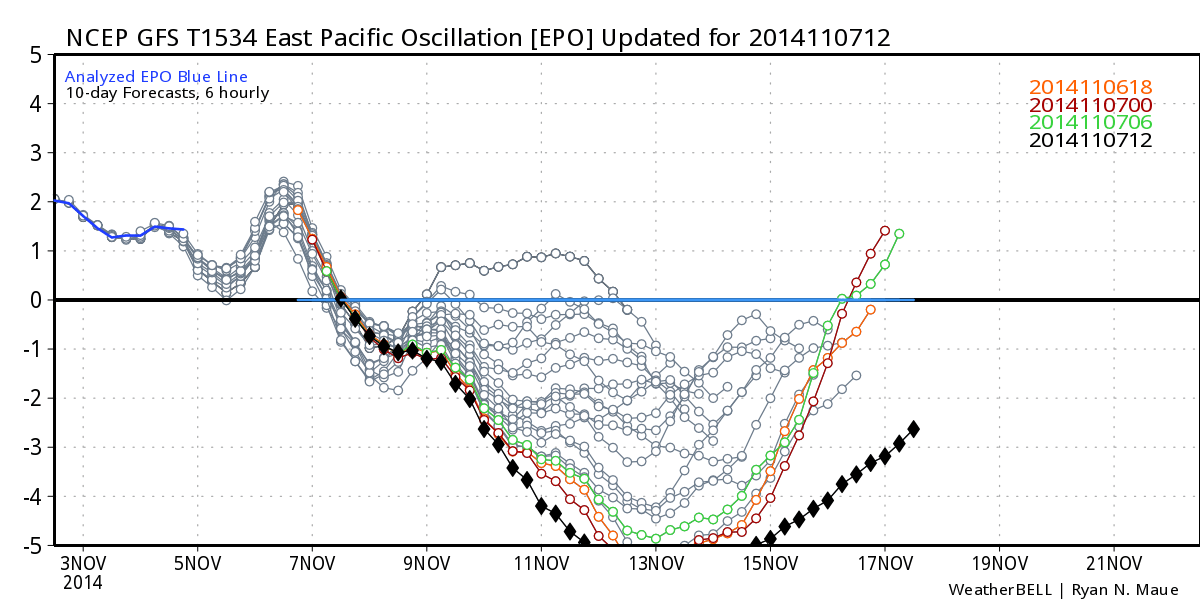 gfs has off the charts epo. this winter noaa is going to have to use bigger charts.
algae888- Advanced Forecaster

- Posts : 5311
Reputation : 46
Join date : 2013-02-05
Age : 61
Location : mt. vernon, new york
Re: Official Long Range Thread 4.0
![]() by algae888 Fri Nov 07, 2014 2:56 pm
by algae888 Fri Nov 07, 2014 2:56 pm
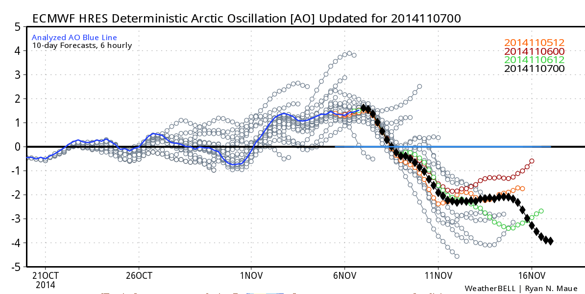
new charts for ao too! ao shows no signs of hitting bottom it just keeps falling.
algae888- Advanced Forecaster
- Posts : 5311
Reputation : 46
Join date : 2013-02-05
Age : 61
Location : mt. vernon, new york
Re: Official Long Range Thread 4.0
![]() by SoulSingMG Fri Nov 07, 2014 2:59 pm
by SoulSingMG Fri Nov 07, 2014 2:59 pm
Sunflowers138 wrote:Can someone post the snow map just for some giggles?
The map I referred to is the snow cover Euro one. But I'm on my iPhone and still can't figure out how to post images from it yet on here.
SoulSingMG- Senior Enthusiast
- Posts : 2853
Reputation : 74
Join date : 2013-12-11
Location : Long Island City, NY
Re: Official Long Range Thread 4.0
![]() by jmanley32 Fri Nov 07, 2014 2:59 pm
by jmanley32 Fri Nov 07, 2014 2:59 pm
jmanley32- Senior Enthusiast
- Posts : 20513
Reputation : 108
Join date : 2013-12-12
Age : 42
Location : Yonkers, NY
Re: Official Long Range Thread 4.0
![]() by algae888 Fri Nov 07, 2014 3:04 pm
by algae888 Fri Nov 07, 2014 3:04 pm
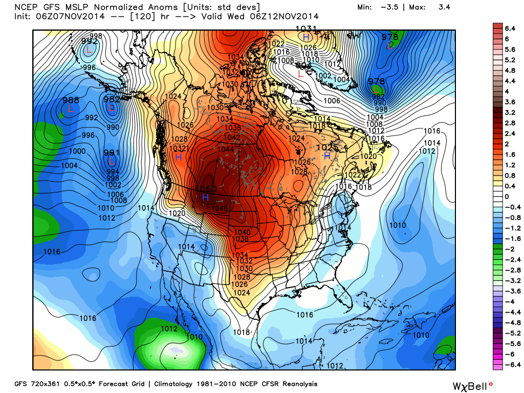
1050 mb HP coming into U.S. next week. WOW!
algae888- Advanced Forecaster
- Posts : 5311
Reputation : 46
Join date : 2013-02-05
Age : 61
Location : mt. vernon, new york
Re: Official Long Range Thread 4.0
![]() by Sunflowers138 Fri Nov 07, 2014 3:05 pm
by Sunflowers138 Fri Nov 07, 2014 3:05 pm
Sunflowers138- Posts : 76
Reputation : 0
Join date : 2013-01-14
Re: Official Long Range Thread 4.0
![]() by jmanley32 Fri Nov 07, 2014 3:07 pm
by jmanley32 Fri Nov 07, 2014 3:07 pm
jmanley32- Senior Enthusiast
- Posts : 20513
Reputation : 108
Join date : 2013-12-12
Age : 42
Location : Yonkers, NY
Re: Official Long Range Thread 4.0
![]() by Frank_Wx Fri Nov 07, 2014 3:15 pm
by Frank_Wx Fri Nov 07, 2014 3:15 pm
_________________
_______________________________________________________________________________________________________
CLICK HERE to view NJ Strong Snowstorm Classifications
Frank_Wx- Godzilla Seeker
- Posts : 21305
Reputation : 328
Join date : 2013-01-05
Age : 31
Location : Jersey City, NJ -
Re: Official Long Range Thread 4.0
![]() by amugs Fri Nov 07, 2014 3:21 pm
by amugs Fri Nov 07, 2014 3:21 pm
Frank_Wx wrote:If you remember I said this last year...extreme is not always good for us. A pattern that is too extreme, such as what we're seeing with the EPO these next 2 weeks, would result in storm tracks to our south since the PV would get too far south. It's not always the case, but the chance of it happening increases.
Oh yes and how we all cried from Feb 14th until March 22nd!!! Bone dry with a strong biag of a PV sitting just to our north!
_________________
Mugs
AKA:King: Snow Weenie
Self Proclaimed
WINTER 2014-15 : 55.12" +.02 for 6 coatings (avg. 35")
WINTER 2015-16 Total - 29.8" (Avg 35")
WINTER 2016-17 : 39.5" so far
amugs- Advanced Forecaster - Mod
- Posts : 15093
Reputation : 213
Join date : 2013-01-07
Age : 54
Location : Hillsdale,NJ
Re: Official Long Range Thread 4.0
![]() by SoulSingMG Fri Nov 07, 2014 3:23 pm
by SoulSingMG Fri Nov 07, 2014 3:23 pm
SoulSingMG- Senior Enthusiast
- Posts : 2853
Reputation : 74
Join date : 2013-12-11
Location : Long Island City, NY
Re: Official Long Range Thread 4.0
![]() by jmanley32 Fri Nov 07, 2014 3:24 pm
by jmanley32 Fri Nov 07, 2014 3:24 pm
jmanley32- Senior Enthusiast
- Posts : 20513
Reputation : 108
Join date : 2013-12-12
Age : 42
Location : Yonkers, NY
Re: Official Long Range Thread 4.0
![]() by jmanley32 Fri Nov 07, 2014 3:29 pm
by jmanley32 Fri Nov 07, 2014 3:29 pm
jmanley32- Senior Enthusiast
- Posts : 20513
Reputation : 108
Join date : 2013-12-12
Age : 42
Location : Yonkers, NY
Re: Official Long Range Thread 4.0
![]() by jmanley32 Fri Nov 07, 2014 3:35 pm
by jmanley32 Fri Nov 07, 2014 3:35 pm
jmanley32- Senior Enthusiast
- Posts : 20513
Reputation : 108
Join date : 2013-12-12
Age : 42
Location : Yonkers, NY
Re: Official Long Range Thread 4.0
![]() by Frank_Wx Fri Nov 07, 2014 3:46 pm
by Frank_Wx Fri Nov 07, 2014 3:46 pm

_________________
_______________________________________________________________________________________________________
CLICK HERE to view NJ Strong Snowstorm Classifications
Frank_Wx- Godzilla Seeker
- Posts : 21305
Reputation : 328
Join date : 2013-01-05
Age : 31
Location : Jersey City, NJ -
Re: Official Long Range Thread 4.0
![]() by jmanley32 Fri Nov 07, 2014 3:55 pm
by jmanley32 Fri Nov 07, 2014 3:55 pm
jmanley32- Senior Enthusiast
- Posts : 20513
Reputation : 108
Join date : 2013-12-12
Age : 42
Location : Yonkers, NY
Re: Official Long Range Thread 4.0
![]() by amugs Fri Nov 07, 2014 4:27 pm
by amugs Fri Nov 07, 2014 4:27 pm
Where is this from Soul or is this a troll to get the juices going??SoulSingMG wrote:@NWSWPC: 'THERE IS SOME MULTI-SOULTION SUPPORT FOR A WAVE OF SOME IMPORT THAT COULD COME FAR ENOUGH NORTHWARD ALONG THE EAST COAST TO PRODUCE SNOW IN THE EASTERN MID-ATLANTIC AND NEW ENGLAND DAY 7.'
_________________
Mugs
AKA:King: Snow Weenie
Self Proclaimed
WINTER 2014-15 : 55.12" +.02 for 6 coatings (avg. 35")
WINTER 2015-16 Total - 29.8" (Avg 35")
WINTER 2016-17 : 39.5" so far
amugs- Advanced Forecaster - Mod
- Posts : 15093
Reputation : 213
Join date : 2013-01-07
Age : 54
Location : Hillsdale,NJ
Page 8 of 42 • 1 ... 5 ... 7, 8, 9 ... 25 ... 42 ![]()
|
|
|