
 Search
Official Long Range Thread 4.0
Page 12 of 42 •  1 ... 7 ... 11, 12, 13 ... 27 ... 42
 ![]()
Re: Official Long Range Thread 4.0
![]() by amugs Sun Nov 09, 2014 4:12 pm
by amugs Sun Nov 09, 2014 4:12 pm

amugs- Advanced Forecaster - Mod

- Posts : 15093
Join date : 2013-01-07
Re: Official Long Range Thread 4.0
![]() by jmanley32 Sun Nov 09, 2014 5:17 pm
by jmanley32 Sun Nov 09, 2014 5:17 pm
jmanley32- Senior Enthusiast

- Posts : 20517
Join date : 2013-12-12
Re: Official Long Range Thread 4.0
![]() by Isotherm Sun Nov 09, 2014 6:26 pm
by Isotherm Sun Nov 09, 2014 6:26 pm
amugs wrote:Al and everyone else here - it will be one year ago Nov 12th that our first flakes flew for the area with that rapid cold front that swept in here - Mike pointed this out a bunch of posts back - the same type of pattern is incoming but the STJ (southern stream) is more active.
Mother Nature wants to give some flakes and a light sporadic dusting - I will take it - keep the eye on the second system IMO - the first one is going to set up a doozy. We have had three major anomaly storms since 2011 - SnowTober, Sandy and the Nor'easter that followed dumping good amount of snow over the region - this seem to be somewhat of a coincidence (? or pattern?) these past few years as we enter into the changing of the fall season within itself (not from fall to winter but early fall to latter fall). If this does occur then we will have seen a snowfall of accumulation for the past 3 out of four years in Oct and Nov - interesting.
Judan Cohen's thoughts on things - saying the SSW may happen sooner than we think - interesting and I said this as Scott pointed out those Kelvin Waves (moderate) coming east of the Indian Ocean area. Those like I have said and doen some research on can wreck havoc in the atmosphere for warming and convection.
Good read and only time will tell.
http://www.aer.com/science-research/climate-weather/arctic-oscillation
Mugs, I'm definitely of the opinion that there's a heightened probability for an earlier than normal SSW this year given the perturbation of the stratospheric vortex that has been ongoing for a few weeks already. The October pattern was very favorable for upward propagating Rossby waves, and the rapid snow cover advance has only enhanced the vertically propagating waves. We're doing serious damage to the vortex circulation and some of the longer term guidance suggests we could potentially see a vortex displacement or splitting event D10+. If this were to occur, say in late November or early December, it'd be the earliest SSW occurrence in quite awhile, and would probably ensure renewed blocking following the current episode. If we're devoid of any SSW through December, the current -NAO/AO episode will probably break down in mid December barring extremely favorable tropospheric forcing factors.
Very interesting year on our hands. Should be fun to watch this unfold. At this point, we're essentially guaranteed at least a 30-day period of blocking from the current -NAO/AO episode, which takes us through early December.
Isotherm- Advanced Forecaster

- Posts : 231
Reputation : 4
Join date : 2014-09-01
Age : 33
Location : Monmouth County, NJ -

Re: Official Long Range Thread 4.0
![]() by sroc4 Sun Nov 09, 2014 9:01 pm
by sroc4 Sun Nov 09, 2014 9:01 pm
_________________
"In weather and in life, there's no winning and losing; there's only winning and learning."
WINTER 2012/2013 TOTALS 43.65"WINTER 2017/2018 TOTALS 62.85" WINTER 2022/2023 TOTALS 4.9"
WINTER 2013/2014 TOTALS 64.85"WINTER 2018/2019 TOTALS 14.25" WINTER 2023/2024 TOTALS 13.1"
WINTER 2014/2015 TOTALS 71.20"WINTER 2019/2020 TOTALS 6.35"
WINTER 2015/2016 TOTALS 35.00"WINTER 2020/2021 TOTALS 37.75"
WINTER 2016/2017 TOTALS 42.25"WINTER 2021/2022 TOTALS 31.65"

sroc4- Admin

- Posts : 8331
Reputation : 301
Join date : 2013-01-07
Location : Wading River, LI
Re: Official Long Range Thread 4.0
![]() by Frank_Wx Sun Nov 09, 2014 9:28 pm
by Frank_Wx Sun Nov 09, 2014 9:28 pm
sroc4 wrote:I guess this is long range. The British building a new supercomputer for forecasting. Set to finish in 2017. http://www.extremetech.com/extreme/193054-defying-drizzle-uk-to-build-worlds-fastest-weather-forecasting-supercomputer
Madonne, that is fast.
_________________
_______________________________________________________________________________________________________
CLICK HERE to view NJ Strong Snowstorm Classifications

Frank_Wx- Godzilla Seeker
- Posts : 21305
Reputation : 328
Join date : 2013-01-05
Age : 31
Location : Jersey City, NJ -
Re: Official Long Range Thread 4.0
![]() by NjWeatherGuy Sun Nov 09, 2014 9:42 pm
by NjWeatherGuy Sun Nov 09, 2014 9:42 pm

NjWeatherGuy- Advanced Forecaster
- Posts : 4100
Reputation : 28
Join date : 2013-01-06
Location : Belle Mead, NJ
Re: Official Long Range Thread 4.0
![]() by sroc4 Sun Nov 09, 2014 9:42 pm
by sroc4 Sun Nov 09, 2014 9:42 pm
Frank_Wx wrote:sroc4 wrote:I guess this is long range. The British building a new supercomputer for forecasting. Set to finish in 2017. http://www.extremetech.com/extreme/193054-defying-drizzle-uk-to-build-worlds-fastest-weather-forecasting-supercomputer
Madonne, that is fast.
Your not kidding. 16 quadrillion calculations per second. My head hurts thinking about it.
_________________
"In weather and in life, there's no winning and losing; there's only winning and learning."
WINTER 2012/2013 TOTALS 43.65"WINTER 2017/2018 TOTALS 62.85" WINTER 2022/2023 TOTALS 4.9"
WINTER 2013/2014 TOTALS 64.85"WINTER 2018/2019 TOTALS 14.25" WINTER 2023/2024 TOTALS 13.1"
WINTER 2014/2015 TOTALS 71.20"WINTER 2019/2020 TOTALS 6.35"
WINTER 2015/2016 TOTALS 35.00"WINTER 2020/2021 TOTALS 37.75"
WINTER 2016/2017 TOTALS 42.25"WINTER 2021/2022 TOTALS 31.65"
sroc4- Admin
- Posts : 8331
Reputation : 301
Join date : 2013-01-07
Location : Wading River, LI
Re: Official Long Range Thread 4.0
![]() by Frank_Wx Sun Nov 09, 2014 10:09 pm
by Frank_Wx Sun Nov 09, 2014 10:09 pm
NjWeatherGuy wrote:This is beginning to peak my interest
Which event? I kind of like Friday for our first flakes. I like the second event for areas west of I-95 for their first accumulating snow. Obviously this could trend colder, and with the cold air being modeled, it would not shock me. The blocking certainly is there
_________________
_______________________________________________________________________________________________________
CLICK HERE to view NJ Strong Snowstorm Classifications
Frank_Wx- Godzilla Seeker
- Posts : 21305
Reputation : 328
Join date : 2013-01-05
Age : 31
Location : Jersey City, NJ -
Re: Official Long Range Thread 4.0
![]() by amugs Sun Nov 09, 2014 10:11 pm
by amugs Sun Nov 09, 2014 10:11 pm
Tom, great post and I said this before that these waves occurring high in the atmosphere are not picked up nor I believe calculated into the models until the resultant has occurred - SSW or the early warming stages of such. The snow cover is immense and interestingly enough we have only been tracking this for Siberia since 1997? A lot happening with this changing pattern and very exciting - as I peer into my Snow Weenie snowball I foresee many a storm possibility on the near and winter season horizon - with lots of discussion and threads upon threads and posts. Fun times are awaiting.
It would be a kick in the arse if we had to use a snow day before turkey day - could happen. Next two days give us greater insight into what the first wave will be at the end of the week.
_________________
Mugs
AKA:King: Snow Weenie
Self Proclaimed
WINTER 2014-15 : 55.12" +.02 for 6 coatings (avg. 35")
WINTER 2015-16 Total - 29.8" (Avg 35")
WINTER 2016-17 : 39.5" so far

amugs- Advanced Forecaster - Mod
- Posts : 15093
Reputation : 213
Join date : 2013-01-07
Age : 54
Location : Hillsdale,NJ
Re: Official Long Range Thread 4.0
![]() by NjWeatherGuy Sun Nov 09, 2014 10:35 pm
by NjWeatherGuy Sun Nov 09, 2014 10:35 pm
Frank_Wx wrote:NjWeatherGuy wrote:This is beginning to peak my interest
Which event? I kind of like Friday for our first flakes. I like the second event for areas west of I-95 for their first accumulating snow. Obviously this could trend colder, and with the cold air being modeled, it would not shock me. The blocking certainly is there
I see both having potential, not too confident about the first one just yet because ive seen some dry and sliding looking runs with very little QPF if any. Really like the pattern that follows to potentially get the ball rolling early on the winter storm season.
NjWeatherGuy- Advanced Forecaster
- Posts : 4100
Reputation : 28
Join date : 2013-01-06
Location : Belle Mead, NJ
Re: Official Long Range Thread 4.0
![]() by Frank_Wx Sun Nov 09, 2014 10:58 pm
by Frank_Wx Sun Nov 09, 2014 10:58 pm
_________________
_______________________________________________________________________________________________________
CLICK HERE to view NJ Strong Snowstorm Classifications
Frank_Wx- Godzilla Seeker
- Posts : 21305
Reputation : 328
Join date : 2013-01-05
Age : 31
Location : Jersey City, NJ -
Re: Official Long Range Thread 4.0
![]() by Frank_Wx Sun Nov 09, 2014 11:20 pm
by Frank_Wx Sun Nov 09, 2014 11:20 pm
_________________
_______________________________________________________________________________________________________
CLICK HERE to view NJ Strong Snowstorm Classifications
Frank_Wx- Godzilla Seeker
- Posts : 21305
Reputation : 328
Join date : 2013-01-05
Age : 31
Location : Jersey City, NJ -
Re: Official Long Range Thread 4.0
![]() by Frank_Wx Sun Nov 09, 2014 11:22 pm
by Frank_Wx Sun Nov 09, 2014 11:22 pm


Done by hour 177
_________________
_______________________________________________________________________________________________________
CLICK HERE to view NJ Strong Snowstorm Classifications
Frank_Wx- Godzilla Seeker
- Posts : 21305
Reputation : 328
Join date : 2013-01-05
Age : 31
Location : Jersey City, NJ -

Vinnydula- Pro Enthusiast

- Posts : 778
Reputation : 8
Join date : 2013-12-12
Location : Dobbs ferry
Re: Official Long Range Thread 4.0
![]() by aiannone Sun Nov 09, 2014 11:31 pm
by aiannone Sun Nov 09, 2014 11:31 pm
_________________
-Alex Iannone-

aiannone- Senior Enthusiast - Mod
- Posts : 4814
Reputation : 92
Join date : 2013-01-07
Location : Saint James, LI (Northwest Suffolk Co.)
Re: Official Long Range Thread 4.0
![]() by Frank_Wx Sun Nov 09, 2014 11:32 pm
by Frank_Wx Sun Nov 09, 2014 11:32 pm
Vinnydula wrote:Would that be snow
No, but it could start as snow or end as snow. It would be snow in NW NJ and NEPA, in SNOWMAN's territory.
_________________
_______________________________________________________________________________________________________
CLICK HERE to view NJ Strong Snowstorm Classifications
Frank_Wx- Godzilla Seeker
- Posts : 21305
Reputation : 328
Join date : 2013-01-05
Age : 31
Location : Jersey City, NJ -
Re: Official Long Range Thread 4.0
![]() by algae888 Sun Nov 09, 2014 11:38 pm
by algae888 Sun Nov 09, 2014 11:38 pm


algae888- Advanced Forecaster
- Posts : 5311
Reputation : 46
Join date : 2013-02-05
Age : 61
Location : mt. vernon, new york
Re: Official Long Range Thread 4.0
![]() by Frank_Wx Sun Nov 09, 2014 11:42 pm
by Frank_Wx Sun Nov 09, 2014 11:42 pm
algae888 wrote:frank precip still around at hr 180. still a long way to go with this one.
Do not think that is right, SV shows nothing at 180 hours?
_________________
_______________________________________________________________________________________________________
CLICK HERE to view NJ Strong Snowstorm Classifications
Frank_Wx- Godzilla Seeker
- Posts : 21305
Reputation : 328
Join date : 2013-01-05
Age : 31
Location : Jersey City, NJ -
Re: Official Long Range Thread 4.0
![]() by Frank_Wx Sun Nov 09, 2014 11:43 pm
by Frank_Wx Sun Nov 09, 2014 11:43 pm
_________________
_______________________________________________________________________________________________________
CLICK HERE to view NJ Strong Snowstorm Classifications
Frank_Wx- Godzilla Seeker
- Posts : 21305
Reputation : 328
Join date : 2013-01-05
Age : 31
Location : Jersey City, NJ -
Re: Official Long Range Thread 4.0
![]() by algae888 Sun Nov 09, 2014 11:46 pm
by algae888 Sun Nov 09, 2014 11:46 pm
algae888- Advanced Forecaster
- Posts : 5311
Reputation : 46
Join date : 2013-02-05
Age : 61
Location : mt. vernon, new york
Re: Official Long Range Thread 4.0
![]() by sroc4 Mon Nov 10, 2014 6:41 am
by sroc4 Mon Nov 10, 2014 6:41 am
_________________
"In weather and in life, there's no winning and losing; there's only winning and learning."
WINTER 2012/2013 TOTALS 43.65"WINTER 2017/2018 TOTALS 62.85" WINTER 2022/2023 TOTALS 4.9"
WINTER 2013/2014 TOTALS 64.85"WINTER 2018/2019 TOTALS 14.25" WINTER 2023/2024 TOTALS 13.1"
WINTER 2014/2015 TOTALS 71.20"WINTER 2019/2020 TOTALS 6.35"
WINTER 2015/2016 TOTALS 35.00"WINTER 2020/2021 TOTALS 37.75"
WINTER 2016/2017 TOTALS 42.25"WINTER 2021/2022 TOTALS 31.65"
sroc4- Admin
- Posts : 8331
Reputation : 301
Join date : 2013-01-07
Location : Wading River, LI
Re: Official Long Range Thread 4.0
![]() by jmanley32 Mon Nov 10, 2014 7:01 am
by jmanley32 Mon Nov 10, 2014 7:01 am

jmanley32- Senior Enthusiast
- Posts : 20517
Reputation : 108
Join date : 2013-12-12
Age : 42
Location : Yonkers, NY
Re: Official Long Range Thread 4.0
![]() by sroc4 Mon Nov 10, 2014 8:13 am
by sroc4 Mon Nov 10, 2014 8:13 am
Yesterday 00z:
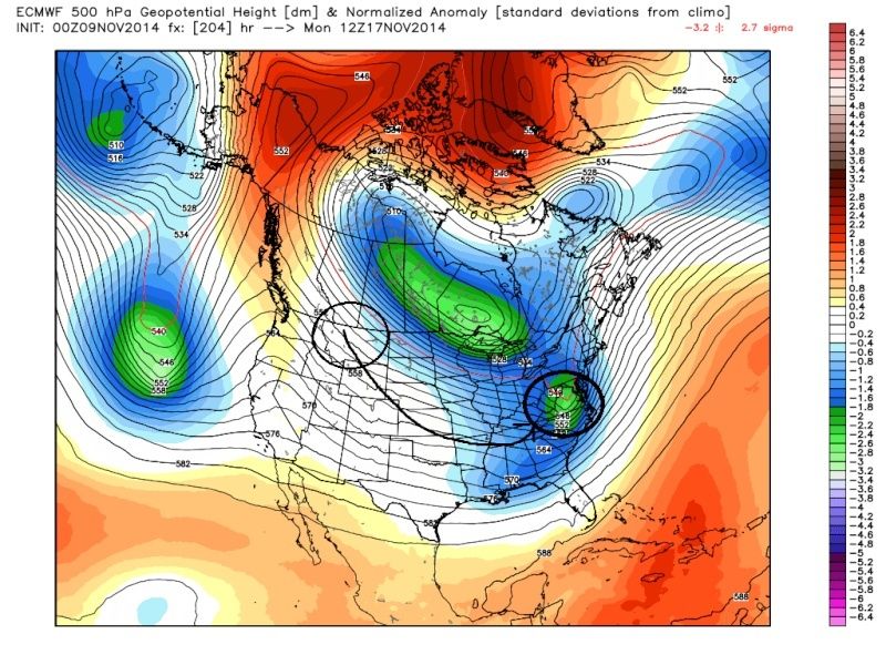 " />
" />Today's 00z
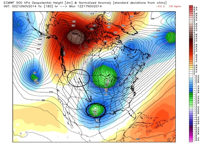 " />
" />Last edited by sroc4 on Mon Nov 10, 2014 8:27 am; edited 1 time in total
_________________
"In weather and in life, there's no winning and losing; there's only winning and learning."
WINTER 2012/2013 TOTALS 43.65"WINTER 2017/2018 TOTALS 62.85" WINTER 2022/2023 TOTALS 4.9"
WINTER 2013/2014 TOTALS 64.85"WINTER 2018/2019 TOTALS 14.25" WINTER 2023/2024 TOTALS 13.1"
WINTER 2014/2015 TOTALS 71.20"WINTER 2019/2020 TOTALS 6.35"
WINTER 2015/2016 TOTALS 35.00"WINTER 2020/2021 TOTALS 37.75"
WINTER 2016/2017 TOTALS 42.25"WINTER 2021/2022 TOTALS 31.65"
sroc4- Admin
- Posts : 8331
Reputation : 301
Join date : 2013-01-07
Location : Wading River, LI
Re: Official Long Range Thread 4.0
![]() by skinsfan1177 Mon Nov 10, 2014 8:17 am
by skinsfan1177 Mon Nov 10, 2014 8:17 am

skinsfan1177- Senior Enthusiast
- Posts : 4485
Reputation : 35
Join date : 2013-01-07
Age : 46
Location : Point Pleasant Boro
Re: Official Long Range Thread 4.0
![]() by sroc4 Mon Nov 10, 2014 8:30 am
by sroc4 Mon Nov 10, 2014 8:30 am
skinsfan1177 wrote:Need to get thru the first system before examining the second
Take a look at my prev post I edited it. I was actually realizing that as you were posting. I said it yesterday and still believe it today I think the first system will have minor impacts if any, and the second one is the one to watch, but your absolutely right.
_________________
"In weather and in life, there's no winning and losing; there's only winning and learning."
WINTER 2012/2013 TOTALS 43.65"WINTER 2017/2018 TOTALS 62.85" WINTER 2022/2023 TOTALS 4.9"
WINTER 2013/2014 TOTALS 64.85"WINTER 2018/2019 TOTALS 14.25" WINTER 2023/2024 TOTALS 13.1"
WINTER 2014/2015 TOTALS 71.20"WINTER 2019/2020 TOTALS 6.35"
WINTER 2015/2016 TOTALS 35.00"WINTER 2020/2021 TOTALS 37.75"
WINTER 2016/2017 TOTALS 42.25"WINTER 2021/2022 TOTALS 31.65"
sroc4- Admin
- Posts : 8331
Reputation : 301
Join date : 2013-01-07
Location : Wading River, LI
Re: Official Long Range Thread 4.0
![]() by jmanley32 Mon Nov 10, 2014 10:01 am
by jmanley32 Mon Nov 10, 2014 10:01 am
jmanley32- Senior Enthusiast
- Posts : 20517
Reputation : 108
Join date : 2013-12-12
Age : 42
Location : Yonkers, NY
Re: Official Long Range Thread 4.0
![]() by Frank_Wx Mon Nov 10, 2014 11:20 am
by Frank_Wx Mon Nov 10, 2014 11:20 am
By the way, 12z GFS is a miss for Friday. EURO has snow showers still.
_________________
_______________________________________________________________________________________________________
CLICK HERE to view NJ Strong Snowstorm Classifications
Frank_Wx- Godzilla Seeker
- Posts : 21305
Reputation : 328
Join date : 2013-01-05
Age : 31
Location : Jersey City, NJ -
Page 12 of 42 • 1 ... 7 ... 11, 12, 13 ... 27 ... 42 ![]()
|
|
|