
 Search
Official Long Range Thread 4.0
Page 24 of 42 •  1 ... 13 ... 23, 24, 25 ... 33 ... 42
 ![]()
Re: Official Long Range Thread 4.0
![]() by sroc4 Thu Nov 27, 2014 8:20 am
by sroc4 Thu Nov 27, 2014 8:20 am
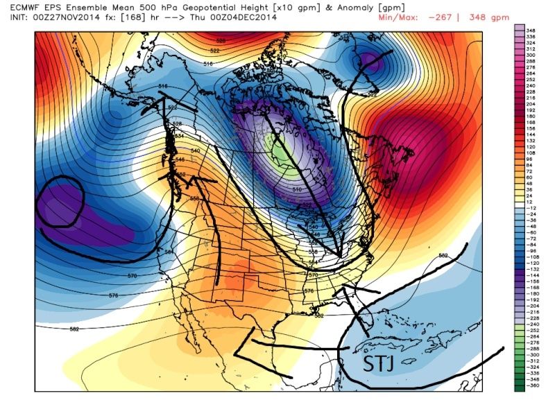
 " />
" />From this look it looks like there is a ridge from the SW CONUS extending east involving the southern half of the CONUS extending into the NE. We should be above normal temps with a zonal flow in the east with this look. How is that conducive for a storm? If you correct for some of the known bias' in the European model if you pull the trough back that is off the west coast just a little bit it should act to pump the ridge along the west coast instead of cut it off like its showing. As a result if you eliminated the connection between the trough in the pacific with the vortex over Canada, that trough should in theory promote ridging in the west and in turn a digging trough into the plains and eventually into the NE. In theory the STJ (sub tropical jet) would shift back west as well and maybe there is some interaction with the northern jet (because its allowed to dig a bit deeper into the central CONUS) and possibly interact with the STJ to look more like this:
 " />
" />I may not be crazy because the Euro Ensemble mean at the same time frame is trying to hint at this. Look at this:
 " />
" />Im just throwing this out there. It may not come to fruition but as Al pointed out the AO wants to go neg and the PNA wants to go positive right around this time frame.
sroc4- Admin

- Posts : 8331
Join date : 2013-01-07
Re: Official Long Range Thread 4.0
![]() by amugs Thu Nov 27, 2014 12:08 pm
by amugs Thu Nov 27, 2014 12:08 pm
Have a great Thanksgiving.
amugs- Advanced Forecaster - Mod

- Posts : 15093
Join date : 2013-01-07
Re: Official Long Range Thread 4.0
![]() by jmanley32 Thu Nov 27, 2014 4:59 pm
by jmanley32 Thu Nov 27, 2014 4:59 pm

jmanley32- Senior Enthusiast

- Posts : 20512
Reputation : 108
Join date : 2013-12-12
Age : 42
Location : Yonkers, NY
Re: Official Long Range Thread 4.0
![]() by NjWeatherGuy Thu Nov 27, 2014 9:50 pm
by NjWeatherGuy Thu Nov 27, 2014 9:50 pm

NjWeatherGuy- Advanced Forecaster

- Posts : 4100
Reputation : 28
Join date : 2013-01-06
Location : Belle Mead, NJ
Re: Official Long Range Thread 4.0
![]() by Snow88 Fri Nov 28, 2014 12:07 am
by Snow88 Fri Nov 28, 2014 12:07 am

Snow88- Senior Enthusiast
- Posts : 2193
Reputation : 4
Join date : 2013-01-09
Age : 35
Location : Brooklyn, NY
Re: Official Long Range Thread 4.0
![]() by sroc4 Fri Nov 28, 2014 7:03 am
by sroc4 Fri Nov 28, 2014 7:03 am
" />And this is last nights 00z Euro same time frame. As you can see big changes to the upper levels from one run to the next. Notice the ridge trying to get its act together now in the west and a neg tilted trough in the east. If the blues and purples were a bit more consolidated out in the Pac this could get interesting.

Coming around to my idea, but as of now it's merely a small threat. Nothing imminent. Models will flip and flop like crazy in the long range while pattern is undergoing changes. FWIW CMC is similar to this at H5 for Dec 4th;whereas, the GFS and PGFS look nothing like this.
_________________
"In weather and in life, there's no winning and losing; there's only winning and learning."
WINTER 2012/2013 TOTALS 43.65"WINTER 2017/2018 TOTALS 62.85" WINTER 2022/2023 TOTALS 4.9"
WINTER 2013/2014 TOTALS 64.85"WINTER 2018/2019 TOTALS 14.25" WINTER 2023/2024 TOTALS 13.1"
WINTER 2014/2015 TOTALS 71.20"WINTER 2019/2020 TOTALS 6.35"
WINTER 2015/2016 TOTALS 35.00"WINTER 2020/2021 TOTALS 37.75"
WINTER 2016/2017 TOTALS 42.25"WINTER 2021/2022 TOTALS 31.65"

sroc4- Admin
- Posts : 8331
Reputation : 301
Join date : 2013-01-07
Location : Wading River, LI
Re: Official Long Range Thread 4.0
![]() by skinsfan1177 Fri Nov 28, 2014 8:22 am
by skinsfan1177 Fri Nov 28, 2014 8:22 am

skinsfan1177- Senior Enthusiast
- Posts : 4485
Reputation : 35
Join date : 2013-01-07
Age : 46
Location : Point Pleasant Boro
Re: Official Long Range Thread 4.0
![]() by algae888 Fri Nov 28, 2014 9:48 am
by algae888 Fri Nov 28, 2014 9:48 am
skinsfan1177 wrote:I hope this winter comes to fruitation with all the info I have got from this board I have been telling people this winter is going to be epic lol or as we see it has the potential to be.
skins as you know any thing can happen with the weather however look at the pattern we have been in the last 2+ weeks. more like jan than nov. plus the next 10-14 days we will be near to slightly below normal with a pattern that has relaxed and is more zonal which is a very good sign IMO. there are no big warm ups in sight. maybe a day or two above and then right back to below . after that everything is pointing towards a more amplified one with cold out breaks and increasing chances for snow. and remember all this is happening pre winter we still have 23 more days until winter officially starts

algae888- Advanced Forecaster
- Posts : 5311
Reputation : 46
Join date : 2013-02-05
Age : 61
Location : mt. vernon, new york
Re: Official Long Range Thread 4.0
![]() by Frank_Wx Fri Nov 28, 2014 9:55 am
by Frank_Wx Fri Nov 28, 2014 9:55 am

_________________
_______________________________________________________________________________________________________
CLICK HERE to view NJ Strong Snowstorm Classifications

Frank_Wx- Godzilla Seeker
- Posts : 21305
Reputation : 328
Join date : 2013-01-05
Age : 31
Location : Jersey City, NJ -

Re: Official Long Range Thread 4.0
![]() by Snow88 Fri Nov 28, 2014 10:11 am
by Snow88 Fri Nov 28, 2014 10:11 am
http://www.cpc.ncep.noaa.gov/products/precip/CWlink/pna/pna.sprd2.gif
http://www.cpc.ncep.noaa.gov/products/precip/CWlink/pna/nao.shtml
Snow88- Senior Enthusiast
- Posts : 2193
Reputation : 4
Join date : 2013-01-09
Age : 35
Location : Brooklyn, NY
Re: Official Long Range Thread 4.0
![]() by Frank_Wx Fri Nov 28, 2014 2:52 pm
by Frank_Wx Fri Nov 28, 2014 2:52 pm

_________________
_______________________________________________________________________________________________________
CLICK HERE to view NJ Strong Snowstorm Classifications
Frank_Wx- Godzilla Seeker
- Posts : 21305
Reputation : 328
Join date : 2013-01-05
Age : 31
Location : Jersey City, NJ -
Re: Official Long Range Thread 4.0
![]() by nutleyblizzard Fri Nov 28, 2014 3:05 pm
by nutleyblizzard Fri Nov 28, 2014 3:05 pm
Everybody get your rest now, the next couple of weeks look rather uneventful. By the time we get to mid December this weather forum WILL BE ROCKING!!!Frank_Wx wrote:


nutleyblizzard- Senior Enthusiast
- Posts : 1952
Reputation : 41
Join date : 2014-01-30
Age : 58
Location : Nutley, new jersey
Re: Official Long Range Thread 4.0
![]() by CPcantmeasuresnow Fri Nov 28, 2014 9:56 pm
by CPcantmeasuresnow Fri Nov 28, 2014 9:56 pm
The snowfall of 0.2 inches will be below the 30 year average of 0.3 and the 145 year average of 0.8.
Of course other areas of the Metro, Orange County for one where we've had about a foot this month, will end up above normal regarding snowfall.

CPcantmeasuresnow- Wx Statistician Guru

- Posts : 7274
Reputation : 230
Join date : 2013-01-07
Age : 103
Location : Eastern Orange County, NY
Re: Official Long Range Thread 4.0
![]() by Snow88 Sat Nov 29, 2014 12:27 pm
by Snow88 Sat Nov 29, 2014 12:27 pm
Snow88- Senior Enthusiast
- Posts : 2193
Reputation : 4
Join date : 2013-01-09
Age : 35
Location : Brooklyn, NY
Re: Official Long Range Thread 4.0
![]() by Frank_Wx Sat Nov 29, 2014 1:20 pm
by Frank_Wx Sat Nov 29, 2014 1:20 pm
_________________
_______________________________________________________________________________________________________
CLICK HERE to view NJ Strong Snowstorm Classifications
Frank_Wx- Godzilla Seeker
- Posts : 21305
Reputation : 328
Join date : 2013-01-05
Age : 31
Location : Jersey City, NJ -
Re: Official Long Range Thread 4.0
![]() by jmanley32 Sat Nov 29, 2014 5:42 pm
by jmanley32 Sat Nov 29, 2014 5:42 pm
jmanley32- Senior Enthusiast
- Posts : 20512
Reputation : 108
Join date : 2013-12-12
Age : 42
Location : Yonkers, NY
Re: Official Long Range Thread 4.0
![]() by sroc4 Sat Nov 29, 2014 6:25 pm
by sroc4 Sat Nov 29, 2014 6:25 pm
_________________
"In weather and in life, there's no winning and losing; there's only winning and learning."
WINTER 2012/2013 TOTALS 43.65"WINTER 2017/2018 TOTALS 62.85" WINTER 2022/2023 TOTALS 4.9"
WINTER 2013/2014 TOTALS 64.85"WINTER 2018/2019 TOTALS 14.25" WINTER 2023/2024 TOTALS 13.1"
WINTER 2014/2015 TOTALS 71.20"WINTER 2019/2020 TOTALS 6.35"
WINTER 2015/2016 TOTALS 35.00"WINTER 2020/2021 TOTALS 37.75"
WINTER 2016/2017 TOTALS 42.25"WINTER 2021/2022 TOTALS 31.65"
sroc4- Admin
- Posts : 8331
Reputation : 301
Join date : 2013-01-07
Location : Wading River, LI
Re: Official Long Range Thread 4.0
![]() by jmanley32 Sat Nov 29, 2014 7:18 pm
by jmanley32 Sat Nov 29, 2014 7:18 pm
jmanley32- Senior Enthusiast
- Posts : 20512
Reputation : 108
Join date : 2013-12-12
Age : 42
Location : Yonkers, NY
Re: Official Long Range Thread 4.0
![]() by Frank_Wx Sat Nov 29, 2014 8:04 pm
by Frank_Wx Sat Nov 29, 2014 8:04 pm
_________________
_______________________________________________________________________________________________________
CLICK HERE to view NJ Strong Snowstorm Classifications
Frank_Wx- Godzilla Seeker
- Posts : 21305
Reputation : 328
Join date : 2013-01-05
Age : 31
Location : Jersey City, NJ -
Re: Official Long Range Thread 4.0
![]() by sroc4 Sun Nov 30, 2014 8:20 am
by sroc4 Sun Nov 30, 2014 8:20 am
Frank_Wx wrote:Judah Cohen, the man who discovered the SAI correlation with winter patterns, is concerned about an anomalous polar low that developed in Northwest Asia and how it could disrupt the expansion of the Siberian High, which is critical for us to get our AO negative. He says some models bring that polar low back to its climatological spot, but others are still displacing it in an unusual spot. Interesting...let's hope that's not bad news.
Interesting Frank. Do you have a link to read about this? We will also have to see if the forecasted typhoon in the SW PAC in the LR actually develops and recurves. If it does it could be what locks us in for late Dec into early Jan.
_________________
"In weather and in life, there's no winning and losing; there's only winning and learning."
WINTER 2012/2013 TOTALS 43.65"WINTER 2017/2018 TOTALS 62.85" WINTER 2022/2023 TOTALS 4.9"
WINTER 2013/2014 TOTALS 64.85"WINTER 2018/2019 TOTALS 14.25" WINTER 2023/2024 TOTALS 13.1"
WINTER 2014/2015 TOTALS 71.20"WINTER 2019/2020 TOTALS 6.35"
WINTER 2015/2016 TOTALS 35.00"WINTER 2020/2021 TOTALS 37.75"
WINTER 2016/2017 TOTALS 42.25"WINTER 2021/2022 TOTALS 31.65"
sroc4- Admin
- Posts : 8331
Reputation : 301
Join date : 2013-01-07
Location : Wading River, LI
Re: Official Long Range Thread 4.0
![]() by sroc4 Sun Nov 30, 2014 8:28 am
by sroc4 Sun Nov 30, 2014 8:28 am
_________________
"In weather and in life, there's no winning and losing; there's only winning and learning."
WINTER 2012/2013 TOTALS 43.65"WINTER 2017/2018 TOTALS 62.85" WINTER 2022/2023 TOTALS 4.9"
WINTER 2013/2014 TOTALS 64.85"WINTER 2018/2019 TOTALS 14.25" WINTER 2023/2024 TOTALS 13.1"
WINTER 2014/2015 TOTALS 71.20"WINTER 2019/2020 TOTALS 6.35"
WINTER 2015/2016 TOTALS 35.00"WINTER 2020/2021 TOTALS 37.75"
WINTER 2016/2017 TOTALS 42.25"WINTER 2021/2022 TOTALS 31.65"
sroc4- Admin
- Posts : 8331
Reputation : 301
Join date : 2013-01-07
Location : Wading River, LI
Re: Official Long Range Thread 4.0
![]() by Snow88 Sun Nov 30, 2014 11:52 am
by Snow88 Sun Nov 30, 2014 11:52 am
PNA is still forecasted to rise
http://www.cpc.ncep.noaa.gov/products/precip/CWlink/pna/pna.shtml
AO looks like it will fall into the negative category with some members in the positive category
http://www.cpc.ncep.noaa.gov/products/precip/CWlink/daily_ao_index/ao.sprd2.gif
NAO has mixed signals
http://www.cpc.ncep.noaa.gov/products/precip/CWlink/pna/nao.sprd2.gif
Snow88- Senior Enthusiast
- Posts : 2193
Reputation : 4
Join date : 2013-01-09
Age : 35
Location : Brooklyn, NY
Re: Official Long Range Thread 4.0
![]() by Frank_Wx Sun Nov 30, 2014 12:20 pm
by Frank_Wx Sun Nov 30, 2014 12:20 pm
http://www.vwkweb.nl/index.php?page=537&sl=1
_________________
_______________________________________________________________________________________________________
CLICK HERE to view NJ Strong Snowstorm Classifications
Frank_Wx- Godzilla Seeker
- Posts : 21305
Reputation : 328
Join date : 2013-01-05
Age : 31
Location : Jersey City, NJ -
Re: Official Long Range Thread 4.0
![]() by Frank_Wx Sun Nov 30, 2014 12:21 pm
by Frank_Wx Sun Nov 30, 2014 12:21 pm
_________________
_______________________________________________________________________________________________________
CLICK HERE to view NJ Strong Snowstorm Classifications
Frank_Wx- Godzilla Seeker
- Posts : 21305
Reputation : 328
Join date : 2013-01-05
Age : 31
Location : Jersey City, NJ -
Re: Official Long Range Thread 4.0
![]() by algae888 Sun Nov 30, 2014 12:40 pm
by algae888 Sun Nov 30, 2014 12:40 pm
algae888- Advanced Forecaster
- Posts : 5311
Reputation : 46
Join date : 2013-02-05
Age : 61
Location : mt. vernon, new york
Re: Official Long Range Thread 4.0
![]() by Frank_Wx Sun Nov 30, 2014 12:56 pm
by Frank_Wx Sun Nov 30, 2014 12:56 pm
algae888 wrote:frank read parts of the article and wanted to know what has become of that polar low? it is 16 days since article was written.. do you have any idea?
It is there, but the models boot it out by next week. There will probably be a lull in the SSW progression then it will resume again.
_________________
_______________________________________________________________________________________________________
CLICK HERE to view NJ Strong Snowstorm Classifications
Frank_Wx- Godzilla Seeker
- Posts : 21305
Reputation : 328
Join date : 2013-01-05
Age : 31
Location : Jersey City, NJ -
Re: Official Long Range Thread 4.0
![]() by sroc4 Sun Nov 30, 2014 3:14 pm
by sroc4 Sun Nov 30, 2014 3:14 pm
Frank_Wx wrote:Here you go Doc
http://www.vwkweb.nl/index.php?page=537&sl=1
Thanks Frank. I'll have to read it after football. Go Giants! go Pack!
_________________
"In weather and in life, there's no winning and losing; there's only winning and learning."
WINTER 2012/2013 TOTALS 43.65"WINTER 2017/2018 TOTALS 62.85" WINTER 2022/2023 TOTALS 4.9"
WINTER 2013/2014 TOTALS 64.85"WINTER 2018/2019 TOTALS 14.25" WINTER 2023/2024 TOTALS 13.1"
WINTER 2014/2015 TOTALS 71.20"WINTER 2019/2020 TOTALS 6.35"
WINTER 2015/2016 TOTALS 35.00"WINTER 2020/2021 TOTALS 37.75"
WINTER 2016/2017 TOTALS 42.25"WINTER 2021/2022 TOTALS 31.65"
sroc4- Admin
- Posts : 8331
Reputation : 301
Join date : 2013-01-07
Location : Wading River, LI
Page 24 of 42 • 1 ... 13 ... 23, 24, 25 ... 33 ... 42 ![]()
|
|
|