
 Search
11/26 Strong Coastal Storm Possible
Page 17 of 23 •  1 ... 10 ... 16, 17, 18 ... 23
 ![]()
Re: 11/26 Strong Coastal Storm Possible
![]() by Frank_Wx Mon Nov 24, 2014 1:09 am
by Frank_Wx Mon Nov 24, 2014 1:09 am
Frank_Wx- Godzilla Seeker

- Posts : 21305
Join date : 2013-01-05 -

Re: 11/26 Strong Coastal Storm Possible
![]() by Frank_Wx Mon Nov 24, 2014 1:11 am
by Frank_Wx Mon Nov 24, 2014 1:11 am
Frank_Wx- Godzilla Seeker
- Posts : 21305
Join date : 2013-01-05 -
Re: 11/26 Strong Coastal Storm Possible
![]() by SoulSingMG Mon Nov 24, 2014 1:11 am
by SoulSingMG Mon Nov 24, 2014 1:11 am

SoulSingMG- Senior Enthusiast

- Posts : 2853
Reputation : 74
Join date : 2013-12-11
Location : Long Island City, NY

Vinnydula- Pro Enthusiast

- Posts : 778
Reputation : 8
Join date : 2013-12-12
Location : Dobbs ferry
Re: 11/26 Strong Coastal Storm Possible
![]() by Frank_Wx Mon Nov 24, 2014 1:13 am
by Frank_Wx Mon Nov 24, 2014 1:13 am


_________________
_______________________________________________________________________________________________________
CLICK HERE to view NJ Strong Snowstorm Classifications

Frank_Wx- Godzilla Seeker
- Posts : 21305
Reputation : 328
Join date : 2013-01-05
Age : 31
Location : Jersey City, NJ -
Re: 11/26 Strong Coastal Storm Possible
![]() by Frank_Wx Mon Nov 24, 2014 1:15 am
by Frank_Wx Mon Nov 24, 2014 1:15 am
_________________
_______________________________________________________________________________________________________
CLICK HERE to view NJ Strong Snowstorm Classifications
Frank_Wx- Godzilla Seeker
- Posts : 21305
Reputation : 328
Join date : 2013-01-05
Age : 31
Location : Jersey City, NJ -
Re: 11/26 Strong Coastal Storm Possible
![]() by Snow88 Mon Nov 24, 2014 1:16 am
by Snow88 Mon Nov 24, 2014 1:16 am

Snow88- Senior Enthusiast
- Posts : 2193
Reputation : 4
Join date : 2013-01-09
Age : 35
Location : Brooklyn, NY
Re: 11/26 Strong Coastal Storm Possible
![]() by Frank_Wx Mon Nov 24, 2014 1:19 am
by Frank_Wx Mon Nov 24, 2014 1:19 am
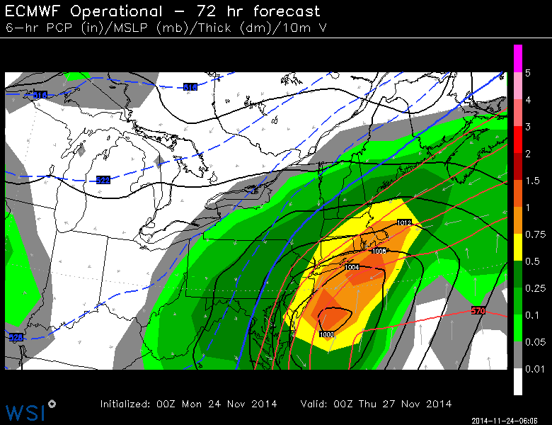
That said, for the fact EURO came east and looks more like the UKMET...I think this was a good run. It should have been a little colder, imo
_________________
_______________________________________________________________________________________________________
CLICK HERE to view NJ Strong Snowstorm Classifications
Frank_Wx- Godzilla Seeker
- Posts : 21305
Reputation : 328
Join date : 2013-01-05
Age : 31
Location : Jersey City, NJ -
Re: 11/26 Strong Coastal Storm Possible
![]() by Snow88 Mon Nov 24, 2014 1:24 am
by Snow88 Mon Nov 24, 2014 1:24 am
Snow88- Senior Enthusiast
- Posts : 2193
Reputation : 4
Join date : 2013-01-09
Age : 35
Location : Brooklyn, NY
Re: 11/26 Strong Coastal Storm Possible
![]() by NjWeatherGuy Mon Nov 24, 2014 1:34 am
by NjWeatherGuy Mon Nov 24, 2014 1:34 am

NjWeatherGuy- Advanced Forecaster

- Posts : 4100
Reputation : 28
Join date : 2013-01-06
Location : Belle Mead, NJ
Re: 11/26 Strong Coastal Storm Possible
![]() by SoulSingMG Mon Nov 24, 2014 1:52 am
by SoulSingMG Mon Nov 24, 2014 1:52 am
He said 00z euro actually shows heavy, wet snow blanketing DC to NYC to BOS & a travel nightmare will unfold.
Any of that make sense to you guys?
SoulSingMG- Senior Enthusiast
- Posts : 2853
Reputation : 74
Join date : 2013-12-11
Location : Long Island City, NY
Re: 11/26 Strong Coastal Storm Possible
![]() by algae888 Mon Nov 24, 2014 4:46 am
by algae888 Mon Nov 24, 2014 4:46 am
6z
00z


algae888- Advanced Forecaster
- Posts : 5311
Reputation : 46
Join date : 2013-02-05
Age : 61
Location : mt. vernon, new york
Re: 11/26 Strong Coastal Storm Possible
![]() by algae888 Mon Nov 24, 2014 5:07 am
by algae888 Mon Nov 24, 2014 5:07 am
algae888- Advanced Forecaster
- Posts : 5311
Reputation : 46
Join date : 2013-02-05
Age : 61
Location : mt. vernon, new york
Re: 11/26 Strong Coastal Storm Possible
![]() by algae888 Mon Nov 24, 2014 5:13 am
by algae888 Mon Nov 24, 2014 5:13 am
MODELS HAVE COME INTO SIGNIFICANTLY BETTER AGREEMENT WITH THE 00Z
RUNS ON THE STORM SYSTEM THAT LIKELY WILL IMPACT THE AREA FROM LATE
TUESDAY NIGHT INTO THURSDAY MORNING. THE 00Z ECMWF HAS SHIFTED ITS
STORM TRACK TO THE EAST - BUT STILL REMAINS A WESTERN OUTLIER
COMPARED TO ALL OTHER GUIDANCE. THE NAM APPEARS TO BE A
WEAKER/EASTERN OUTLIER. AS A RESULT BASED FORECAST TUESDAY
NIGHT-THURSDAY ON A BLEND OF THE GFS/GEFS/SREF/CMC.
they think low will pass near benchmark...
FOR NOW...THE CONSENSUS IS GROWING FOR THE LOW TO TRACK NEAR OR JUST
TO THE EAST OF THE 40N/70W BENCHMARK WEDNESDAY NIGHT...REACHING NEAR
NOVA SCOTIA BY THURSDAY MORNING.
algae888- Advanced Forecaster
- Posts : 5311
Reputation : 46
Join date : 2013-02-05
Age : 61
Location : mt. vernon, new york
Re: 11/26 Strong Coastal Storm Possible
![]() by skinsfan1177 Mon Nov 24, 2014 5:15 am
by skinsfan1177 Mon Nov 24, 2014 5:15 am

skinsfan1177- Senior Enthusiast
- Posts : 4485
Reputation : 35
Join date : 2013-01-07
Age : 46
Location : Point Pleasant Boro
Re: 11/26 Strong Coastal Storm Possible
![]() by algae888 Mon Nov 24, 2014 5:16 am
by algae888 Mon Nov 24, 2014 5:16 am
BASED ON THE ABOVE...THERE IS THE POTENTIAL FOR 6-10 INCHES OF SNOW
ACROSS INTERIOR PORTIONS OF THE LOWER HUDSON VALLEY/NE NJ AND 4-8
INCHES OF SNOW ACROSS INTERIOR S CT. IN COLLABORATION WITH
SURROUNDING WFOS...HAVE ISSUED A WINTER STORM WATCH FOR THESE AREAS
FROM 12Z WEDNESDAY-12Z THURSDAY FOR INTERIOR PORTIONS OF THE LOWER
HUDSON VALLEY AND NE NJ AND FROM 12Z WEDNESDAY UNTIL 15Z THURSDAY
FOR INTERIOR S CT.
THERE WILL BE A VERY SHARP DROP OFF BETWEEN AREAS RECEIVING WARNING
LEVEL SNOWS AND THOSE RECEIVING MAYBE A SLUSHY INCH OR SO DEPENDING
ON EXACTLY WHERE THE RAIN/SNOW LINE SETS UP ON WEDNESDAY AND ON HOW
QUICKLY IT PUSHES TO THE SOUTH AND EAST WEDNESDAY NIGHT. GIVEN THE
CONTINUED UNCERTAINTY IN THE STORM TRACK...THERE IS STILL A LOW
CHANCE FOR REACHING WARNING LEVEL SNOWS ACROSS THE REMAINDER OF NE
NJ/NYC/COASTAL S CT AND ALL BUT E SUFFOLK COUNTY ON LONG ISLAND.
WILL CONTINUE TO HIGHLIGHT THIS THREAT IN THE HWO.
algae888- Advanced Forecaster
- Posts : 5311
Reputation : 46
Join date : 2013-02-05
Age : 61
Location : mt. vernon, new york
Re: 11/26 Strong Coastal Storm Possible
![]() by algae888 Mon Nov 24, 2014 5:17 am
by algae888 Mon Nov 24, 2014 5:17 am
skinsfan1177 wrote:Easterly trend has started good for coastal areas
skins we still have a low chance of warning level snows. going to be a close call
algae888- Advanced Forecaster
- Posts : 5311
Reputation : 46
Join date : 2013-02-05
Age : 61
Location : mt. vernon, new york
Re: 11/26 Strong Coastal Storm Possible
![]() by docstox12 Mon Nov 24, 2014 5:32 am
by docstox12 Mon Nov 24, 2014 5:32 am

docstox12- Wx Statistician Guru

- Posts : 8504
Reputation : 222
Join date : 2013-01-07
Age : 73
Location : Monroe NY
Re: 11/26 Strong Coastal Storm Possible
![]() by algae888 Mon Nov 24, 2014 5:37 am
by algae888 Mon Nov 24, 2014 5:37 am
LETS TALK TURKEY....FOR SNOW AMOUNTS, STILL EXPECT A PRETTY SHARP
GRADIENT ROUGHLY AROUND THE I 95 CORRIDOR. NORTH AND WEST OF THE
FALL LINE COULD SEE AMOUNTS FROM 2 UP TO 8 INCHES (THE HIGHEST
AMOUNTS SHOULD BE LIMITED TO THE HIGHER TERRAIN IN NW NJ AND THE
POCONOS). EAST OF THE FALL LINE COULD SEE UP TO 2 INCHES. HOWEVER,
COASTAL LOCATIONS WILL LIKELY NOT SEE ANY ACCUMULATIONS AS WITH
THE WATER TEMPERATURE STILL IN THE 50S, THE ONSHORE FLOW SHOULD
KEEP THEM WELL ABOVE FREEZING THROUGH OUT THE EVENT. THE CAVEAT TO
ALL OF THIS IS THAT THE LOCATION OF THE RAIN/SNOW TRANSITION AND
EVEN SNOW RATIOS IS VERY MUCH DEPENDENT ON THE TEMPERATURE, AND
WITH THE PREVIOUSLY MENTIONED COLD OUTLIER OF THE GFS, THERE IS
POOR MODEL AGREEMENT ON THIS ISSUE, SO SNOW AMOUNTS REMAIN
UNCERTAIN.
algae888- Advanced Forecaster
- Posts : 5311
Reputation : 46
Join date : 2013-02-05
Age : 61
Location : mt. vernon, new york
Re: 11/26 Strong Coastal Storm Possible
![]() by jmanley32 Mon Nov 24, 2014 5:42 am
by jmanley32 Mon Nov 24, 2014 5:42 am

jmanley32- Senior Enthusiast
- Posts : 20516
Reputation : 108
Join date : 2013-12-12
Age : 42
Location : Yonkers, NY
Re: 11/26 Strong Coastal Storm Possible
![]() by jmanley32 Mon Nov 24, 2014 5:43 am
by jmanley32 Mon Nov 24, 2014 5:43 am
jmanley32- Senior Enthusiast
- Posts : 20516
Reputation : 108
Join date : 2013-12-12
Age : 42
Location : Yonkers, NY
Re: 11/26 Strong Coastal Storm Possible
![]() by docstox12 Mon Nov 24, 2014 5:47 am
by docstox12 Mon Nov 24, 2014 5:47 am
docstox12- Wx Statistician Guru
- Posts : 8504
Reputation : 222
Join date : 2013-01-07
Age : 73
Location : Monroe NY
Re: 11/26 Strong Coastal Storm Possible
![]() by algae888 Mon Nov 24, 2014 5:49 am
by algae888 Mon Nov 24, 2014 5:49 am
jmanley32 wrote:Oh lordy Al, how ever Mt. Holly went ape two nights ago about how bad it would be and now saying this, so I dunno if I buy this yet. Ready earlier posts that the cold may be ok.
jman as of right now we are on the fall line. very close. one thing I wish to see from models today is for storm to slow down because most off the heavier precip looks to fall during the day as per 6z runs. even if it's snow going to be hard to accum. during daylight hours. with out any blocking do not think this will happen.
algae888- Advanced Forecaster
- Posts : 5311
Reputation : 46
Join date : 2013-02-05
Age : 61
Location : mt. vernon, new york
Re: 11/26 Strong Coastal Storm Possible
![]() by algae888 Mon Nov 24, 2014 5:56 am
by algae888 Mon Nov 24, 2014 5:56 am
docstox12 wrote:Unless this ticks east, a classic borderline Metro Area snowstorm with I 95 as the battleground.
hey doc any houses for sale up there. lived in Bronx and lower Westchester my whole life. consistently on the r/s line. can't take many more of these nail bitters.
algae888- Advanced Forecaster
- Posts : 5311
Reputation : 46
Join date : 2013-02-05
Age : 61
Location : mt. vernon, new york
Re: 11/26 Strong Coastal Storm Possible
![]() by docstox12 Mon Nov 24, 2014 6:03 am
by docstox12 Mon Nov 24, 2014 6:03 am
docstox12- Wx Statistician Guru
- Posts : 8504
Reputation : 222
Join date : 2013-01-07
Age : 73
Location : Monroe NY
Re: 11/26 Strong Coastal Storm Possible
![]() by algae888 Mon Nov 24, 2014 6:12 am
by algae888 Mon Nov 24, 2014 6:12 am
really! I live a town over from your fiancée's mom and work at 225th street, I drive by monte all the time.docstox12 wrote:I hear ya,Al.Lived in Mahwah NJ, a little further N of I 95 but always turned into slop being too close to the City. We would get amounts halfway between the City and HV in Mahwah.The HV is definitely 3 to 5 degrees colder, plus elevation than Mahwah which works out great for these borderline storms.Come on up here and join CP and me, houses cost less than Bronx-Westchester.BTW my Fiancee's Mom lives in Tuckahoe and Fiancee works at Montefiore on 233rd St.
algae888- Advanced Forecaster
- Posts : 5311
Reputation : 46
Join date : 2013-02-05
Age : 61
Location : mt. vernon, new york
Re: 11/26 Strong Coastal Storm Possible
![]() by docstox12 Mon Nov 24, 2014 6:18 am
by docstox12 Mon Nov 24, 2014 6:18 am
docstox12- Wx Statistician Guru
- Posts : 8504
Reputation : 222
Join date : 2013-01-07
Age : 73
Location : Monroe NY
Page 17 of 23 • 1 ... 10 ... 16, 17, 18 ... 23 ![]()
|
|
|