
 Search
Possible Nor'easter Dec. 9th-10th
Page 14 of 20 •  1 ... 8 ... 13, 14, 15 ... 20
 ![]()
Re: Possible Nor'easter Dec. 9th-10th
![]() by amugs Sat Dec 06, 2014 11:35 pm
by amugs Sat Dec 06, 2014 11:35 pm
The weenie run - one can only hope and pray it happens
amugs- Advanced Forecaster - Mod

- Posts : 15093
Join date : 2013-01-07
Re: Possible Nor'easter Dec. 9th-10th
![]() by jmanley32 Sat Dec 06, 2014 11:44 pm
by jmanley32 Sat Dec 06, 2014 11:44 pm
jmanley32- Senior Enthusiast

- Posts : 20517
Join date : 2013-12-12
Re: Possible Nor'easter Dec. 9th-10th
![]() by Frank_Wx Sat Dec 06, 2014 11:50 pm
by Frank_Wx Sat Dec 06, 2014 11:50 pm

_________________
_______________________________________________________________________________________________________
CLICK HERE to view NJ Strong Snowstorm Classifications

Frank_Wx- Godzilla Seeker

- Posts : 21305
Reputation : 328
Join date : 2013-01-05
Age : 31
Location : Jersey City, NJ -

Re: Possible Nor'easter Dec. 9th-10th
![]() by jmanley32 Sat Dec 06, 2014 11:54 pm
by jmanley32 Sat Dec 06, 2014 11:54 pm

jmanley32- Senior Enthusiast
- Posts : 20517
Reputation : 108
Join date : 2013-12-12
Age : 42
Location : Yonkers, NY
Re: Possible Nor'easter Dec. 9th-10th
![]() by jmanley32 Sat Dec 06, 2014 11:58 pm
by jmanley32 Sat Dec 06, 2014 11:58 pm
jmanley32- Senior Enthusiast
- Posts : 20517
Reputation : 108
Join date : 2013-12-12
Age : 42
Location : Yonkers, NY
Re: Possible Nor'easter Dec. 9th-10th
![]() by Frank_Wx Sun Dec 07, 2014 12:16 am
by Frank_Wx Sun Dec 07, 2014 12:16 am

_________________
_______________________________________________________________________________________________________
CLICK HERE to view NJ Strong Snowstorm Classifications
Frank_Wx- Godzilla Seeker
- Posts : 21305
Reputation : 328
Join date : 2013-01-05
Age : 31
Location : Jersey City, NJ -
Re: Possible Nor'easter Dec. 9th-10th
![]() by Frank_Wx Sun Dec 07, 2014 12:17 am
by Frank_Wx Sun Dec 07, 2014 12:17 am
_________________
_______________________________________________________________________________________________________
CLICK HERE to view NJ Strong Snowstorm Classifications
Frank_Wx- Godzilla Seeker
- Posts : 21305
Reputation : 328
Join date : 2013-01-05
Age : 31
Location : Jersey City, NJ -
Re: Possible Nor'easter Dec. 9th-10th
![]() by jmanley32 Sun Dec 07, 2014 12:20 am
by jmanley32 Sun Dec 07, 2014 12:20 am
jmanley32- Senior Enthusiast
- Posts : 20517
Reputation : 108
Join date : 2013-12-12
Age : 42
Location : Yonkers, NY
Re: Possible Nor'easter Dec. 9th-10th
![]() by Frank_Wx Sun Dec 07, 2014 1:10 am
by Frank_Wx Sun Dec 07, 2014 1:10 am

Flooding rain on the Euro. GFS is alone.
_________________
_______________________________________________________________________________________________________
CLICK HERE to view NJ Strong Snowstorm Classifications
Frank_Wx- Godzilla Seeker
- Posts : 21305
Reputation : 328
Join date : 2013-01-05
Age : 31
Location : Jersey City, NJ -
Re: Possible Nor'easter Dec. 9th-10th
![]() by Frank_Wx Sun Dec 07, 2014 1:17 am
by Frank_Wx Sun Dec 07, 2014 1:17 am
The euro actually retrogrades the low back into the area on THURSDAY
The heavy rain comes on Tuesday. Wednesday is a lull
SNOW STORM

_________________
_______________________________________________________________________________________________________
CLICK HERE to view NJ Strong Snowstorm Classifications
Frank_Wx- Godzilla Seeker
- Posts : 21305
Reputation : 328
Join date : 2013-01-05
Age : 31
Location : Jersey City, NJ -
Re: Possible Nor'easter Dec. 9th-10th
![]() by Frank_Wx Sun Dec 07, 2014 1:26 am
by Frank_Wx Sun Dec 07, 2014 1:26 am
_________________
_______________________________________________________________________________________________________
CLICK HERE to view NJ Strong Snowstorm Classifications
Frank_Wx- Godzilla Seeker
- Posts : 21305
Reputation : 328
Join date : 2013-01-05
Age : 31
Location : Jersey City, NJ -
Re: Possible Nor'easter Dec. 9th-10th
![]() by Frank_Wx Sun Dec 07, 2014 1:46 am
by Frank_Wx Sun Dec 07, 2014 1:46 am
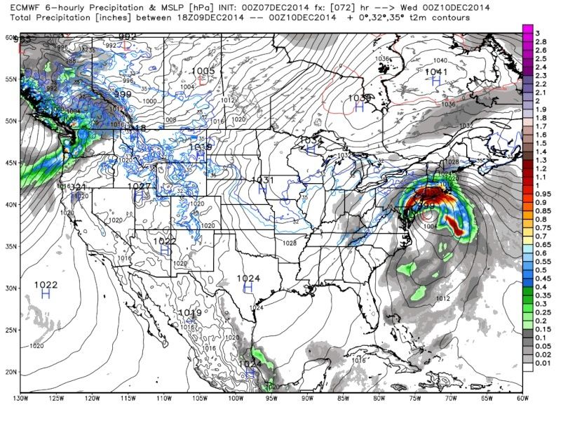
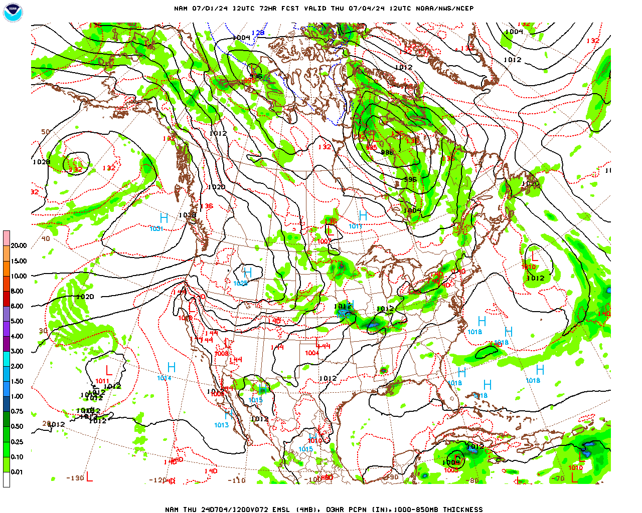
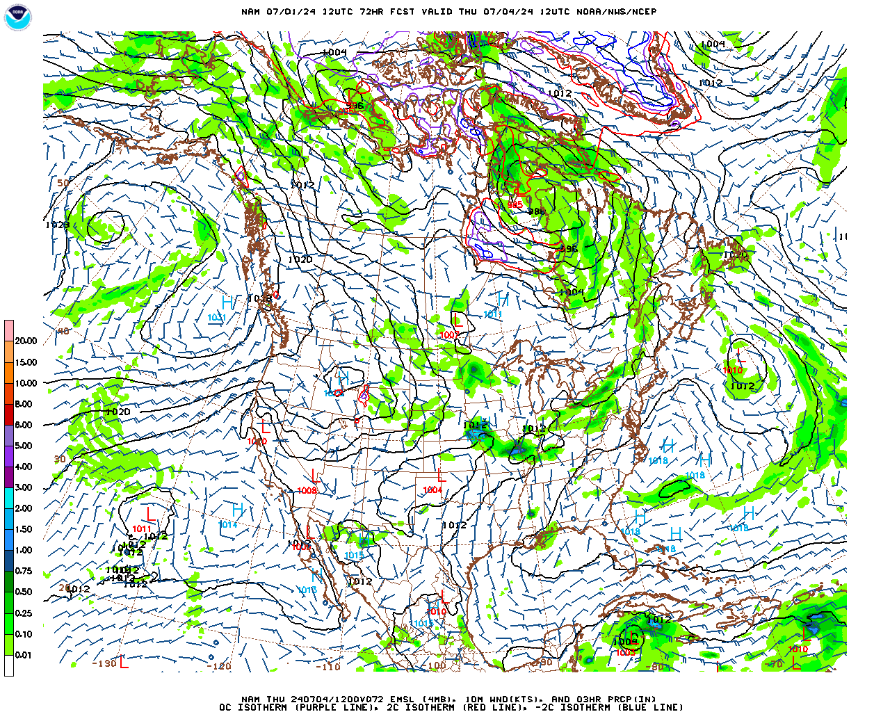
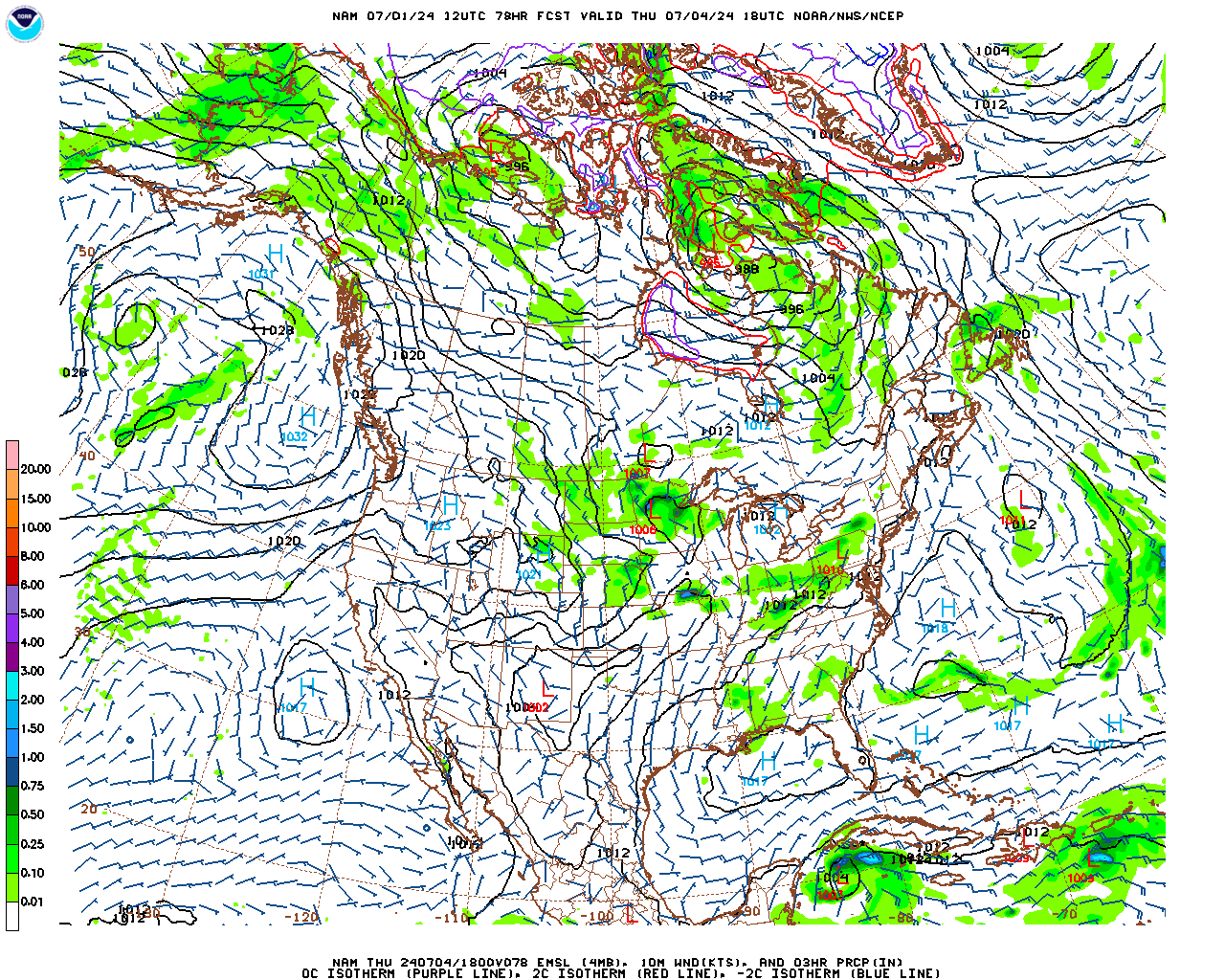
Tuesday into Wednesday morning most of us are experiencing rain.A 1000mb low is crawling up the coast Tuesday during the day and producing heavy rainfall throughout the entire afternoon. It does not begin to subside until later that day. By late Tuesday night, the CCB has pushed itself into central PA. Probably a 2-3 inch rainfall for much of us.
That's part 1
Part 2 commences late Wednesday night into Thursday. The energy involved with the primary low begins to transfer to a secondary low where convection was building in the eastern flank of the storm. So now we have a new LLC that is retrograding off the Atlantic back into the northeast. By this point, 850 mb temps are cold enough to promote frozen precip, though the surface is warm. I do not have soundings, but I would think most of us verbatim get a decent snowfall out of it.
Crazy run. Not sure H5 works out that way
_________________
_______________________________________________________________________________________________________
CLICK HERE to view NJ Strong Snowstorm Classifications
Frank_Wx- Godzilla Seeker
- Posts : 21305
Reputation : 328
Join date : 2013-01-05
Age : 31
Location : Jersey City, NJ -
Re: Possible Nor'easter Dec. 9th-10th
![]() by algae888 Sun Dec 07, 2014 7:36 am
by algae888 Sun Dec 07, 2014 7:36 am
HEAVIEST RAIN WILL DEVELOP TUESDAY MORNING...AIDED BY APPROACH OF
SOUTHERN STREAM SHORTWAVE...DEVELOPMENT OF A COUPLED JET
STRUCTURE...STRONG MID-LEVEL FRONTOGENESIS...AND STRONG ATLANTIC
INFLOW (65-75 KT 850 MB EASTERLY JET) BRINGING IN PWATS 1-2 STDS
ABOVE NORMAL. SEE HYDRO SECTION BELOW FOR MORE DETAILS OF IMPACTS.
BASED ON CONSENSUS TRACK...THIS FORCING AND HEAVY RAIN WOULD MOVE
NORTH OF LI/CT TUE EVE WITH DRY-SLOTTING. BUT FOR THE WESTERN HALF
OF THE TRI-STATE POTENTIAL FOR DEFORMATION BANDING TO LINGER
ACROSS WESTERN HALF OF TRI-STATE AS UPPER LOW MOVES OVERHEAD TUE
NIGHT INTO WED MORNING CONTINUING MODERATE TO HEAVY BANDED PRECIP.
POTENTIAL IS THERE FOR CAA AND DYNAMIC COOLING TO CHANGE PRECIP TO
SNOW ACROSS INTERIOR AND ELEVATED PORTIONS OF LOWER HUDSON VALLEY
AND NE NJ...WITH A PERIOD OF MODERATE TO HEAVY SNOW/SLEET AND
SEVERAL INCHES OF SNOW ACCUM POSSIBLE TUE NIGHT INTO WED MORNING.
CONFIDENCE ON WHERE THIS FEATURE SETS UP IS LOW AT THIS
POINT...BUT WILL MENTION POTENTIAL IN HWO AND REFLECTE IN SNOW
TOTALS.
I think its primarily rain Tuesday (a lot) and then we will have to see what happens on the back end. as others have said back end snow doesn't really happen to often for coastal areas. we shall see.

algae888- Advanced Forecaster

- Posts : 5311
Reputation : 46
Join date : 2013-02-05
Age : 61
Location : mt. vernon, new york
Re: Possible Nor'easter Dec. 9th-10th
![]() by algae888 Sun Dec 07, 2014 7:39 am
by algae888 Sun Dec 07, 2014 7:39 am
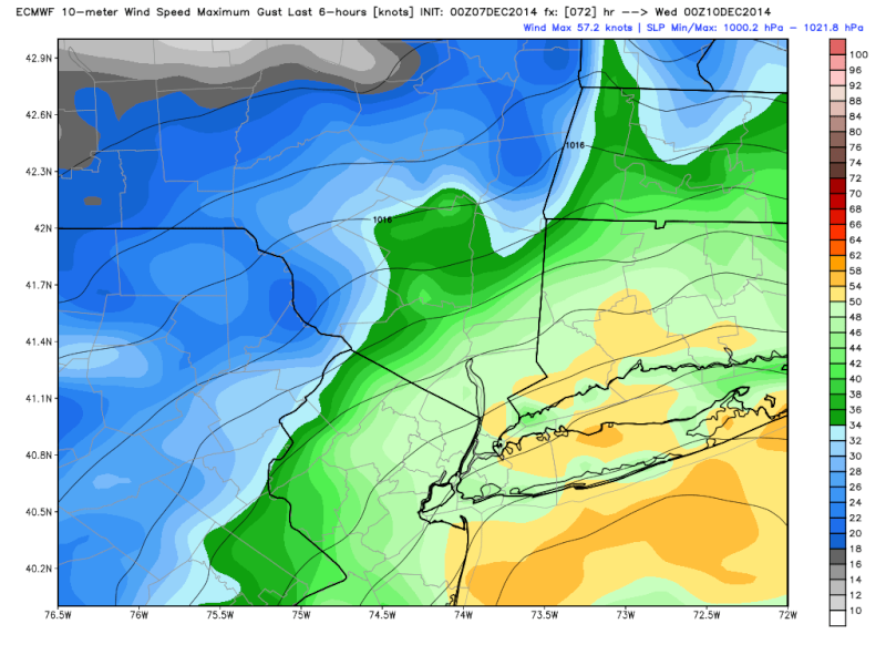
FOR THE WIND THREAT...ECMWF AND GFS SIGNALING POTENTIAL FOR 950 MB
WINDS TO REACH 55-60 KT LATE TUESDAY AHEAD OF THE LOW PRESSURE. A
STRONG LOW- LEVEL INVERSION WILL NOT ALLOW THIS ALL TO MIX
DOWN...BUT A PERIOD OF NE WINDS 25 TO 35 MPH WITH GUSTS TO 50 MPH
ARE POSSIBLE ALONG THE COAST...PARTICULARLY EASTERN LI/SE CT TUE
AFT/EVE. HIGH WIND POTENTIAL LOOKS TO BE SLIGHT AT THIS POINT
algae888- Advanced Forecaster
- Posts : 5311
Reputation : 46
Join date : 2013-02-05
Age : 61
Location : mt. vernon, new york
Re: Possible Nor'easter Dec. 9th-10th
![]() by jmanley32 Sun Dec 07, 2014 9:09 am
by jmanley32 Sun Dec 07, 2014 9:09 am
jmanley32- Senior Enthusiast
- Posts : 20517
Reputation : 108
Join date : 2013-12-12
Age : 42
Location : Yonkers, NY
jmanley32- Senior Enthusiast
- Posts : 20517
Reputation : 108
Join date : 2013-12-12
Age : 42
Location : Yonkers, NY
jmanley32- Senior Enthusiast
- Posts : 20517
Reputation : 108
Join date : 2013-12-12
Age : 42
Location : Yonkers, NY
Re: Possible Nor'easter Dec. 9th-10th
![]() by jmanley32 Sun Dec 07, 2014 9:17 am
by jmanley32 Sun Dec 07, 2014 9:17 am
Last edited by jmanley32 on Sun Dec 07, 2014 9:21 am; edited 1 time in total
jmanley32- Senior Enthusiast
- Posts : 20517
Reputation : 108
Join date : 2013-12-12
Age : 42
Location : Yonkers, NY
Re: Possible Nor'easter Dec. 9th-10th
![]() by CPcantmeasuresnow Sun Dec 07, 2014 9:17 am
by CPcantmeasuresnow Sun Dec 07, 2014 9:17 am
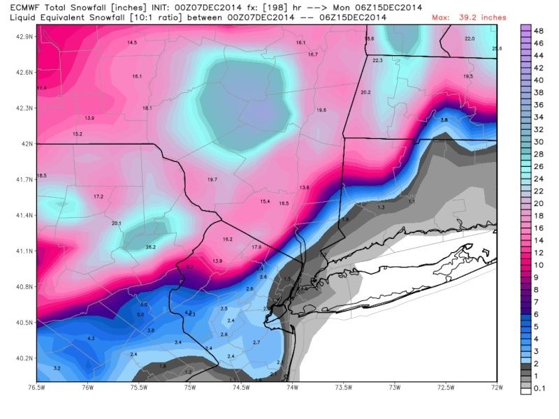
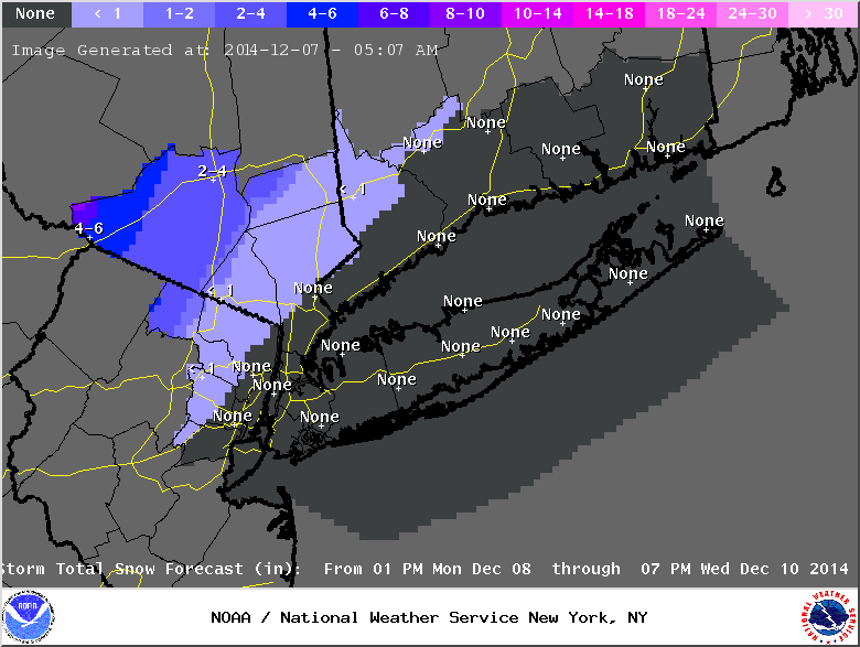
jmanley32 wrote:Well they havent completely ruled it out so IMO it could still be a concern (and yes I mean concern as you are right about the saturation as I said before, which is high according to NWS map, not including this week). I think wind will all depending on how strong the LP is and I do not think that ha completely been ironed out yet. Verbatim snow stays just west of tri state snow map is nuts:
From that map heavy snow plasters part of the tri-state area. 40 miles north and west of midtown get over a foot of snow, parts of the HV get over 20 inches.
I don't buy it because again like the pre Thanksgiving storm this his has all the makings of a nowcast and possibly over several days. I don't think anyone has a solid foundation yet on what this is going to do. Very very complex.

CPcantmeasuresnow- Wx Statistician Guru

- Posts : 7274
Reputation : 230
Join date : 2013-01-07
Age : 103
Location : Eastern Orange County, NY
Re: Possible Nor'easter Dec. 9th-10th
![]() by jmanley32 Sun Dec 07, 2014 9:20 am
by jmanley32 Sun Dec 07, 2014 9:20 am
jmanley32- Senior Enthusiast
- Posts : 20517
Reputation : 108
Join date : 2013-12-12
Age : 42
Location : Yonkers, NY
Re: Possible Nor'easter Dec. 9th-10th
![]() by jmanley32 Sun Dec 07, 2014 9:24 am
by jmanley32 Sun Dec 07, 2014 9:24 am
THIS HAZARDOUS WEATHER OUTLOOK IS FOR SOUTHERN
CONNECTICUT...NORTHEAST NEW JERSEY AND SOUTHEAST NEW YORK.
.DAY ONE...TODAY AND TONIGHT.
HAZARDOUS WEATHER NOT EXPECTED AT THIS TIME.
.DAYS TWO THROUGH SEVEN...MONDAY THROUGH SATURDAY.
A SLOW MOVING COASTAL STORM WILL AFFECT THE REGION MONDAY NIGHT
THROUGH TUESDAY NIGHT WITH A BIT OR WINTRY PRECIP...BUT MAINLY
HEAVY RAIN AND STRONG WINDS. ALTHOUGH THERE IS STILL SOME
UNCERTAINTY ON TIMING...INTENSITY...AND TRACK OF THIS LOW PRESSURE
SYSTEM...THERE IS A LOW POTENTIAL FOR FLASH FLOODING ON TUESDAY.
.SPOTTER INFORMATION STATEMENT...
SPOTTER ACTIVATION IS NOT EXPECTED AT THIS TIME.
jmanley32- Senior Enthusiast
- Posts : 20517
Reputation : 108
Join date : 2013-12-12
Age : 42
Location : Yonkers, NY
Re: Possible Nor'easter Dec. 9th-10th
![]() by algae888 Sun Dec 07, 2014 9:59 am
by algae888 Sun Dec 07, 2014 9:59 am
algae888- Advanced Forecaster
- Posts : 5311
Reputation : 46
Join date : 2013-02-05
Age : 61
Location : mt. vernon, new york
Re: Possible Nor'easter Dec. 9th-10th
![]() by mancave25 Sun Dec 07, 2014 10:46 am
by mancave25 Sun Dec 07, 2014 10:46 am
mancave25- Posts : 112
Reputation : 0
Join date : 2014-02-05
Re: Possible Nor'easter Dec. 9th-10th
![]() by Snow88 Sun Dec 07, 2014 10:50 am
by Snow88 Sun Dec 07, 2014 10:50 am

Snow88- Senior Enthusiast
- Posts : 2193
Reputation : 4
Join date : 2013-01-09
Age : 35
Location : Brooklyn, NY
Re: Possible Nor'easter Dec. 9th-10th
![]() by jmanley32 Sun Dec 07, 2014 10:55 am
by jmanley32 Sun Dec 07, 2014 10:55 am
jmanley32- Senior Enthusiast
- Posts : 20517
Reputation : 108
Join date : 2013-12-12
Age : 42
Location : Yonkers, NY
Re: Possible Nor'easter Dec. 9th-10th
![]() by jmanley32 Sun Dec 07, 2014 10:58 am
by jmanley32 Sun Dec 07, 2014 10:58 am
jmanley32- Senior Enthusiast
- Posts : 20517
Reputation : 108
Join date : 2013-12-12
Age : 42
Location : Yonkers, NY
Re: Possible Nor'easter Dec. 9th-10th
![]() by CPcantmeasuresnow Sun Dec 07, 2014 12:21 pm
by CPcantmeasuresnow Sun Dec 07, 2014 12:21 pm
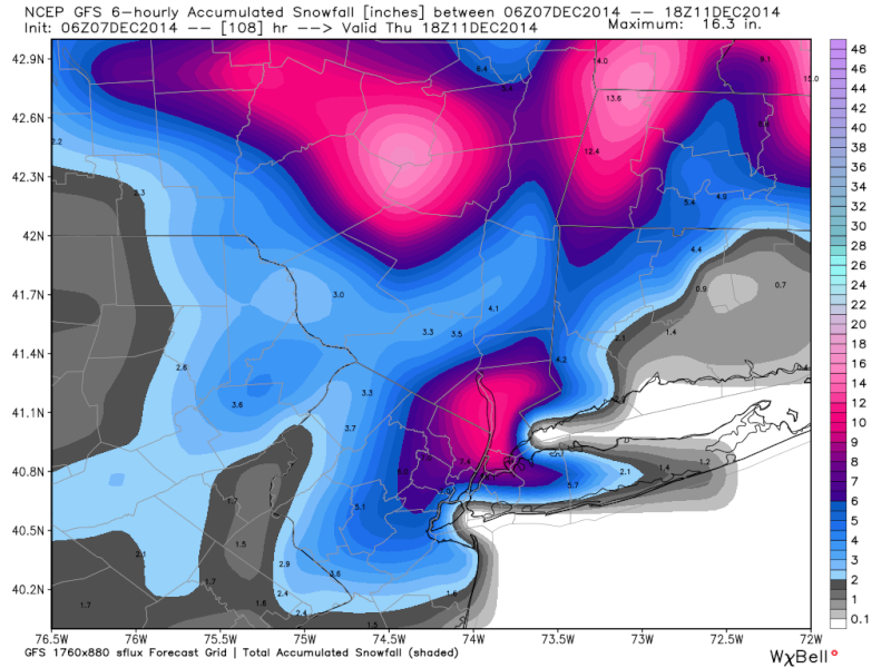
jmanley32 wrote:NWs first snow map, everything to the north as of now.
Interesting map for Orange County, 1-2 inches on the southern border and 8-10 inches in the extreme northwest portion. I doubt that will verify one way or the other, but I guess it's as good a first guess as any here. It also doesn't include anything for possible Thursday retrograde.
There's still so much to iron out this week.
CPcantmeasuresnow- Wx Statistician Guru
- Posts : 7274
Reputation : 230
Join date : 2013-01-07
Age : 103
Location : Eastern Orange County, NY
Page 14 of 20 • 1 ... 8 ... 13, 14, 15 ... 20 ![]()
|
|
|