
 Search
Official Long Range Thread 5.0
Page 2 of 40 •  1, 2, 3 ... 21 ... 40
 ![]()
Re: Official Long Range Thread 5.0
![]() by docstox12 Sun Dec 14, 2014 5:08 pm
by docstox12 Sun Dec 14, 2014 5:08 pm
Happy days!!!
docstox12- Wx Statistician Guru

- Posts : 8504
Join date : 2013-01-07
Re: Official Long Range Thread 5.0
![]() by rb924119 Sun Dec 14, 2014 5:11 pm
by rb924119 Sun Dec 14, 2014 5:11 pm
rb924119- Meteorologist

- Posts : 6890
Join date : 2013-02-06
Re: Official Long Range Thread 5.0
![]() by amugs Sun Dec 14, 2014 5:15 pm
by amugs Sun Dec 14, 2014 5:15 pm
So please do not speak of the GooFus IMHO until we are around Thursday when it starts to catch on or Friday.
_________________
Mugs
AKA:King: Snow Weenie
Self Proclaimed
WINTER 2014-15 : 55.12" +.02 for 6 coatings (avg. 35")
WINTER 2015-16 Total - 29.8" (Avg 35")
WINTER 2016-17 : 39.5" so far

amugs- Advanced Forecaster - Mod

- Posts : 15093
Reputation : 213
Join date : 2013-01-07
Age : 54
Location : Hillsdale,NJ
Re: Official Long Range Thread 5.0
![]() by jmanley32 Sun Dec 14, 2014 5:34 pm
by jmanley32 Sun Dec 14, 2014 5:34 pm

jmanley32- Senior Enthusiast

- Posts : 20516
Reputation : 108
Join date : 2013-12-12
Age : 42
Location : Yonkers, NY
Re: Official Long Range Thread 5.0
![]() by sroc4 Sun Dec 14, 2014 5:55 pm
by sroc4 Sun Dec 14, 2014 5:55 pm
Hey everyone....
With the holidays coming on I figured I needed to start saying something about the sequence of THREE impressive storms which will affect parts of the nation.
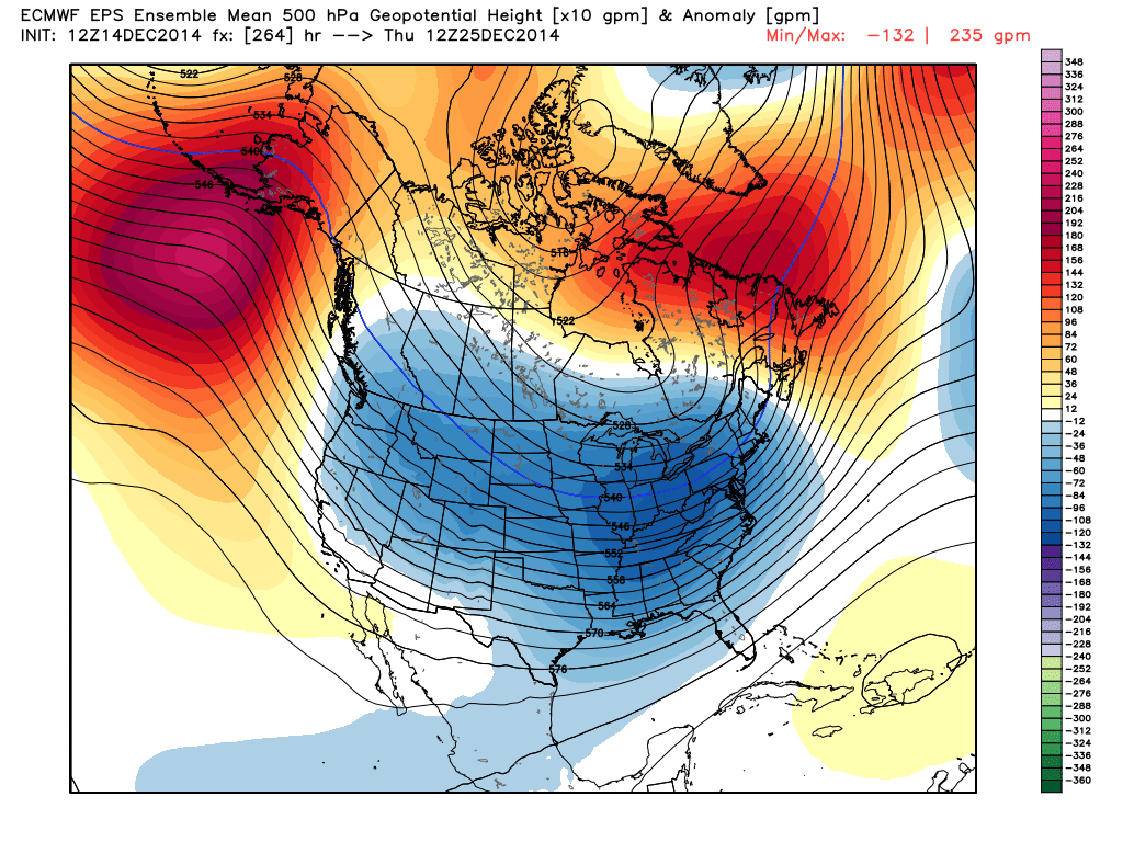
1) December 19 - 23. "The Appetizer". Cyclogenesis near Galveston TX (origins in system now off the coast of California), then track to Columbus GA....Fayetteville NC.....200 miles south of Nantucket MA. Heavy rain and thunder Texas and Deep South, some severe weather threats close to the coast. Steady rain along and above Interstate 20 with snow and sleet involved in lower/middle Appalachia. Rain that forms along the Atlantic Coastal Plain above Richmond VA to Boston MA will shift to mostly snow. Threats for accumulating snow are rising in the Mid-Atlantic region (DCA....BWI....PHL....NYC), and if ECMWF scheme is right at least moderate amounts of the white stuff are possible.
2) December 22 - 26. The "Big Kahuna" storm. Upper level disturbance digs into northern Mexico. Reforms into frontal wave near Corpus Christi TX. Deepens as shortwave energy drops southward from Montana, which sets up a east, then northeast motion. Estimated track now is along Gulf Coast through New Orleans LA, then Valdosta GA....Raleigh NC....Salisbury MD....Concord NH....Fort Kent ME. Yes, path scenario is shifting rightward on models and may trend to purely coastal solution that analogs favor! This system will drop lots of snow on Appalachia and perhaps the lower Great Lakes, while being the draw for much colder air east of the Rocky Mountains.
3) December 27 - 30. "The Finisher" looks to organize near Brownsville TX, progress to Jacksonville FL, then move up and off of the East Coast by 125 - 175 miles through the 40/70 Benchmark. Analogs and ensemble depictions point toward a serious snow event in parts of Dixie and the Atlantic Coastal Plain. And yes, it looks VERY cold east of the Rocky Mountains in the 11 - 15 day time frame.
Happy Holidays!
_________________
"In weather and in life, there's no winning and losing; there's only winning and learning."
WINTER 2012/2013 TOTALS 43.65"WINTER 2017/2018 TOTALS 62.85" WINTER 2022/2023 TOTALS 4.9"
WINTER 2013/2014 TOTALS 64.85"WINTER 2018/2019 TOTALS 14.25" WINTER 2023/2024 TOTALS 13.1"
WINTER 2014/2015 TOTALS 71.20"WINTER 2019/2020 TOTALS 6.35"
WINTER 2015/2016 TOTALS 35.00"WINTER 2020/2021 TOTALS 37.75"
WINTER 2016/2017 TOTALS 42.25"WINTER 2021/2022 TOTALS 31.65"

sroc4- Admin

- Posts : 8331
Reputation : 301
Join date : 2013-01-07
Location : Wading River, LI
Re: Official Long Range Thread 5.0
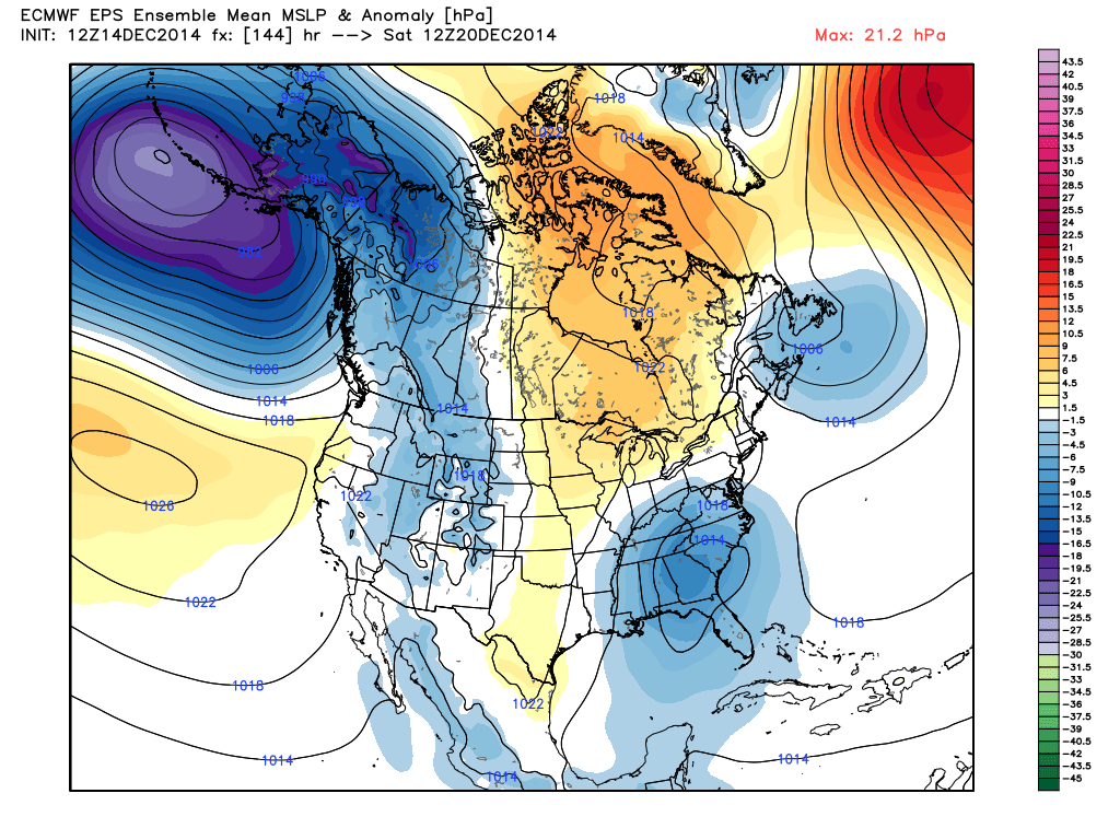
![]() by Frank_Wx Sun Dec 14, 2014 6:00 pm
by Frank_Wx Sun Dec 14, 2014 6:00 pm

Euro ensembles...nice
_________________
_______________________________________________________________________________________________________
CLICK HERE to view NJ Strong Snowstorm Classifications

Frank_Wx- Godzilla Seeker
- Posts : 21305
Reputation : 328
Join date : 2013-01-05
Age : 31
Location : Jersey City, NJ -

Re: Official Long Range Thread 5.0
![]() by Frank_Wx Sun Dec 14, 2014 6:06 pm
by Frank_Wx Sun Dec 14, 2014 6:06 pm
_________________
_______________________________________________________________________________________________________
CLICK HERE to view NJ Strong Snowstorm Classifications
Frank_Wx- Godzilla Seeker
- Posts : 21305
Reputation : 328
Join date : 2013-01-05
Age : 31
Location : Jersey City, NJ -
Re: Official Long Range Thread 5.0
![]() by Frank_Wx Sun Dec 14, 2014 6:08 pm
by Frank_Wx Sun Dec 14, 2014 6:08 pm
_________________
_______________________________________________________________________________________________________
CLICK HERE to view NJ Strong Snowstorm Classifications
Frank_Wx- Godzilla Seeker
- Posts : 21305
Reputation : 328
Join date : 2013-01-05
Age : 31
Location : Jersey City, NJ -
Re: Official Long Range Thread 5.0
![]() by jmanley32 Sun Dec 14, 2014 7:05 pm
by jmanley32 Sun Dec 14, 2014 7:05 pm
jmanley32- Senior Enthusiast
- Posts : 20516
Reputation : 108
Join date : 2013-12-12
Age : 42
Location : Yonkers, NY
Re: Official Long Range Thread 5.0
![]() by Guest Sun Dec 14, 2014 7:29 pm
by Guest Sun Dec 14, 2014 7:29 pm
jmanley32 wrote:Euro also shows the beginnings of what looks to be our possible xmas storm (and it looks strong even way down there. Man imagine if we get SECS, MECS and maybe even a HECS every 10 days or so like the systems have been happening the area will be buried and many of us will be right on the high end of the snowfall contest.
Someone please explain HECS, MECS and SECS!!
Guest- Guest
Re: Official Long Range Thread 5.0
![]() by CPcantmeasuresnow Sun Dec 14, 2014 7:30 pm
by CPcantmeasuresnow Sun Dec 14, 2014 7:30 pm
Last edited by CPcantmeasuresnow on Sun Dec 14, 2014 7:31 pm; edited 1 time in total

CPcantmeasuresnow- Wx Statistician Guru
- Posts : 7274
Reputation : 230
Join date : 2013-01-07
Age : 103
Location : Eastern Orange County, NY
Re: Official Long Range Thread 5.0
![]() by jmanley32 Sun Dec 14, 2014 7:30 pm
by jmanley32 Sun Dec 14, 2014 7:30 pm
Significant east coast storm
major east coast storm
historic east coast storm
At least thats what I remember being told but I am so tired I could be wrong.
: )
jmanley32- Senior Enthusiast
- Posts : 20516
Reputation : 108
Join date : 2013-12-12
Age : 42
Location : Yonkers, NY
Re: Official Long Range Thread 5.0
![]() by Guest Sun Dec 14, 2014 7:33 pm
by Guest Sun Dec 14, 2014 7:33 pm
jmanley32 wrote:Oh syo, lol it took me a explaining too:
Significant east coast storm
major east coast storm
historic east coast storm
At least thats what I remember being told but I am so tired I could be wrong.
: )
Funny that was my guess.
Guest- Guest
Re: Official Long Range Thread 5.0
![]() by amugs Sun Dec 14, 2014 8:14 pm
by amugs Sun Dec 14, 2014 8:14 pm
jmanley32 wrote:Oh syo, lol it took me a explaining too:
Significant east coast storm
major east coast storm
historic east coast storm
At least thats what I remember being told but I am so tired I could be wrong.
: )
BECS = Biblical East Coast Storm - blizzard of 1996 and Superstorm 1993 are considered under this category
_________________
Mugs
AKA:King: Snow Weenie
Self Proclaimed
WINTER 2014-15 : 55.12" +.02 for 6 coatings (avg. 35")
WINTER 2015-16 Total - 29.8" (Avg 35")
WINTER 2016-17 : 39.5" so far
amugs- Advanced Forecaster - Mod
- Posts : 15093
Reputation : 213
Join date : 2013-01-07
Age : 54
Location : Hillsdale,NJ
jmanley32- Senior Enthusiast
- Posts : 20516
Reputation : 108
Join date : 2013-12-12
Age : 42
Location : Yonkers, NY
Re: Official Long Range Thread 5.0
![]() by amugs Sun Dec 14, 2014 8:17 pm
by amugs Sun Dec 14, 2014 8:17 pm
_________________
Mugs
AKA:King: Snow Weenie
Self Proclaimed
WINTER 2014-15 : 55.12" +.02 for 6 coatings (avg. 35")
WINTER 2015-16 Total - 29.8" (Avg 35")
WINTER 2016-17 : 39.5" so far
amugs- Advanced Forecaster - Mod
- Posts : 15093
Reputation : 213
Join date : 2013-01-07
Age : 54
Location : Hillsdale,NJ
Re: Official Long Range Thread 5.0
![]() by amugs Sun Dec 14, 2014 8:20 pm
by amugs Sun Dec 14, 2014 8:20 pm
_________________
Mugs
AKA:King: Snow Weenie
Self Proclaimed
WINTER 2014-15 : 55.12" +.02 for 6 coatings (avg. 35")
WINTER 2015-16 Total - 29.8" (Avg 35")
WINTER 2016-17 : 39.5" so far
amugs- Advanced Forecaster - Mod
- Posts : 15093
Reputation : 213
Join date : 2013-01-07
Age : 54
Location : Hillsdale,NJ
Re: Official Long Range Thread 5.0
![]() by nutleyblizzard Sun Dec 14, 2014 9:25 pm
by nutleyblizzard Sun Dec 14, 2014 9:25 pm
The blizzard of 1996 was my all time favorite snowstorm. Days before the event, it was forecasted to be a southern slider with snow only making it up to Virginia. Four days before the storm hit, Janice Huff was calling for flurries. By 48 hours, the forecast was for a moderate event. By the time we got within 24 hours, forecasters were upping amounts big time. The snow started in my then hometown of Bloomfield at 9am sunday morning, and didn't stop until 1pm monday afternoon. I ended up with 29 inches! I can't even describe how I felt, just pure weenie bliss. Hope to relive that magnitude of a storm sometime soon!amugs wrote:jmanley32 wrote:Oh syo, lol it took me a explaining too:
Significant east coast storm
major east coast storm
historic east coast storm
At least thats what I remember being told but I am so tired I could be wrong.
: )
BECS = Biblical East Coast Storm - blizzard of 1996 and Superstorm 1993 are considered under this category

nutleyblizzard- Senior Enthusiast
- Posts : 1952
Reputation : 41
Join date : 2014-01-30
Age : 58
Location : Nutley, new jersey
Re: Official Long Range Thread 5.0
![]() by mako460 Sun Dec 14, 2014 9:47 pm
by mako460 Sun Dec 14, 2014 9:47 pm
mako460- Pro Enthusiast

- Posts : 346
Reputation : 4
Join date : 2013-01-09
Age : 57
Location : Gerritsen Beach Brooklyn
Re: Official Long Range Thread 5.0
![]() by LB3147 Sun Dec 14, 2014 10:21 pm
by LB3147 Sun Dec 14, 2014 10:21 pm
LB3147- Posts : 31
Reputation : 0
Join date : 2014-11-11
Re: Official Long Range Thread 5.0
![]() by docstox12 Sun Dec 14, 2014 10:30 pm
by docstox12 Sun Dec 14, 2014 10:30 pm
nutleyblizzard wrote:The blizzard of 1996 was my all time favorite snowstorm. Days before the event, it was forecasted to be a southern slider with snow only making it up to Virginia. Four days before the storm hit, Janice Huff was calling for flurries. By 48 hours, the forecast was for a moderate event. By the time we got within 24 hours, forecasters were upping amounts big time. The snow started in my then hometown of Bloomfield at 9am sunday morning, and didn't stop until 1pm monday afternoon. I ended up with 29 inches! I can't even describe how I felt, just pure weenie bliss. Hope to relive that magnitude of a storm sometime soon!amugs wrote:jmanley32 wrote:Oh syo, lol it took me a explaining too:
Significant east coast storm
major east coast storm
historic east coast storm
At least thats what I remember being told but I am so tired I could be wrong.
: )
BECS = Biblical East Coast Storm - blizzard of 1996 and Superstorm 1993 are considered under this category
Perfect illustration of why you never really know whats going to happen until a few hours before the storm hits and you look at the radar.Boxing day was the same.A few days before it was going OTS and then that day, there was red all over the NWS map.Models are for guidance purposes only.

docstox12- Wx Statistician Guru
- Posts : 8504
Reputation : 222
Join date : 2013-01-07
Age : 73
Location : Monroe NY
Re: Official Long Range Thread 5.0
![]() by jmanley32 Sun Dec 14, 2014 10:46 pm
by jmanley32 Sun Dec 14, 2014 10:46 pm
jmanley32- Senior Enthusiast
- Posts : 20516
Reputation : 108
Join date : 2013-12-12
Age : 42
Location : Yonkers, NY
Re: Official Long Range Thread 5.0
![]() by Frank_Wx Sun Dec 14, 2014 11:08 pm
by Frank_Wx Sun Dec 14, 2014 11:08 pm
_________________
_______________________________________________________________________________________________________
CLICK HERE to view NJ Strong Snowstorm Classifications
Frank_Wx- Godzilla Seeker
- Posts : 21305
Reputation : 328
Join date : 2013-01-05
Age : 31
Location : Jersey City, NJ -
Re: Official Long Range Thread 5.0
![]() by Frank_Wx Sun Dec 14, 2014 11:12 pm
by Frank_Wx Sun Dec 14, 2014 11:12 pm
_________________
_______________________________________________________________________________________________________
CLICK HERE to view NJ Strong Snowstorm Classifications
Frank_Wx- Godzilla Seeker
- Posts : 21305
Reputation : 328
Join date : 2013-01-05
Age : 31
Location : Jersey City, NJ -
Re: Official Long Range Thread 5.0
![]() by rb924119 Sun Dec 14, 2014 11:22 pm
by rb924119 Sun Dec 14, 2014 11:22 pm
/
/
SATURDAY THROUGH SUNDAY: THIS PERIOD HAS THE MOST UNCERTAINTY. LOW
PRESSURE HAS BEEN CONSISTENTLY MODELED TO FORM TO OUR SOUTH AND MOVE
NORTHEAST. HIGH PRESSURE BUILDING IN TO OUR NORTH COUPLED WITH A LOW
TO OUR NORTHEAST MAY LIMIT THE ABILITY OF HEIGHTS TO REBOUND NORTH
IN THIS PERIOD AND ALLOW FOR COLDER AIR TO LINGER. AS A RESULT, THIS
LOW COULD HAVE A MORE FAVORABLE TRACK SOUTH AND EAST OF US FOR
WINTRY PRECIPITATION ACROSS THE REGION. A MORE INLAND TRACK WOULD
LEAD TO A WARMER SOLUTION. THE LAST FEW ECMWF RUNS ARE MORE
INTENSE IN TERMS OF LOWER PRESSURE, TRACKING A LOW FROM ALABAMA
NORTHEAST UP THE COAST. THE CMC MODEL IS QUITE A BIT MORE
SUPPRESSED AND SHEARS THE SYSTEM INTO PIECES KEEPING A WEAK
SHORTWAVE ALONG THE GULF COAST, DISCOUNTING THIS. WE ALSO HAVE THE
12Z GFS WHICH HAS A LOW TRACKING TO BUFFALO BEFORE FORMING AN
AWKWARD SECONDARY LOW TO THE SOUTHEAST. APPARENT MODEL BIASES
APPEAR TO BE AT WORK WITH THE GFS AS IT FORMS THE LOW VERY FAR
NORTH OVER TEXAS. A HIGHER RESOLUTION GFS IS MORE IN LINE WITH THE
UKMET. THE UKMET HAS A SIMILAR TRACK TO THE ECMWF TILL SATURDAY
MORNING BUT IS MUCH WEAKER. FOR NOW OUR FORECAST WILL REFLECT 1/2
00Z ECMWF ENSEMBLE MEAN, 1/4 HIRES GFS AND 1/4 UKMET. THIS PLACES
NO EMPHASIS ON THE HIGHLY INTENSE ECMWF OR THE HIGHLY SUSPECT 12Z
GFS SOLUTION.
WITH THIS IN MIND, CURRENT THINKING IS THAT LOW PRESSURE TRACKS FROM
THE GULF COAST TO EASTERN TENNESSEE SATURDAY MORNING. THEN A COASTAL
LOW OFF VIRGINA BEACH DEVELOPS WHICH THEN SLIDES EAST/NORTHEAST OF
OUR REGION ON SUNDAY. THIS TRACK ALLOWS FOR BOTH CHANCES OF RAIN AND
SNOW FROM ROUGHLY THE FALL LINE AND POINTS TO THE SOUTHEAST WITH
COASTAL SECTIONS MOST LIKELY TO CHANGE TO ALL RAIN FOR A TIME.
INTERIOR AREAS SUCH AS THE LEHIGH VALLEY AND POCONOS HAVE THE BEST
CHANCE STAYING ALL SNOW. THE POTENTIAL EXISTS FOR ACCUMULATING SNOW WHICH
COULD IMPACT HOLIDAY TRAVEL. RAISED POPS TO HIGH CHANCE CENTERED ON
SATURDAY NIGHT. DETAILS ARE SILL UNCERTAIN IN THE EXACT TRACK AND
EVOLUTION OF THIS STORM, PLEASE STAY TUNED TO TO FUTURE FORECAST
UPDATES.
rb924119- Meteorologist
- Posts : 6890
Reputation : 194
Join date : 2013-02-06
Age : 32
Location : Greentown, Pa
Re: Official Long Range Thread 5.0
![]() by Frank_Wx Sun Dec 14, 2014 11:27 pm
by Frank_Wx Sun Dec 14, 2014 11:27 pm
_________________
_______________________________________________________________________________________________________
CLICK HERE to view NJ Strong Snowstorm Classifications
Frank_Wx- Godzilla Seeker
- Posts : 21305
Reputation : 328
Join date : 2013-01-05
Age : 31
Location : Jersey City, NJ -
Re: Official Long Range Thread 5.0
![]() by rb924119 Sun Dec 14, 2014 11:32 pm
by rb924119 Sun Dec 14, 2014 11:32 pm
rb924119- Meteorologist
- Posts : 6890
Reputation : 194
Join date : 2013-02-06
Age : 32
Location : Greentown, Pa
Page 2 of 40 • 1, 2, 3 ... 21 ... 40 ![]()
|
|
|