
 Search
Official Long Range Thread 5.0
Page 14 of 40 •  1 ... 8 ... 13, 14, 15 ... 27 ... 40
 ![]()
Re: Official Long Range Thread 5.0
![]() by docstox12 Mon Dec 22, 2014 7:20 am
by docstox12 Mon Dec 22, 2014 7:20 am
Cioffi hit the nail on the head.
Good idea, Doc, to take a break, enjoy family and see what happens in a week.
docstox12- Wx Statistician Guru

- Posts : 8504
Join date : 2013-01-07
Re: Official Long Range Thread 5.0
![]() by jmanley32 Mon Dec 22, 2014 8:59 am
by jmanley32 Mon Dec 22, 2014 8:59 am
jmanley32- Senior Enthusiast

- Posts : 20516
Join date : 2013-12-12
Re: Official Long Range Thread 5.0
![]() by amugs Mon Dec 22, 2014 9:37 am
by amugs Mon Dec 22, 2014 9:37 am
Welcome to meteorological winter 2014-2015, friends.
What an amazing and disappointing degradation of the modeled wave breaking event over the Northern Hemisphere over the past few days. For those of you who have been carefully monitoring forecast guidance the past week or two, the short to medium range forecasts this morning will be sobering at the very least. The -NAO ridge which was forecast to develop from Eastern Canada into Greenland and the Davis Straight while potentially retrograding into Central Canada has completely disappeared. This isn't without reason, however the forecast models in the medium to long range were very poor in modeling it's amplitude. Much of the wave breaking event has disappeared despite the pattern retrogression still going as planned. This means that my original forecast from November for an active period with potential for snow is not going to work out despite the significant research and work -- but as meteorologists we are obliged to acknowledge the blown forecast, assess what went wrong and what we can learn from it, and move forward.
Over the past 30-40 days we have seen three or more failed stratospheric wave events and failed attempts at sudden stratospheric warming as well. This certainly has not helped to disrupt the overall hemispheric pattern and has thrown a significant wrench into early season winter weather forecasts. The stratospheric vortex, specifically at 70mb and nearby levels, has remained incredibly stubborn -- although it has been disrupted and misaligned multiple times, it has remained intact. We have not seen the Wave1/Wave2 disruption that has been forecast multiple times by medium and long range guidance.
The "grinch storm" which will move through the Central United States this week has truly become its title -- a grinch storm. Its organization has completely fallen apart and the mid and upper level jet stream and orientation has completely changed from medium range forecasts. It is not conducive to changing the pattern anymore as it once was forecast to be. An impressive system, still, but not what we wanted.
In addition to the NAO ridge remaining progressive, and not providing the high latitude blocking that was anticipated with the retrogression and wave breaking pattern change, the EPO ridge which amplifies in the next 5 days will remain progressive as well as an active Pacific Jet continues to roar eastward. This means that the progressive flow will eventually break down the - EPO and collapse it eastward over the Western United States, eventually allowing the Pacific flow to move through the CONUS. Although this period may be brief, it will be another breakdown and will mean the entrance of another poor airmass for frozen precipitation.

The polar vortex, as a result of this entire pattern progression, will recover and take over the NAO region once again. So, frustratingly, we won't see a -NAO through the first week of January at least. We may actually see the NAO shift more positive during the time frame of the EPO collapse. While I know this is annoying, it's really a terrible idea to be throwing in the towel on the first or second day of meteorological winter. We'd be best to analyze where we stand and where we can go from here.
What we know right now is that the pattern won't be conducive for any blockbuster events over the next week or so. The EPO ridge, meanwhile, could provide a brief period of potential right around New Years. If a shortwave can undercut the elongated Polar Vortex in Central and Eastern Canada, the airmass will be moderately supportive of winter precipitation. The problem we'll deal with is that the flow will either be A: Too progressive for any meaningful event or B: Too warm once and if it amplifies. These are the things that come up as issues when the pattern is progressive in the Pacific and unsupportive in the Atlantic.
All of this being said, there is no reason to be giving up hope. The pattern will remain active and moving forward we will certainly see the stratospheric breakdown. Eventually. Forecast models continue to pound away at 10mb and eventually show progress toward 70mb as well. The disruption will continue into early January. As noted below the Euro shows a very impressive warming event continuing at 10mb. This is not simply a long range fantasy forecast -- it has been persisting for 5 days now and will continue.

One thing to keep in mind is this: We can't always be searching for the perfect blockbuster pattern. Many of our snow events come in patterns that are less than textbook. There are simply too many nuances with individual waves to determine whether we'll get snowfall or not in the medium to long range. This is especially true in patterns like this one where the Pacific is incredibly active. We'll have plenty of chances moving forward and plenty of opportunities for snow.
The pattern, at the very least, will trend colder through January as a whole. We're slowly eroding the torch which took over Central Canada about 10-14 days ago -- which is a good thing for us as it establishes better low level cold to our north. What we need to do in the meantime is look for changes that will promote the development of even a weakly supportive -NAO. In active Pac patterns/El Nino's like this one, the benefits of more favorable heights in the NAO region are magnified.
The MJO progression over the next 7 days is encouraging as the Euro wants to build back up amplitude and move toward favorable phases into early January. If we can continue this through the first week of January and head toward Phase 7-8-1, as the Euro and Ens suggest we will -- it will likely be a case of delayed, but not denied as the pattern will become more favorable in about a week to 14 days time.
What I suggest at this point:
- Hang tight. While the forecast pattern progression and wave break over the Northern Hemisphere and stratosphere hasn't gone as planned, the winter isn't shot and nobody should be throwing or reaching for any towels. It's the second day of meteorological winter.
- Learn from forecasts that may have gone wrong. In the above post I've done my best to go over the things that may have attributed to the period I highlighted not being as favorable as originally anticipated.
- Look for continued pattern progression. The step down process is still occurring, it's just doing so at a slower pace than most forecasters including myself anticipated. The pattern will continue to become more favorable through January.
- Keep your heads up. While we may not be looking at KU or blockbuster potential in the early part of this month, the potential for snow events will continue to increase over the next 14 days and will do so continually for the next 30-60 days.
_________________
Mugs
AKA:King: Snow Weenie
Self Proclaimed
WINTER 2014-15 : 55.12" +.02 for 6 coatings (avg. 35")
WINTER 2015-16 Total - 29.8" (Avg 35")
WINTER 2016-17 : 39.5" so far

amugs- Advanced Forecaster - Mod

- Posts : 15093
Reputation : 213
Join date : 2013-01-07
Age : 54
Location : Hillsdale,NJ
Re: Official Long Range Thread 5.0
![]() by CPcantmeasuresnow Mon Dec 22, 2014 9:40 am
by CPcantmeasuresnow Mon Dec 22, 2014 9:40 am
The 70's was a cold decade, consider just the 76/77 winter where December through February averaged 28.4 degrees in NYC. That's almost 5 degrees colder than the same period last year when people were saying the cold must be some kind of record. It wasn't even close nor was it even in the top 50.
The 80's was the real nightmare the lowest snow totals ever recorded in a decade with well above normal temperatures. Also consider the info for Chicago an 18 year stretch, 1979-1997, with not one 10 inch snowfall. For everyone that thinks the Midwest is your snow have again as someone who has lived there, Wisconsin, it isn't. Cold yes but big snows definitely not.
I haven't lost hope for this winter yet but my expectations now have been lowered significantly from what they were at the beginning of the month.

CPcantmeasuresnow- Wx Statistician Guru
- Posts : 7274
Reputation : 230
Join date : 2013-01-07
Age : 103
Location : Eastern Orange County, NY
Re: Official Long Range Thread 5.0
![]() by CPcantmeasuresnow Mon Dec 22, 2014 9:48 am
by CPcantmeasuresnow Mon Dec 22, 2014 9:48 am
CPcantmeasuresnow- Wx Statistician Guru
- Posts : 7274
Reputation : 230
Join date : 2013-01-07
Age : 103
Location : Eastern Orange County, NY
Re: Official Long Range Thread 5.0
![]() by Frank_Wx Mon Dec 22, 2014 10:02 am
by Frank_Wx Mon Dec 22, 2014 10:02 am
_________________
_______________________________________________________________________________________________________
CLICK HERE to view NJ Strong Snowstorm Classifications

Frank_Wx- Godzilla Seeker

- Posts : 21305
Reputation : 328
Join date : 2013-01-05
Age : 31
Location : Jersey City, NJ -

Re: Official Long Range Thread 5.0
![]() by Frank_Wx Mon Dec 22, 2014 10:19 am
by Frank_Wx Mon Dec 22, 2014 10:19 am
*The once modeled powerful storm Xmas Eve is no longer going to act as a mechanism to develop a permanent -NAO. Instead, models now take the storm well to the north and east instead of bombing it and having it retrograde over central Canada. This means the period between Dec 28th and 5th will feature a pseudo -NAO, or a "fake" one in a sense.
*Remember how I said the 28th to 5th is our window of opportunity? That's still the case. Some models have two storms, some have one. Some have them as rain others as snow. We'll see where we stand after Xmas. It's too early.
*The other thing I said is we have to determine whether or not the 28th-5th can continue its wintry pattern beyond the 5th. Or is it just a temporary thing? Based on current guidance, the EPO and NAO will both head to positive which means, if correct, Jan. 8th until the middle and perhaps even the end of the month will be above normal. Again, that's what current projections are saying now and it could change. But given the failed stratospheric warming event, this would not shock me at all.
Obviously there's much to be disappointed about, but this just goes to show that the weather truly is unpredictable and not some sort of exact science. That's what makes it fun.
_________________
_______________________________________________________________________________________________________
CLICK HERE to view NJ Strong Snowstorm Classifications
Frank_Wx- Godzilla Seeker
- Posts : 21305
Reputation : 328
Join date : 2013-01-05
Age : 31
Location : Jersey City, NJ -
Re: Official Long Range Thread 5.0
![]() by amugs Mon Dec 22, 2014 10:27 am
by amugs Mon Dec 22, 2014 10:27 am
CP I hear you lived through those garbage decades of 70's and 80's and I concur with both posts.
QBO from what I have read and seen is a dagger being so negative (-25 actually went opposite of what was progged - so be science) and affect the PAC flow tremendously .
I am going to hug my model (my wife) and hopefully get lucky with a little mistletoe or more - HAHAHA!!
WEAK ENSO winters after much more research are back supposedly back loaded - 77-78 is one analog - Frank stated this I believe in his winter outlook and a post here as well.
From Jan 18-Feb 20 in 1978 there was 16 days of snow and sleet recorded in NYC from a trace to the great PD storm.
We shall see...............
_________________
Mugs
AKA:King: Snow Weenie
Self Proclaimed
WINTER 2014-15 : 55.12" +.02 for 6 coatings (avg. 35")
WINTER 2015-16 Total - 29.8" (Avg 35")
WINTER 2016-17 : 39.5" so far
amugs- Advanced Forecaster - Mod
- Posts : 15093
Reputation : 213
Join date : 2013-01-07
Age : 54
Location : Hillsdale,NJ
Re: Official Long Range Thread 5.0
![]() by sroc4 Mon Dec 22, 2014 10:54 am
by sroc4 Mon Dec 22, 2014 10:54 am
amugs wrote:Great write up Doc and words of wisdom as well.
CP I hear you lived through those garbage decades of 70's and 80's and I concur with both posts.
QBO from what I have read and seen is a dagger being so negative (-25 actually went opposite of what was progged - so be science) and affect the PAC flow tremendously .
I am going to hug my model (my wife) and hopefully get lucky with a little mistletoe or more - HAHAHA!!
WEAK ENSO winters after much more research are back supposedly back loaded - 77-78 is one analog - Frank stated this I believe in his winter outlook and a post here as well.
From Jan 18-Feb 20 in 1978 there was 16 days of snow and sleet recorded in NYC from a trace to the great PD storm.
We shall see...............
LOVE IT!! LOL
_________________
"In weather and in life, there's no winning and losing; there's only winning and learning."
WINTER 2012/2013 TOTALS 43.65"WINTER 2017/2018 TOTALS 62.85" WINTER 2022/2023 TOTALS 4.9"
WINTER 2013/2014 TOTALS 64.85"WINTER 2018/2019 TOTALS 14.25" WINTER 2023/2024 TOTALS 13.1"
WINTER 2014/2015 TOTALS 71.20"WINTER 2019/2020 TOTALS 6.35"
WINTER 2015/2016 TOTALS 35.00"WINTER 2020/2021 TOTALS 37.75"
WINTER 2016/2017 TOTALS 42.25"WINTER 2021/2022 TOTALS 31.65"

sroc4- Admin
- Posts : 8331
Reputation : 301
Join date : 2013-01-07
Location : Wading River, LI
Re: Official Long Range Thread 5.0
![]() by amugs Mon Dec 22, 2014 11:09 am
by amugs Mon Dec 22, 2014 11:09 am
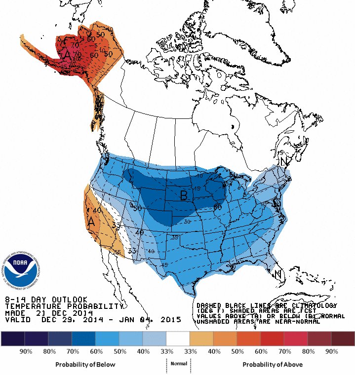
And we get this from CPC/HPC/WPC/MPC/ABC etc.............
_________________
Mugs
AKA:King: Snow Weenie
Self Proclaimed
WINTER 2014-15 : 55.12" +.02 for 6 coatings (avg. 35")
WINTER 2015-16 Total - 29.8" (Avg 35")
WINTER 2016-17 : 39.5" so far
amugs- Advanced Forecaster - Mod
- Posts : 15093
Reputation : 213
Join date : 2013-01-07
Age : 54
Location : Hillsdale,NJ
Re: Official Long Range Thread 5.0
![]() by Frank_Wx Mon Dec 22, 2014 11:50 am
by Frank_Wx Mon Dec 22, 2014 11:50 am

_________________
_______________________________________________________________________________________________________
CLICK HERE to view NJ Strong Snowstorm Classifications
Frank_Wx- Godzilla Seeker
- Posts : 21305
Reputation : 328
Join date : 2013-01-05
Age : 31
Location : Jersey City, NJ -
Re: Official Long Range Thread 5.0
![]() by Frank_Wx Mon Dec 22, 2014 11:56 am
by Frank_Wx Mon Dec 22, 2014 11:56 am
_________________
_______________________________________________________________________________________________________
CLICK HERE to view NJ Strong Snowstorm Classifications
Frank_Wx- Godzilla Seeker
- Posts : 21305
Reputation : 328
Join date : 2013-01-05
Age : 31
Location : Jersey City, NJ -
Re: Official Long Range Thread 5.0
![]() by crippo84 Mon Dec 22, 2014 12:02 pm
by crippo84 Mon Dec 22, 2014 12:02 pm
Frank_Wx wrote:GFS still showing snow around the 30th. Would like to see other models jump on board.
You may have mentioned this before, but what amendments were made to the GFS model to give us the GFS-Parallel? What are the overall differences in the two models, and which (so far) do you prefer to use? The models (GFS and GFS Para) are taking two different positions on the possible storm around the 30th. Another model to add to the mayhem.

crippo84- Posts : 383
Reputation : 20
Join date : 2013-11-07
Age : 40
Location : East Village, NYC
Re: Official Long Range Thread 5.0
![]() by Frank_Wx Mon Dec 22, 2014 12:33 pm
by Frank_Wx Mon Dec 22, 2014 12:33 pm
crippo84 wrote:Frank_Wx wrote:GFS still showing snow around the 30th. Would like to see other models jump on board.
You may have mentioned this before, but what amendments were made to the GFS model to give us the GFS-Parallel? What are the overall differences in the two models, and which (so far) do you prefer to use? The models (GFS and GFS Para) are taking two different positions on the possible storm around the 30th. Another model to add to the mayhem.
I no longer use the old GFS. Its a lower resolution models that had too many well known bias'. The Para is higher resolution and contains a little better programming. They're getting rid of the old GFS in Jan. Or Feb
_________________
_______________________________________________________________________________________________________
CLICK HERE to view NJ Strong Snowstorm Classifications
Frank_Wx- Godzilla Seeker
- Posts : 21305
Reputation : 328
Join date : 2013-01-05
Age : 31
Location : Jersey City, NJ -
Re: Official Long Range Thread 5.0
![]() by algae888 Mon Dec 22, 2014 1:28 pm
by algae888 Mon Dec 22, 2014 1:28 pm

algae888- Advanced Forecaster

- Posts : 5311
Reputation : 46
Join date : 2013-02-05
Age : 61
Location : mt. vernon, new york
Re: Official Long Range Thread 5.0
![]() by jmanley32 Mon Dec 22, 2014 1:30 pm
by jmanley32 Mon Dec 22, 2014 1:30 pm

jmanley32- Senior Enthusiast
- Posts : 20516
Reputation : 108
Join date : 2013-12-12
Age : 42
Location : Yonkers, NY
Re: Official Long Range Thread 5.0
![]() by Frank_Wx Mon Dec 22, 2014 1:36 pm
by Frank_Wx Mon Dec 22, 2014 1:36 pm
All 3 models show a storm. Track is going to waffle a billion times. We'll analyze more after Xmas

_________________
_______________________________________________________________________________________________________
CLICK HERE to view NJ Strong Snowstorm Classifications
Frank_Wx- Godzilla Seeker
- Posts : 21305
Reputation : 328
Join date : 2013-01-05
Age : 31
Location : Jersey City, NJ -
Re: Official Long Range Thread 5.0
![]() by jmanley32 Mon Dec 22, 2014 1:49 pm
by jmanley32 Mon Dec 22, 2014 1:49 pm
jmanley32- Senior Enthusiast
- Posts : 20516
Reputation : 108
Join date : 2013-12-12
Age : 42
Location : Yonkers, NY
Re: Official Long Range Thread 5.0
![]() by jmanley32 Mon Dec 22, 2014 1:52 pm
by jmanley32 Mon Dec 22, 2014 1:52 pm
jmanley32- Senior Enthusiast
- Posts : 20516
Reputation : 108
Join date : 2013-12-12
Age : 42
Location : Yonkers, NY
Re: Official Long Range Thread 5.0
![]() by CPcantmeasuresnow Mon Dec 22, 2014 1:57 pm
by CPcantmeasuresnow Mon Dec 22, 2014 1:57 pm
As Docstox and the guy from Shawshank redemption said " hope is a good thing".
CPcantmeasuresnow- Wx Statistician Guru
- Posts : 7274
Reputation : 230
Join date : 2013-01-07
Age : 103
Location : Eastern Orange County, NY
Re: Official Long Range Thread 5.0
![]() by Frank_Wx Mon Dec 22, 2014 1:59 pm
by Frank_Wx Mon Dec 22, 2014 1:59 pm
The theme with all the storm threats per Euro is that there is energy digging into the SW Conus as the storms on the east get there act together. With the PNA being disrupted, this allows the SE ridge to flex and pave a storm track right toward our area. We're basically along the baroclinic zone.
If true, these types of storms could produce but always thread the needle.
_________________
_______________________________________________________________________________________________________
CLICK HERE to view NJ Strong Snowstorm Classifications
Frank_Wx- Godzilla Seeker
- Posts : 21305
Reputation : 328
Join date : 2013-01-05
Age : 31
Location : Jersey City, NJ -
Re: Official Long Range Thread 5.0
![]() by Frank_Wx Mon Dec 22, 2014 2:11 pm
by Frank_Wx Mon Dec 22, 2014 2:11 pm
_________________
_______________________________________________________________________________________________________
CLICK HERE to view NJ Strong Snowstorm Classifications
Frank_Wx- Godzilla Seeker
- Posts : 21305
Reputation : 328
Join date : 2013-01-05
Age : 31
Location : Jersey City, NJ -
Re: Official Long Range Thread 5.0
![]() by amugs Mon Dec 22, 2014 2:21 pm
by amugs Mon Dec 22, 2014 2:21 pm
Frank_Wx wrote:I just feel we have to stay a little realistic at this point. There's a lot of moving parts and we are yet to see consistency. Personally, I don't like the fact the Pac. Jet continues to look strong and s/w's are digging along the east quadrant of the east Pacific ridge. There's some blocking in central and eastern Canada that helps to keep all the energy from cutting, but the southeast ridge is still there which could either hurt or benefit us
That PAC flow needs to be +PNA's or it remains progressive and we get screwed IMO - what can help overcome that - A decent -AO or a true - NAO : 50/50 block.
Euro over amplifying everything that gets shredded and turn to poop inside 96-72 hours - need a good cold air source to tap into for these storms and need that cross polar flow to take shape.
Ahhhh poop I am coming back after xmass eve/xmass. I need a frickin Jack n sometin' at this point looking at H5 maps and models verbatim.

Until then a VERY Merry Xmass to you all on this wonderful board. Enjoy the time with family and friends.
_________________
Mugs
AKA:King: Snow Weenie
Self Proclaimed
WINTER 2014-15 : 55.12" +.02 for 6 coatings (avg. 35")
WINTER 2015-16 Total - 29.8" (Avg 35")
WINTER 2016-17 : 39.5" so far
amugs- Advanced Forecaster - Mod
- Posts : 15093
Reputation : 213
Join date : 2013-01-07
Age : 54
Location : Hillsdale,NJ
Re: Official Long Range Thread 5.0
![]() by Frank_Wx Mon Dec 22, 2014 2:28 pm
by Frank_Wx Mon Dec 22, 2014 2:28 pm
_________________
_______________________________________________________________________________________________________
CLICK HERE to view NJ Strong Snowstorm Classifications
Frank_Wx- Godzilla Seeker
- Posts : 21305
Reputation : 328
Join date : 2013-01-05
Age : 31
Location : Jersey City, NJ -
Re: Official Long Range Thread 5.0
![]() by Guest Mon Dec 22, 2014 4:01 pm
by Guest Mon Dec 22, 2014 4:01 pm
Guest- Guest
Re: Official Long Range Thread 5.0
![]() by Frank_Wx Mon Dec 22, 2014 4:06 pm
by Frank_Wx Mon Dec 22, 2014 4:06 pm
syosnow94 wrote:MERRY CHRISTMAS EVERYONE!! Let me translate. SHOCKING DEVELOPMENTS!! We will not be as cold and snowy as previously forecast! There may be some storms but more than likely mixing issues LOL. Be patient things might change. I just summarized 3 pages of scientific model analysis in 2 sentences.
Well you summarized them incorrectly. The previous forecast is still the current forecast, and that is a pattern change around the 28th. No one has forecasted any snow or mixed precip for any time frame, besides the rain for Xmas Eve which has its own thread.
_________________
_______________________________________________________________________________________________________
CLICK HERE to view NJ Strong Snowstorm Classifications
Frank_Wx- Godzilla Seeker
- Posts : 21305
Reputation : 328
Join date : 2013-01-05
Age : 31
Location : Jersey City, NJ -
Re: Official Long Range Thread 5.0
![]() by docstox12 Mon Dec 22, 2014 4:25 pm
by docstox12 Mon Dec 22, 2014 4:25 pm
amugs wrote:Frank_Wx wrote:I just feel we have to stay a little realistic at this point. There's a lot of moving parts and we are yet to see consistency. Personally, I don't like the fact the Pac. Jet continues to look strong and s/w's are digging along the east quadrant of the east Pacific ridge. There's some blocking in central and eastern Canada that helps to keep all the energy from cutting, but the southeast ridge is still there which could either hurt or benefit us
That PAC flow needs to be +PNA's or it remains progressive and we get screwed IMO - what can help overcome that - A decent -AO or a true - NAO : 50/50 block.
Euro over amplifying everything that gets shredded and turn to poop inside 96-72 hours - need a good cold air source to tap into for these storms and need that cross polar flow to take shape.
Ahhhh poop I am coming back after xmass eve/xmass. I need a frickin Jack n sometin' at this point looking at H5 maps and models verbatim.
Until then a VERY Merry Xmass to you all on this wonderful board. Enjoy the time with family and friends.
Make that Jack a double, Mugsy and God Bless you and your's on this Christmas Day to come.

docstox12- Wx Statistician Guru
- Posts : 8504
Reputation : 222
Join date : 2013-01-07
Age : 73
Location : Monroe NY
Page 14 of 40 • 1 ... 8 ... 13, 14, 15 ... 27 ... 40 ![]()
|
|
|