
 Search
Official Long Range Thread 5.0
Page 13 of 40 •  1 ... 8 ... 12, 13, 14 ... 26 ... 40
 ![]()
Re: Official Long Range Thread 5.0
![]() by jmanley32 Sun Dec 21, 2014 5:36 pm
by jmanley32 Sun Dec 21, 2014 5:36 pm
jmanley32- Senior Enthusiast

- Posts : 20513
Join date : 2013-12-12
Re: Official Long Range Thread 5.0
![]() by jmanley32 Sun Dec 21, 2014 5:40 pm
by jmanley32 Sun Dec 21, 2014 5:40 pm
jmanley32- Senior Enthusiast
- Posts : 20513
Join date : 2013-12-12
Re: Official Long Range Thread 5.0
![]() by Guest Sun Dec 21, 2014 5:43 pm
by Guest Sun Dec 21, 2014 5:43 pm
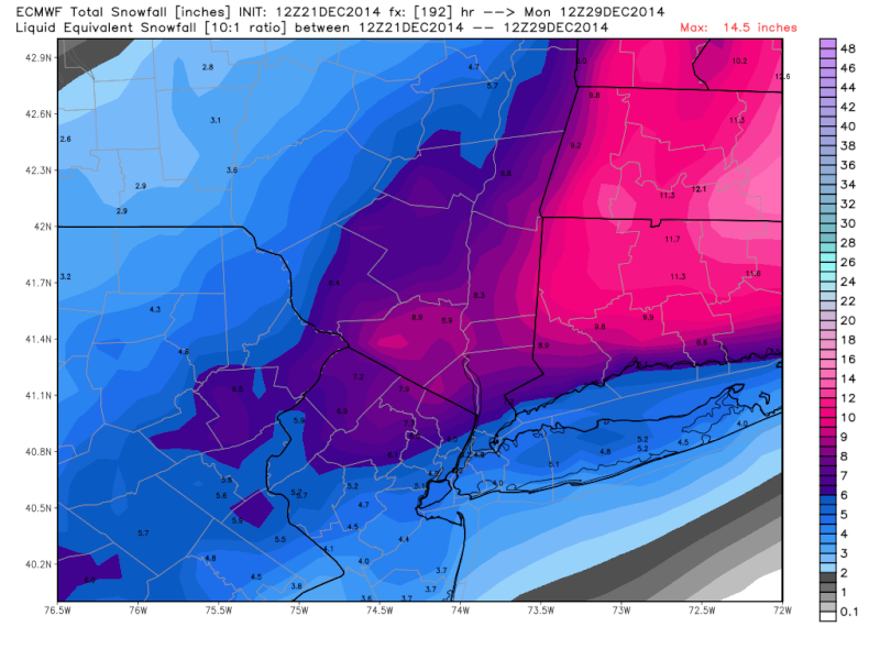
Could somebody please explain how NWS has temps in 40s and put out a forecast for liguid precip. and an inland track but other models show significant snow. I DON'T UNDERSTAND!!! And unfortunately NWS has been right EVERY forecast so far it seems while we sit here and dream and wish for snow/cold that hasn't and doesn't come.jmanley32 wrote:Per the request of some users I am posting the useless snow map, just to add insult to injury for something that probably will not happen, its not a huge snowfall but its something and east gets hammered, plenty of time to watch this, Al if NWS says all liquid I dunno what to think, Frank its a very good sign that the ensembles like the 28th. But I am losing faith in any of the long range, which is why the map is FOR FUN ONLY! Some of you will not be happy but I see it as a potential for the area, havent looked at ensembles but I am sure some are easst some are west. No one better say anything I was ASKED to post this : )
Guest- Guest
Re: Official Long Range Thread 5.0
![]() by Frank_Wx Sun Dec 21, 2014 5:51 pm
by Frank_Wx Sun Dec 21, 2014 5:51 pm
_________________
_______________________________________________________________________________________________________
CLICK HERE to view NJ Strong Snowstorm Classifications

Frank_Wx- Godzilla Seeker

- Posts : 21305
Reputation : 328
Join date : 2013-01-05
Age : 31
Location : Jersey City, NJ -

Re: Official Long Range Thread 5.0
![]() by Math23x7 Sun Dec 21, 2014 6:36 pm
by Math23x7 Sun Dec 21, 2014 6:36 pm
Math23x7- Wx Statistician Guru

- Posts : 2379
Reputation : 68
Join date : 2013-01-08
Re: Official Long Range Thread 5.0
![]() by skinsfan1177 Sun Dec 21, 2014 6:50 pm
by skinsfan1177 Sun Dec 21, 2014 6:50 pm
Last edited by skinsfan1177 on Sun Dec 21, 2014 7:41 pm; edited 1 time in total

skinsfan1177- Senior Enthusiast
- Posts : 4485
Reputation : 35
Join date : 2013-01-07
Age : 46
Location : Point Pleasant Boro
Re: Official Long Range Thread 5.0
![]() by CPcantmeasuresnow Sun Dec 21, 2014 7:25 pm
by CPcantmeasuresnow Sun Dec 21, 2014 7:25 pm
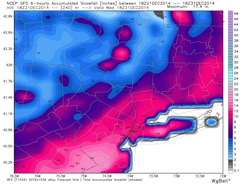
Math23x7 wrote:The 12/21 18Z Parallel GFS for December 30th.....I can dream can't I...
Pictures please. We'd all like to dream, not that I ever believe anything that far out but it's all we have right now.

CPcantmeasuresnow- Wx Statistician Guru
- Posts : 7274
Reputation : 230
Join date : 2013-01-07
Age : 103
Location : Eastern Orange County, NY
Re: Official Long Range Thread 5.0
![]() by Math23x7 Sun Dec 21, 2014 8:11 pm
by Math23x7 Sun Dec 21, 2014 8:11 pm
CPcantmeasuresnow wrote:Math23x7 wrote:The 12/21 18Z Parallel GFS for December 30th.....I can dream can't I...
Pictures please. We'd all like to dream, not that I ever believe anything that far out but it's all we have right now.
I wish I could, but it's weatherbell and I dont want to face legal action if I post it. I'm not sure if stormvista has restrictions because I am not a subscriber to it. If not, maybe Frank or one of the others could post hr 210 of the 12/21 18Z Parallel GFS because it shows good snow over the tri-state area. Widespread 6-12 inches of snow with this one.
Math23x7- Wx Statistician Guru
- Posts : 2379
Reputation : 68
Join date : 2013-01-08
Re: Official Long Range Thread 5.0
![]() by sroc4 Sun Dec 21, 2014 8:16 pm
by sroc4 Sun Dec 21, 2014 8:16 pm
Math23x7 wrote:CPcantmeasuresnow wrote:Math23x7 wrote:The 12/21 18Z Parallel GFS for December 30th.....I can dream can't I...
Pictures please. We'd all like to dream, not that I ever believe anything that far out but it's all we have right now.
I wish I could, but it's weatherbell and I dont want to face legal action if I post it. I'm not sure if stormvista has restrictions because I am not a subscriber to it. If not, maybe Frank or one of the others could post hr 210 of the 12/21 18Z Parallel GFS because it shows good snow over the tri-state area. Widespread 6-12 inches of snow with this one.
I aint scared Mike, but I am drunk and full.

[img]
 [/img]
_________________
"In weather and in life, there's no winning and losing; there's only winning and learning."
WINTER 2012/2013 TOTALS 43.65"WINTER 2017/2018 TOTALS 62.85" WINTER 2022/2023 TOTALS 4.9"
WINTER 2013/2014 TOTALS 64.85"WINTER 2018/2019 TOTALS 14.25" WINTER 2023/2024 TOTALS 13.1"
WINTER 2014/2015 TOTALS 71.20"WINTER 2019/2020 TOTALS 6.35"
WINTER 2015/2016 TOTALS 35.00"WINTER 2020/2021 TOTALS 37.75"
WINTER 2016/2017 TOTALS 42.25"WINTER 2021/2022 TOTALS 31.65"

sroc4- Admin
- Posts : 8331
Reputation : 301
Join date : 2013-01-07
Location : Wading River, LI
Re: Official Long Range Thread 5.0
![]() by sroc4 Sun Dec 21, 2014 8:17 pm
by sroc4 Sun Dec 21, 2014 8:17 pm
 [/img]
_________________
"In weather and in life, there's no winning and losing; there's only winning and learning."
WINTER 2012/2013 TOTALS 43.65"WINTER 2017/2018 TOTALS 62.85" WINTER 2022/2023 TOTALS 4.9"
WINTER 2013/2014 TOTALS 64.85"WINTER 2018/2019 TOTALS 14.25" WINTER 2023/2024 TOTALS 13.1"
WINTER 2014/2015 TOTALS 71.20"WINTER 2019/2020 TOTALS 6.35"
WINTER 2015/2016 TOTALS 35.00"WINTER 2020/2021 TOTALS 37.75"
WINTER 2016/2017 TOTALS 42.25"WINTER 2021/2022 TOTALS 31.65"
sroc4- Admin
- Posts : 8331
Reputation : 301
Join date : 2013-01-07
Location : Wading River, LI
Re: Official Long Range Thread 5.0
![]() by jmanley32 Sun Dec 21, 2014 8:38 pm
by jmanley32 Sun Dec 21, 2014 8:38 pm

jmanley32- Senior Enthusiast
- Posts : 20513
Reputation : 108
Join date : 2013-12-12
Age : 42
Location : Yonkers, NY
Re: Official Long Range Thread 5.0
![]() by jmanley32 Sun Dec 21, 2014 8:46 pm
by jmanley32 Sun Dec 21, 2014 8:46 pm
jmanley32- Senior Enthusiast
- Posts : 20513
Reputation : 108
Join date : 2013-12-12
Age : 42
Location : Yonkers, NY
Re: Official Long Range Thread 5.0
![]() by Frank_Wx Sun Dec 21, 2014 8:56 pm
by Frank_Wx Sun Dec 21, 2014 8:56 pm
jmanley32 wrote:Sweet, lets all dream : ) This would be seperate from the system at hr 180 on Euro or is it the same just a different timeframe? And Frank I did not know NWS based off GFS, interesting because they mention other models.
I meant their 7 day point and click forecasts are generated based off the GFS. Their discussions are real. Lol
_________________
_______________________________________________________________________________________________________
CLICK HERE to view NJ Strong Snowstorm Classifications
Frank_Wx- Godzilla Seeker
- Posts : 21305
Reputation : 328
Join date : 2013-01-05
Age : 31
Location : Jersey City, NJ -
Re: Official Long Range Thread 5.0
![]() by Frank_Wx Sun Dec 21, 2014 9:28 pm
by Frank_Wx Sun Dec 21, 2014 9:28 pm
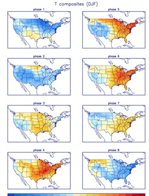
LR forecasting is so volatile. There's so many different moving parts and surprise wild cards that it is nearly impossible to try and achieve 100% accuracy. For example, the MJO is currently forecasted to go through phases 4-5-6 after Xmas. These phases correlate to warmer than normal temps on the east coast.
1977-1978, a common analog thrown around for this season, also experienced an MJO in January in those same exact phases but temps on thr east coast were well below normal with a couple of snowstorms. When other factors align favorably, they can override the negatives and the results would surprise some of us compared to what we expected to happen.
Behind this story is a simple message: we know much less than what we think.
Attached Images


_________________
_______________________________________________________________________________________________________
CLICK HERE to view NJ Strong Snowstorm Classifications
Frank_Wx- Godzilla Seeker
- Posts : 21305
Reputation : 328
Join date : 2013-01-05
Age : 31
Location : Jersey City, NJ -
Re: Official Long Range Thread 5.0
![]() by docstox12 Sun Dec 21, 2014 9:55 pm
by docstox12 Sun Dec 21, 2014 9:55 pm
Frank_Wx wrote:CP you may appreciate this post since we briefly discussed 77-78 together
LR forecasting is so volatile. There's so many different moving parts and surprise wild cards that it is nearly impossible to try and achieve 100% accuracy. For example, the MJO is currently forecasted to go through phases 4-5-6 after Xmas. These phases correlate to warmer than normal temps on the east coast.
1977-1978, a common analog thrown around for this season, also experienced an MJO in January in those same exact phases but temps on thr east coast were well below normal with a couple of snowstorms. When other factors align favorably, they can override the negatives and the results would surprise some of us compared to what we expected to happen.
Behind this story is a simple message: we know much less than what we think.Attached Images
Obviously in '77-'78 the MJO signal was over ridden by other factors as you say.Specifically what factors were they in order to obtain a bit more data on how the MJO indicator failed that January?You and I share a common theme here, I use long range indicators in my stock investment operations and find that some indicators outweigh the others.After 14 years of doing this, you start to get a feel for certain indicators, or in weather parlance. EURO more reliable than GFS.I think from observing the long range discussions for as long as I have been here on the board, getting even 40 to 50% accuracy in long range is asking a lot.My stock indicators give me 60 to 70% success which is why I can make a living at it.It's the skill in interpreting the indicators or models that tell the tale.

docstox12- Wx Statistician Guru
- Posts : 8502
Reputation : 222
Join date : 2013-01-07
Age : 73
Location : Monroe NY
Re: Official Long Range Thread 5.0
![]() by Guest Sun Dec 21, 2014 10:13 pm
by Guest Sun Dec 21, 2014 10:13 pm
Frank_Wx wrote:NWS forecasts are based off the GFS model.
thanks
Guest- Guest
Re: Official Long Range Thread 5.0
![]() by Frank_Wx Sun Dec 21, 2014 10:17 pm
by Frank_Wx Sun Dec 21, 2014 10:17 pm
docstox12 wrote:Frank_Wx wrote:CP you may appreciate this post since we briefly discussed 77-78 together
LR forecasting is so volatile. There's so many different moving parts and surprise wild cards that it is nearly impossible to try and achieve 100% accuracy. For example, the MJO is currently forecasted to go through phases 4-5-6 after Xmas. These phases correlate to warmer than normal temps on the east coast.
1977-1978, a common analog thrown around for this season, also experienced an MJO in January in those same exact phases but temps on thr east coast were well below normal with a couple of snowstorms. When other factors align favorably, they can override the negatives and the results would surprise some of us compared to what we expected to happen.
Behind this story is a simple message: we know much less than what we think.Attached Images
Obviously in '77-'78 the MJO signal was over ridden by other factors as you say.Specifically what factors were they in order to obtain a bit more data on how the MJO indicator failed that January?You and I share a common theme here, I use long range indicators in my stock investment operations and find that some indicators outweigh the others.After 14 years of doing this, you start to get a feel for certain indicators, or in weather parlance. EURO more reliable than GFS.I think from observing the long range discussions for as long as I have been here on the board, getting even 40 to 50% accuracy in long range is asking a lot.My stock indicators give me 60 to 70% success which is why I can make a living at it.It's the skill in interpreting the indicators or models that tell the tale.
Good question-
From my winter outlook, I noticed that year had a +PDO, +ENSO, and a +QBO. Everything matches so far except the QBO, which for us now is currently -25 where in Jan 1978 it was +3.21. That's a pretty big difference and explains why the stratosphere is giving us some issues so far this season. The NAO was mainly neutral in Jan of 1978 but went extremely negative by February. This is interesting too because our NAO looks to be around neutral to open Jan.
QBO aside, this season the way it's going so far is matching up very closely to 77-78. Let's see how the patteen looks after Xmas.
_________________
_______________________________________________________________________________________________________
CLICK HERE to view NJ Strong Snowstorm Classifications
Frank_Wx- Godzilla Seeker
- Posts : 21305
Reputation : 328
Join date : 2013-01-05
Age : 31
Location : Jersey City, NJ -
Re: Official Long Range Thread 5.0
![]() by docstox12 Sun Dec 21, 2014 10:37 pm
by docstox12 Sun Dec 21, 2014 10:37 pm
It will be interesting to see how Jan-Feb this year turn out if that QBO resides in that -25 territory with the MJO giving a warm signal.
Love these comparisons to other years to get a fix on the indicator interactions and to put together more reliable data for better long range predictions.
In summary, you have enough here for a lifetime study especially with the better information to come as years go by.
As Spock would say......"Fascinating!"
docstox12- Wx Statistician Guru
- Posts : 8502
Reputation : 222
Join date : 2013-01-07
Age : 73
Location : Monroe NY
Re: Official Long Range Thread 5.0
![]() by Frank_Wx Sun Dec 21, 2014 10:41 pm
by Frank_Wx Sun Dec 21, 2014 10:41 pm
docstox12 wrote:OK, so from what I understand , that MJO in 78 indicating a warmer East Coast may have been cancelled out by that +3.21 QBO which was the only indicator that is materially different back then from now.Therefor, in that particular year, the QBO had more weight than the MJO.
It will be interesting to see how Jan-Feb this year turn out if that QBO resides in that -25 territory with the MJO giving a warm signal.
Love these comparisons to other years to get a fix on the indicator interactions and to put together more reliable data for better long range predictions.
In summary, you have enough here for a lifetime study especially with the better information to come as years go by.
As Spock would say......"Fascinating!"
Actually Doc, since current guidance is shwing below normal temps. from Dec. 27th and on...the MJO forecast may be wrong again. The question becomes does a switch to warmer weather happen around mid Jan. or can we hang on?
_________________
_______________________________________________________________________________________________________
CLICK HERE to view NJ Strong Snowstorm Classifications
Frank_Wx- Godzilla Seeker
- Posts : 21305
Reputation : 328
Join date : 2013-01-05
Age : 31
Location : Jersey City, NJ -
Re: Official Long Range Thread 5.0
![]() by Frank_Wx Sun Dec 21, 2014 11:29 pm
by Frank_Wx Sun Dec 21, 2014 11:29 pm
_________________
_______________________________________________________________________________________________________
CLICK HERE to view NJ Strong Snowstorm Classifications
Frank_Wx- Godzilla Seeker
- Posts : 21305
Reputation : 328
Join date : 2013-01-05
Age : 31
Location : Jersey City, NJ -
Re: Official Long Range Thread 5.0
![]() by Frank_Wx Sun Dec 21, 2014 11:35 pm
by Frank_Wx Sun Dec 21, 2014 11:35 pm
The new GFS also shows a coastal storm at the same time with a much more likely evolution. Nice look!

_________________
_______________________________________________________________________________________________________
CLICK HERE to view NJ Strong Snowstorm Classifications
Frank_Wx- Godzilla Seeker
- Posts : 21305
Reputation : 328
Join date : 2013-01-05
Age : 31
Location : Jersey City, NJ -
Re: Official Long Range Thread 5.0
![]() by jmanley32 Mon Dec 22, 2014 6:26 am
by jmanley32 Mon Dec 22, 2014 6:26 am
jmanley32- Senior Enthusiast
- Posts : 20513
Reputation : 108
Join date : 2013-12-12
Age : 42
Location : Yonkers, NY
Re: Official Long Range Thread 5.0
![]() by nutleyblizzard Mon Dec 22, 2014 6:46 am
by nutleyblizzard Mon Dec 22, 2014 6:46 am
Strange depiction, but the 6z para GFS shows an even stronger storm (978mb),but its way out to sea.jmanley32 wrote:Hopefully it comes west this thing on 00z is a absolute all out blizzard off the ne coast. If it can bomb earlier and more west we golden. Is this possible frank and how do uppers look?

nutleyblizzard- Senior Enthusiast
- Posts : 1952
Reputation : 41
Join date : 2014-01-30
Age : 58
Location : Nutley, new jersey
Re: Official Long Range Thread 5.0
![]() by nutleyblizzard Mon Dec 22, 2014 7:05 am
by nutleyblizzard Mon Dec 22, 2014 7:05 am
nutleyblizzard- Senior Enthusiast
- Posts : 1952
Reputation : 41
Join date : 2014-01-30
Age : 58
Location : Nutley, new jersey
Re: Official Long Range Thread 5.0
![]() by sroc4 Mon Dec 22, 2014 7:06 am
by sroc4 Mon Dec 22, 2014 7:06 am
Frank_Wx wrote:docstox12 wrote:OK, so from what I understand , that MJO in 78 indicating a warmer East Coast may have been cancelled out by that +3.21 QBO which was the only indicator that is materially different back then from now.Therefor, in that particular year, the QBO had more weight than the MJO.
It will be interesting to see how Jan-Feb this year turn out if that QBO resides in that -25 territory with the MJO giving a warm signal.
Love these comparisons to other years to get a fix on the indicator interactions and to put together more reliable data for better long range predictions.
In summary, you have enough here for a lifetime study especially with the better information to come as years go by.
As Spock would say......"Fascinating!"
Actually Doc, since current guidance is shwing below normal temps. from Dec. 27th and on...the MJO forecast may be wrong again. The question becomes does a switch to warmer weather happen around mid Jan. or can we hang on?
Or do we switch sooner than mid Jan. The latest Euro ens mean 500mb shows a textbook pattern in NA when compared with the MJO forecast into Octanes 3, 4, 5 by both the Euro and GEFS. Keep in mind the GEFS 500mb mean and the CMC ensemble mean do not quite look like what you see below. The SE ridge in the East and a trough in the west leading to above normal temp anomalies in the east and below in the west. Vomited in my mouth a little. Its a good thing the LR has rarely verified this season even on the Euro. Some of you may stop reading after viewing the images below because its going to upset you too much but I encourage you to continue reading below the images.
Euro:

GEFS:

 " />
" /> " />
" /> " />
" />The reason I am showing you all this right now is because this is about the worst case scenario for snow and cold weenies like you and me. Sometimes you need to hit rock bottom before you can begin to build yourself back up. The first part of the serenity prayer reads, God grant me the serenity to accept the things I cannot change. Folks we cannot change the weather. Mother Nature and Old Man winter will do what they want to do and there is nothing you nor I can do about it. We all need to try our best to avoid the 16yr old high school girl mood swings when the weather doesn't pan out the way we want in our back yards. Here is a brilliant post from facebook written by meteorologist Joe Cioffi:
"Since you young-ins haven't been around long enough like this old man here..let me point out to you that from 1970 to 2000 25 of those 30 years in NYC produced below average (28.4) snowfall. Only 5 winters were either normal or above. Clearly that was a 30 year down cycle. Chicago went from 1979 to 1997 without seeing a single 10 inch or more snowstorm! 18 years. I spent most of those 30 years watching horrible patterns come and go, good patterns producing nothing. And every once in awhile you got something worth getting excited over.
From 2000-2014 it has been a snow bonaza in NYC. 9 of the 14 winters have been above normal. For Long Island it has been extra special. The average over that period has been over 40 inches! We've had winters where you could have just sat back and gone 6 to 12 and put the forecast to bed early because you were in a bowling alley hitting the head pin almost every time.
Looking long range is fun..and it is important in figuring out where we are going..but for God sakes can we please stop running for prozac every time a model does something we like or don't like. Anything outside 96 hours is fair game for huge change..anything inside 96 hours and its time to get excited. Otherwise any snow map, any proposed model solution can rank anywhere from reasonable to "clown" map. Open minds people for all solutions in all directions. And i am amazed at how personal some people take all this. If this winds up being a sub par winter..so be it. We are shooting for 5 winters in 6 of above normal snowfall and that rarely happens (nyc last time was in the 1880s). So let it just play out. We have 11 weeks ahead of us."
This is where I state the remaining part of the serenity prayer. .......the courage to change the things I can, and the wisdom to know the difference. Folks go enjoy the holidays with your families and stay away from the computer for awhile. Its going to be windy and rainy around Christmas and above normal temps. There is a chance towards the end of the month for a system to affect the area. Might have rain might have snow, might have rain and snow, and might miss completely. Check back after Christmas for more details, because until the models see what the Christmas eve system does to the upper levels as it moves up and into Canada we will not see consistency for anything after. I am going to coin this phrase..."Go hug a human this holiday season, not a weather model" sroc4
Happy Holidays Everyone!!
Last edited by sroc4 on Mon Dec 22, 2014 7:58 am; edited 1 time in total
_________________
"In weather and in life, there's no winning and losing; there's only winning and learning."
WINTER 2012/2013 TOTALS 43.65"WINTER 2017/2018 TOTALS 62.85" WINTER 2022/2023 TOTALS 4.9"
WINTER 2013/2014 TOTALS 64.85"WINTER 2018/2019 TOTALS 14.25" WINTER 2023/2024 TOTALS 13.1"
WINTER 2014/2015 TOTALS 71.20"WINTER 2019/2020 TOTALS 6.35"
WINTER 2015/2016 TOTALS 35.00"WINTER 2020/2021 TOTALS 37.75"
WINTER 2016/2017 TOTALS 42.25"WINTER 2021/2022 TOTALS 31.65"
sroc4- Admin
- Posts : 8331
Reputation : 301
Join date : 2013-01-07
Location : Wading River, LI
Re: Official Long Range Thread 5.0
![]() by docstox12 Mon Dec 22, 2014 7:20 am
by docstox12 Mon Dec 22, 2014 7:20 am
Cioffi hit the nail on the head.
Good idea, Doc, to take a break, enjoy family and see what happens in a week.
docstox12- Wx Statistician Guru
- Posts : 8502
Reputation : 222
Join date : 2013-01-07
Age : 73
Location : Monroe NY
Re: Official Long Range Thread 5.0
![]() by jmanley32 Mon Dec 22, 2014 8:59 am
by jmanley32 Mon Dec 22, 2014 8:59 am
jmanley32- Senior Enthusiast
- Posts : 20513
Reputation : 108
Join date : 2013-12-12
Age : 42
Location : Yonkers, NY
Page 13 of 40 • 1 ... 8 ... 12, 13, 14 ... 26 ... 40 ![]()
|
|
|